Is the conclusion obvious? SST's are a fairly small part of predicting seasonal activity? As long as SST's are warm enough to support tropical cyclones then upper air patterns are probably the most critical ingredient. This holds unless SST's are well below normal, in my opinion. Well above normal SST's might aid in quick spinups of storms, but other factors will be more important to determine the strength and lifespan. Combine above normal SST's and very favorable upper air patterns and maybe you get an above normal season, but I don't think anyone here, nor any expert, can claim to understand what it takes to cross the man made threshold of hyperactive.
For all of this, we're setting the odds. Higher SST's increase the odds by some unknown percentage. More waves increase the odds. Certain patterns may or may not increase the odds, etc. Unfortunately, even though it seems like we have a lot of data, we really don't. If we did the forecasts that use hindcasting to try and predict future results would be very accurate. They aren't. We still have seasons that surprise us and add to the data.
So where this ends up, unfortunately, is a lot of amateurs make predictions. Some of those will come true, but not because their predictions were correct. That's the key point to understand in all of this, and why repeated verification is SO important. My opinion, of course.
2021 Indicators: SST's / SAL / MSLP / Shear / Steering / Instability / Sat Images
Moderator: S2k Moderators
Forum rules

The posts in this forum are NOT official forecasts and should not be used as such. They are just the opinion of the poster and may or may not be backed by sound meteorological data. They are NOT endorsed by any professional institution or STORM2K. For official information, please refer to products from the National Hurricane Center and National Weather Service.
-
tolakram
- Admin

- Posts: 20186
- Age: 62
- Joined: Sun Aug 27, 2006 8:23 pm
- Location: Florence, KY (name is Mark)
Re: 2021 Indicators: SST's / SAL / MSLP / Shear / Steering / Instability / Sat Images
12 likes
M a r k
- - - - -
Join us in chat: Storm2K Chatroom Invite. Android and IOS apps also available.
The posts in this forum are NOT official forecasts and should not be used as such. Posts are NOT endorsed by any professional institution or STORM2K.org. For official information and forecasts, please refer to NHC and NWS products.
-
Category5Kaiju

- Category 5

- Posts: 4334
- Joined: Thu Dec 24, 2020 12:45 pm
- Location: Seattle and Phoenix
Re: 2021 Indicators: SST's / SAL / MSLP / Shear / Steering / Instability / Sat Images
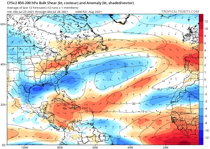
CyclonicFury wrote:For some reason, despite a La Niña and warmer than normal MDR SSTs, the CFSv2 is predicting above-normal wind shear over the MDR and Caribbean for ASO.
https://i.imgur.com/OlitqQP_d.webp?maxwidth=640&shape=thumb&fidelity=medium
Is that configuration even possible? That literally defies the reason why a La Nina is naturally a plus for above average Atlantic activity.
0 likes
Unless explicitly stated, all info in my posts is based on my own opinions and observations. Tropical storms and hurricanes can be extremely dangerous. Refer to an accredited weather research agency or meteorologist if you need to make serious decisions regarding an approaching storm.
-
CyclonicFury

- Category 5
- Posts: 2035
- Age: 27
- Joined: Sun Jul 02, 2017 12:32 pm
- Location: NC
- Contact:
Re: 2021 Indicators: SST's / SAL / MSLP / Shear / Steering / Instability / Sat Images
Category5Kaiju wrote:CyclonicFury wrote:For some reason, despite a La Niña and warmer than normal MDR SSTs, the CFSv2 is predicting above-normal wind shear over the MDR and Caribbean for ASO.
https://i.imgur.com/OlitqQP_d.webp?maxwidth=640&shape=thumb&fidelity=medium
Is that configuration even possible? That literally defies the reason why a La Nina is naturally a plus for above average Atlantic activity.
Apparently it showed something similar last year around this time, which verified poorly. It could be some sort of model bias related to MJO progression.


8 likes
NCSU B.S. in Meteorology Class of 2021. Tropical weather blogger at http://www.cyclonicfury.com. My forecasts and thoughts are NOT official, for official forecasts please consult the National Hurricane Center.
-
AlphaToOmega
- Category 5
- Posts: 1448
- Joined: Sat Jun 26, 2021 10:51 am
- Location: Somewhere in Massachusetts
Re: 2021 Indicators: SST's / SAL / MSLP / Shear / Steering / Instability / Sat Images
Category5Kaiju wrote:CyclonicFury wrote:For some reason, despite a La Niña and warmer than normal MDR SSTs, the CFSv2 is predicting above-normal wind shear over the MDR and Caribbean for ASO.
https://i.imgur.com/OlitqQP_d.webp?maxwidth=640&shape=thumb&fidelity=medium
Is that configuration even possible? That literally defies the reason why a La Nina is naturally a plus for above average Atlantic activity.
Below-average shear in the EPAC despite La Nina
This is why I do not use CFSv2 for long-term climate forecasts
0 likes
-
AutoPenalti
- Category 5
- Posts: 4091
- Age: 29
- Joined: Mon Aug 17, 2015 4:16 pm
- Location: Ft. Lauderdale, Florida
Re: 2021 Indicators: SST's / SAL / MSLP / Shear / Steering / Instability / Sat Images
Category5Kaiju wrote:CyclonicFury wrote:For some reason, despite a La Niña and warmer than normal MDR SSTs, the CFSv2 is predicting above-normal wind shear over the MDR and Caribbean for ASO.
https://i.imgur.com/OlitqQP_d.webp?maxwidth=640&shape=thumb&fidelity=medium
Is that configuration even possible? That literally defies the reason why a La Nina is naturally a plus for above average Atlantic activity.
It was discussed some pages back that the TUTT associated with a stronger EASJ and Rossby Wave may increase shear in the MDR.
1 likes
The posts in this forum are NOT official forecasts and should not be used as such. They are just the opinion of the poster and may or may not be backed by sound meteorological data. They are NOT endorsed by any professional institution or STORM2K. For official information, please refer to products from the NHC and NWS.
Model Runs Cheat Sheet:
GFS (5:30 AM/PM, 11:30 AM/PM)
HWRF, GFDL, UKMET, NAVGEM (6:30-8:00 AM/PM, 12:30-2:00 AM/PM)
ECMWF (1:45 AM/PM)
TCVN is a weighted averaged

Re: 2021 Indicators: SST's / SAL / MSLP / Shear / Steering / Instability / Sat Images
CyclonicFury wrote:Category5Kaiju wrote:CyclonicFury wrote:For some reason, despite a La Niña and warmer than normal MDR SSTs, the CFSv2 is predicting above-normal wind shear over the MDR and Caribbean for ASO.
https://i.imgur.com/OlitqQP_d.webp?maxwidth=640&shape=thumb&fidelity=medium
Is that configuration even possible? That literally defies the reason why a La Nina is naturally a plus for above average Atlantic activity.
Apparently it showed something similar last year around this time, which verified poorly. It could be some sort of model bias related to MJO progression.
https://i.imgur.com/LCsocok_d.webp?maxwidth=640&shape=thumb&fidelity=medium
https://i.imgur.com/5yh0Zbi_d.webp?maxwidth=640&shape=thumb&fidelity=medium
There was that time frame in the first half of September where shear was high due to that TUTT pumped by Maysak and Haishen in the WPac, so it only partially verified. However, shear wasn’t there when Teddy blew up into a Cat 4, and the later MDR storms struggled due to coming off of Africa too far north.
4 likes
Irene '11 Sandy '12 Hermine '16 5/15/2018 Derecho Fay '20 Isaias '20 Elsa '21 Henri '21 Ida '21
I am only a meteorology enthusiast who knows a decent amount about tropical cyclones. Look to the professional mets, the NHC, or your local weather office for the best information.
I am only a meteorology enthusiast who knows a decent amount about tropical cyclones. Look to the professional mets, the NHC, or your local weather office for the best information.
-
MarioProtVI
- Category 5
- Posts: 1034
- Age: 24
- Joined: Sun Sep 29, 2019 7:33 pm
- Location: New Jersey
Re: 2021 Indicators: SST's / SAL / MSLP / Shear / Steering / Instability / Sat Images
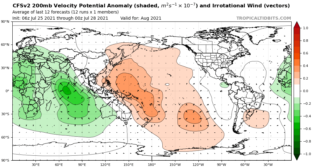
SFLcane wrote:AlphaToOmega wrote:CFSv2, just like the CanSIPS and JMA, finally suggests a favorable pattern for August:
https://i.postimg.cc/P5mPZCZ0/cfs-mon-01-chi200-global-1.png
But!?
https://i.postimg.cc/9MWx19Pq/FBF62068-5145-42-E3-9-FB5-4-CE66083234-B.jpg
CFS has a known bias to create pseudo El Niño conditions regardless of ENSO. Last year it predicted same thing and didn’t verify. So not buying CFS
8 likes
-
AlphaToOmega
- Category 5
- Posts: 1448
- Joined: Sat Jun 26, 2021 10:51 am
- Location: Somewhere in Massachusetts
Re: 2021 Indicators: SST's / SAL / MSLP / Shear / Steering / Instability / Sat Images
I made a spreadsheet of hurricane season activity and certain patterns (1980-2020):
https://docs.google.com/spreadsheets/d/1IiT2RLzZsymZ4Rc1WQEIvhul92egsnjFciaBGxkdSbU/edit?usp=sharing
https://docs.google.com/spreadsheets/d/1IiT2RLzZsymZ4Rc1WQEIvhul92egsnjFciaBGxkdSbU/edit?usp=sharing
4 likes
Re: 2021 Indicators: SST's / SAL / MSLP / Shear / Steering / Instability / Sat Images
Category5Kaiju wrote:AlphaToOmega wrote:CFSv2, just like the CanSIPS and JMA, finally suggests a favorable pattern for August:
https://i.postimg.cc/P5mPZCZ0/cfs-mon-01-chi200-global-1.png
Looks like the WPAC is going to have some trouble generating some powerful typhoons should that verify. Lots of sinking motion over the basin
That could prevent storms like Maysak and Haishen, which recurve at high latitudes and help create a strong TUTT that shreds MDR systems like last year. If it wasn’t for that, 2020 likely would have had a more impressive MDR than just Teddy and a few tropical storms that either fizzled out or peaked in the subtropics.
4 likes
Irene '11 Sandy '12 Hermine '16 5/15/2018 Derecho Fay '20 Isaias '20 Elsa '21 Henri '21 Ida '21
I am only a meteorology enthusiast who knows a decent amount about tropical cyclones. Look to the professional mets, the NHC, or your local weather office for the best information.
I am only a meteorology enthusiast who knows a decent amount about tropical cyclones. Look to the professional mets, the NHC, or your local weather office for the best information.
-
Category5Kaiju
- Category 5
- Posts: 4334
- Joined: Thu Dec 24, 2020 12:45 pm
- Location: Seattle and Phoenix
Re: 2021 Indicators: SST's / SAL / MSLP / Shear / Steering / Instability / Sat Images
aspen wrote:Category5Kaiju wrote:AlphaToOmega wrote:CFSv2, just like the CanSIPS and JMA, finally suggests a favorable pattern for August:
https://i.postimg.cc/P5mPZCZ0/cfs-mon-01-chi200-global-1.png
Looks like the WPAC is going to have some trouble generating some powerful typhoons should that verify. Lots of sinking motion over the basin
That could prevent storms like Maysak and Haishen, which recurve at high latitudes and help create a strong TUTT that shreds MDR systems like last year. If it wasn’t for that, 2020 likely would have had a more impressive MDR than just Teddy and a few tropical storms that either fizzled out or peaked in the subtropics.
While I only learned it last year, I never knew that even during a La Nina year the WPAC's storm tracks could actually impact the conditions in the Atlantic. Pretty cool imho to say the least.
3 likes
Unless explicitly stated, all info in my posts is based on my own opinions and observations. Tropical storms and hurricanes can be extremely dangerous. Refer to an accredited weather research agency or meteorologist if you need to make serious decisions regarding an approaching storm.
-
SFLcane

- S2K Supporter

- Posts: 10281
- Age: 48
- Joined: Sat Jun 05, 2010 1:44 pm
- Location: Lake Worth Florida
Re: 2021 Indicators: SST's / SAL / MSLP / Shear / Steering / Instability / Sat Images
AlphaToOmega wrote:I made a spreadsheet of hurricane season activity and certain patterns (1980-2020):
https://docs.google.com/spreadsheets/d/1IiT2RLzZsymZ4Rc1WQEIvhul92egsnjFciaBGxkdSbU/edit?usp=sharing
Where does this year fall?
0 likes
-
AlphaToOmega
- Category 5
- Posts: 1448
- Joined: Sat Jun 26, 2021 10:51 am
- Location: Somewhere in Massachusetts
Re: 2021 Indicators: SST's / SAL / MSLP / Shear / Steering / Instability / Sat Images
SFLcane wrote:AlphaToOmega wrote:I made a spreadsheet of hurricane season activity and certain patterns (1980-2020):
https://docs.google.com/spreadsheets/d/1IiT2RLzZsymZ4Rc1WQEIvhul92egsnjFciaBGxkdSbU/edit?usp=sharing
Where does this year fall?
Based on CanSIPS, 2021 is expected to have +AMO, +TNA, -ENSO, -PDO, -VP over Africa, and +VP over EPac, just like 2020 and 2010 (all of this is for ASO).
0 likes
-
SFLcane
- S2K Supporter
- Posts: 10281
- Age: 48
- Joined: Sat Jun 05, 2010 1:44 pm
- Location: Lake Worth Florida
Re: 2021 Indicators: SST's / SAL / MSLP / Shear / Steering / Instability / Sat Images
AlphaToOmega wrote:SFLcane wrote:AlphaToOmega wrote:I made a spreadsheet of hurricane season activity and certain patterns (1980-2020):
https://docs.google.com/spreadsheets/d/1IiT2RLzZsymZ4Rc1WQEIvhul92egsnjFciaBGxkdSbU/edit?usp=sharing
Where does this year fall?
Based on CanSIPS, 2021 is expected to have +AMO, +TNA, -ENSO, -PDO, -VP over Africa, and +VP over EPac, just like 2020 and 2010 (all of this is for ASO).
+AMO? The +VP over the East Pacific is a stretch.
1 likes
-
AlphaToOmega
- Category 5
- Posts: 1448
- Joined: Sat Jun 26, 2021 10:51 am
- Location: Somewhere in Massachusetts
Re: 2021 Indicators: SST's / SAL / MSLP / Shear / Steering / Instability / Sat Images
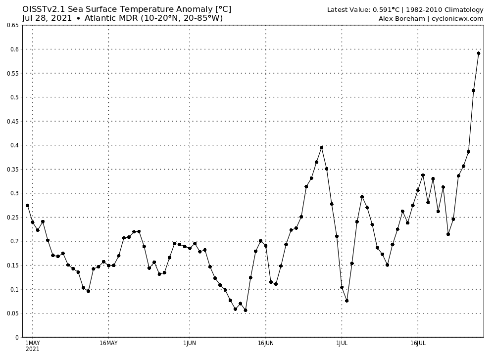
That is a hot MDR!
5 likes
-
Category5Kaiju
- Category 5
- Posts: 4334
- Joined: Thu Dec 24, 2020 12:45 pm
- Location: Seattle and Phoenix
Re: 2021 Indicators: SST's / SAL / MSLP / Shear / Steering / Instability / Sat Images
Also I would like to say this as I feel it is a very intriguing point, but when it comes down to having a "hyperactive season," having even at least only two or so storms but with each being an impressive long tracker can be enough to contribute roughly 100 or slightly more ACE to the hurricane season. For instance, I could have a season like 2020 (which produced 180 ACE) and a hypothetical season featuring only three NSs but with the three storms being the top ACE storms (Ivan, Irma, and Isabel), and this would amount to nearly 198 ACE.
1 likes
Unless explicitly stated, all info in my posts is based on my own opinions and observations. Tropical storms and hurricanes can be extremely dangerous. Refer to an accredited weather research agency or meteorologist if you need to make serious decisions regarding an approaching storm.
Re: 2021 Indicators: SST's / SAL / MSLP / Shear / Steering / Instability / Sat Images
SFLcane wrote:AlphaToOmega wrote:SFLcane wrote:
Where does this year fall?
Based on CanSIPS, 2021 is expected to have +AMO, +TNA, -ENSO, -PDO, -VP over Africa, and +VP over EPac, just like 2020 and 2010 (all of this is for ASO).
+AMO? The +VP over the East Pacific is a stretch.
Well, it’s certainly not looking -AMO anymore, and most of the EPac has +VP anomalies except for one -VP cell off of the Mexican coast. If that cell dies off or never verifies, the EPac will be suppressed.
4 likes
Irene '11 Sandy '12 Hermine '16 5/15/2018 Derecho Fay '20 Isaias '20 Elsa '21 Henri '21 Ida '21
I am only a meteorology enthusiast who knows a decent amount about tropical cyclones. Look to the professional mets, the NHC, or your local weather office for the best information.
I am only a meteorology enthusiast who knows a decent amount about tropical cyclones. Look to the professional mets, the NHC, or your local weather office for the best information.
-
AlphaToOmega
- Category 5
- Posts: 1448
- Joined: Sat Jun 26, 2021 10:51 am
- Location: Somewhere in Massachusetts
Re: 2021 Indicators: SST's / SAL / MSLP / Shear / Steering / Instability / Sat Images
aspen wrote:SFLcane wrote:AlphaToOmega wrote:
Based on CanSIPS, 2021 is expected to have +AMO, +TNA, -ENSO, -PDO, -VP over Africa, and +VP over EPac, just like 2020 and 2010 (all of this is for ASO).
+AMO? The +VP over the East Pacific is a stretch.
Well, it’s certainly not looking -AMO anymore, and most of the EPac has +VP anomalies except for one -VP cell off of the Mexican coast. If that cell dies off or never verifies, the EPac will be suppressed.
Was it ever -AMO? The last time the AMO was negative was February 2019.
https://psl.noaa.gov/data/correlation/amon.us.long.data
1 likes
Re: 2021 Indicators: SST's / SAL / MSLP / Shear / Steering / Instability / Sat Images
AlphaToOmega wrote:I made a spreadsheet of hurricane season activity and certain patterns (1980-2020):
https://docs.google.com/spreadsheets/d/1IiT2RLzZsymZ4Rc1WQEIvhul92egsnjFciaBGxkdSbU/edit?usp=sharing
Great work… would be interesting to see that go back further in time.. but you can see a pattern with the colors .. especially with what is projected for this season.
1 likes
-
Category5Kaiju
- Category 5
- Posts: 4334
- Joined: Thu Dec 24, 2020 12:45 pm
- Location: Seattle and Phoenix
Re: 2021 Indicators: SST's / SAL / MSLP / Shear / Steering / Instability / Sat Images
https://twitter.com/AndyHazelton/status/1420454337050992643
Andy Hazelton looks to be on fire today with regards to Atlantic hurricane discussions despite the lull!
Andy Hazelton looks to be on fire today with regards to Atlantic hurricane discussions despite the lull!
5 likes
Unless explicitly stated, all info in my posts is based on my own opinions and observations. Tropical storms and hurricanes can be extremely dangerous. Refer to an accredited weather research agency or meteorologist if you need to make serious decisions regarding an approaching storm.
-
cycloneye

- Admin
- Posts: 149505
- Age: 69
- Joined: Thu Oct 10, 2002 10:54 am
- Location: San Juan, Puerto Rico
Re: 2021 Indicators: SST's / SAL / MSLP / Shear / Steering / Instability / Sat Images
The West Pacific monsoon relocates into the Atlantic. 
https://twitter.com/WxTca/status/1420457418853601286
https://twitter.com/cyclonicwx/status/1420458153410433025
https://twitter.com/WxTca/status/1420457418853601286
https://twitter.com/cyclonicwx/status/1420458153410433025
5 likes
Visit the Caribbean-Central America Weather Thread where you can find at first post web cams,radars
and observations from Caribbean basin members Click Here
and observations from Caribbean basin members Click Here
Who is online
Users browsing this forum: No registered users and 359 guests