2021 Indicators: SST's / SAL / MSLP / Shear / Steering / Instability / Sat Images
Moderator: S2k Moderators
Forum rules

The posts in this forum are NOT official forecasts and should not be used as such. They are just the opinion of the poster and may or may not be backed by sound meteorological data. They are NOT endorsed by any professional institution or STORM2K. For official information, please refer to products from the National Hurricane Center and National Weather Service.
-
SFLcane

- S2K Supporter

- Posts: 10281
- Age: 48
- Joined: Sat Jun 05, 2010 1:44 pm
- Location: Lake Worth Florida
Re: 2021 Indicators: SST's / SAL / MSLP / Shear / Steering / Instability / Sat Images
So, Webb's plots show why the CFS and JMA are blasting the Atlantic with shear it’s basically all that WPAC activity has altered the Rossby wave pattern.
0 likes
-
tolakram
- Admin

- Posts: 20186
- Age: 62
- Joined: Sun Aug 27, 2006 8:23 pm
- Location: Florence, KY (name is Mark)
Re: 2021 Indicators: SST's / SAL / MSLP / Shear / Steering / Instability / Sat Images
What's the verification like on that JMA product?
0 likes
M a r k
- - - - -
Join us in chat: Storm2K Chatroom Invite. Android and IOS apps also available.
The posts in this forum are NOT official forecasts and should not be used as such. Posts are NOT endorsed by any professional institution or STORM2K.org. For official information and forecasts, please refer to NHC and NWS products.
-
AutoPenalti
- Category 5

- Posts: 4091
- Age: 29
- Joined: Mon Aug 17, 2015 4:16 pm
- Location: Ft. Lauderdale, Florida
Re: 2021 Indicators: SST's / SAL / MSLP / Shear / Steering / Instability / Sat Images
Which is why it doesn't seem all that ridiculous, CFS and JMA may flip in August as well.
0 likes
The posts in this forum are NOT official forecasts and should not be used as such. They are just the opinion of the poster and may or may not be backed by sound meteorological data. They are NOT endorsed by any professional institution or STORM2K. For official information, please refer to products from the NHC and NWS.
Model Runs Cheat Sheet:
GFS (5:30 AM/PM, 11:30 AM/PM)
HWRF, GFDL, UKMET, NAVGEM (6:30-8:00 AM/PM, 12:30-2:00 AM/PM)
ECMWF (1:45 AM/PM)
TCVN is a weighted averaged
-
AlphaToOmega
- Category 5
- Posts: 1448
- Joined: Sat Jun 26, 2021 10:51 am
- Location: Somewhere in Massachusetts
Re: 2021 Indicators: SST's / SAL / MSLP / Shear / Steering / Instability / Sat Images
If we do not see a -VP cell in the EPAC for ASO, we are guaranteed hyperactivity. From 1980 to 2020, only four seasons had this pattern (one of -VP over Africa and +VP over EPac): 1995, 1996, 2010, and 2020, all of which were hyperactive. If we do see a -VP cell in the EPAC, a hyperactive season is possible but not guaranteed. The hyperactive seasons of 1998, 1999, 2003, 2004, 2005, and 2017 had a -VP in the EPAC for ASO.
0 likes
-
Category5Kaiju

- Category 5
- Posts: 4334
- Joined: Thu Dec 24, 2020 12:45 pm
- Location: Seattle and Phoenix
Re: 2021 Indicators: SST's / SAL / MSLP / Shear / Steering / Instability / Sat Images
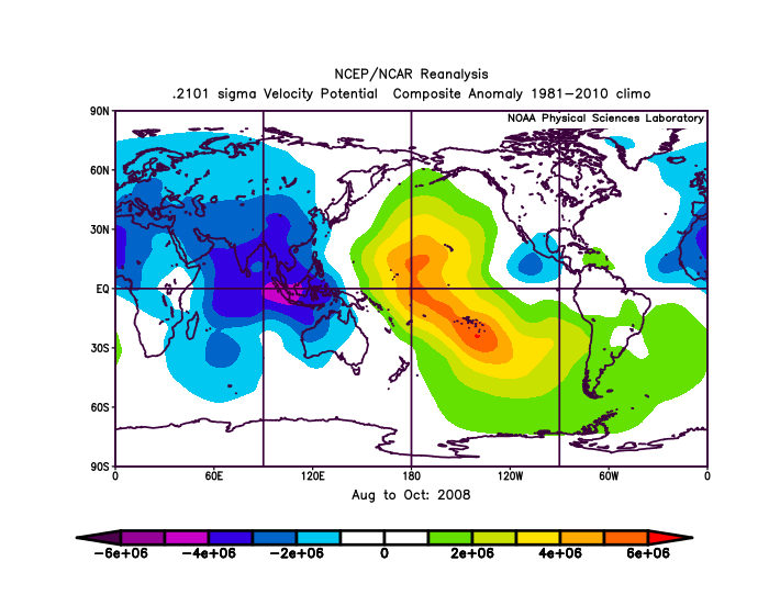
Was 2008 a year with a rising or sinking VP cell in the EPAC?
0 likes
Unless explicitly stated, all info in my posts is based on my own opinions and observations. Tropical storms and hurricanes can be extremely dangerous. Refer to an accredited weather research agency or meteorologist if you need to make serious decisions regarding an approaching storm.
-
AlphaToOmega
- Category 5
- Posts: 1448
- Joined: Sat Jun 26, 2021 10:51 am
- Location: Somewhere in Massachusetts
Re: 2021 Indicators: SST's / SAL / MSLP / Shear / Steering / Instability / Sat Images
Category5Kaiju wrote:Was 2008 a year with a rising or sinking VP cell in the EPAC?
Rising EPAC cell
0 likes
-
Category5Kaiju
- Category 5
- Posts: 4334
- Joined: Thu Dec 24, 2020 12:45 pm
- Location: Seattle and Phoenix
Re: 2021 Indicators: SST's / SAL / MSLP / Shear / Steering / Instability / Sat Images
AlphaToOmega wrote:Category5Kaiju wrote:Was 2008 a year with a rising or sinking VP cell in the EPAC?
Rising EPAC cell
https://i.postimg.cc/NfMfRYSg/Elcg2w-RN-Y.png
Yeah see this is why imho a rising or sinking EPAC cell alone does not really determine the fate of the Atlantic on how active it could truly get (especially if the cell rises but is weak). There's more to what separates a hyperactive year from a plain active year than just that, and I just don't know if we could really predict with 100% confidence all of such factors in advance.
4 likes
Unless explicitly stated, all info in my posts is based on my own opinions and observations. Tropical storms and hurricanes can be extremely dangerous. Refer to an accredited weather research agency or meteorologist if you need to make serious decisions regarding an approaching storm.
-
Deshaunrob17
- Tropical Storm

- Posts: 211
- Joined: Tue Aug 18, 2020 7:49 am
Re: 2021 Indicators: SST's / SAL / MSLP / Shear / Steering / Instability / Sat Images
cycloneye wrote:Papin has a interesting twist.
https://twitter.com/pppapin/status/1420762450811572226
That's q good point. A Tutt does not necessarily mean weak or low activity. A tropical cyclone that passes through the Atlantic Basin probably occupies <5 % of the entire Basin. Tutt could be present and there is still a major hurricane nearby.. The atmosphere is a fluid so everything moves. Just as hurricane moves, strengthens and weakness, Tutt moves, strengthens and weakens.. It's more complex than it looks!!!
Take for example Dorian strengthening into a Cat 1 near PR. Now I don t remember a Tutt, but I do remember heck amount of Sal, which was why the models we're never enthusiastic.. We all know how that ended up..
4 likes

Re: 2021 Indicators: SST's / SAL / MSLP / Shear / Steering / Instability / Sat Images
SFLcane wrote:So, Webb's plots show why the CFS and JMA are blasting the Atlantic with shear it’s basically all that WPAC activity has altered the Rossby wave pattern.
A Cat 2 typhoon and a couple of weak storms were able to make that amount of influence to the global weather pattern?
Do you have that plot?
2 likes
Irene '11 Sandy '12 Hermine '16 5/15/2018 Derecho Fay '20 Isaias '20 Elsa '21 Henri '21 Ida '21
I am only a meteorology enthusiast who knows a decent amount about tropical cyclones. Look to the professional mets, the NHC, or your local weather office for the best information.
I am only a meteorology enthusiast who knows a decent amount about tropical cyclones. Look to the professional mets, the NHC, or your local weather office for the best information.
-
Category5Kaiju
- Category 5
- Posts: 4334
- Joined: Thu Dec 24, 2020 12:45 pm
- Location: Seattle and Phoenix
Re: 2021 Indicators: SST's / SAL / MSLP / Shear / Steering / Instability / Sat Images
aspen wrote:SFLcane wrote:So, Webb's plots show why the CFS and JMA are blasting the Atlantic with shear it’s basically all that WPAC activity has altered the Rossby wave pattern.
A Cat 2 typhoon and a couple of weak storms were able to make that amount of influence to the global weather pattern?
Do you have that plot?
Yeah, I wholeheartedly agree. Because that seems quite interesting for that to be the case.
0 likes
Unless explicitly stated, all info in my posts is based on my own opinions and observations. Tropical storms and hurricanes can be extremely dangerous. Refer to an accredited weather research agency or meteorologist if you need to make serious decisions regarding an approaching storm.
-
tolakram
- Admin
- Posts: 20186
- Age: 62
- Joined: Sun Aug 27, 2006 8:23 pm
- Location: Florence, KY (name is Mark)
Re: 2021 Indicators: SST's / SAL / MSLP / Shear / Steering / Instability / Sat Images
About this time last year. Different year, but still cancel season. Rather than call out anyone, just review what was being said and determine if anything stands out as maybe spotting an indicator, or didn't matter at all. There's nothing wrong with being wrong, but I would hope that we all can learn year to year what to look for, and maybe what to ignore. This single page doesn't have any smoking guns, but it does have the familiar angst that conditions aren't perfect.
http://www.storm2k.org/phpbb2/viewtopic.php?f=31&t=120763&start=1940
I'm also trying to find the chatter just before Irma came through. A very large TUTT was dominant in the Caribbean until it wasn't.
http://www.storm2k.org/phpbb2/viewtopic.php?f=31&t=120763&start=1940
I'm also trying to find the chatter just before Irma came through. A very large TUTT was dominant in the Caribbean until it wasn't.
7 likes
M a r k
- - - - -
Join us in chat: Storm2K Chatroom Invite. Android and IOS apps also available.
The posts in this forum are NOT official forecasts and should not be used as such. Posts are NOT endorsed by any professional institution or STORM2K.org. For official information and forecasts, please refer to NHC and NWS products.
- - - - -
Join us in chat: Storm2K Chatroom Invite. Android and IOS apps also available.
The posts in this forum are NOT official forecasts and should not be used as such. Posts are NOT endorsed by any professional institution or STORM2K.org. For official information and forecasts, please refer to NHC and NWS products.
-
tolakram
- Admin
- Posts: 20186
- Age: 62
- Joined: Sun Aug 27, 2006 8:23 pm
- Location: Florence, KY (name is Mark)
Re: 2021 Indicators: SST's / SAL / MSLP / Shear / Steering / Instability / Sat Images
Ouch.
2017 indicators thread, Aug 7th: http://www.storm2k.org/phpbb2/viewtopic.php?f=31&t=118642&start=1240
Irma was a cat 3 by Sept 1st.
2017 indicators thread, Aug 7th: http://www.storm2k.org/phpbb2/viewtopic.php?f=31&t=118642&start=1240
Irma was a cat 3 by Sept 1st.
6 likes
M a r k
- - - - -
Join us in chat: Storm2K Chatroom Invite. Android and IOS apps also available.
The posts in this forum are NOT official forecasts and should not be used as such. Posts are NOT endorsed by any professional institution or STORM2K.org. For official information and forecasts, please refer to NHC and NWS products.
- - - - -
Join us in chat: Storm2K Chatroom Invite. Android and IOS apps also available.
The posts in this forum are NOT official forecasts and should not be used as such. Posts are NOT endorsed by any professional institution or STORM2K.org. For official information and forecasts, please refer to NHC and NWS products.
-
Category5Kaiju
- Category 5
- Posts: 4334
- Joined: Thu Dec 24, 2020 12:45 pm
- Location: Seattle and Phoenix
Re: 2021 Indicators: SST's / SAL / MSLP / Shear / Steering / Instability / Sat Images
tolakram wrote:About this time last year. Different year, but still cancel season. Rather than call out anyone, just review what was being said and determine if anything stands out as maybe spotting an indicator, or didn't matter at all. There's nothing wrong with being wrong, but I would hope that we all can learn year to year what to look for, and maybe what to ignore. This single page doesn't have any smoking guns, but it does have the familiar angst that conditions aren't perfect.
http://www.storm2k.org/phpbb2/viewtopic.php?f=31&t=120763&start=1940
I'm also trying to find the chatter just before Irma came through. A very large TUTT was dominant in the Caribbean until it wasn't.
Wasn't personally lurking on this forum back then, but yeah, you are absolutely right. It does seem like there's a general occasional pattern of some hurricane enthusiasts getting nervous that conditions may not be as conducive as expected for the Atlantic when in reality such worries did not really pan out to be legitimate worries. In the end, 2020 saw 30 NSs and did become a hyperactive season, contrary to what some talks at least at the time of your posted link to the 2020 indicators thread mentioned.
Edit: Just went through your link to the 2017 season; I personally did not know people were canceling the season in August of 2017 to that level, wow. What an unexpected turn.
Last edited by Category5Kaiju on Thu Jul 29, 2021 11:35 am, edited 1 time in total.
0 likes
Unless explicitly stated, all info in my posts is based on my own opinions and observations. Tropical storms and hurricanes can be extremely dangerous. Refer to an accredited weather research agency or meteorologist if you need to make serious decisions regarding an approaching storm.
-
AlphaToOmega
- Category 5
- Posts: 1448
- Joined: Sat Jun 26, 2021 10:51 am
- Location: Somewhere in Massachusetts
Re: 2021 Indicators: SST's / SAL / MSLP / Shear / Steering / Instability / Sat Images
Tolakram, it never stops! People try to use any lull of activity to "prove" that a season will be inactive. People try to cancel a season based on one run from one model. This happened even in 2020! The only way for a season to be cancel-proof is to have 5 major MDR hurricanes every month of the year.
0 likes
-
SFLcane
- S2K Supporter
- Posts: 10281
- Age: 48
- Joined: Sat Jun 05, 2010 1:44 pm
- Location: Lake Worth Florida
Re: 2021 Indicators: SST's / SAL / MSLP / Shear / Steering / Instability / Sat Images
aspen wrote:SFLcane wrote:So, Webb's plots show why the CFS and JMA are blasting the Atlantic with shear it’s basically all that WPAC activity has altered the Rossby wave pattern.
A Cat 2 typhoon and a couple of weak storms were able to make that amount of influence to the global weather pattern?
Do you have that plot?
https://twitter.com/webberweather/status/1420772727837892611
0 likes
-
USTropics
- Professional-Met

- Posts: 2738
- Joined: Sun Aug 12, 2007 3:45 am
- Location: Florida State University
Re: 2021 Indicators: SST's / SAL / MSLP / Shear / Steering / Instability / Sat Images
Shear is one of the most difficult parameters to forecast, even on an intermediate level (5-10) days. As such, skill level for seasonal shear forecasting is low, and a model blend is typically preferred. As an example, this was the shear forecast last year from the CFS for August and September:


Specifically for the Atlantic lead time weeks 1 and 2, the shear axis forecasted in the western Caribbean ended up being overestimated (and observed displaced more to the north over north GOM and CONUS). The CFS for lead time weeks 3 and 4 was also too aggressive on the prolonged TUTT axis extending into the Caribbean. Instead, we saw Marco and Laura form in the Caribbean.
Here was the CFS forecast for September and observed:


Forecast for lead time weeks 1 and 2 verified well, but again we can see the CFS overestimated wind shear in the Caribbean and most of the tropical Atlantic for lead time weeks 3 and 4.
You can find these types of archive graphics here - https://ncics.org/pub/mjo/archive/
Specifically for the Atlantic lead time weeks 1 and 2, the shear axis forecasted in the western Caribbean ended up being overestimated (and observed displaced more to the north over north GOM and CONUS). The CFS for lead time weeks 3 and 4 was also too aggressive on the prolonged TUTT axis extending into the Caribbean. Instead, we saw Marco and Laura form in the Caribbean.
Here was the CFS forecast for September and observed:
Forecast for lead time weeks 1 and 2 verified well, but again we can see the CFS overestimated wind shear in the Caribbean and most of the tropical Atlantic for lead time weeks 3 and 4.
You can find these types of archive graphics here - https://ncics.org/pub/mjo/archive/
9 likes
Re: 2021 Indicators: SST's / SAL / MSLP / Shear / Steering / Instability / Sat Images
The most articulate, alphabet soup-loaded dissertation is meaningless and of no value if it expires every few days and is replaced with another mess of jargon with a completely different outcome. Sometimes we're just too smart for our own good. As a simpleton...it's far easier to suggest this: The (real) storms will show up in the latter half of August and beyond because (drumroll....) they usually do. That's just the way it works and it's possible...but highly unlikely this year will be an exception.
9 likes
-
tolakram
- Admin
- Posts: 20186
- Age: 62
- Joined: Sun Aug 27, 2006 8:23 pm
- Location: Florence, KY (name is Mark)
Re: 2021 Indicators: SST's / SAL / MSLP / Shear / Steering / Instability / Sat Images
0 likes
M a r k
- - - - -
Join us in chat: Storm2K Chatroom Invite. Android and IOS apps also available.
The posts in this forum are NOT official forecasts and should not be used as such. Posts are NOT endorsed by any professional institution or STORM2K.org. For official information and forecasts, please refer to NHC and NWS products.
- - - - -
Join us in chat: Storm2K Chatroom Invite. Android and IOS apps also available.
The posts in this forum are NOT official forecasts and should not be used as such. Posts are NOT endorsed by any professional institution or STORM2K.org. For official information and forecasts, please refer to NHC and NWS products.
-
Category5Kaiju
- Category 5
- Posts: 4334
- Joined: Thu Dec 24, 2020 12:45 pm
- Location: Seattle and Phoenix
Re: 2021 Indicators: SST's / SAL / MSLP / Shear / Steering / Instability / Sat Images
psyclone wrote:The most articulate, alphabet soup-loaded dissertation is meaningless and of no value if it expires every few days and is replaced with another mess of jargon with a completely different outcome. Sometimes we're just too smart for our own good. As a simpleton...it's far easier to suggest this: The (real) storms will show up in the latter half of August and beyond because (drumroll....) they usually do. That's just the way it works and it's possible...but highly unlikely this year will be an exception.
Yep, sometimes it's best to keep things simple, and in this case, I expect activity to ramp up mid to late August. Unless I see otherwise or if reliable signs point otherwise as the time gets closer, I'm going to go with Occam's razor here and say that we should still expect an above average season starting later in August (with our first major forming by then as well, as many other seasons recently have shown).
0 likes
Unless explicitly stated, all info in my posts is based on my own opinions and observations. Tropical storms and hurricanes can be extremely dangerous. Refer to an accredited weather research agency or meteorologist if you need to make serious decisions regarding an approaching storm.
-
SFLcane
- S2K Supporter
- Posts: 10281
- Age: 48
- Joined: Sat Jun 05, 2010 1:44 pm
- Location: Lake Worth Florida
Re: 2021 Indicators: SST's / SAL / MSLP / Shear / Steering / Instability / Sat Images
Models are still adjusting.
0 likes
Who is online
Users browsing this forum: Google Adsense [Bot] and 316 guests