Well Defined Wave off African Coast
Moderator: S2k Moderators
Forum rules

The posts in this forum are NOT official forecasts and should not be used as such. They are just the opinion of the poster and may or may not be backed by sound meteorological data. They are NOT endorsed by any professional institution or STORM2K. For official information, please refer to products from the National Hurricane Center and National Weather Service.


-
cycloneye

- Admin

- Posts: 149276
- Age: 69
- Joined: Thu Oct 10, 2002 10:54 am
- Location: San Juan, Puerto Rico
Re:
wx247 wrote:What is the time frame that we are looking at before this arrives into the Atlantic?
Two days and it will emerge completly as its not moving very fast and when it does that,an invest will be tagged,same as when the disturbance that gave birth to Bertha.
0 likes
-
cycloneye
- Admin
- Posts: 149276
- Age: 69
- Joined: Thu Oct 10, 2002 10:54 am
- Location: San Juan, Puerto Rico
Re: Strong Wave inside Africa=Global Models show development
Here is the link for those who dont have dundee images of full disk pics like the one below.
http://www.sat.dundee.ac.uk/registerql.html
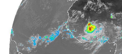
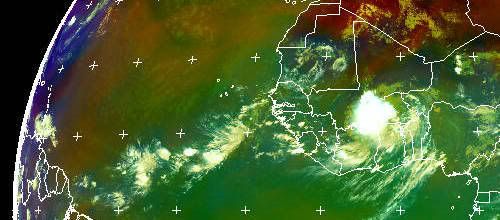
Here is the most recent pic at 12:00 UTC of Africa and look how well organized the system is.

http://www.sat.dundee.ac.uk/registerql.html
Here is the most recent pic at 12:00 UTC of Africa and look how well organized the system is.
0 likes
-
HurricaneHunter914
- Category 5

- Posts: 4439
- Age: 32
- Joined: Fri Mar 10, 2006 7:36 pm
- Location: College Station, TX


-
americanrebel
Re: Strong Wave inside Africa=Global Models show development
Amazing, that is the wave I was talking about, and now every model is jumping on it. I just got to laugh. LMAO
0 likes
-
cycloneye
- Admin
- Posts: 149276
- Age: 69
- Joined: Thu Oct 10, 2002 10:54 am
- Location: San Juan, Puerto Rico
Re: Strong Wave inside Africa=Global Models show development
12z GFS at 138 hours Weak Low passes 40w

http://www.nco.ncep.noaa.gov/pmb/nwprod ... n_180l.gif At 180 hours the low continues moving west and passes 50w.

At 300 hours,fishyland it ends up off the Carolinas:

http://www.nco.ncep.noaa.gov/pmb/nwprod ... n_180l.gif At 180 hours the low continues moving west and passes 50w.
At 300 hours,fishyland it ends up off the Carolinas:
0 likes
-
Extremeweatherguy

- Category 5
- Posts: 11095
- Joined: Mon Oct 10, 2005 8:13 pm
- Location: Florida
-
cycloneye
- Admin
- Posts: 149276
- Age: 69
- Joined: Thu Oct 10, 2002 10:54 am
- Location: San Juan, Puerto Rico
Re: Strong Wave inside Africa=Global Models show development
12z CMC continues to show it as a tropical storm.

Below is the 12z UKMET that continues to be in the parade of models with this.I notice that they have the track very far north than what sattelite suggests.
NEW TROPICAL STORM FORECAST TO DEVELOP AFTER 60 HOURS
FORECAST POSITION AT T+ 60 : 16.3N 17.8W
VERIFYING TIME POSITION STRENGTH TENDENCY
-------------- -------- -------- --------
00UTC 22.07.2008 16.3N 17.8W WEAK
12UTC 22.07.2008 16.2N 21.2W WEAK WEAKENING SLIGHTLY
00UTC 23.07.2008 15.9N 24.4W WEAK LITTLE CHANGE
12UTC 23.07.2008 15.6N 27.1W WEAK LITTLE CHANGE
00UTC 24.07.2008 15.7N 30.8W WEAK WEAKENING SLIGHTLY
12UTC 24.07.2008 15.5N 34.7W WEAK LITTLE CHANGE
00UTC 25.07.2008 15.7N 38.6W WEAK LITTLE CHANGE
12UTC 25.07.2008 16.7N 42.5W WEAK INTENSIFYING SLIGHTLY
0 likes
-
cycloneye
- Admin
- Posts: 149276
- Age: 69
- Joined: Thu Oct 10, 2002 10:54 am
- Location: San Juan, Puerto Rico
Re: Strong Wave inside Africa=Global Models show development
Wow,look at the 18:00 UTC pic.Incredible organization now.It looks much better than when the disturbance that gave birth to Bertha was in the same area.

To view this pic register for free here.
http://www.sat.dundee.ac.uk/registerql.html
To view this pic register for free here.
http://www.sat.dundee.ac.uk/registerql.html
0 likes

Re: Strong Wave inside Africa=Global Models show development
If this bares out, here comes hurricane Eduoard  Luckily most likely a fish,but holy Cow this month is active
0 likes


Re: Strong Wave inside Africa=Global Models show development
12Z EURO continues its Fish trend. This time it seems to be recurving much futher east.
http://www.ecmwf.int/products/forecasts ... 8071912!!/
12 GFS also wants a recurve this but much further west, right off NC.
http://www.nco.ncep.noaa.gov/pmb/nwprod ... n_312l.gif
The recurve scenarios are almost 200+ hrs out so way too early to know for sure. The image is impressive, it seems to have feeder bands to the south.
http://www.ecmwf.int/products/forecasts ... 8071912!!/
12 GFS also wants a recurve this but much further west, right off NC.
http://www.nco.ncep.noaa.gov/pmb/nwprod ... n_312l.gif
The recurve scenarios are almost 200+ hrs out so way too early to know for sure. The image
0 likes
-
cycloneye
- Admin
- Posts: 149276
- Age: 69
- Joined: Thu Oct 10, 2002 10:54 am
- Location: San Juan, Puerto Rico
Re: Strong Wave inside Africa=Global Models show development
Lets see when it puts its feet in the water how it evolves.
0 likes
Who is online
Users browsing this forum: No registered users and 226 guests