Gulf of Mexico (Is Invest 91L)
Moderator: S2k Moderators
Forum rules

The posts in this forum are NOT official forecasts and should not be used as such. They are just the opinion of the poster and may or may not be backed by sound meteorological data. They are NOT endorsed by any professional institution or STORM2K. For official information, please refer to products from the National Hurricane Center and National Weather Service.


-
canetracker

- S2K Supporter

- Posts: 751
- Age: 63
- Joined: Wed Jul 27, 2005 8:49 pm
- Location: Suburbia New Orleans...Harahan, LA
Re: Anyone else see this?
This probably won't amount to anything more than a rain maker but the current general probability seems to support that some type of development can happen.

Also, these animated buoys might be interesting to watch since the lowest area of pressure seems to be under the Fl. Panhandle:
http://www.pdfamily.com/weather/buoy/FLbuoy.php
Also, these animated buoys might be interesting to watch since the lowest area of pressure seems to be under the Fl. Panhandle:
http://www.pdfamily.com/weather/buoy/FLbuoy.php
0 likes

Re: Anyone else see this?
Sunday afternoon NWS Tampa Bay AFD:
FXUS62 KTBW 271732
AFDTBW
AREA FORECAST DISCUSSION
NATIONAL WEATHER SERVICE TAMPA BAY RUSKIN FL
132 PM EDT SUN JUL 27 2008
LONG TERM (TUESDAY NIGHT-SUNDAY)...PRETTY MUCH THE SAME DISCUSSION
AS YESTERDAY. HIGH PRESSURE RIDGE AXIS WILL REMAIN SOUTH OF THE
AREA...MEANING ONSHORE FLOW FOR US AND MORNING COASTAL SHOWERS
TRANSLATING INTO THE INTERIOR IN THE AFTERNOON. ONLY SUBTLE
DIFFERENCE WILL BE ALOFT WHERE GFS AND DGEX HAVE AN UPPER LOW
DEVELOPING OVER THE EASTERN OR CENTRAL GULF FOR THE WEEKEND. ECMWF
CARRIES THIS MORE AS A WEAKNESS THAN A LOW AND PREFER THAT SOLUTION
FOR NOW.
SHORT TERM/MARINE...NOAH
LONG TERM/AVIATION...SHARP
0 likes
-
srainhoutx

- S2K Supporter
- Posts: 6919
- Age: 68
- Joined: Sun Jan 14, 2007 11:34 am
- Location: Haywood County, NC
- Contact:
Re: Anyone else see this?
TWD...snipet...
TROPICAL WEATHER DISCUSSION
NWS TPC/NATIONAL HURRICANE CENTER MIAMI FL
205 PM EDT SUN JUL 27 2008
TROPICAL WEATHER DISCUSSION FOR NORTH AMERICA...CENTRAL
AMERICA...GULF OF MEXICO...CARIBBEAN SEA...NORTHERN SECTIONS
OF SOUTH AMERICA...AND ATLANTIC OCEAN TO THE AFRICAN COAST
FROM THE EQUATOR TO 32N. THE FOLLOWING INFORMATION IS BASED
ON SATELLITE IMAGERY...METEOROLOGICAL ANALYSIS...WEATHER
OBSERVATIONS...AND RADAR.
BASED ON 1200 UTC SURFACE ANALYSIS AND SATELLITE IMAGERY THROUGH
1715 UTC.
...DISCUSSION...
GULF OF MEXICO...
STRONG NE TO E MID TO UPPER LEVEL FLOW RESIDES ON THE SRN
PERIPHERY OF AN UPPER RIDGE CENTERED OVER W TEXAS AND SRN NEW
MEXICO. THIS UPPER FLOW LIES N OF 21N AND IS ADVECTING A FAIR
AMOUNT OF HIGH CLOUDINESS ACROSS THE NE AND NORTH CENTRAL GULF.
AT THE SURFACE A WEAK TROUGH EXTENDS FROM NORTH OF TALLAHASSEE
FLORIDA SW INTO THE NE GULF NEAR 28N87W. THIS FORCING MECHANISM
COUPLED WITH A DIFFLUENT PATTERN ALOFT IS GENERATING SCATTERED
SHOWERS AND TSTMS ACROSS THE GULF N OF 27N BETWEEN THE BIG BEND
OF FLORIDA TO 92W. ALSO SCATTERED SHOWERS AND ISOLATED TSTMS ARE
OVER THE FLORIDA KEYS EXTENDING SW INTO WRN PORTIONS OF THE
FLORIDA STRAITS. ELSEWHERE...A PAIR OF SURFACE HIGHS COVER THE
REMAINDER OF THE GULF W OF 92W WITH A 1016 MB HIGH CENTERED NEAR
27N91W AND A 1019 MB HIGH CENTERED NEAR VERACRUZ MEXICO. THESE
TWO ANTICYCLONIC CIRCULATIONS ARE ALLOWING WINDS TO BE LIGHT
VARIABLE ACROSS MUCH OF THE AREA.
http://www.nhc.noaa.gov/text/refresh/MI ... 1747.shtml?
0 likes

-
Dean4Storms
- S2K Supporter
- Posts: 6358
- Age: 63
- Joined: Sun Aug 31, 2003 1:01 pm
- Location: Miramar Bch. FL
Wow, that large MCS coming down this Sunday late afternoon through Mississippi might be the kicker if there is to be anything developing down there.
http://radar.weather.gov/radar.php?rid= ... 11&loop=no
http://radar.weather.gov/radar.php?rid= ... 11&loop=no
0 likes
-
gatorcane

- S2K Supporter
- Posts: 23708
- Age: 48
- Joined: Sun Mar 13, 2005 3:54 pm
- Location: Boca Raton, FL
Re: Anyone else see this?
The posts in this forum are NOT official forecast and should not be used as such. They are just the opinion of the poster and may or may not be backed by sound meteorological data. They are NOT endorsed by any professional institution or storm2k.org. For official information, please refer to the NHC and NWS products
I don't see any development in the GOM. The convection is unimpressive to me and the trough continues to weaken. The convection complex of Mississippi should fizzle out with the loss of daytime heating and scattered to light moderate convection should meander in the GOM in the overnight hours as we head towards a DMAX. Also, looking at climatology, the last week in July is not a big month for systems forming in the GOM. I was able to find only 2 systems within a 65 nautical mile radius of 27N, 87 W that developed in the last week of July (during the past 150 years).
I don't see any development in the GOM. The convection is unimpressive to me and the trough continues to weaken. The convection complex of Mississippi should fizzle out with the loss of daytime heating and scattered to light moderate convection should meander in the GOM in the overnight hours as we head towards a DMAX. Also, looking at climatology, the last week in July is not a big month for systems forming in the GOM. I was able to find only 2 systems within a 65 nautical mile radius of 27N, 87 W that developed in the last week of July (during the past 150 years).
0 likes

Re: Anyone else see this?
I'm only posting this because it's a little slow right now.
http://weather.jsums.edu/~mm5/animation ... 1_anm.html
Select domain 1
animation
sea level pressure
http://weather.jsums.edu/~mm5/animation ... 1_anm.html
Select domain 1
animation
sea level pressure
0 likes
Re: Anyone else see this?
I guess this strange development is what the GFS was forecasting four days earlier:
06Z, GFS, July 24, 2008:

06Z, GFS, July 24, 2008:
0 likes
Re: Anyone else see this?
I'm starting to notice 2 or 3 models showing a WEAK low drifting north or northwest from eastcentral GOM.


Not your most reliable models but.
Not your most reliable models but.
0 likes
-
deltadog03

- Professional-Met

- Posts: 3580
- Joined: Tue Jul 05, 2005 6:16 pm
- Location: Macon, GA
-
Smurfwicked
- Tropical Storm

- Posts: 164
- Age: 41
- Joined: Mon Sep 03, 2007 7:47 pm
- Location: SETX
Re: Anyone else see this?
Sure does look like it could turn into something to me, looking at the convection associated with it this morning. Looks too close to the coast to do anything if it intends on moving north or even NW for that matter. Any chance it'll take a route keeping it in the warm gulf waters for awhile?
0 likes

Re: Anyone else see this?
0 likes
-
Ed Mahmoud
Re: Anyone else see this?
I hope it drifts Westward. Temps in upper 90s, with abnormally low dewpoints and full sunshine are not a friend of my lawn or water bill.
I see a -70ºC pixel.
Not much else to watch...
I see a -70ºC pixel.
Not much else to watch...
0 likes

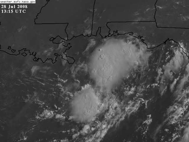
Re: Anyone else see this?
pressure are down about 2 mb on average over 24 hours and NW and SW winds are only about 50 miles apart...
This thing definely has a chance.
Morning visibles look like a area of low pressure cna form if we can get some sustained convection in where the winds are bening SW to NW...
This thing definely has a chance.
Morning visibles look like a area of low pressure cna form if we can get some sustained convection in where the winds are bening SW to NW...
0 likes

-
Ed Mahmoud
Re: Possible North GOM disturbance
In an area of weak steering currents. Especially near the surface. Mid level steering, if this is aloft and trying to work down, would be to the South, and then West, but again, pretty slow.
Latest CIMMS wind shear map is on summer holiday, but six hours ago, it was under Northerly shear, between 10 and 20 knots, not super favorable, but not really unfavorable either.

Latest CIMMS wind shear map is on summer holiday, but six hours ago, it was under Northerly shear, between 10 and 20 knots, not super favorable, but not really unfavorable either.
0 likes
Re: Possible North GOM disturbance
Twist near 27-87
While riding my bike I've seen strong shear pushing the thunderstorm tops way off lately.
While riding my bike I've seen strong shear pushing the thunderstorm tops way off lately.
0 likes
Who is online
Users browsing this forum: chaser1 and 55 guests