rock you think this has a legitimate chance of developing like the cmc and nogaps show?
im interested to see if the euro tonight jumps on board.
NW Caribbean development Wednesday?
Moderator: S2k Moderators
Forum rules

The posts in this forum are NOT official forecasts and should not be used as such. They are just the opinion of the poster and may or may not be backed by sound meteorological data. They are NOT endorsed by any professional institution or STORM2K. For official information, please refer to products from the National Hurricane Center and National Weather Service.
-
South Texas Storms

- Professional-Met

- Posts: 4246
- Joined: Thu Jun 24, 2010 12:28 am
- Location: Houston, TX
-
Stratosphere747
- Category 5

- Posts: 3772
- Joined: Thu Sep 11, 2003 8:34 pm
- Location: Surfside Beach/Freeport Tx
- Contact:
Re: NW Caribbean development Wednesday?
I meant to post this for y'all yesterday but was rather busy with the Karl chase.
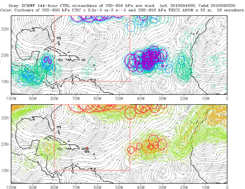
PREDICT 9/16 -
Other features of interest: In the wake of Karl, numerous global
model guidance products (0000 UTC ECMWF and EPS, 1200 UTC
Canadian/GFS) suggest that an elongated trough axis will become
established along about 12 N between 80-95 W. This feature
appears to develop in response to convergent lower tropospheric
flow associated with Karl-induced northerly flow through the gap
between the Bay of Campeche and the Gulf of Tehuantepec and
easterly flow induced by a weak disturbance in the Eastern
Pacific. While most model guidance products currently suggest
that any development will be slow to occur and likely in the
East Pacific rather than the Atlantic (e.g. image 19), there
often exists substantial temporal and spatial variability
between models and model forecast cycles with such events. This
is highlighted by the same ECMWF ensemble image above that shows
a few members nearing genesis criteria across the western
Caribbean Sea. Though this disturbance is on the western edge of
PREDICT's flight range, it bears close watching over the coming
days.
0 likes

Re: NW Caribbean development Wednesday?
South Texas Storms wrote:rock you think this has a legitimate chance of developing like the cmc and nogaps show?
im interested to see if the euro tonight jumps on board.
CMC is been good since they tweaked it....168 is really not that far away....if it keeps it for a few more runs then game on IMO.....
0 likes
-
South Texas Storms
- Professional-Met
- Posts: 4246
- Joined: Thu Jun 24, 2010 12:28 am
- Location: Houston, TX
Re: NW Caribbean development Wednesday?
yeah i agree a couple more runs showing this and count me in. i think this is another tex/mex threat imo. dont the forecasted steering layers support this at that time?
0 likes
-
somethingfunny

- ChatStaff

- Posts: 3926
- Age: 37
- Joined: Thu May 31, 2007 10:30 pm
- Location: McKinney, Texas
Re: NW Caribbean development Wednesday?
I saw a CMC run develop seven tropical cyclones in the first week of July this year. One of them became TD 2, the other six were ghosts.
Never ever ever ever trust the CMC for storm formation. Track and intensity are other things but I would only look at the CMC once a storm's already formed.
The NOGAPS of course has been suspect all year.
I know the ECMWF and GFS have been fooled a few times - Gaston and Hermine primarily - but I'll still be waiting on agreement from them before getting too interested in this one.
The posts in this forum are NOT official forecast and should not be used as such. They are just the opinion of the poster and may or may not be backed by sound meteorological data. They are NOT endorsed by any professional institution or storm2k.org. For official information, please refer to the NHC and NWS products.
Last edited by somethingfunny on Sat Sep 18, 2010 12:57 am, edited 1 time in total.
0 likes
I am not a meteorologist, and any posts made by me are not official forecasts or to be interpreted as being intelligent. These posts are just my opinions and are probably silly opinions.
Re: NW Caribbean development Wednesday?
South Texas Storms wrote:yeah i agree a couple more runs showing this and count me in. i think this is another tex/mex threat imo. dont the forecasted steering layers support this at that time?
well if your talking current steering yes,,,Karl got buried in the BOC.....but that will change. Still though 168hr is not that far from now...next weekend.....really need to watch down there now....
0 likes
-
Stratosphere747
- Category 5
- Posts: 3772
- Joined: Thu Sep 11, 2003 8:34 pm
- Location: Surfside Beach/Freeport Tx
- Contact:
Re: NW Caribbean development Wednesday?
Should have checked for the updated info. A few hours of sleep in almost three days causes the mind to be somewhat cloudy. 
The Euro ensembles show the favored area to be what we like to call the 'Carla Cradle' on Eastern. So I would suggest looking at this area for any development if it doesn't do so on the EPAC side. And yes a 'pouch' designation is right around the corner.
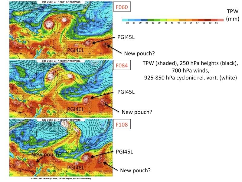
Possible southern Caribbean development: Both the GFS (not
shown) and the ECMWF deterministic forecasts (image 17) suggest
the potential for some development in the south Caribbean Sea
starting ~F072 in the GFS and ~F108 in the ECMWF. A spaghetti
plot of low-level circulation values for each member of the
ECMWF ensemble (image 15) also indicates the increasing
potential for pouch development with time, especially by F096
(0000 UTC 21 Sep) and F120 (0000 UTC 22 Sep).
The Euro ensembles show the favored area to be what we like to call the 'Carla Cradle' on Eastern. So I would suggest looking at this area for any development if it doesn't do so on the EPAC side. And yes a 'pouch' designation is right around the corner.
Possible southern Caribbean development: Both the GFS (not
shown) and the ECMWF deterministic forecasts (image 17) suggest
the potential for some development in the south Caribbean Sea
starting ~F072 in the GFS and ~F108 in the ECMWF. A spaghetti
plot of low-level circulation values for each member of the
ECMWF ensemble (image 15) also indicates the increasing
potential for pouch development with time, especially by F096
(0000 UTC 21 Sep) and F120 (0000 UTC 22 Sep).
0 likes
-
South Texas Storms
- Professional-Met
- Posts: 4246
- Joined: Thu Jun 24, 2010 12:28 am
- Location: Houston, TX
-
lonelymike
- S2K Supporter

- Posts: 634
- Joined: Sat Jul 26, 2008 10:12 am
- Location: walton county fla
Re: NW Caribbean development Wednesday?
CMC must be spinnin another ghost again. I mean Rock....the NOGAPS 


On a serious note I see your concern with the CMC being so close to home....hopefully it doesn't pan out.
On a serious note I see your concern with the CMC being so close to home....hopefully it doesn't pan out.
0 likes
GO SEMINOLES
-
ColinDelia

- S2K Supporter
- Posts: 918
- Joined: Mon Aug 29, 2005 5:52 am
- Location: The Beach, FL
Re: NW Caribbean development Wednesday?
850 mb snapshots from the 0z CMC
36 hours

48 hours

60 hours

36 hours
48 hours
60 hours
0 likes
-
wxman57

- Moderator-Pro Met

- Posts: 23120
- Age: 68
- Joined: Sat Jun 21, 2003 8:06 pm
- Location: Houston, TX (southwest)
Re: NW Caribbean development Wednesday?
I'm not sure if the CMC has been upgraded yet. The talk at the AMS meeting last spring was that they were hopeful that the upgrades might be ready by late September but more likely after that.
I do think that the good model consensus of a Caribbean development next weekend means that the models are seeing a major change in the pattern across the basin. The Gulf/Caribbean may be about to spring to life.
I do think that the good model consensus of a Caribbean development next weekend means that the models are seeing a major change in the pattern across the basin. The Gulf/Caribbean may be about to spring to life.
0 likes
This is the area most people feared/expected in a La nina and right on schedule in terms of the most likely area to generate a potential US hit and the models are all over it long term..
We now have support from all the globals of a developing cyclone over the western carribean in 8-10 days...Here's the canadian long range...
http://raleighwx.easternuswx.com/models ... cal228.gif
We now have support from all the globals of a developing cyclone over the western carribean in 8-10 days...Here's the canadian long range...
http://raleighwx.easternuswx.com/models ... cal228.gif
0 likes
-
Ivanhater

- Storm2k Moderator

- Posts: 11166
- Age: 39
- Joined: Fri Jul 01, 2005 8:25 am
- Location: Pensacola
Re: NW Caribbean development Wednesday?
No doubt about it wxman. The ensembles of the 3 big globals have been screaming for development. Not sure if we get 2 storms out of the Caribbean this week as the Canadian and nogaps show, but a sign nonetheless.
0 likes
Michael
-
Aquawind

- Category 5
- Posts: 6714
- Age: 62
- Joined: Mon Jun 16, 2003 10:41 pm
- Location: Salisbury, NC
- Contact:
0 likes
-
cycloneye

- Admin

- Posts: 148733
- Age: 69
- Joined: Thu Oct 10, 2002 10:54 am
- Location: San Juan, Puerto Rico
Re: NW Caribbean development Wednesday?
This is from the folks who do the new project of pouch to study the tropical waves.They briefly talk about the Caribbean area.
http://catalog.eol.ucar.edu/cgi-bin/pre ... opsis.html
The models continue to hint at a monsoonal development in
eastern Eastpac that moves northward over Mexico into the
western Caribbean ... with different results between the models.
While most models stall it in the southwestern Caribbean,
NOGAPS moves it northward along the east coast of Nicaragua.
http://catalog.eol.ucar.edu/cgi-bin/pre ... opsis.html
0 likes
Visit the Caribbean-Central America Weather Thread where you can find at first post web cams,radars
and observations from Caribbean basin members Click Here
and observations from Caribbean basin members Click Here
The pattern setting up is a classic one...In times of classic carribean development several features are often present.
1) Strong ridging develops along the eastern seaboard with a decent gradient setting up along the FL east coast for often times up to a week.
2) Pressures lower across the western carribean.
3)The **Monsoonal trough lifts North from panama.
4)T-waves move in from the eastern carribean which provide an additional spark to ignite genesis.
I've seen it many times in my 30+years of experience. As we head into fall these system evolve slowly but can often become large and dangerous. Usually they shoot the yucatan channel/western Cuba and head for the eastern Gulf/FL. From this point on expect all the globals to continue to zero in on this area. Should make for some interesting runs in the coming days long-range .
0 likes
-
srainhoutx

- S2K Supporter
- Posts: 6919
- Age: 68
- Joined: Sun Jan 14, 2007 11:34 am
- Location: Haywood County, NC
- Contact:
Re: NW Caribbean development Wednesday?
What you may be missing Aquawind, is what's also coming from the E in the Upper Levels.
0 likes
Carla/Alicia/Jerry(In The Eye)/Michelle/Charley/Ivan/Dennis/Katrina/Rita/Wilma/Ike/Harvey
Member: National Weather Association
Wx Infinity Forums
http://wxinfinity.com/index.php
Facebook.com/WeatherInfinity
Twitter @WeatherInfinity
Member: National Weather Association
Wx Infinity Forums
http://wxinfinity.com/index.php
Facebook.com/WeatherInfinity
Twitter @WeatherInfinity
-
Aquawind
- Category 5
- Posts: 6714
- Age: 62
- Joined: Mon Jun 16, 2003 10:41 pm
- Location: Salisbury, NC
- Contact:
Re: NW Caribbean development Wednesday?
srainhoutx wrote:What you may be missing Aquawind, is what's also coming from the E in the Upper Levels.
Please tell me what that is..ya teaser..lol
0 likes
-
srainhoutx
- S2K Supporter
- Posts: 6919
- Age: 68
- Joined: Sun Jan 14, 2007 11:34 am
- Location: Haywood County, NC
- Contact:
Re: NW Caribbean development Wednesday?
Stratosphere747 wrote:I meant to post this for y'all yesterday but was rather busy with the Karl chase.
PREDICT 9/16 -
Other features of interest: In the wake of Karl, numerous global
model guidance products (0000 UTC ECMWF and EPS, 1200 UTC
Canadian/GFS) suggest that an elongated trough axis will become
established along about 12 N between 80-95 W. This feature
appears to develop in response to convergent lower tropospheric
flow associated with Karl-induced northerly flow through the gap
between the Bay of Campeche and the Gulf of Tehuantepec and
easterly flow induced by a weak disturbance in the Eastern
Pacific. While most model guidance products currently suggest
that any development will be slow to occur and likely in the
East Pacific rather than the Atlantic (e.g. image 19), there
often exists substantial temporal and spatial variability
between models and model forecast cycles with such events. This
is highlighted by the same ECMWF ensemble image above that shows
a few members nearing genesis criteria across the western
Caribbean Sea. Though this disturbance is on the western edge of
PREDICT's flight range, it bears close watching over the coming
days.
Not so sure about the 'teaser' there Aquawind, as that is not my style. You can see from the quoted post by Stratosphere747, models are sniffing an area of cyclogenesis. After all this is Talkin Tropics and we all are interested in what may lie ahead. I do see a favorable mjo pulse and certainly the models are reacting to that.
0 likes
Carla/Alicia/Jerry(In The Eye)/Michelle/Charley/Ivan/Dennis/Katrina/Rita/Wilma/Ike/Harvey
Member: National Weather Association
Wx Infinity Forums
http://wxinfinity.com/index.php
Facebook.com/WeatherInfinity
Twitter @WeatherInfinity
Member: National Weather Association
Wx Infinity Forums
http://wxinfinity.com/index.php
Facebook.com/WeatherInfinity
Twitter @WeatherInfinity
Who is online
Users browsing this forum: NotAHurricane and 67 guests