Area of disturbed weather in SW Caribbean (Is invest 94L)
Moderator: S2k Moderators
Forum rules

The posts in this forum are NOT official forecasts and should not be used as such. They are just the opinion of the poster and may or may not be backed by sound meteorological data. They are NOT endorsed by any professional institution or STORM2K. For official information, please refer to products from the National Hurricane Center and National Weather Service.

Re: Global Model Runs Discussion
Well it looks like the 0z GFS decides to spin something up and sends it to Ivan's house..  ...of course from 72hrs to 324hr it basically moves at snails pace...doesnt seem realistic.
0 likes
Re: Global Model Runs Discussion
0 likes

Re: Area of disturbed weather in the SW Caribbean
TROPICAL WEATHER DISCUSSION
NWS NATIONAL HURRICANE CENTER MIAMI FL
805 AM EDT SUN MAY 29 2011
CARIBBEAN SEA...
AN UPPER LEVEL ANTI-CYCLONIC CIRCULATION SITS OVER THE CARIBBEAN
SEA AND NORTHERN SOUTH AMERICA THIS MORNING. THIS FLOW IS
KEEPING FAIR WEATHER CONDITIONS OVER MUCH OF THE CARIBBEAN...
EXCEPT FOR THE SW BASIN...WHERE BROAD SURFACE CYCLONIC TURNING
IS NOTED IN THIS REGION. LOW LEVEL MOISTURE REMAINS QUITE HIGH
IN THIS REGION...NOTICED ON TPW PRODUCT. SCATTERED SHOWERS AND
TSTMS ARE S OF 18N W OF 73W. WITHIN THIS AREA OF CONVECTION...A
SURFACE TROUGH IS ANALYZED FROM THE COAST OF COSTA RICA NEAR
10N83W NE TO 14N76W. MODEL GUIDANCE IS IN BETTER AGREEMENT
SUGGESTING THE ACTIVITY IN THE SW BASIN WILL INCREASE OVER THE
NEXT 24 HOURS...AS CYCLOGENESIS IN THE FORM OF A WEAK LOW
PRESSURE CENTER DEVELOPS IN THE 36 TO 72 HOUR WINDOW ACROSS THE
SW CARIBBEAN SEA WATERS.
0 likes

Re: Area of disturbed weather in the SW Caribbean
Brent wrote::sick:

Um...exact repeat of the last Arlene.
Not sure if something starting exactly the same as 2005 would be a good sign.
0 likes
-
srainhoutx

- S2K Supporter

- Posts: 6919
- Age: 68
- Joined: Sun Jan 14, 2007 11:34 am
- Location: Haywood County, NC
- Contact:
Re: Area of disturbed weather in the SW Caribbean
Large monsoonal low expected to develop would likely need some help from a rather strong tropical wave to offer much chance of consolidation. I just don't see that on the horizon right now, but something to watch none the less. Enjoy the remainder of the Memorial Day long weekend. 
0 likes
Carla/Alicia/Jerry(In The Eye)/Michelle/Charley/Ivan/Dennis/Katrina/Rita/Wilma/Ike/Harvey
Member: National Weather Association
Wx Infinity Forums
http://wxinfinity.com/index.php
Facebook.com/WeatherInfinity
Twitter @WeatherInfinity
Member: National Weather Association
Wx Infinity Forums
http://wxinfinity.com/index.php
Facebook.com/WeatherInfinity
Twitter @WeatherInfinity
-
Ivanhater

- Storm2k Moderator

- Posts: 11221
- Age: 39
- Joined: Fri Jul 01, 2005 8:25 am
- Location: Pensacola

Re: Area of disturbed weather in the SW Caribbean
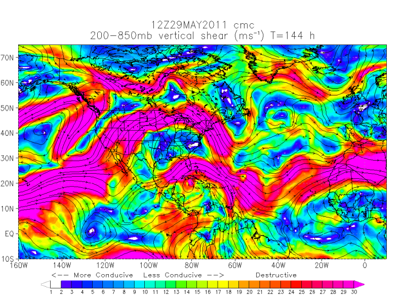
the GFS sits this down into carib from about 72hrs out to 300+....not realistic..but since its monsoon in orgin then maybe Steve you are right. Might take a long time to stack. Shear is not exactly ideal right now.
http://tropic.ssec.wisc.edu/real-time/w ... oom=&time=
http://tropic.ssec.wisc.edu/real-time/w ... oom=&time=
0 likes
Re: Area of disturbed weather in the SW Caribbean
now the 6z GFS seems a bit more realistic though it keeps it weak and buries it into Belize.....72hr to 232hr is a long time to hang around
http://tropic.ssec.wisc.edu/real-time/w ... oom=&time=
where is everyone? I feel so alone...
http://tropic.ssec.wisc.edu/real-time/w ... oom=&time=
where is everyone? I feel so alone...
0 likes
-
Dean4Storms
- S2K Supporter
- Posts: 6358
- Age: 63
- Joined: Sun Aug 31, 2003 1:01 pm
- Location: Miramar Bch. FL
-
TreasureIslandFLGal

- S2K Supporter
- Posts: 1584
- Age: 58
- Joined: Sun Aug 15, 2004 6:16 pm
- Location: Cancun, Mexico (northeast Yucatan coast)
Re: Area of disturbed weather in the SW Caribbean
Obviously folks are enjoying the weekend, as many of our regulars aren't lighting up the boards regarding what could be our first action of the season!
0 likes
Chrissy & Ligeia

Re: Area of disturbed weather in the SW Caribbean
Its 2 weeks out so there can't be much more to this than climatological probability.
I don't think they have an actual wave assigned to this yet.
Often there is a monsoon low down around the Panama region that gives us our first TD in the gulf.
Are the shear and low level surface pressures different this year?
I don't think they have an actual wave assigned to this yet.
Often there is a monsoon low down around the Panama region that gives us our first TD in the gulf.
Are the shear and low level surface pressures different this year?
0 likes
-
Rgv20

- S2K Supporter
- Posts: 2466
- Age: 39
- Joined: Wed Jan 05, 2011 5:42 pm
- Location: Edinburg/McAllen Tx
Re: Area of disturbed weather in the SW Caribbean
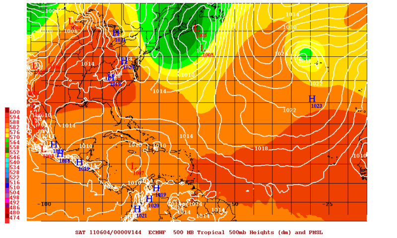
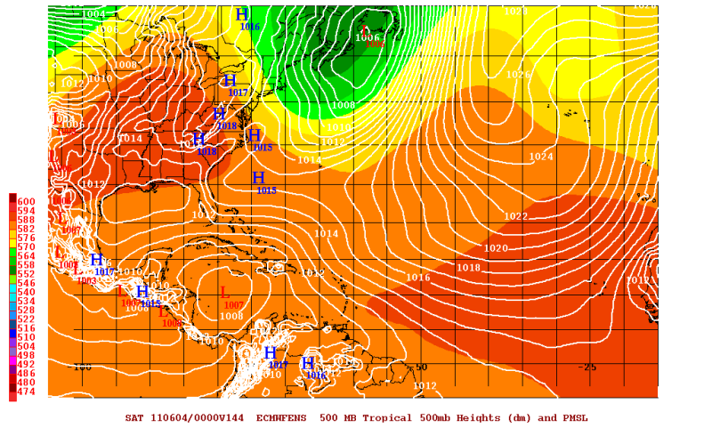
The Euro Ensembles favor the developing disturbance a bit more west than the operational Euro at 144 hrs out.
0 likes
The following post is NOT an official forecast and should not be used as such. It is just the opinion of the poster and may or may not be backed by sound meteorological data. It is NOT endorsed by any professional institution including storm2k.org For Official Information please refer to the NHC and NWS products.
-
CYCLONE MIKE
- Category 5

- Posts: 2183
- Joined: Tue Aug 31, 2004 6:04 pm
- Location: Gonzales, LA
Re: Area of disturbed weather in the SW Caribbean
I for one sure hope this develops into something and makes its way towards the north central gulf coast area, although very doubtful it will happen. A little off topic but we are in a drought in a very bad way right now. Had about .35 in of rain for may and not much more in april. Also the highs have been at or over 90 for weeks. This week we are forecast to reach the mid 90's with not a chance of rain and long range NWS is saying by the end of next week into next weekend we could see highs into the upper 90's -low 100's  . It is affecting my business and now my bank accounts. Sure hope we can get a little tropical action sometime in June.
. It is affecting my business and now my bank accounts. Sure hope we can get a little tropical action sometime in June.
0 likes
-
cycloneye

- Admin

- Posts: 149426
- Age: 69
- Joined: Thu Oct 10, 2002 10:54 am
- Location: San Juan, Puerto Rico
Re: Area of disturbed weather in the SW Caribbean
12z CMC is more bullish on this run.

0 likes
Visit the Caribbean-Central America Weather Thread where you can find at first post web cams,radars
and observations from Caribbean basin members Click Here
and observations from Caribbean basin members Click Here
-
Rgv20
- S2K Supporter
- Posts: 2466
- Age: 39
- Joined: Wed Jan 05, 2011 5:42 pm
- Location: Edinburg/McAllen Tx
0 likes
The following post is NOT an official forecast and should not be used as such. It is just the opinion of the poster and may or may not be backed by sound meteorological data. It is NOT endorsed by any professional institution including storm2k.org For Official Information please refer to the NHC and NWS products.

Re: Area of disturbed weather in the SW Caribbean
12Z GFS back to cranking it up the next 5 days but then weakening it as it slowly heads toward the southern gulf.
12Z GFS
Animated 12Z CMC
http://moe.met.fsu.edu/cgi-bin/cmctc2.cgi?time=2011052912&field=Sea+Level+Pressure&hour=Animation
12Z GFS
Animated 12Z CMC
http://moe.met.fsu.edu/cgi-bin/cmctc2.cgi?time=2011052912&field=Sea+Level+Pressure&hour=Animation
Last edited by ronjon on Sun May 29, 2011 12:32 pm, edited 1 time in total.
0 likes


-
Rgv20
- S2K Supporter
- Posts: 2466
- Age: 39
- Joined: Wed Jan 05, 2011 5:42 pm
- Location: Edinburg/McAllen Tx
I have no idea why the CMC would want to forecast a hurricane with all this wind shear or I'm I reading this map wrong??
0 likes
The following post is NOT an official forecast and should not be used as such. It is just the opinion of the poster and may or may not be backed by sound meteorological data. It is NOT endorsed by any professional institution including storm2k.org For Official Information please refer to the NHC and NWS products.

-
OuterBanker
- S2K Supporter
- Posts: 1761
- Joined: Wed Feb 26, 2003 10:53 am
- Location: Nags Head, NC
- Contact:
Re: Area of disturbed weather in the SW Caribbean
Hot darn, CMC hurricane number 1 of 150 for 2011.
It's always fun to watch the CMC, it develops everything. Swear it was designed by JB.
Reality is more like the euro. What does it say?
It's always fun to watch the CMC, it develops everything. Swear it was designed by JB.
Reality is more like the euro. What does it say?
0 likes
Who is online
Users browsing this forum: No registered users and 278 guests