Strong wave emerging Africa (Is Invest 93L)
Moderator: S2k Moderators
Forum rules

The posts in this forum are NOT official forecasts and should not be used as such. They are just the opinion of the poster and may or may not be backed by sound meteorological data. They are NOT endorsed by any professional institution or STORM2K. For official information, please refer to products from the National Hurricane Center and National Weather Service.

Strong 12z GFS thats for sure, thats a very worrying upper pattern, won't be gaining any latitude any time soon...
0 likes
Personal Forecast Disclaimer:
The posts in this forum are NOT official forecast and should not be used as such. They are just the opinion of the poster and may or may not be backed by sound meteorological data. They are NOT endorsed by any professional institution or storm2k.org. For official information, please refer to the NHC and NWS products
The posts in this forum are NOT official forecast and should not be used as such. They are just the opinion of the poster and may or may not be backed by sound meteorological data. They are NOT endorsed by any professional institution or storm2k.org. For official information, please refer to the NHC and NWS products
-
Hurricaneman

- Category 5

- Posts: 7404
- Age: 45
- Joined: Tue Aug 31, 2004 3:24 pm
- Location: central florida
Re:
KWT wrote:Strong 12z GFS thats for sure, thats a very worrying upper pattern, won't be gaining any latitude any time soon...
Maybe a NW tug at 50W but the ridge will show its muscle in this run, similar to Frances in 2004, but this is way out and could and probably will change
The posts in this forum are NOT official forecast and should not be used as such. They are just the opinion of the poster and may or may not be backed by sound meteorological data. They are NOT endorsed by any professional institution or storm2k.org. For official information, please refer to the NHC and NWS products
0 likes
Re: Strong wave over Africa (Pouch 13L)
On this run, the GFS sends a monster trough that breaks the ridge down and sends 13L right over Bermuda and then wants to send it close to Cape Cod
Last edited by caneseddy on Tue Aug 07, 2012 11:43 am, edited 1 time in total.
0 likes
-
Ivanhater

- Storm2k Moderator

- Posts: 11221
- Age: 39
- Joined: Fri Jul 01, 2005 8:25 am
- Location: Pensacola
Re: Strong wave over Africa (Pouch 13L)
caneseddy wrote:Recurve on this run...on this run, the GFS sends a monster trough that breaks the ridge down and sends it fishing right over Bermuda
Actually the high builds atop of it and send it toward the Eastern Seaboard
0 likes
Michael
Re: Strong wave over Africa (Pouch 13L)
Ivanhater wrote:caneseddy wrote:Recurve on this run...on this run, the GFS sends a monster trough that breaks the ridge down and sends it fishing right over Bermuda
Actually the high builds atop of it and send it toward the Eastern Seaboard
You are right but it looks like it will still miss the US.
And look what the GFS has coming off of Africa
0 likes
-
Riptide

- Category 2

- Posts: 753
- Age: 34
- Joined: Fri Jul 23, 2010 3:33 pm
- Location: Cape May, New Jersey
- Contact:
Re: Strong wave over Africa (Pouch 13L)
Ivanhater wrote:caneseddy wrote:Recurve on this run...on this run, the GFS sends a monster trough that breaks the ridge down and sends it fishing right over Bermuda
Actually the high builds atop of it and send it toward the Eastern Seaboard
It's a close call either way you look at it; no guarantee it will recurve or even affect the East Coast, could go south into the Carribean or into Florida. Even considering that it crosses into the Atlantic at a rather high laditude.
0 likes
Re: Strong wave over Africa (Pouch 13L)
Riptide wrote:Ivanhater wrote:caneseddy wrote:Recurve on this run...on this run, the GFS sends a monster trough that breaks the ridge down and sends it fishing right over Bermuda
Actually the high builds atop of it and send it toward the Eastern Seaboard
It's a close call either way you look at it; no guarantee it will recurve or even affect the East Coast, could go south into the Carribean or into Florida. Even considering that it crosses into the Atlantic at a rather high laditude.
For some reason, I'm not buying that huge break depicted at 252 hours...that would have to be a monster trough that breaks that ridge down, although I believe the 00z GFS or 06Z GFS depicted the monster trough coming down
Last edited by caneseddy on Tue Aug 07, 2012 11:48 am, edited 1 time in total.
0 likes
-
Ivanhater
- Storm2k Moderator
- Posts: 11221
- Age: 39
- Joined: Fri Jul 01, 2005 8:25 am
- Location: Pensacola
Re: Strong wave over Africa (Pouch 13L)
Oh yeah...looking at the pattern, the ridge wants to stay dominant...certainly a threat to the U.S
0 likes
Michael
Re: Strong wave over Africa (Pouch 13L)
Ivanhater wrote:Oh yeah...looking at the pattern, the ridge wants to stay dominant...certainly a threat to the U.S
Even though the GFS has been on point so far this season, I am wondering whether it is breaking that ridge down too soon like it usually does because like Michael said that ridge does not want to budge..we will know but as we know 252 hours is la-la-land
And the pattern that is forming reminds me of late August early September 2004 with a weak El Nino
The posts in this forum are NOT official forecast and should not be used as such. They are just the opinion of the poster and may or may not be backed by sound meteorological data. They are NOT endorsed by any professional institution or storm2k.org. For official information, please refer to the NHC and NWS products
0 likes
-
ConvergenceZone
.gif)
- Category 5
- Posts: 5241
- Joined: Fri Jul 29, 2005 1:40 am
- Location: Northern California
Re:
KWT wrote:I wouldn't be at all surprised if a large SAL outbreak came along with this wave, the upper high really strengthens and moves westwards with 13L by 96hrs, looks like a classic set-up for a SAL outbreak. Maybe why some models do little with this system.
We'll see though!
KWT! Don't see you much on the boards like in the past....Miss reading all your storm insights....
0 likes
-
ConvergenceZone
- Category 5
- Posts: 5241
- Joined: Fri Jul 29, 2005 1:40 am
- Location: Northern California
Re: Strong wave over Africa (Pouch 13L)
caneseddy wrote:Ivanhater wrote:Oh yeah...looking at the pattern, the ridge wants to stay dominant...certainly a threat to the U.S
Even though the GFS has been on point so far this season, I am wondering whether it is breaking that ridge down too soon like it usually does because like Michael said that ridge does not want to budge..we will know but as we know 252 hours is la-la-land
And the pattern that is forming reminds me of late August early September 2004 with a weak El Nino
The posts in this forum are NOT official forecast and should not be used as such. They are just the opinion of the poster and may or may not be backed by sound meteorological data. They are NOT endorsed by any professional institution or storm2k.org. For official information, please refer to the NHC and NWS products
I"m actually suprised there hasn't been more activity this yea.
It will be September before we know it...Is it normal to be only up to the
F storm by this time in August?
How many hurricanes have we had so far this year?? I forgot...
Last edited by ConvergenceZone on Tue Aug 07, 2012 12:02 pm, edited 1 time in total.
0 likes
-
Hurricaneman
- Category 5
- Posts: 7404
- Age: 45
- Joined: Tue Aug 31, 2004 3:24 pm
- Location: central florida
Re: Strong wave over Africa (Pouch 13L)
I wouldn't be suprised if this gets lemoned within the next 48 hrs due to having a low already and model support, and I wouldn't be suprised if this is invested in the next 72hrs if it can hang after splashdown
The posts in this forum are NOT official forecast and should not be used as such. They are just the opinion of the poster and may or may not be backed by sound meteorological data. They are NOT endorsed by any professional institution or storm2k.org. For official information, please refer to the NHC and NWS products
The posts in this forum are NOT official forecast and should not be used as such. They are just the opinion of the poster and may or may not be backed by sound meteorological data. They are NOT endorsed by any professional institution or storm2k.org. For official information, please refer to the NHC and NWS products
0 likes


Looking at the lastest (12Z) GFS run, it looks like the GFS initializes the wave as a 1006 mb low over central Mali, and has it emerge from the coast in 60 hours at about 18 north. However, the majority of the convection and apparent curvature associated with the wave is located over southwestern Mali and northern Ivory Coast, about 5 degrees to the south.
This is pretty academic for now, unless you live in West Africa, but it could have track implications if this pouch does end up becoming a TC.
This is pretty academic for now, unless you live in West Africa, but it could have track implications if this pouch does end up becoming a TC.
0 likes
-
bob rulz
- Category 5
- Posts: 1711
- Age: 36
- Joined: Sat Jan 28, 2006 7:30 pm
- Location: Salt Lake City, Utah
Re: Strong wave over Africa (Pouch 13L)
ConvergenceZone wrote:caneseddy wrote:Ivanhater wrote:Oh yeah...looking at the pattern, the ridge wants to stay dominant...certainly a threat to the U.S
Even though the GFS has been on point so far this season, I am wondering whether it is breaking that ridge down too soon like it usually does because like Michael said that ridge does not want to budge..we will know but as we know 252 hours is la-la-land
And the pattern that is forming reminds me of late August early September 2004 with a weak El Nino
The posts in this forum are NOT official forecast and should not be used as such. They are just the opinion of the poster and may or may not be backed by sound meteorological data. They are NOT endorsed by any professional institution or storm2k.org. For official information, please refer to the NHC and NWS products
I"m actually suprised there hasn't been more activity this yea.
It will be September before we know it...Is it normal to be only up to the
F storm by this time in August?
How many hurricanes have we had so far this year?? I forgot...
We are way ahead of schedule in terms of tropical storms. I think Florence was the 3rd or 4th-earliest F storm on record? Can't remember for sure.
Ernesto is only the 2nd hurricane so far though, which I think is pretty close to normal.
0 likes
-
cycloneye

- Admin

- Posts: 149479
- Age: 69
- Joined: Thu Oct 10, 2002 10:54 am
- Location: San Juan, Puerto Rico
Re: Strong wave over Africa (Pouch 13L)


http://www.weatherstreet.com/hurricane/ ... c-2012.htm
0 likes
Visit the Caribbean-Central America Weather Thread where you can find at first post web cams,radars
and observations from Caribbean basin members Click Here
and observations from Caribbean basin members Click Here

Nice first image from the new satellite MSG3.
http://www.eumetsat.int/groups/cps/documents/image/img_msg3_firstimage_120807.jpg
Warning large image.
http://www.eumetsat.int/groups/cps/documents/image/img_msg3_firstimage_120807.jpg
Warning large image.
0 likes
-
somethingfunny

- ChatStaff

- Posts: 3926
- Age: 37
- Joined: Thu May 31, 2007 10:30 pm
- Location: McKinney, Texas
Re: Strong wave over Africa (Pouch 13L)
Pouch 13L took a dive to the south, it's around 13°N now as opposed to 17°N yesterday. It might ride the ITCZ back north again as waves usually do, since the globals have mostly shown the system exiting Africa at around 17°N. It just seems wierd to me to have a system exit that far north; usually they have no chance when they exit Africa above 15°N.
Look at this thing spin, though.
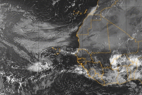
And, the real story on 92L is how it and ex-Florence are clearing out the SAL:

Look at this thing spin, though.
And, the real story on 92L is how it and ex-Florence are clearing out the SAL:
0 likes
I am not a meteorologist, and any posts made by me are not official forecasts or to be interpreted as being intelligent. These posts are just my opinions and are probably silly opinions.
-
somethingfunny
- ChatStaff
- Posts: 3926
- Age: 37
- Joined: Thu May 31, 2007 10:30 pm
- Location: McKinney, Texas
Re: Strong wave over Africa (Pouch 13L)
As I look at that Africa loop again I'm noticing the pouch has several circulations. The more obvious spin is the one with the convection of course, farther south where there's more moisture to play with. But there's another circulation crossing the border from southwestern Niger into Mali, firing up a few isolated thunderstorms over the Sahel as it does so. That circulation is north of 15°N. What's going on with this thing? I usually don't watch waves very closely while they're still in Africa, I'm trying to learn how they behave now.
0 likes
I am not a meteorologist, and any posts made by me are not official forecasts or to be interpreted as being intelligent. These posts are just my opinions and are probably silly opinions.
-
cycloneye
- Admin
- Posts: 149479
- Age: 69
- Joined: Thu Oct 10, 2002 10:54 am
- Location: San Juan, Puerto Rico
Re: Strong wave over Africa (Pouch 13L)
sf, here is one GFS ensemble member scenario on very long range.


0 likes
Visit the Caribbean-Central America Weather Thread where you can find at first post web cams,radars
and observations from Caribbean basin members Click Here
and observations from Caribbean basin members Click Here
-
SeminoleWind

- Category 1

- Posts: 359
- Age: 51
- Joined: Wed Jun 02, 2010 8:37 pm
- Location: Lake County Florida
0 likes
This post is NOT an official forecast and should not be used as such. It is just the opinion of the poster and may or may not be backed by sound meteorological data. It is NOT endorsed by any professional institution including storm2k.org For Official Information please refer to the NHC and NWS products.
Who is online
Users browsing this forum: No registered users and 160 guests