Tropical Wave (Pouch 12L) E Atlantic - (Is Invest 98L)
Moderator: S2k Moderators
Forum rules

The posts in this forum are NOT official forecasts and should not be used as such. They are just the opinion of the poster and may or may not be backed by sound meteorological data. They are NOT endorsed by any professional institution or STORM2K. For official information, please refer to products from the National Hurricane Center and National Weather Service.

-
cycloneye

- Admin

- Posts: 149469
- Age: 69
- Joined: Thu Oct 10, 2002 10:54 am
- Location: San Juan, Puerto Rico
Re:
RL3AO wrote:Is that the same wave cycloneye circled? 9 to 10 days to leave Africa seems too far out for where that wave is.
I think is not that one as the timing does not coincide. The next one behind will be the one.
0 likes
Visit the Caribbean-Central America Weather Thread where you can find at first post web cams,radars
and observations from Caribbean basin members Click Here
and observations from Caribbean basin members Click Here
-
cycloneye
- Admin
- Posts: 149469
- Age: 69
- Joined: Thu Oct 10, 2002 10:54 am
- Location: San Juan, Puerto Rico
Re: African "bear watch": E Atlantic development, 24-26 July?
The one now over Ethiopia.

0 likes
Visit the Caribbean-Central America Weather Thread where you can find at first post web cams,radars
and observations from Caribbean basin members Click Here
and observations from Caribbean basin members Click Here
-
gatorcane

- S2K Supporter

- Posts: 23708
- Age: 48
- Joined: Sun Mar 13, 2005 3:54 pm
- Location: Boca Raton, FL
Re: African "bear watch": E Atlantic development, 24-26 July?
MiamiensisWx wrote:Note: I am starting this thread separate from the models thread because the time frame and suspected system are rather concrete. I am looking at a possible cyclone developing in the 24-26 July time frame.
This is rather in the long range, but the agreement among the "reputable" models is surprisingly solid. The ECMWF, the GFS, and the GEFS (GFS ensembles?) all agree that the MJO will retrograde toward Phases 1/2 within the next week, with the reliable ECMWF leaning toward Phase 2. This causes enhanced environmental vorticity to develop as the African monsoonal jet (day eight and beyond) begins to expand west into the eastern Atlantic. In this time frame (probably 24-26 July, as the GFS is usually too fast with this kind of pattern shift), the ECMWF develops a split flow over Greenland and begins to hint at an MJO-induced pattern change, with the +NAO that has persisted for three months finally shifting into a neutral and then a likely -NAO regime heading into early August. This would tend to allow lower pressures and weaker trades in the MDR as the whole mid-level pattern retrogrades west: first the Bermuda High shifts west (retrogrades) toward the Southeast, then the trough over the East Coast moves inland into the Upper Midwest yet again. This not only means better conditions for Cape Verde development--reduced trades = weaker low-level shear, less stable air (=less of an inversion) in the mid-troposphere--but also signals an increased risk of landfalls with any Cape Verde system that does not recurve immediately. In fact, as early as 22 July, the GFS continues to indicate development with a tropical wave that moves off the African coast. Until today, the GFS had been showing this feature on an on-again, off-again basis, usually only to shunt the prospects back into the misty long range, but this time it has moved the time frame a bit closer; and while it is probably too rapid with development, its general idea is close in time frame to that of the more-reliable ECMWF, which shows a similar situation emerging. The general idea is that there is a chance that one of the tropical waves coming off W Africa may attempt to form in the 24-26 July time scale, when the pattern shift kicks in. I think this is worth watching because the long-range GFS has continuously brought this proposed system very far to the west, reaching the Caribbean in about two weeks. The upcoming pattern will support a westward track with any feature that develops in the MDR circa 24-26 July. This definitely bears watching as this potential system would impact the Caribbean by the first week of August, when seasonal conditions start to become more favorable than in July.
ECMWF long range
GFS day six
ECMWF MJO forecast
GEFS MJO forecast
Excellent analysis MiamiensisWx. Really enjoyed reading your thoughts.
We certainly need to start watching these African waves more closely now that we are moving into late July and into August.
0 likes
-
MiamiensisWx
Re: African "bear watch": E Atlantic development, 24-26 July?
Both the 06Z GFS and the 00Z ECMWF ensemble mean continue to depict development near 12°N 18°W (just off Conakry, Guinea) beginning on 25 July. (Note also that the time frame has moved closer, from beyond 204 hours to within 180-192 hours (days 7-8).) If the system were to form at that latitude and were to move west in its first two days, it would be far enough to the south so as to pose a potential threat to the islands and/or the East Coast in the long range. However, if the system were to form and/or pass north of 12°N in its first two days, the chance of landfall, aside from impacts to the Cape Verde islands, would be very low, as all known July systems to have formed at such a latitude--so far east--have recurved out to sea. But of course, we need to see an actual cyclone first before we can speculate as to track.
06Z GFS:

00Z ECMWF ensemble mean:

06Z GFS:
00Z ECMWF ensemble mean:
0 likes
-
MiamiensisWx
Re: African "bear watch": E Atlantic development, 24-26 July?
The 12Z operational GFS depicts a slower wave axis that does reach the W African coast until 18Z on 25 July. Development is thus delayed until early on 26 July. Still, the system is still visible on the run.

0 likes
-
SouthFloridawx

- S2K Supporter
- Posts: 8346
- Age: 47
- Joined: Tue Jul 26, 2005 1:16 am
- Location: Sarasota, FL
- Contact:
Re: African "bear watch": E Atlantic development, 24-26 July?
You can definitely still see it on the 850mb Vorticity.

0 likes
-
gatorcane
- S2K Supporter
- Posts: 23708
- Age: 48
- Joined: Sun Mar 13, 2005 3:54 pm
- Location: Boca Raton, FL
Today's 12Z CMC also shows the low, here we are at 222 hours with low in tact just SE of the Cape Verde islands but the low emerges from Africa around the same time the ECWMF and GFS are showing it emerge (around 180 hours from now):

Here is today's 12Z ECMWF at 240 hours showing the low pressure just southwest of the Cape Verde islands:

Here is today's 12Z ECMWF at 240 hours showing the low pressure just southwest of the Cape Verde islands:
0 likes
-
MiamiensisWx

-
Hurricane Alexis

- Category 2

- Posts: 683
- Age: 29
- Joined: Thu Jun 14, 2012 7:59 pm
- Location: Miami,Florida

0 likes
Personal Forecast Disclaimer:
The posts in this forum are NOT official forecast and should not be used as such. They are just the opinion of the poster and may or may not be backed by sound meteorological data. They are NOT endorsed by any professional institution or storm2k.org. For official information, please refer to the NHC and NWS products.
The posts in this forum are NOT official forecast and should not be used as such. They are just the opinion of the poster and may or may not be backed by sound meteorological data. They are NOT endorsed by any professional institution or storm2k.org. For official information, please refer to the NHC and NWS products.
-
OuterBanker
- S2K Supporter
- Posts: 1761
- Joined: Wed Feb 26, 2003 10:53 am
- Location: Nags Head, NC
- Contact:
Re:
Hurricane Alexis wrote:00z GFS develops the wave ahead of it into a TS by July 26.
Uploaded with ImageShack.us
To heck with the 1008 low in central Atlantic, how about the 989 in the Great Lakes
0 likes

-
tolakram
- Admin
- Posts: 20185
- Age: 62
- Joined: Sun Aug 27, 2006 8:23 pm
- Location: Florence, KY (name is Mark)
Re: African "bear watch": E Atlantic development, 26-28 July?
I don't see any models predicting development in 10 days. Each has either pushed back beyond 10 days or dropped it all together. Even the 850 vorticity now shows a couple of red areas either dissipating or not strengthening. In my opinion we should concentrate on posting in the global models thread and let this one go. 
0 likes
M a r k
- - - - -
Join us in chat: Storm2K Chatroom Invite. Android and IOS apps also available.
The posts in this forum are NOT official forecasts and should not be used as such. Posts are NOT endorsed by any professional institution or STORM2K.org. For official information and forecasts, please refer to NHC and NWS products.
-
HurricaneTracker2031
- Tropical Storm

- Posts: 248
- Age: 26
- Joined: Fri Jul 19, 2013 7:20 pm
- Location: Pembroke Pines, FL, USA
- Contact:
Re:
Hurricane Alexis wrote:00z GFS develops the wave ahead of it into a TS by July 26.
Uploaded with ImageShack.us
Interesting 192hrs has it making landfall.

0 likes
SHORT VERSION OF DISCLAIMER: THIS SITE LINK BELOW IS NOT AN OFFICIAL FORECASTING OFFICE AND SHOULD NOT BE USED TO MAKE ANY EMERGENCY DECISIONS....
http://www.macstropicalweather.weebly.com
http://www.macstropicalweather.weebly.com
-
beoumont

- Category 1

- Posts: 473
- Joined: Sun Jul 10, 2011 4:13 pm
- Location: East Central Florida
- Contact:
Re: African "bear watch": E Atlantic development, 26-28 July?
tolakram wrote:I don't see any models predicting development in 10 days. Each has either pushed back beyond 10 days or dropped it all together. Even the 850 vorticity now shows a couple of red areas either dissipating or not strengthening.
Just as likely that a long rang model (GFS, etc) shows tropical cyclone genesis on day 6 or 7 or day 15, and it doesn't verify---actual genesis occurs on day 6 or 7 or 15 when these models do not show any development.
Wish maps are wish maps. It is a fun sport, looking at these long range maps, that I play as well; but I have absolutely no confidence in their abilities to predict or not predict tropical cyclone genesis after day 4. And even that is pushing it. "Tropical cyclone development is not expected during the next 48 hrs."
As the road sign along Card Sound in the Florida Keys notes:

0 likes
List of 79 tropical cyclones intercepted by Richard Horodner:
http://www.canebeard.com/page/page/572246.htm
http://www.canebeard.com/page/page/572246.htm

The name of this thread could be changed soon if the GFS is correct, we could see development as early as the 23-24th by the CV Islands and for a Tropical System of some sort to threaten the Lesser Antilles by next weekend. The 0z GFS run makes it 3 runs in a row.
The latest 0z GEM/GEM agrees with the GFS's timeframe for development.
The latest 0z GEM/GEM agrees with the GFS's timeframe for development.
0 likes
-
cycloneye
- Admin
- Posts: 149469
- Age: 69
- Joined: Thu Oct 10, 2002 10:54 am
- Location: San Juan, Puerto Rico
Re: African "bear watch": E Atlantic development?
06z continues with the development.


0 likes
Visit the Caribbean-Central America Weather Thread where you can find at first post web cams,radars
and observations from Caribbean basin members Click Here
and observations from Caribbean basin members Click Here
Re: African "bear watch": E Atlantic development?
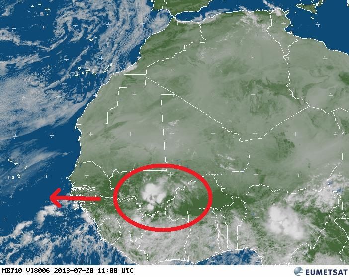
Here is the tropical wave in Africa that the GFS and Canadian models develop in a few days south or SW of the CV Islands.
0 likes
-
cycloneye
- Admin
- Posts: 149469
- Age: 69
- Joined: Thu Oct 10, 2002 10:54 am
- Location: San Juan, Puerto Rico
Re: African "bear watch": E Atlantic development?
NDG wrote:Here is the tropical wave in Africa that the GFS and Canadian models develop in a few days south or SW of the CV Islands.
http://i20.photobucket.com/albums/b245/ ... e4de12.jpg
The cluster behind looks better than what you circled. IMO,that one may be it.
0 likes
Visit the Caribbean-Central America Weather Thread where you can find at first post web cams,radars
and observations from Caribbean basin members Click Here
and observations from Caribbean basin members Click Here
Who is online
Users browsing this forum: No registered users and 233 guests