Interesting Feature Off the East Coast of Florida

This is the general tropical discussion area. Anyone can take their shot at predicting a storms path.

Moderator: S2k Moderators

Forum rules

The posts in this forum are NOT official forecasts and should not be used as such. They are just the opinion of the poster and may or may not be backed by sound meteorological data. They are NOT endorsed by any professional institution or STORM2K. For official information, please refer to products from the National Hurricane Center and National Weather Service.

Help Support Storm2K
Message
Author
User avatar
NDG
S2K Supporter
S2K Supporter
Posts: 15446
Joined: Sun Jul 09, 2006 10:14 pm
Location: Orlando, FL

Re: Interesting Feature Off the East Coast of Florida

#21 Postby NDG » Thu Jun 19, 2014 10:43 am

Saved radar loop:

Image
Image
0 likes   

User avatar
wxman57
Moderator-Pro Met
Moderator-Pro Met
Posts: 22979
Age: 67
Joined: Sat Jun 21, 2003 8:06 pm
Location: Houston, TX (southwest)

Re: Interesting Feature Off the East Coast of Florida

#22 Postby wxman57 » Thu Jun 19, 2014 10:54 am

There's a buoy right in the middle of the squalls reporting a pressure of 1021.6mb and rising. Surface obs do not indicate any rotation at all. It's clearly a mid-level feature. Something to watch if convection persists, though.
0 likes   

User avatar
NDG
S2K Supporter
S2K Supporter
Posts: 15446
Joined: Sun Jul 09, 2006 10:14 pm
Location: Orlando, FL

#23 Postby NDG » Thu Jun 19, 2014 10:54 am

This morning I see a little better reflection of the vorticity at the surface, but surface pressures remain very high and have not fallen from 24 hrs ago.
0 likes   

User avatar
northjaxpro
S2K Supporter
S2K Supporter
Posts: 8900
Joined: Mon Sep 27, 2010 11:21 am
Location: Jacksonville, FL

#24 Postby northjaxpro » Thu Jun 19, 2014 10:58 am

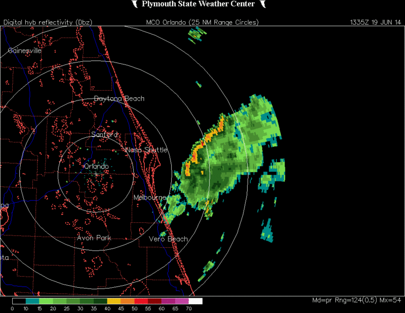
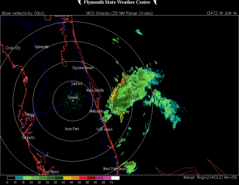
Yeah, wxman57, I made a mention yesterday as to the high surface pressures in the area. But, definitely, there is a decent concentrated area of convection just off the Cape. As you mentioned, if the convection can sustain itself and fester near the Gulf Stream, there is a slim chance that a surface reflection could be achieved, albeit it would likely be a weak one should that occur.
0 likes   
NEVER, EVER SAY NEVER in the tropics and weather in general, and most importantly, with life itself!!

________________________________________________________________________________________

Fay 2008 Beryl 2012 Debby 2012 Colin 2016 Hermine 2016 Julia 2016 Matthew 2016 Irma 2017 Dorian 2019

User avatar
NDG
S2K Supporter
S2K Supporter
Posts: 15446
Joined: Sun Jul 09, 2006 10:14 pm
Location: Orlando, FL

#25 Postby NDG » Thu Jun 19, 2014 11:32 am

Local Mesoscale Forecast Model (WRF) from Melbourne:

http://www.srh.noaa.gov/mlb/wrf/arw9_hires_sfc_wnd.php
0 likes   

Dean4Storms
S2K Supporter
S2K Supporter
Posts: 6358
Age: 62
Joined: Sun Aug 31, 2003 1:01 pm
Location: Miramar Bch. FL

Re: Interesting Feature Off the East Coast of Florida

#26 Postby Dean4Storms » Thu Jun 19, 2014 11:39 am

There is also some weak mid-level turning with that area over the eastern Gulf.

http://radar.weather.gov/ridge/radar.php?product=N0Z&rid=TBW&loop=yes
0 likes   

User avatar
Weatherboy1
Category 5
Category 5
Posts: 1189
Age: 49
Joined: Mon Jul 05, 2004 1:50 pm
Location: Jupiter/Sarasota, FL

#27 Postby Weatherboy1 » Thu Jun 19, 2014 11:46 am

Sure looks more interesting today than it did yesterday. We've seen a lot of swirls turn into low pressure areas and low-end TD/TS systems this time of year ... in this general area ... over the past several seasons. So maybe this will get its act together too!
0 likes   

CrazyC83
Professional-Met
Professional-Met
Posts: 34002
Joined: Tue Mar 07, 2006 11:57 pm
Location: Deep South, for the first time!

#28 Postby CrazyC83 » Thu Jun 19, 2014 12:34 pm

Convectively it looks good, but agreed there doesn't appear to be a surface low.
0 likes   

User avatar
northjaxpro
S2K Supporter
S2K Supporter
Posts: 8900
Joined: Mon Sep 27, 2010 11:21 am
Location: Jacksonville, FL

#29 Postby northjaxpro » Thu Jun 19, 2014 12:46 pm

NHC finally gives this a yellow circle, but virtually nil chance at developing anytime soon:

For the North Atlantic...Caribbean Sea and the Gulf of Mexico:

A surface trough located about 75 miles east of the east-central
coast of Florida is producing an area of disorganized showers and
thunderstorms. Surface pressures are relatively high in the region
and significant development of this system is not expected as it
drifts slowly northward during the next day or so. After that time,
conditions will remain unfavorable for development as the
disturbance accelerates northeastward ahead of an upper-level
trough.

Formation chance through 48 hours...low...near 0 percent.
* Formation chance through 5 days...low...near 0 percent.

$$
0 likes   
NEVER, EVER SAY NEVER in the tropics and weather in general, and most importantly, with life itself!!

________________________________________________________________________________________

Fay 2008 Beryl 2012 Debby 2012 Colin 2016 Hermine 2016 Julia 2016 Matthew 2016 Irma 2017 Dorian 2019

User avatar
gatorcane
S2K Supporter
S2K Supporter
Posts: 23691
Age: 47
Joined: Sun Mar 13, 2005 3:54 pm
Location: Boca Raton, FL

#30 Postby gatorcane » Thu Jun 19, 2014 2:28 pm

Saved images for surface pressure and low-level windflow. Surface pressure is relatively high at 1020MB. Windflow suggests the feature is at the low-levels with westerly wind vectors off the coast of the Melbourne area

Image

Image
0 likes   

User avatar
wxman57
Moderator-Pro Met
Moderator-Pro Met
Posts: 22979
Age: 67
Joined: Sat Jun 21, 2003 8:06 pm
Location: Houston, TX (southwest)

Re: Interesting Feature Off the East Coast of Florida

#31 Postby wxman57 » Thu Jun 19, 2014 3:47 pm

Weak LLC is appearing on offshore obs. Central pressure around 1019mb. Disturbance should track slowly northward for 36-48hrs then run into an approaching upper-level trof and its associated strong wind shear. That should tear it apart and shoot its remnants out to sea to the NE.
0 likes   

tolakram
Admin
Admin
Posts: 20009
Age: 62
Joined: Sun Aug 27, 2006 8:23 pm
Location: Florence, KY (name is Mark)

Re: Interesting Feature Off the East Coast of Florida

#32 Postby tolakram » Thu Jun 19, 2014 6:46 pm

Up to 10%

ZCZC MIATWOAT ALL
TTAA00 KNHC DDHHMM CCA

TROPICAL WEATHER OUTLOOK...CORRECTED
NWS NATIONAL HURRICANE CENTER MIAMI FL
800 PM EDT THU JUN 19 2014

Corrected formation chance through 5 days to 10 percent

For the North Atlantic...Caribbean Sea and the Gulf of Mexico:

1. A weak low pressure area located about 75 miles east of the
east-central coast of Florida is producing disorganized showers and
thunderstorms. Significant development of this system is not
expected while it drifts slowly northward during the next day or
so. After that time, conditions should remain unfavorable for
development while the disturbance accelerates northeastward.
* Formation chance through 48 hours...low...near 10 percent.
* Formation chance through 5 days...low...near 10 percent.

Forecaster Pasch
0 likes   
M a r k
- - - - -
Join us in chat: Storm2K Chatroom Invite. Android and IOS apps also available.

The posts in this forum are NOT official forecasts and should not be used as such. Posts are NOT endorsed by any professional institution or STORM2K.org. For official information and forecasts, please refer to NHC and NWS products.

tolakram
Admin
Admin
Posts: 20009
Age: 62
Joined: Sun Aug 27, 2006 8:23 pm
Location: Florence, KY (name is Mark)

Re: Interesting Feature Off the East Coast of Florida

#33 Postby tolakram » Thu Jun 19, 2014 6:50 pm

0 likes   
M a r k
- - - - -
Join us in chat: Storm2K Chatroom Invite. Android and IOS apps also available.

The posts in this forum are NOT official forecasts and should not be used as such. Posts are NOT endorsed by any professional institution or STORM2K.org. For official information and forecasts, please refer to NHC and NWS products.

User avatar
CFLHurricane
Category 1
Category 1
Posts: 346
Joined: Thu Mar 27, 2014 5:56 pm
Location: Floriduh

Re: Interesting Feature Off the East Coast of Florida (10%)

#34 Postby CFLHurricane » Thu Jun 19, 2014 9:39 pm

Well I guess this is better than the nothing burger we've gotten so far.

C'mon hurricane season- heat up already!


:onfire: :raincloud:
0 likes   
I'm not a meteorologist, but I did stay at a motel 8.

tolakram
Admin
Admin
Posts: 20009
Age: 62
Joined: Sun Aug 27, 2006 8:23 pm
Location: Florence, KY (name is Mark)

Re: Interesting Feature Off the East Coast of Florida (10%)

#35 Postby tolakram » Fri Jun 20, 2014 8:05 am

0 likes   
M a r k
- - - - -
Join us in chat: Storm2K Chatroom Invite. Android and IOS apps also available.

The posts in this forum are NOT official forecasts and should not be used as such. Posts are NOT endorsed by any professional institution or STORM2K.org. For official information and forecasts, please refer to NHC and NWS products.

tolakram
Admin
Admin
Posts: 20009
Age: 62
Joined: Sun Aug 27, 2006 8:23 pm
Location: Florence, KY (name is Mark)

Re: Interesting Feature Off the East Coast of Florida (10%)

#36 Postby tolakram » Fri Jun 20, 2014 8:09 am

Saved loop

Image
0 likes   
M a r k
- - - - -
Join us in chat: Storm2K Chatroom Invite. Android and IOS apps also available.

The posts in this forum are NOT official forecasts and should not be used as such. Posts are NOT endorsed by any professional institution or STORM2K.org. For official information and forecasts, please refer to NHC and NWS products.

CrazyC83
Professional-Met
Professional-Met
Posts: 34002
Joined: Tue Mar 07, 2006 11:57 pm
Location: Deep South, for the first time!

#37 Postby CrazyC83 » Fri Jun 20, 2014 9:12 am

For 2014, it doesn't look too bad.
0 likes   

tolakram
Admin
Admin
Posts: 20009
Age: 62
Joined: Sun Aug 27, 2006 8:23 pm
Location: Florence, KY (name is Mark)

Re: Interesting Feature Off the East Coast of Florida (10%)

#38 Postby tolakram » Fri Jun 20, 2014 12:07 pm

Naked swirl.

Image
0 likes   
M a r k
- - - - -
Join us in chat: Storm2K Chatroom Invite. Android and IOS apps also available.

The posts in this forum are NOT official forecasts and should not be used as such. Posts are NOT endorsed by any professional institution or STORM2K.org. For official information and forecasts, please refer to NHC and NWS products.

User avatar
northjaxpro
S2K Supporter
S2K Supporter
Posts: 8900
Joined: Mon Sep 27, 2010 11:21 am
Location: Jacksonville, FL

#39 Postby northjaxpro » Fri Jun 20, 2014 12:44 pm

Yeah, dry air and increasing wind shear ahead of an approaching upper trough sealed this system's fate from the very beginning. I am amazed though that this feature did manage to acquire a surface reflection, albeit a very weak one.

:uarrow: Also, nice satellite view of the seabreeze front, showing nicely making it just inland from Jax south down to about the Cape.
0 likes   
NEVER, EVER SAY NEVER in the tropics and weather in general, and most importantly, with life itself!!

________________________________________________________________________________________

Fay 2008 Beryl 2012 Debby 2012 Colin 2016 Hermine 2016 Julia 2016 Matthew 2016 Irma 2017 Dorian 2019

HurricaneTracker2031
Tropical Storm
Tropical Storm
Posts: 248
Age: 25
Joined: Fri Jul 19, 2013 7:20 pm
Location: Pembroke Pines, FL, USA
Contact:

Re: Interesting Feature Off the East Coast of Florida (10%)

#40 Postby HurricaneTracker2031 » Fri Jun 20, 2014 4:09 pm

My local coverage on the area off the coast of Florida. http://goo.gl/UOdG4b

It is dissipating... However, it is bring some heavy rain to Central Florida... What do all of you think?


The posts in this forum are NOT official forecast and should not be used as such. They are just the opinion of the poster and may or may not be backed by sound meteorological data. They are NOT endorsed by any professional institution or storm2k.org. For official information, please refer to the NHC and NWS products.
0 likes   
SHORT VERSION OF DISCLAIMER: THIS SITE LINK BELOW IS NOT AN OFFICIAL FORECASTING OFFICE AND SHOULD NOT BE USED TO MAKE ANY EMERGENCY DECISIONS....

http://www.macstropicalweather.weebly.com


Return to “Talkin' Tropics”

Who is online

Users browsing this forum: riapal, Stormlover70, Zeta and 45 guests