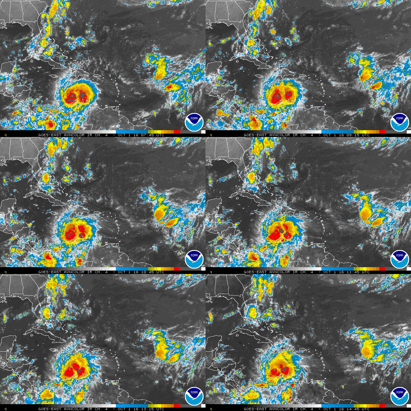
Area of Disturbed Weather Near Panama
Moderator: S2k Moderators
Forum rules
The posts in this forum are NOT official forecasts and should not be used as such. They are just the opinion of the poster and may or may not be backed by sound meteorological data. They are NOT endorsed by any professional institution or STORM2K. For official information, please refer to products from the National Hurricane Center and National Weather Service.
Re: area of disturbed weather near Panama
I wonder if it will go poof in the morning or slide into Central America
0 likes
-
TheStormExpert
At the very least you'd think the NHC could mention it and give it a 0/0% like they have done with a few areas so far this season. My guess is they have overestimated the percentages of many different areas this season (mostly TW's rolling off Africa) that they are afraid to jump on board to only have a repeat in some way or another.
0 likes
Re: area of disturbed weather near Panama
I can plainly see the concentration of cloudiness and convection in the SW Caribbean, but nothing is going to immediately come out of all of that given the present upper level shear. By my eye, one might make a case for an upper ridge over S. America appearing to be very slowly building northward but conditions just are not there yet. Besides, if we're even going to hang our hats on the GFS and GEM models for development, there not suggesting that is even going to occur until approx. 182 hours. I'm curious if tonight's GFS 0 Z run will maintain continuity and continue to eventually develop "something" in the Yucatan area.
0 likes
Andy D
(For official information, please refer to the NHC and NWS products.)
(For official information, please refer to the NHC and NWS products.)
- Hurricaneman
- Category 5

- Posts: 7404
- Age: 45
- Joined: Tue Aug 31, 2004 3:24 pm
- Location: central florida
Re: area of disturbed weather near Panama
One of the things going in favor of this is that there is strong convection at 13N 80W with even greys showing up on IR
0 likes
Re: area of disturbed weather near Panama
boca wrote:I wonder if it will go poof in the morning or slide into Central America
My thoughts exactly -
0 likes
Local Met mentioned that models try to spin up something in SW Carib. In the next week. Added that models have been doing that all season!
0 likes
Personal Forecast Disclaimer:
My posts are just my opinion and are most likely not backed by sound meteorological data. They are NOT endorsed by any professional institution or storm2k.org. For official information, please refer to the NHC and NWS products.
Bottom line is that I am just expressing my opinion!!!
My posts are just my opinion and are most likely not backed by sound meteorological data. They are NOT endorsed by any professional institution or storm2k.org. For official information, please refer to the NHC and NWS products.
Bottom line is that I am just expressing my opinion!!!
Re: area of disturbed weather near Panama
Huge blowup of convection in SW Caribbean overnight - let's see if it persists today.
http://www.ssd.noaa.gov/goes/east/watl/flash-avn.html
http://www.ssd.noaa.gov/goes/east/watl/flash-avn.html
0 likes
Re: area of disturbed weather near Panama
I've been watching that to RonJon. NOt so much worried about what the models says. They haven't been very good this year so I will trust my visual, synoptics and history.
Last edited by caneman on Tue Oct 07, 2014 8:54 am, edited 1 time in total.
0 likes
- cycloneye
- Admin

- Posts: 149275
- Age: 69
- Joined: Thu Oct 10, 2002 10:54 am
- Location: San Juan, Puerto Rico
Re: area of disturbed weather near Panama
No mention by NHC at 8 AM TWO. Off-topic=I think the peeps should go and follow a Typhoon that may come close to what Haiyan did in 2013. See it here
0 likes
Visit the Caribbean-Central America Weather Thread where you can find at first post web cams,radars
and observations from Caribbean basin members Click Here
and observations from Caribbean basin members Click Here
- Hurricaneman
- Category 5

- Posts: 7404
- Age: 45
- Joined: Tue Aug 31, 2004 3:24 pm
- Location: central florida
Re: area of disturbed weather near Panama
If you go by the model consensus this will probably be an EPAC system
0 likes
- tropicwatch
- Category 5

- Posts: 3426
- Age: 62
- Joined: Sat Jun 02, 2007 10:01 am
- Location: Panama City Florida
- Contact:
There still is a lot of shear in that area but what an impressive blowup of showers.


0 likes
Tropicwatch
Agnes 72', Eloise 75, Elena 85', Kate 85', Charley 86', Florence 88', Beryl 94', Dean 95', Erin 95', Opal 95', Earl 98', Georges 98', Ivan 2004', Arlene 2005', Dennis 2005', Ida 2009' Debby 2012' Irma 2017' Michael 2018'
Agnes 72', Eloise 75, Elena 85', Kate 85', Charley 86', Florence 88', Beryl 94', Dean 95', Erin 95', Opal 95', Earl 98', Georges 98', Ivan 2004', Arlene 2005', Dennis 2005', Ida 2009' Debby 2012' Irma 2017' Michael 2018'
Re: area of disturbed weather near Panama
Is it possible to get one system out of each. 1 in E.Pac and one in Carrib?
0 likes
Re: Area of Disturbed Weather Near Panama
Now I'm on board. It's hard to keep an entire season down.
0 likes
- gatorcane
- S2K Supporter

- Posts: 23708
- Age: 48
- Joined: Sun Mar 13, 2005 3:54 pm
- Location: Boca Raton, FL
Looping the SAT imagery, I am starting to see some cyclonic spin just north of Panama. I also see possible spin on the EPAC side too. Shear seems to have relaxed over the area. Models clearly struggling with this because of the two areas of possible development though the SW Carib area looks more robust at the moment.
Also note the energy over the GOM which is creating a trough that might be enough to pull the SW Carib area northwestward gradually:

Also note the energy over the GOM which is creating a trough that might be enough to pull the SW Carib area northwestward gradually:

Last edited by gatorcane on Tue Oct 07, 2014 11:57 am, edited 1 time in total.
0 likes
- alienstorm
- Category 1

- Posts: 496
- Joined: Tue Jul 31, 2007 1:29 pm
- Location: Miami Fla western suburb
Re: Area of Disturbed Weather Near Panama
That is correct and while this may be a long process we are starting to see some turning
http://rammb.cira.colostate.edu/ramsdis ... display=12
http://rammb.cira.colostate.edu/ramsdis ... display=12
0 likes
Personal Forecast Disclaimer:The posts in this forum are NOT official forecast and should not be used as such. They are just the opinion of the poster and may or may not be backed by sound meteorological data. They are NOT endorsed by any professional institution or storm2k.org. For official information, please refer to the NHC and NWS products.
Who is online
Users browsing this forum: No registered users and 193 guests


