Hurricane Patricia's remains in the Gulf
Moderator: S2k Moderators
Forum rules

The posts in this forum are NOT official forecasts and should not be used as such. They are just the opinion of the poster and may or may not be backed by sound meteorological data. They are NOT endorsed by any professional institution or STORM2K. For official information, please refer to products from the National Hurricane Center and National Weather Service.
-
Weatherwatcher98
- Category 1

- Posts: 346
- Joined: Sat Sep 12, 2015 10:53 am
Re: Hurricane Patricia's remains in the Gulf
Looks like a Bunch of much needed rain.  Too much shear.
0 likes
Personal Forecast Disclaimer:
The posts in this forum are NOT official forecast and should not be used as such. They are just the opinion of the poster and may or may not be backed by sound meteorological data. They are NOT endorsed by any professional institution or storm2k.org. For official information, please refer to the NHC and NWS products.
The posts in this forum are NOT official forecast and should not be used as such. They are just the opinion of the poster and may or may not be backed by sound meteorological data. They are NOT endorsed by any professional institution or storm2k.org. For official information, please refer to the NHC and NWS products.
-
tolakram
- Admin

- Posts: 20179
- Age: 62
- Joined: Sun Aug 27, 2006 8:23 pm
- Location: Florence, KY (name is Mark)
Re: Hurricane Patricia's remains in the Gulf
0 likes
M a r k
- - - - -
Join us in chat: Storm2K Chatroom Invite. Android and IOS apps also available.
The posts in this forum are NOT official forecasts and should not be used as such. Posts are NOT endorsed by any professional institution or STORM2K.org. For official information and forecasts, please refer to NHC and NWS products.

Re:
Steve wrote:NHC intitially went with nontropical as mid and upper remnants pulled ne and the lower level remnants will become absorbed into the low winding up in Texas. Like I said last night, I think there will be gale force conditions in the nw gulf and coastal areas, so tropical storm conditions should be present regardless of whether there is enough time over water or whether or not nhc classifies as tropical or subtropical. If they are right with the absorption and phase, and if the lower-level circulation gets 18-36 hours over the Gulf, I think we get an STS. That would be my call with 45mph winds with gusts to 60-65 offshore. Let's see what happens.
Disclaimer: This is not an official forecast. Go with the NHC
Edit: floater visible shows a hook blowing up closer to the coast than where the surface maps show a low. its probably the midlevel remnants. http://www.ssd.noaa.gov/PS/TROP/floater ... imated.gif
Based upon their products, unless this has an eye, it will NEVER be named. To be honest, I am not sure they will ever name a crossover
0 likes
-
Weatherwatcher98
- Category 1
- Posts: 346
- Joined: Sat Sep 12, 2015 10:53 am
Re: Hurricane Patricia's remains in the Gulf
000
WTPZ45 KNHC 242031
TCDEP5
POST-TROPICAL CYCLONE PATRICIA DISCUSSION NUMBER 20
NWS NATIONAL HURRICANE CENTER MIAMI FL EP202015
400 PM CDT SAT OCT 24 2015
Satellite imagery and surface observations from northern Mexico
indicate that Patricia has degenerated to a remnant low pressure
area characterized by no organized convection and a poorly defined
surface circulation. The remnant low is expected to move
northeastward and weaken to a trough during the next several hours,
with the trough being absorbed by a non-tropical area of low
pressure over southern Texas tonight or on Sun
0 likes
Personal Forecast Disclaimer:
The posts in this forum are NOT official forecast and should not be used as such. They are just the opinion of the poster and may or may not be backed by sound meteorological data. They are NOT endorsed by any professional institution or storm2k.org. For official information, please refer to the NHC and NWS products.
The posts in this forum are NOT official forecast and should not be used as such. They are just the opinion of the poster and may or may not be backed by sound meteorological data. They are NOT endorsed by any professional institution or storm2k.org. For official information, please refer to the NHC and NWS products.


Re: Re:
Alyono wrote:Steve wrote:NHC intitially went with nontropical as mid and upper remnants pulled ne and the lower level remnants will become absorbed into the low winding up in Texas. Like I said last night, I think there will be gale force conditions in the nw gulf and coastal areas, so tropical storm conditions should be present regardless of whether there is enough time over water or whether or not nhc classifies as tropical or subtropical. If they are right with the absorption and phase, and if the lower-level circulation gets 18-36 hours over the Gulf, I think we get an STS. That would be my call with 45mph winds with gusts to 60-65 offshore. Let's see what happens.
Disclaimer: This is not an official forecast. Go with the NHC
Edit: floater visible shows a hook blowing up closer to the coast than where the surface maps show a low. its probably the midlevel remnants. http://www.ssd.noaa.gov/PS/TROP/floater ... imated.gif
Based upon their products, unless this has an eye, it will NEVER be named. To be honest, I am not sure they will ever name a crossover
I hear you. I just think its gonna be an sst. 18z Nam high-res radar simulation actually closes off a tight inner circulation at landfall near Vermillion Parish/Abbeville. That's sort of inline with the 00z EC. I haven't looked at the 12 yet.
36 hr nam hires
http://mag.ncep.noaa.gov/Image.php?fhr= ... eSize=&ps=
And 42 hours
http://mag.ncep.noaa.gov/Image.php?fhr= ... eSize=&ps=
0 likes

Re: Hurricane Patricia's remains in the Gulf
I live just north of Galveston and the rain has been light all day until now.
0 likes
Alicia, Rita, Ike, Harvey and Beryl...moved to Splendora lol

Re: Re:
Steve wrote:Alyono wrote:Steve wrote:NHC intitially went with nontropical as mid and upper remnants pulled ne and the lower level remnants will become absorbed into the low winding up in Texas. Like I said last night, I think there will be gale force conditions in the nw gulf and coastal areas, so tropical storm conditions should be present regardless of whether there is enough time over water or whether or not nhc classifies as tropical or subtropical. If they are right with the absorption and phase, and if the lower-level circulation gets 18-36 hours over the Gulf, I think we get an STS. That would be my call with 45mph winds with gusts to 60-65 offshore. Let's see what happens.
Disclaimer: This is not an official forecast. Go with the NHC
Edit: floater visible shows a hook blowing up closer to the coast than where the surface maps show a low. its probably the midlevel remnants. http://www.ssd.noaa.gov/PS/TROP/floater ... imated.gif
Based upon their products, unless this has an eye, it will NEVER be named. To be honest, I am not sure they will ever name a crossover
I hear you. I just think its gonna be an sst. 18z Nam high-res radar simulation actually closes off a tight inner circulation at landfall near Vermillion Parish/Abbeville. That's sort of inline with the 00z EC. I haven't looked at the 12 yet.
36 hr nam hires
http://mag.ncep.noaa.gov/Image.php?fhr= ... eSize=&ps=
And 42 hours
http://mag.ncep.noaa.gov/Image.php?fhr= ... eSize=&ps=
I live here in Vermilion Parish - I'll let you know about conditions here.
0 likes
Audrey (1957), Carla (1961), Hilda (1964), Betsy (1965), Edith (1971), Carmen (1974), Danny (1985), Juan (1985), Andrew (1992), Lili (2002), Rita (2005), Gustav (2008), Ike (2008), and stuck in the eye of Iniki (1992) while vacationing in Kauai.
Not an official forecast by any means.
Not an official forecast by any means.
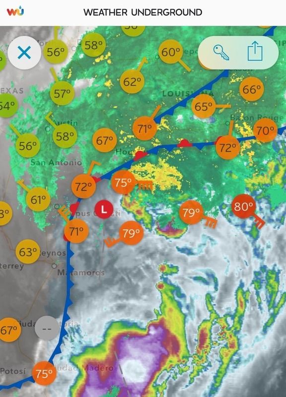
Should be pretty squally. There are a ton of flash flood warnings out in South Texas around Victoria, Corpus Christi and then up by Bay City. 12z ECMWF operational) at 48 hours has a pretty tight low in your area. http://moe.met.fsu.edu/cgi-bin/ecmwf-op ... hour=048hr
Here is the Ensembles. http://moe.met.fsu.edu/cgi-bin/ecmwf-en ... hour=048hr
Also I'm pretty sure the remnant surface low is catching up to that blowup just south of Brownsville. Might be some juice later on tonight as old surface low gets toward the coast. http://www.ssd.noaa.gov/PS/TROP/floater ... imated.gif
0 likes
-
CYCLONE MIKE
- Category 5

- Posts: 2183
- Joined: Tue Aug 31, 2004 6:04 pm
- Location: Gonzales, LA
Re: Hurricane Patricia's remains in the Gulf
If that verifys should get some pretty good squalls as we will be in the right front quadrant. Who would have thought, might be finally getting the much hyped homebrew of the season.
0 likes

Re: Hurricane Patricia's remains in the Gulf
Check out radar out of Brownsville
http://radar.weather.gov/ridge/radar.ph ... O&loop=yes
http://radar.weather.gov/ridge/radar.ph ... O&loop=yes
0 likes
The following post is NOT an official forecast and should not be used as such. It is just the opinion of the poster and may or may not be backed by sound meteorological data. It is NOT endorsed by any professional institution including storm2k.org For Official Information please refer to the NHC and NWS products.

Re: Hurricane Patricia's remains in the Gulf
0 likes

Re: Hurricane Patricia's remains in the Gulf
IR Enhancement 4

The area of thunderstorms has very cold cloud tops.
Here is a Doppler radar image out of Brownsville.

The area of thunderstorms has very cold cloud tops.
Here is a Doppler radar image out of Brownsville.
0 likes
Re: Hurricane Patricia's remains in the Gulf
CYCLONE MIKE wrote:If that verifys should get some pretty good squalls as we will be in the right front quadrant. Who would have thought, might be finally getting the much hyped homebrew of the season.
Stay safe Cyclone Mike - looks like we're in for a little rough and tumble. I'm in Vermilion Parish to your west.
0 likes
Audrey (1957), Carla (1961), Hilda (1964), Betsy (1965), Edith (1971), Carmen (1974), Danny (1985), Juan (1985), Andrew (1992), Lili (2002), Rita (2005), Gustav (2008), Ike (2008), and stuck in the eye of Iniki (1992) while vacationing in Kauai.
Not an official forecast by any means.
Not an official forecast by any means.
-
CourierPR

- Category 5
- Posts: 1336
- Age: 72
- Joined: Tue Aug 31, 2004 7:53 pm
- Location: Pompano Beach, Florida
Re: Hurricane Patricia's remains in the Gulf
To me, the system now looks more frontal but there could be some gales in the area.
0 likes
-
bamajammer4eva
- Category 4

- Posts: 907
- Joined: Sun Apr 18, 2010 3:21 am
- Location: Ozark, AL
Re: Hurricane Patricia's remains in the Gulf
May not be a Tropical Cyclone by definition but NAM seems to see a twist in the atmosphere nonetheless. Here is 06z NAM tornado parameters for Tues overnight-low end threat but a scattered possibility still if correct. We shall see if spc agrees as there is currently no risk for Tuesday.

0 likes
This morning the storm has the looks of a more extra tropical system than a subtropical storm but a strong one nonetheless, with many oil platforms reporting gale force wind gusts, this is very common during El Niño years to see these storms take advantage of the very warm gulf waters and aided by a strong subtropical jet stream.

0 likes
Some of the strongest winds reported from offshore rigs/stations earlier this morning.
Conditions at: KEMK (E BREAKS 165 , TX, US) observed 0635 UTC 25 October 2015
Temperature: 26.0°C (79°F)
Dewpoint: 25.0°C (77°F) [RH = 94%]
Pressure (altimeter): 29.67 inches Hg (1004.8 mb)
Winds: from the ESE (120 degrees) at 53 MPH (46 knots; 23.9 m/s)
gusting to 66 MPH (57 knots; 29.6 m/s)
Visibility: 0.25 miles (0.40 km)
Ceiling: 400 feet AGL
Clouds: broken clouds at 400 feet AGL
overcast cloud deck at 700 feet AGL
Weather: FG (fog)
0 likes
BTW, earlier today buoy 42019 reported a pressure of 996mb, rising now as the low pressure is moving away from it.
10 25 4:50 am S 27.2 33.0 12.8 8 6.7 SE 29.42
http://www.ndbc.noaa.gov/station_page.php?station=42019
10 25 4:50 am S 27.2 33.0 12.8 8 6.7 SE 29.42
http://www.ndbc.noaa.gov/station_page.php?station=42019
0 likes
Who is online
Users browsing this forum: No registered users and 189 guests