


Tropical wave east of the Windward Islands (Is Invest 98L)
Moderator: S2k Moderators
Forum rules

The posts in this forum are NOT official forecasts and should not be used as such. They are just the opinion of the poster and may or may not be backed by sound meteorological data. They are NOT endorsed by any professional institution or STORM2K. For official information, please refer to products from the National Hurricane Center and National Weather Service.
Re: Tropical Wave Near 42W
Latest EPS. May have been a good call to make this thread as early as you did Larry.
1 likes
-
SFLcane

- S2K Supporter

- Posts: 10281
- Age: 48
- Joined: Sat Jun 05, 2010 1:44 pm
- Location: Lake Worth Florida
Re: Tropical Wave Near 42W
The NW movement in the western Caribbean sure is an eye opener on the EPS. 
5 likes

Re: Tropical Wave Near 42W
SFLcane wrote:The NW movement in the western Caribbean sure is an eye opener on the EPS.
https://i.postimg.cc/905CsC5b/08-D4387-B-8-D2-D-442-E-A799-DF0-A57288-E40.gif
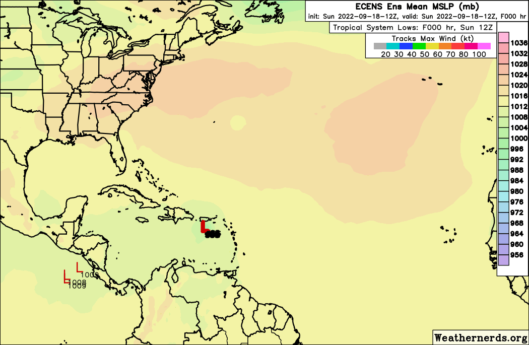
As we're now in the second half of September the WCar season has only really just started. 35 of the 58 (60%) MHs to pass through the WCar (if taken as the polygon below) didn't form until after today. Especially with the current high OHC due to a lack of activity in the region earlier this season, I fear the big show of this season might still be upcoming.

6 likes

Re: Tropical Wave Near 42W
LarryWx wrote:Iceresistance and myself have been following this since 48 hours ago, when it was producing plentiful convection in western Africa. There have been a good number of runs of various operational models as well as ensemble members taking this into the western basin as at least a weak surface low. About 9 hours ago, I posted in the TW thread that it appeared to me per satellite loops that there was a circulation at 11N, 23W, with impressive convection moving west.
This only waned a little after I last posted that. Now, check it out as we start to head toward DMAX, which is still 5-6 hours away in the E MDR. Convection has again blossomed in a circular pattern now centered on 11N, 24W. It looks even more impressive than it looked early today. This has the makings of a sleeper as the NHC doesn't mention this in the TWO.
By the way, I'm not sure if this is directly associated with AEW #40.

Great job guys picking this up.
The Uke has low pressure in the Caribbean as well as well as the Icon and JMA so this looks very legit.
Ukmet:

Icon:

JMA:

1 likes
The following post is NOT an official forecast and should not be used as such. It is just the opinion of the poster and may or may not be backed by sound meteorological data. It is NOT endorsed by any professional institution including storm2k.org For Official Information please refer to the NHC and NWS products.
-
Iceresistance

- Category 5

- Posts: 9606
- Age: 22
- Joined: Sat Oct 10, 2020 9:45 am
- Location: Tecumseh, OK/Norman, OK
Re: Tropical Wave Near 42W
It has produced some convection in the past 12 hours, but that is all it likely needs to survive going into the Caribbean.
2 likes
Bill 2015 & Beta 2020
Winter 2020-2021
All observations are in Tecumseh, OK unless otherwise noted.
Winter posts are focused mainly for Oklahoma & Texas.
Take any of my forecasts with a grain of salt, refer to the NWS, SPC, and NHC for official information
Never say Never with weather! Because ANYTHING is possible!
Winter 2020-2021
All observations are in Tecumseh, OK unless otherwise noted.
Winter posts are focused mainly for Oklahoma & Texas.
Take any of my forecasts with a grain of salt, refer to the NWS, SPC, and NHC for official information
Never say Never with weather! Because ANYTHING is possible!

Re: Tropical Wave Near 42W
The GFS sort of splits the energy with this wave. The eastern half gets tangled up in an upper-low that will be moving west alongside it over the next few days, while the western half skirts the coast of SA before heading off into the Caribbean.
1 likes
-
SFLcane
- S2K Supporter
- Posts: 10281
- Age: 48
- Joined: Sat Jun 05, 2010 1:44 pm
- Location: Lake Worth Florida
Re: Tropical Wave Near 43W
Not sure what to believe this year from the models to be quite honest. Even the eps has had its share of ghost storms. 18z gfs has 0 in the Caribbean.
0 likes
Re: Tropical Wave Near 43W
SFLcane wrote:The NW movement in the western Caribbean sure is an eye opener on the EPS.
https://i.postimg.cc/905CsC5b/08-D4387-B-8-D2-D-442-E-A799-DF0-A57288-E40.gif
There are a significant number (nearly 25%) of 12Z EPS members landfalling on the CONUS 9/29-10/2 as hurricanes or as a strong TS from TX through NC with also a couple of still offshore threats. At least half of these hit the FL Gulf coast, which is my #1 risk area this season based on third year cold ENSO analogs. Being that this was a more active EPS run than prior ones, I wouldn't be surprised if most of the next ones over the next few days aren't as active. Regardless, this will more than likely be the next potential threat period on the CONUS.
0 likes
Personal Forecast Disclaimer:
The posts in this forum are NOT official forecasts and should not be used as such. They are just the opinion of the poster and may or may not be backed by sound meteorological data. They are NOT endorsed by any professional institution or storm2k.org. For official information, please refer to the NHC and NWS products.
The posts in this forum are NOT official forecasts and should not be used as such. They are just the opinion of the poster and may or may not be backed by sound meteorological data. They are NOT endorsed by any professional institution or storm2k.org. For official information, please refer to the NHC and NWS products.
-
SFLcane
- S2K Supporter
- Posts: 10281
- Age: 48
- Joined: Sat Jun 05, 2010 1:44 pm
- Location: Lake Worth Florida
Re: Tropical Wave Near 43W
LarryWx wrote:SFLcane wrote:The NW movement in the western Caribbean sure is an eye opener on the EPS.
https://i.postimg.cc/905CsC5b/08-D4387-B-8-D2-D-442-E-A799-DF0-A57288-E40.gif
There are a significant number (nearly 25%) of 12Z EPS members landfalling on the CONUS 9/29-10/2 as hurricanes or as a strong TS from TX through NC with also a couple of still offshore threats. At least half of these hit the FL Gulf coast, which is my #1 risk area this season based on third year cold ENSO analogs. Being that this was a more active EPS run than prior ones, I wouldn't be surprised if most of the next ones over the next few days aren't as active. Regardless, this will more than likely be the next potential threat period on the CONUS.
I here ya Larry but how many times have we seen that this year with the Eps? Only to end up nothing but bluff. Just saying I am at the point of I will believe it when I see it.
1 likes

Re: Tropical Wave Near 43W
SFLcane wrote:LarryWx wrote:SFLcane wrote:The NW movement in the western Caribbean sure is an eye opener on the EPS.
https://i.postimg.cc/905CsC5b/08-D4387-B-8-D2-D-442-E-A799-DF0-A57288-E40.gif
There are a significant number (nearly 25%) of 12Z EPS members landfalling on the CONUS 9/29-10/2 as hurricanes or as a strong TS from TX through NC with also a couple of still offshore threats. At least half of these hit the FL Gulf coast, which is my #1 risk area this season based on third year cold ENSO analogs. Being that this was a more active EPS run than prior ones, I wouldn't be surprised if most of the next ones over the next few days aren't as active. Regardless, this will more than likely be the next potential threat period on the CONUS.
I here ya Larry but how many times have we seen that this year with the Eps? Only to end up nothing but bluff. Just saying I am at the point of I will believe it when I see it.
On the other hand, no models developed Fiona at all until 2 days before it formed, and now we have a hurricane devastating Puerto Rico.
5 likes
TC naming lists: retirements and intensity
Most aggressive Advisory #1's in North Atlantic (cr. kevin for starting the list)
Most aggressive Advisory #1's in North Atlantic (cr. kevin for starting the list)
-
SFLcane
- S2K Supporter
- Posts: 10281
- Age: 48
- Joined: Sat Jun 05, 2010 1:44 pm
- Location: Lake Worth Florida
Re: Tropical Wave Near 43W
Teban54 wrote:SFLcane wrote:LarryWx wrote:
There are a significant number (nearly 25%) of 12Z EPS members landfalling on the CONUS 9/29-10/2 as hurricanes or as a strong TS from TX through NC with also a couple of still offshore threats. At least half of these hit the FL Gulf coast, which is my #1 risk area this season based on third year cold ENSO analogs. Being that this was a more active EPS run than prior ones, I wouldn't be surprised if most of the next ones over the next few days aren't as active. Regardless, this will more than likely be the next potential threat period on the CONUS.
I here ya Larry but how many times have we seen that this year with the Eps? Only to end up nothing but bluff. Just saying I am at the point of I will believe it when I see it.
On the other hand, no models developed Fiona at all until 2 days before it formed, and now we have a hurricane devastating Puerto Rico.
About time they get something right.
0 likes

-
NotSparta

- Professional-Met

- Posts: 1677
- Age: 24
- Joined: Fri Aug 18, 2017 8:24 am
- Location: Naples, FL
- Contact:
Re: Tropical Wave Near 43W
SFLcane wrote:LarryWx wrote:SFLcane wrote:The NW movement in the western Caribbean sure is an eye opener on the EPS.
https://i.postimg.cc/905CsC5b/08-D4387-B-8-D2-D-442-E-A799-DF0-A57288-E40.gif
There are a significant number (nearly 25%) of 12Z EPS members landfalling on the CONUS 9/29-10/2 as hurricanes or as a strong TS from TX through NC with also a couple of still offshore threats. At least half of these hit the FL Gulf coast, which is my #1 risk area this season based on third year cold ENSO analogs. Being that this was a more active EPS run than prior ones, I wouldn't be surprised if most of the next ones over the next few days aren't as active. Regardless, this will more than likely be the next potential threat period on the CONUS.
I here ya Larry but how many times have we seen that this year with the Eps? Only to end up nothing but bluff. Just saying I am at the point of I will believe it when I see it.
Over Africa, sure. But that bias mostly goes away for waves offshore like this one way out at 40W
3 likes
This post was probably an opinion of mine, and in no way is official. Please refer to http://www.hurricanes.gov for official tropical analysis and advisories.
My website, with lots of tropical wx graphics, including satellite and recon: http://cyclonicwx.com
My website, with lots of tropical wx graphics, including satellite and recon: http://cyclonicwx.com
-
skyline385

- Category 5
- Posts: 2728
- Age: 35
- Joined: Wed Aug 26, 2020 11:15 pm
- Location: Houston TX

-
Spacecoast

- Category 2

- Posts: 773
- Joined: Thu Aug 31, 2017 2:03 pm
Re: Tropical wave near 43W
"On the other hand, no models developed Fiona at all until 2 days before it formed, and now we have a hurricane devastating Puerto Rico."
Fiona developed into a tropical depression east of the Leeward Islands on September 14, .....
8 days after this ECMF run:
However, that system behind it turned out to be be a ghost, along with other phantoms
Fiona developed into a tropical depression east of the Leeward Islands on September 14, .....
8 days after this ECMF run:
However, that system behind it turned out to be be a ghost, along with other phantoms
3 likes

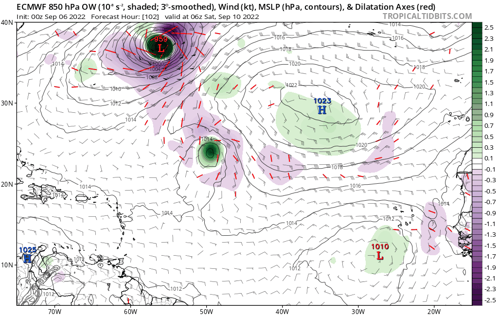
Re: Tropical wave near 43W
Spacecoast wrote:"On the other hand, no models developed Fiona at all until 2 days before it formed, and now we have a hurricane devastating Puerto Rico."
Fiona developed into a tropical depression east of the Leeward Islands on September 14, .....
8 days after this ECMF run:
https://i.postimg.cc/pX8GGTpL/A6-BD4-A6-B-9-DB6-4-D23-9-BBD-785-F0-AE789-A1.gif
However, that system behind it turned out to be be a ghost, along with other phantoms
The models developed Fiona way out in advance, dropped it for a while, then started to pick up on it as it began to form days later. This wave was also something the models developed and dropped…and now they’re picking up on it again. Feels very similar to the GFS and all the WCar storms in 2020, especially Zeta, which the model dropped for several days after showing its development 10+ days out.
2 likes
Irene '11 Sandy '12 Hermine '16 5/15/2018 Derecho Fay '20 Isaias '20 Elsa '21 Henri '21 Ida '21
I am only a meteorology enthusiast who knows a decent amount about tropical cyclones. Look to the professional mets, the NHC, or your local weather office for the best information.
I am only a meteorology enthusiast who knows a decent amount about tropical cyclones. Look to the professional mets, the NHC, or your local weather office for the best information.
-
skyline385
- Category 5
- Posts: 2728
- Age: 35
- Joined: Wed Aug 26, 2020 11:15 pm
- Location: Houston TX
Re: Tropical wave near 43W
Euro, CMC and ICON have been particularly trigger happy with every wave that lands in the MDR, something which is also seen in the Euro loop above in this thread. They show development for a while then start to back off as the conditions seem unfavorable. The same models had also turned back on development of Fiona and I personally don't think that them showing her development in a run more than a week ago along with a multitude of other systems which never happened should count as a positive for the model. In my opinion, this is the best example you can get of a broken clock being right twice.
1 likes
-
ElectricStorm

- Category 5
- Posts: 5154
- Age: 25
- Joined: Tue Aug 13, 2019 11:23 pm
- Location: Norman, OK
Re: Tropical wave near 43W
Considering how bad the models whiffed on Fiona at this range, this is definitely one to watch for down the road. Could be a dangerous track if it stays far enough south.
1 likes
B.S Meteorology, University of Oklahoma '25
Please refer to the NHC, NWS, or SPC for official information.
Please refer to the NHC, NWS, or SPC for official information.
Re: Tropical wave near 43W
Spacecoast wrote:"On the other hand, no models developed Fiona at all until 2 days before it formed, and now we have a hurricane devastating Puerto Rico."
Fiona developed into a tropical depression east of the Leeward Islands on September 14, .....
8 days after this ECMF run:
https://i.postimg.cc/pX8GGTpL/A6-BD4-A6-B-9-DB6-4-D23-9-BBD-785-F0-AE789-A1.gif
However, that system behind it turned out to be be a ghost, along with other phantoms
I was aware of this when making the initial comment. What I was describing, more accurately, was that all models dropped this wave just one or two days after the run you posted, which was also when pre-Fiona exited Africa. That was a typical sign of a Euro MDR phantom this season, so people started writing off any MDR development. Models continued to show no development until just before the wave actually developed.
Here's the TT thread for pre-96L/Fiona. Timeline:
- Splashdown on September 6, when many operational models and ensembles were still bullish on eventual development. The 12z 9/6 and 0z 9/7 operationals all showed at least a vortmax near the Lesser Antilles.
- Almost immediately after splashdown, models started dropping the wave one by one, starting 12z 9/7: GFS (12z 9/7), CMC (12z 9/7) , UKMET (0z 9/9, it consistently showed development before this). I can't find when the ECMWF and ICON dropped it, but at that time people called ICON too bullish.
- NHC dropped this wave at 8pm on 9/9. Euro briefly developed it the next day, only to quickly drop it.
- From 9/9 to 9/11, development was only shown on ensembles and less reliable models (UKMET, JMA and EPS), and even those were one or two runs only.
- NHC brought it back to TWO on 9/12. By then, the wave already showed clear signs of organization (in hindsight) and was convectively active.
- At 12z 9/12. it's like a switch flipped and many models started developing it. ICON 12z 9/12, UKMET 12z 9/12, GEFS 12z 9/12, Euro 18z 9/12, CMC 0z 9/13. Remember, this was only after the wave started firing convection and defying the belief of a hostile MDR.
- Invest 96L was declared on 9/13.
- GFS consistently showed no development during all of the above, until 6z 9/14. The wave developed into TD7 at 15z 9/14.
The fact that no reliable operational models showed any development from 9/9 to 9/11 is a big L to me. By the time they started to consistently develop the wave - 12z 9/12 - it was a mere 51 hours before development, and the wave was well on its way in organization. GFS didn't show development until 9 hours before it actually happened.
As for the modelcanes from 9/6 through 9/8, they are either one of the many MDR phantoms, or were at least portrayed as such at that time.
PS. I think this discussion should be moved to the Fiona model thread.
3 likes
TC naming lists: retirements and intensity
Most aggressive Advisory #1's in North Atlantic (cr. kevin for starting the list)
Most aggressive Advisory #1's in North Atlantic (cr. kevin for starting the list)
-
AJC3

- Admin

- Posts: 4156
- Age: 62
- Joined: Tue Aug 31, 2004 7:04 pm
- Location: Ballston Spa, New York
- Contact:
Re: Tropical wave near 43W
Teban54 wrote:Spacecoast wrote: <snip>
<snip>
PS. I think this discussion should be moved to the Fiona model thread.
Agreed that we should move on from this subthread. The tangetial points being made are starting to detract from the topic at hand.
2 likes
Who is online
Users browsing this forum: No registered users and 222 guests