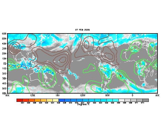
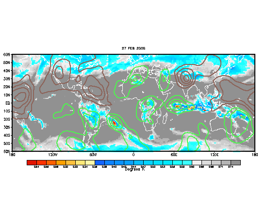
The MJO come July ....increased activity??

This is the general tropical discussion area. Anyone can take their shot at predicting a storms path.

Moderator: S2k Moderators

Forum rules

The posts in this forum are NOT official forecasts and should not be used as such. They are just the opinion of the poster and may or may not be backed by sound meteorological data. They are NOT endorsed by any professional institution or STORM2K. For official information, please refer to products from the National Hurricane Center and National Weather Service.

Help Support Storm2K
Message
Author
User avatar
cycloneye
Admin
Admin
Posts: 145888
Age: 69
Joined: Thu Oct 10, 2002 10:54 am
Location: San Juan, Puerto Rico

Re:

#21 Postby cycloneye » Thu Jun 28, 2007 7:40 pm

benny wrote:The MJO is a tricky beast in the Atlantic... works much better in the western and eastern Pacific. One question... where did you get that forecast map Aric Dunn? I have seen them before but can't remember where to find it again.

The models are showing some signs that the shear in the tropical Atlantic will reduce itself pretty significantly in a week or so. Check out:
http://www.cpc.ncep.noaa.gov/products/p ... hear_2.gif" target="_blank" target="_blank" target="_blank" target="_blank

I think the GF :froze: S is overdoing it.. but it shows a large are of low shear in the Atlantic. It takes more than shear this time of year... the stability is a big problem but that occasionally can be overcome. I think it will be more like mid July rather than early July cuz the GFS seems to move the MJO too fast (especially considering how slowly evolving the pattern is now).

I guess to summarize... I think we will have a chance at something in the low latitudes in July.. a la Dennis/Emily 05, Chantal 03, Bertha 96... (not necessarily very strong but something in July is pretty significant)... but it is hard to know. Maybe two weeks after the first WPAC storm forms roughly?


Benny,make it the third WPAC storm,not the first in 2007 and both that haved formed so far have been typhoons. :)

Image
0 likes   

User avatar
benny
Category 2
Category 2
Posts: 593
Joined: Sun Mar 19, 2006 8:09 am
Location: Miami

Re: The MJO come July ....increased activity??

#22 Postby benny » Thu Jun 28, 2007 7:47 pm

ah... first storm.. I meant of the Atlantic hurricane season (Jun 1)... for the western Pacific... that makes sense right? :) My atlantic-o central point of view... in any event, I meant the first one since 1 June... it is pretty rare I think for the WPAC to have nothing in June... someone had a list a while back but I can't recall who. I took a brief look at the best track and see that nothing formed in June of 1996 or 1998 (looking at June since 1995).
Last edited by benny on Thu Jun 28, 2007 7:53 pm, edited 1 time in total.
0 likes   

User avatar
cycloneye
Admin
Admin
Posts: 145888
Age: 69
Joined: Thu Oct 10, 2002 10:54 am
Location: San Juan, Puerto Rico

Re: The MJO come July ....increased activity??

#23 Postby cycloneye » Thu Jun 28, 2007 7:49 pm

benny wrote:ah... first storm.. I meant of the Atlantic hurricane season (Jun 1)... for the western Pacific... that makes sense right? :) My atlantic-o central point of view... in any event, I meant the first one since 1 June... it is pretty rare I think for the WPAC to have nothing in June... someone had a list a while back but I can't recall who.


Ok my friend,no problem. :)
0 likes   

User avatar
windstorm99
S2K Supporter
S2K Supporter
Posts: 1578
Age: 47
Joined: Sat May 26, 2007 8:10 am
Location: Miami, Florida
Contact:

Re: The MJO come July ....increased activity??

#24 Postby windstorm99 » Sun Jul 01, 2007 8:10 am

If the GFS is correct wind shear should decrease drastically in the next two weeks,and since the jet stream flow is forecast to be flattening out in two weeks,upper level winds should remain quite favorable for tropical cyclone development through the end of the month.Adrian

Here is a graphic on the MJO....Look at all the blue areas covering most areas in the atlantic starting from about the 10th to the end of month.

Blue means means upward motion which greatly needed for tropical cyclone development.

Image
0 likes   

User avatar
'CaneFreak
Category 5
Category 5
Posts: 1486
Joined: Mon Jun 05, 2006 10:50 am
Location: New Bern, NC

#25 Postby 'CaneFreak » Wed Jul 04, 2007 10:15 am

Hey Look!! The favorable MJO passed right by the Atlantic!! LOL It was here for a minute and then said, "C ya"!!!

http://www.cpc.ncep.noaa.gov/products/p ... thly.shtml

Do the loop and you will see what I am talking about...
0 likes   

TheRingo
Tropical Storm
Tropical Storm
Posts: 170
Joined: Sat Aug 26, 2006 4:46 pm

Re: The MJO come July ....increased activity??

#26 Postby TheRingo » Wed Jul 04, 2007 12:53 pm

This still shows the MJO phase is still in the Pacific and stalled there.

http://www.bom.gov.au/bmrc/clfor/cfstaf ... 90days.gif
0 likes   

User avatar
AnnularCane
S2K Supporter
S2K Supporter
Posts: 2872
Joined: Thu Jun 08, 2006 9:18 am
Location: Wytheville, VA

Re: The MJO come July ....increased activity??

#27 Postby AnnularCane » Wed Jul 04, 2007 1:31 pm

Wha...? I didn't know this thing stalled. I always assumed it kept moving.
0 likes   

TheRingo
Tropical Storm
Tropical Storm
Posts: 170
Joined: Sat Aug 26, 2006 4:46 pm

Re: The MJO come July ....increased activity??

#28 Postby TheRingo » Wed Jul 04, 2007 1:49 pm

AnnularCane wrote:Wha...? I didn't know this thing stalled. I always assumed it kept moving.


It looks like it's stalled there but maybe it's crossing over across the antarctic pole instead.
0 likes   

User avatar
benny
Category 2
Category 2
Posts: 593
Joined: Sun Mar 19, 2006 8:09 am
Location: Miami

MJO complicated right now

#29 Postby benny » Wed Jul 04, 2007 8:51 pm

It is very difficult to extract a MJO signal right now because there are many different types of tropical waves interacting. The bottom line is that globally.. most of the convection is still centered in the eastern hemisphere with the typical MJO response of enhanced upper highs due to convection over the western Pacific. Hence... the tropical cyclones that have been forming. Assuming a continued slow eastward propagation rate... the best upper conditions for genesis would be over the eastern Pacific in maybe 7-10 days or so.. then over the Atlantic a week or so after that. However... the MJO might not do much. It is just tough with SSTs only a little above average in the tropical Atlantic. Hard to know though.

Pretty long break without TCs in the eastern Pacific... had a similiar one last year though. it would be extremely rare to not having any storms form by 15 July...a break in formation of 50 days plus!
0 likes   

TheRingo
Tropical Storm
Tropical Storm
Posts: 170
Joined: Sat Aug 26, 2006 4:46 pm

#30 Postby TheRingo » Fri Jul 06, 2007 1:49 pm

see it didn't skip us. It's about to cross over.

Image
0 likes   

User avatar
MGC
S2K Supporter
S2K Supporter
Posts: 5903
Joined: Sun Mar 23, 2003 9:05 pm
Location: Pass Christian MS, or what is left.

Re: The MJO come July ....increased activity??

#31 Postby MGC » Sun Jul 08, 2007 4:25 pm

Per the CPC, the MJO is moving very slowly and the CPC expects the dry phase to remain in place across much of the Atlantic basin for the first half of July. This outlook appears to be verifying with all the dry air in the Atlantic. So, if anything does form it will likely be in the GOM, EC or WCarb IMO....MGC
0 likes   

User avatar
skysummit
S2K Supporter
S2K Supporter
Posts: 5305
Age: 49
Joined: Tue Aug 31, 2004 11:09 pm
Location: Ponchatoula, LA
Contact:

Re: The MJO come July ....increased activity??

#32 Postby skysummit » Sun Jul 08, 2007 8:05 pm

Well, if they say it's moving slowly and will be dry for much of the first half of July, does that mean it'll continue to move slowly when the wet phase is over us for the peak of the season? Hmmmm
0 likes   

User avatar
canetracker
S2K Supporter
S2K Supporter
Posts: 751
Age: 62
Joined: Wed Jul 27, 2005 8:49 pm
Location: Suburbia New Orleans...Harahan, LA

Re: The MJO come July ....increased activity??

#33 Postby canetracker » Tue Jul 10, 2007 8:32 pm

The MJO continues to progress nicely. Of course this latest available graphic is from 7/9 and I am sure it has progressed more since this graphic.
Image

Any thoughts on how this may effect our chances of development in the next few weeks?
0 likes   

User avatar
windstorm99
S2K Supporter
S2K Supporter
Posts: 1578
Age: 47
Joined: Sat May 26, 2007 8:10 am
Location: Miami, Florida
Contact:

Re: The MJO come July ....increased activity??

#34 Postby windstorm99 » Tue Jul 10, 2007 8:44 pm

canetracker wrote:The MJO continues to progress nicely. Of course this latest available graphic is from 7/9 and I am sure it has progressed more since this graphic.
Image

Any thoughts on how this may effect our chances of development in the next few weeks?


I think as we get the favorable part of the MJO now moving into the atlantic basin we should begin to see some activity in the next couple of weeks.Iam thinking from mid july to the begining of august.Adrian
0 likes   

User avatar
wxman57
Moderator-Pro Met
Moderator-Pro Met
Posts: 22991
Age: 67
Joined: Sat Jun 21, 2003 8:06 pm
Location: Houston, TX (southwest)

Re: The MJO come July ....increased activity??

#35 Postby wxman57 » Thu Jul 12, 2007 7:00 am

The MJO is just reaching the date line (180 deg) now. Latest projections bring it to the eastern Pacific toward the end of July. Studies have shown that there tends to be a significant increase in TC activity in the Gulf and Caribbean about 15 days after the MJO reaches the eastern Pacific. That points to the 2nd-3rd week of August. Here's the new graphic. Note no upward motion through July (left panel) for new forecast, old forecast is on right:

http://www.icess.ucsb.edu/asr/MJO_current_run.htm
0 likes   

LarryWx
S2K Supporter
S2K Supporter
Posts: 6401
Joined: Sun Sep 07, 2003 2:04 pm
Location: GA

Re: The MJO come July ....increased activity??

#36 Postby LarryWx » Thu Jul 12, 2007 7:47 am

It is my belief that these maps with greens and browns are overrated as far as their ability to determine peaks and lulls in the Atlantic season. I'm basing this strictly on my experience of following these charts for several years. During the heart of the active part of the season, I disinctly recall times when there was an active period when the browns dominated the Atlantic as well as inactive periods when there were greens. Whereas there may very well be some correlation, I really don't think there is a strong enough correlation to allow it to be a powerful predictor, especially when used alone.
0 likes   

User avatar
skysummit
S2K Supporter
S2K Supporter
Posts: 5305
Age: 49
Joined: Tue Aug 31, 2004 11:09 pm
Location: Ponchatoula, LA
Contact:

#37 Postby skysummit » Thu Jul 12, 2007 7:51 am

I don't believe anyone is using these MJO maps "alone". Simply enough, when we're in the wet phase, there's more convection. More convection = more of a chance of tropical development.
0 likes   

User avatar
canetracker
S2K Supporter
S2K Supporter
Posts: 751
Age: 62
Joined: Wed Jul 27, 2005 8:49 pm
Location: Suburbia New Orleans...Harahan, LA

Re: The MJO come July ....increased activity??

#38 Postby canetracker » Thu Jul 12, 2007 8:51 pm

Wxman57: Can you please explain to me why the Filtered OLR is the model you choose to use for the MJO? I have used all but found the Velocity Potential anomolies a bit easier to track. BTW, thanks for your posts as I always find them imformative.

Filtered OLR:
Image


Velocity Potential
Image

In regard to Larrywx:
It is my belief that these maps with greens and browns are overrated as far as their ability to determine peaks and lulls in the Atlantic season. I'm basing this strictly on my experience of following these charts for several years. During the heart of the active part of the season, I disinctly recall times when there was an active period when the browns dominated the Atlantic as well as inactive periods when there were greens. Whereas there may very well be some correlation, I really don't think there is a strong enough correlation to allow it to be a powerful predictor, especially when used alone.
I do agree with skysummit in that I don't believe anyone is using the MJO maps alone either. Most know their are many factors to consider, but if you have any reasoning to add to why your believe the velocity potential is over rated, I would like to hear your opinion as well.
0 likes   

User avatar
benny
Category 2
Category 2
Posts: 593
Joined: Sun Mar 19, 2006 8:09 am
Location: Miami

Re: The MJO come July ....increased activity??

#39 Postby benny » Thu Jul 12, 2007 9:00 pm

LarryWx wrote:It is my belief that these maps with greens and browns are overrated as far as their ability to determine peaks and lulls in the Atlantic season. I'm basing this strictly on my experience of following these charts for several years. During the heart of the active part of the season, I disinctly recall times when there was an active period when the browns dominated the Atlantic as well as inactive periods when there were greens. Whereas there may very well be some correlation, I really don't think there is a strong enough correlation to allow it to be a powerful predictor, especially when used alone.


I concur. It works much better in the eastern Pacific than the Atlantic. I think it is important earlier and later in the season when the Atlantic takes a bit of a large-scale kick to get things going.

The greens are misleading on the 11 July graphic. There is a Kelvin wave (faster moving MJO-like wave, having much of the same atmospheric response on a smaller scale) moving through the region which should temporarily enhance things. The best signal for the MJO is actually in the central pacific... but really it is hard to determine. Another Kelvin wave should move through the eastern Pacific in 5-7 days and enhance things... and maybe by that point things in the Atlantic might be more favorable to allow the Kelvin wave to work some magic in the 10 day timeframe. That's really tough to know as interacts with the tropical waves are critical and unforecastable at this lead time. The MJO is really slow... like 60 days period... look at :

http://www.bom.gov.au/bmrc/clfor/cfstaf ... 0days.html

It has taken 40 days to get most of the way around the globe... simple extrapolation puts it in the Atlantic in the last week of the month...
0 likes   

User avatar
cycloneye
Admin
Admin
Posts: 145888
Age: 69
Joined: Thu Oct 10, 2002 10:54 am
Location: San Juan, Puerto Rico

Re: The MJO come July ....increased activity??

#40 Postby cycloneye » Sat Jul 14, 2007 1:19 pm

I dont know if the development of the two Tropical Depressions and possibly named storms in the EPAC has to do with the wet phase of the MJO,but it's a coinsidence that the EPAC has been in the wet phase of MJO for more than 2 weeks and these two systems formed into TD'S.
0 likes   


Return to “Talkin' Tropics”

Who is online

Users browsing this forum: redingtonbeach and 39 guests