Weird cyclones - Impressive cyclones
Moderator: S2k Moderators
Forum rules

The posts in this forum are NOT official forecasts and should not be used as such. They are just the opinion of the poster and may or may not be backed by sound meteorological data. They are NOT endorsed by any professional institution or STORM2K. For official information, please refer to products from the National Hurricane Center and National Weather Service.

Re: Weird cyclones - Impressive cyclones
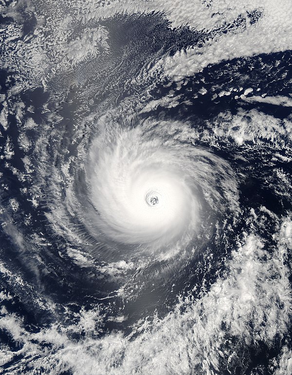
Looks like Monica had a central pressure of 880 to 905 mb. It almost looks like a perfect circle. The Dvorak looks at how circular a storm is.
0 likes
-
Honeyko
Re:
Please re-read my last sentence again. It applies only to the core of the storm. The rest of the circulation no doubt brought in a good soaking.vbhoutex wrote:Is that why Dolly or her remains flooded very arid areas of Texas and New Mexico when she didn't even have an ocean feed? IMO, your analysis doesn't hold water(pun intended).Honeyko wrote:The Tracy pic shows a well-fortified rainband to the northwest of the center, while the center itself looks shriveled up due to arid air entrainment. (It would eventually become a dust whorl while the out rainband continues so long as the ocean feed remains.)
The class is instructed to read "The Emperor's New Clothes" for another example of this fallacyCategory 5 wrote:Tracy is officially the smallest TC on record. Allow me to teach the class what that means. That means that NO recorded TC was EVER smaller.
When? Where? North coast? If so, irrelevant, because we're not talking about that. We're examining Monica in the GoC when she was a tinycane, not the next day after she exploded in coverage and had feeders running up to Indonesia.Chacor wrote:Tracy never had gale force winds farther than 30 statute miles from its centre, according to NOAA. Both the JTWC and BoM advisories on Monica had gale-force winds well over 100 nm from its centre.
(And yes; it's a lot easier to find those far-out winds with 2006 technology than with 1974 technology, which, if your memory serves, NOAA at the time had exactly what of in Darwin?)
0 likes
-
Category 5

- Category 5

- Posts: 10074
- Age: 35
- Joined: Sun Feb 11, 2007 10:00 pm
- Location: New Brunswick, NJ
- Contact:
Re: Re:
Honeyko wrote:(And yes; it's a lot easier to find those far-out winds with 2006 technology than with 1974 technology, which, if your memory serves, NOAA at the time had exactly what of in Darwin?)
Well then email Darwin with your proposal, then argue with them when they tell you you're wrong. We've tried over and over to teach you the facts and you continue to ignore them. It's like talking to a wall.
0 likes
-
HurricaneBill
- Category 5
- Posts: 3420
- Joined: Sun Apr 11, 2004 5:51 pm
- Location: East Longmeadow, MA, USA
Re: Weird cyclones - Impressive cyclones
I'm pretty sure the BoM in Darwin has studied Cyclone Tracy extensively and knows how big her windfield was.
0 likes
-
Ad Novoxium
- Category 1

- Posts: 348
- Age: 35
- Joined: Sat May 03, 2008 2:12 am
Re: Weird cyclones - Impressive cyclones
Not to be nebby, but this is quickly spiraling into uneasy territory. This topic is for weird and impressive cyclones, not whether Tracy maintains the record for smallest tropical cyclone. If you wish to continue, please create an alternate topic for it.
0 likes
-
Honeyko
Re: Weird cyclones - Impressive cyclones
Studied her extensively with what in 1974? QuikSCAT? Buoys? You're "pretty sure" why? "I'm pretty sure" sounds a lot like "I'm not certain, but would like to sell you on the premise that I am".HurricaneBill wrote:I'm pretty sure the BoM in Darwin has studied Cyclone Tracy extensively and knows how big her windfield was.
A lot of these "record" storms cling to their Oscar-winning titles due to lack of evidence, not due to it. E.g., nobody was out there sampling Tracy's wind radii, so an estimate is guessed....and carved it into granite and cited as gospel thirty-four years down the road. (We can toss Tip into that category too; there've been a number of storms that rational observers have reasoned have lower pressures, or theorize that Tip's wasn't as low as originally estimated.)
Tracy, to my eye, looks like a storm with sufficient wind radii to generate intense bands a good distance from the center, not a storm with 135mph (or up to 185, depending upon whom is referenced) all bunched within 30nm of the center. (Is that even synoptically possible? The gradient would have to be ridiculous. What would the central pressure have to be? Would it completely blow Tip out of the water?)
This one will do nicely for talking about Tracy, certainly a weird and impressive storm (and which you'll observe I have not disputed "maintains the record", but whether she actually merits it). Aside from that, what's making you uneasy? It's the Dull Days of August, and we're all having fun here, I hope. New pics are posted that many haven't seen, and all that.Ad Novoxium wrote:Not to be nebby, but this is quickly spiraling into uneasy territory. This topic is for weird and impressive cyclones, not whether Tracy maintains the record for smallest tropical cyclone. If you wish to continue, please create an alternate topic for it.
Now where's that "hurricane"-on-Mars photo? Google to the rescue....

0 likes

Re: Weird cyclones - Impressive cyclones
I'd like ton mention Daniel 2006 in EPAC, I think this is the first annular hurricane officially recognised as such by NOAA. With Daniel, nobody can argue it was not annular!
0 likes
-
Category 5
- Category 5
- Posts: 10074
- Age: 35
- Joined: Sun Feb 11, 2007 10:00 pm
- Location: New Brunswick, NJ
- Contact:
Re: Weird cyclones - Impressive cyclones
Honeyko wrote:Studied her extensively with what in 1974? QuikSCAT? Buoys? You're "pretty sure" why? "I'm pretty sure" sounds a lot like "I'm not certain, but would like to sell you on the premise that I am".HurricaneBill wrote:I'm pretty sure the BoM in Darwin has studied Cyclone Tracy extensively and knows how big her windfield was.
A lot of these "record" storms cling to their Oscar-winning titles due to lack of evidence, not due to it. E.g., nobody was out there sampling Tracy's wind radii, so an estimate is guessed....and carved it into granite and cited as gospel thirty-four years down the road. (We can toss Tip into that category too; there've been a number of storms that rational observers have reasoned have lower pressures, or theorize that Tip's wasn't as low as originally estimated.)
Tracy, to my eye, looks like a storm with sufficient wind radii to generate intense bands a good distance from the center, not a storm with 135mph (or up to 185, depending upon whom is referenced) all bunched within 30nm of the center. (Is that even synoptically possible? The gradient would have to be ridiculous. What would the central pressure have to be? Would it completely blow Tip out of the water?)This one will do nicely for talking about Tracy, certainly a weird and impressive storm (and which you'll observe I have not disputed "maintains the record", but whether she actually merits it). Aside from that, what's making you uneasy? It's the Dull Days of August, and we're all having fun here, I hope. New pics are posted that many haven't seen, and all that.Ad Novoxium wrote:Not to be nebby, but this is quickly spiraling into uneasy territory. This topic is for weird and impressive cyclones, not whether Tracy maintains the record for smallest tropical cyclone. If you wish to continue, please create an alternate topic for it.
I think assessing the damage is good enough evidence. Like I said, email Darwin with this proposal, and somebody with a met degree who has studied the storm will tell you you're wrong.
0 likes

Re: Weird cyclones - Impressive cyclones
Honeyko, I would advise you to stop this before you lose any OUNCE of credibility you have left on this board. Your assertion that Cyclone Monica is smaller than Tracy is wrong because: 1) Tracy's windfield was determined by surface observations at Darwin, and 2) Monica's windfield was well sampled as well. Despite it being 1974, anemometers did exist and were used to determine Tracy's small gradient. The reason we know so much about storms from the past are due to surface wind measurements....we know Camille was a modest sized hurricane hurricane winds about 40-60 miles east of the center because hurricane winds were not only measured by recon, but confirmed by surface reports. We know Carla was such a large hurricane because of the large amount of wind reports on the Texas coast. We know Tip is the lowest pressure recorded because a plane was INSIDE Tip and measured that pressure (I have no clue why you even questioned that). We know Wilma has the lowest pressure in the Atlantic Basin because of a plane recording this data. You can't argue with sound data, and honestly your attempts to try and prove your point are making you look foolish. That is all I will say on this, and mods feel free to edit/delete this if the wording was too strong.
0 likes
-
cheezyWXguy

- Category 5
- Posts: 6242
- Joined: Mon Feb 13, 2006 12:29 am
- Location: Dallas, TX
Re: Weird cyclones - Impressive cyclones
Honeyko wrote:Tracy, to my eye, looks like a storm with sufficient wind radii to generate intense bands a good distance from the center, not a storm with 135mph (or up to 185, depending upon whom is referenced) all bunched within 30nm of the center. (Is that even synoptically possible?
Yeah its totally possible...wilma did it...at its peak, hurricane winds only extended 15 miles from the center.
BTW...can you like, just leave or something? It gets really annoying when you post false information and then try to either back it up with false claims or dont back it up at all.
0 likes
-
Category 5
- Category 5
- Posts: 10074
- Age: 35
- Joined: Sun Feb 11, 2007 10:00 pm
- Location: New Brunswick, NJ
- Contact:
Re: Weird cyclones - Impressive cyclones
Normandy wrote:Honeyko, I would advise you to stop this before you lose any OUNCE of credibility you have left on this board. Your assertion that Cyclone Monica is smaller than Tracy is wrong because: 1) Tracy's windfield was determined by surface observations at Darwin, and 2) Monica's windfield was well sampled as well. Despite it being 1974, anemometers did exist and were used to determine Tracy's small gradient. The reason we know so much about storms from the past are due to surface wind measurements....we know Camille was a modest sized hurricane hurricane winds about 40-60 miles east of the center because hurricane winds were not only measured by recon, but confirmed by surface reports. We know Carla was such a large hurricane because of the large amount of wind reports on the Texas coast. We know Tip is the lowest pressure recorded because a plane was INSIDE Tip and measured that pressure (I have no clue why you even questioned that). We know Wilma has the lowest pressure in the Atlantic Basin because of a plane recording this data. You can't argue with sound data, and honestly your attempts to try and prove your point are making you look foolish. That is all I will say on this, and mods feel free to edit/delete this if the wording was too strong.
Yes I completely agree.
0 likes
-
P.K.

- Professional-Met

- Posts: 5149
- Joined: Thu Sep 23, 2004 5:57 pm
- Location: Watford, England
- Contact:
Re: Weird cyclones - Impressive cyclones
Tracy was tiny. To quote the BoM:
http://www.bom.gov.au/climate/environ/cyclone_tracy.shtml
Monica was a lot larger than this. Unfortunately the BT still isn't out which would round it all up nicely on here.
By world standards, Tracy was a small but intense tropical cyclone at landfall, the radius of gale force winds being only about 50 km. The central pressure of 950 hPa was close to the average for such systems, but the winds were unusually strong. The anemometer at Darwin Airport recorded a gust of 217 km/h before the instrument was destroyed.
http://www.bom.gov.au/climate/environ/cyclone_tracy.shtml
Monica was a lot larger than this. Unfortunately the BT still isn't out which would round it all up nicely on here.
0 likes
-
P.K.
- Professional-Met
- Posts: 5149
- Joined: Thu Sep 23, 2004 5:57 pm
- Location: Watford, England
- Contact:
Re: Weird cyclones - Impressive cyclones
Honeyko wrote:A lot of these "record" storms cling to their Oscar-winning titles due to lack of evidence, not due to it. E.g., nobody was out there sampling Tracy's wind radii, so an estimate is guessed....and carved it into granite and cited as gospel thirty-four years down the road. (We can toss Tip into that category too; there've been a number of storms that rational observers have reasoned have lower pressures, or theorize that Tip's wasn't as low as originally estimated.)
As a rough estimate I put some data together in a spreadsheet based on best track data etc I could find from all the RSMCs/TCWCs. Now the 30 year mean for the N Atlantic is around 11 named storms and the global mean is around 85.
Now not all N Atlantic TCs get reconnaissance flights and few outside this basin get any. Yes there are a few in the NE Pacific and the odd one in the CN Pacific but it doesn't account for a very high percentage of global TCs. Is this to say that the best track data for these other systems is worthless? Of course this isn't the case as the vast majority of TC advisories are based on Dvorak estimates etc so are all done the same way.
0 likes
-
Honeyko
Re: Weird cyclones - Impressive cyclones
Where? For the eighty-five billionth time, I'm not comparing Tracy to Monica while she was along the north coast, but when she was in the GoC. Honestly, would it kill you to read before you dogpile?Monica was a lot larger than this.

Because there are disputes as to whether or not extrapolations from flight-level to the surface was over-estimated in that era. Such disputes are nothing out of the ordinary (i.e., Andrew. etc).Normandy wrote:We know Tip is the lowest pressure recorded because a plane was INSIDE Tip and measured that pressure (I have no clue why you even questioned that).
0 likes
-
P.K.
- Professional-Met
- Posts: 5149
- Joined: Thu Sep 23, 2004 5:57 pm
- Location: Watford, England
- Contact:
Re: Weird cyclones - Impressive cyclones
I'm not comparing Tracy to Monica while she was along the north coast, but when she was in the GoC.
Ok well I've looked up some old advisories. This is from the centre of the GoC. Gale force winds from 80NM to 120NM from the centre (148km to 222km).
HIGH SEAS WEATHER WARNING
HIGH SEAS WEATHER WARNING FOR METAREA 10/11
Issued by the AUSTRALIAN BUREAU OF METEOROLOGY, DARWIN
Issued at 1330 UTC 22 APRIL 2006
PLEASE BE AWARE
Wind gusts can be a further 40 percent stronger than the averages given here,
and maximum waves may be up to twice the height.
HURRICANE WARNING FOR NORTHERN AREA
SITUATION
At 1200 UTC Severe Tropical Cyclone Monica estimated within 20 nautical miles of
12.1 S 138.7 E moving northwest at 5 knots. Central pressure 925 hPa.
AREA AFFECTED
Within 80 nautical miles of the centre, extending to 120 nautical miles in the
southern semicircle
FORECAST
Sustained winds to 125 knots near centre.
Winds above 64 knots within 20 nautical miles of centre with very high to
phenomenal seas.
Winds above 48 knots within 50 nautical miles of centre with very rough to high
seas and moderate to heavy swell.
Winds above 34 knots within 80 nautical miles of centre, extending to 120
nautical miles in the southern semicircle, with rough to very rough seas and
moderate swell.
0000 UTC 23 Apr: centre within 45 nautical miles of 11.7 S 137.6 E.
925 hPa. Winds to 125 knots near centre.
1200 UTC 23 Apr: centre within 80 nautical miles of 11.5 S 136.1 E.
925 hPa. Winds to 125 knots near centre.
REMARKS
Ships in the general area please transmit 3-hourly weather reports.
DARWIN Tropical Cyclone Warning Centre
This is the preceding advisory. Again gale force winds out to 90NM to 100NM. (167 - 185km)
HIGH SEAS WEATHER WARNING FOR METAREA 10/11
Issued by the AUSTRALIAN BUREAU OF METEOROLOGY, DARWIN
Issued at 0700 UTC 22 APRIL 2006
PLEASE BE AWARE
Wind gusts can be a further 40 percent stronger than the averages given here,
and maximum waves may be up to twice the height.
CORRECTED HURRICANE WARNING FOR NORTHERN AREA
SITUATION
At 0600 UTC Severe Tropical Cyclone Monica estimated within 20 nautical miles of
12.4 S 139.2 E moving slowly northwest. Central pressure 935 hPa.
AREA AFFECTED
Within 80 nautical miles of the centre, extending to 120 nautical miles in the
southern semicircle
FORECAST
Sustained winds to 110 knots near centre.
Winds above 64 knots within 20 nautical miles of centre with very high to
phenomenal seas.
Winds above 48 knots within 50 nautical miles of centre with very rough to high
seas and moderate to heavy swell.
Winds above 34 knots within 90 nautical miles of centre, extending to 100
nautical miles in the southern semicircle, with rough to very rough seas and
moderate swell.
1800 UTC 22 Apr: centre within 45 nautical miles of 11.9 S 138.4 E.
935 hPa. Winds to 110 knots near centre.
0600 UTC 23 Apr: centre within 80 nautical miles of 11.7 S 137.1 E.
935 hPa. Winds to 110 knots near centre.
REMARKS
Ships in the general area please transmit 3-hourly weather reports.
DARWIN Tropical Cyclone Warning Centre
0 likes
-
vbhoutex

- Storm2k Executive

- Posts: 29139
- Age: 74
- Joined: Wed Oct 09, 2002 11:31 pm
- Location: Cypress, TX
- Contact:
Re: Weird cyclones - Impressive cyclones
As was requested above, take the discussion concerning Tip, Tracy and Monica to another thread. They are not the only strange or different cyclones by a long shot. Please no more discussion concerning those sytems in this thread. Enough is enough!!! NO ONE IS GOING TO WIN AN ARGUMENT CONCERNING THIS SO LET IT GO!!!!
0 likes
-
Ad Novoxium
- Category 1
- Posts: 348
- Age: 35
- Joined: Sat May 03, 2008 2:12 am
Re: Weird cyclones - Impressive cyclones
For some reason, I loved Hurricane Frances of 1992's shape. Just one giant rainband.

0 likes

Who is online
Users browsing this forum: No registered users and 83 guests