Gulf of Mexico Disturbance--PGI37L
Moderator: S2k Moderators
Forum rules

The posts in this forum are NOT official forecasts and should not be used as such. They are just the opinion of the poster and may or may not be backed by sound meteorological data. They are NOT endorsed by any professional institution or STORM2K. For official information, please refer to products from the National Hurricane Center and National Weather Service.
-
South Texas Storms

- Professional-Met

- Posts: 4259
- Joined: Thu Jun 24, 2010 12:28 am
- Location: Houston, TX
Re: Gulf of Mexico Disturbance--PGI89T--Code Yellow
yeah i dont know which one of those models to believe right now. gfs has been struggling lately along with the nam in the tropics. which one are you going with right now? i say the euro...
0 likes
-
Wx_Warrior
- Category 5

- Posts: 2718
- Joined: Thu Aug 03, 2006 3:58 pm
- Location: Beaumont, TX
Re: Gulf of Mexico Disturbance--PGI89T--Code Yellow
I'm a EURO hugger, that's for sure. I believe a heavy, heavy rain maker with some moderate winds for Tejas. Should know clearly (HOPE) on Wed.
0 likes
-
South Texas Storms
- Professional-Met
- Posts: 4259
- Joined: Thu Jun 24, 2010 12:28 am
- Location: Houston, TX
Re: Gulf of Mexico Disturbance--PGI89T--Code Yellow
yeah im starting to become one this summer. i agree this will give texas a good soaking. its just a matter of the wind speeds. will it move onshore as a tropical storm or just as a tropical wave? hopefully we will know this by tommorow.
0 likes
-
HouTXmetro

- Category 5
- Posts: 3949
- Joined: Sun Jun 13, 2004 6:00 pm
- Location: District of Columbia, USA
-
srainhoutx

- S2K Supporter

- Posts: 6919
- Age: 68
- Joined: Sun Jan 14, 2007 11:34 am
- Location: Haywood County, NC
- Contact:
Re: Gulf of Mexico Disturbance--PGI89T--Code Yellow
Yep. A 1009mb low is anaylized on surface charts the morning E of Brownsville. Morning AFD from Corpus Christi, Houston and Lake Charles...
CRP:
THERE IS STILL CONSIDERABLE UNCERTAINTY WITH REGARDS TO THE WEEKEND
FORECAST AS 12Z AND 00Z MODELS HAVE BEEN FLIPPING BACK AND FORTH
BETWEEN WET/DRY SOLUTIONS. AND MUCH OF THIS UNCERTAINTY STEMS ON
WHETHER A WEAK TROPICAL CYCLONE DEVELOPS ALONG THE BOUNDARY IN THE
NW GULF. THE LATEST 00Z GFS/CANADIAN/UKMET/ECMWF NOW KEEP THE
SYSTEM AS AN OPEN WAVE AND MOVE THIS WEAK FEATURE INTO DEEP SOUTH
TEXAS ON SATURDAY WHICH SUPPORTS A WET FORECAST. THE 12Z ECMWF/00Z
NAM DEVELOP A T.D. AND MOVE IT NWD TOWARD THE PALACIOUS AREA WITH
MOST OF THE PRECIP FALLING OVER SOUTHEAST TEXAS KEEPING THE MID
COAST MOSTLY DRY. FOR THIS PACKAGE WILL MAINTAIN CONSISTENCY WITH
THE PREVIOUS FORECAST AND INDICATE CHC POPS THROUGH THE WEEKEND. IF
AN THE OPEN WAVE SOLUTION PANS OUT IT WILL BE A WET WEEKEND WITH HVY
RAIN PSBL. BUT IF A LOW DVLPS AND TRACKS TOWARD THE UPPER COAST WE
WILL BE MOSTLY DRY. EXPECT CHC OF RAIN TO CONTINUE THROUGH EARLY
NEXT WEEK AS A WEAK RIDGE PERSISTS ALOFT AND PWS REMAIN ABOVE 2
INCHES.
HGX:
AS THE SURFACE HIGH PRESSURE CENTER SHIFTS TO
NORTHEAST OF OUR REGION...THE TROUGH OF LOW PRESSURE OVER THE GULF
WILL APPROACH THE TEXAS COASTAL AND OFFSHORE WATERS LATE THIS WEEK
AND PUSH INLAND SATURDAY BRINGING A DEEP MOIST LAYER OVER OUR
REGION ESPECIALLY OVER THE SOUTHERN PORTIONS. GRADIENT WILL
TIGHTEN WITH SOUTHEAST FLOW. SPEED CONVERGENCE NEAR COASTAL REGION
WILL RESULT IN INCREASED RAIN CHANCES LATE FRIDAY NIGHT THROUGH THE
WEEKEND. PW VALUES WILL REMAIN RELATIVELY HIGH THIS COMING WEEKEND
THROUGH EARLY NEXT WEEK. WITH INCREASED CLOUD COVER...DAYTIME
TEMPERATURES THIS WEEKEND WILL BE BE SLIGHTLY LOWER FROM THE UPPER
80S NEAR THE COAST TO THE MID 90S FAR NORTHERN SECTIONS.
LCH:
INVERTED TROF OVER THE WESTERN GULF MIGRATES WEST AND NORTHWEST
WITH ACCOMPANYING ONSHORE FLOW DEVELOPING BRINGING RAIN CHANCES OVER
THE ENTIRE COASTAL WATERS FRIDAY AND NORTH TO NEAR THE I-10
CORRIDOR. RAIN CHANCES INCREASE FOR THE WEEKEND AND WILL
OVERSPREAD THE ENTIRE AREA AS THIS FEATURE MOVES INLAND. WILL
TREND POPS TO LOWER AND MORE SEASONAL LEVELS GOING INTO THE WORKWEEK.
0 likes
Carla/Alicia/Jerry(In The Eye)/Michelle/Charley/Ivan/Dennis/Katrina/Rita/Wilma/Ike/Harvey
Member: National Weather Association
Wx Infinity Forums
http://wxinfinity.com/index.php
Facebook.com/WeatherInfinity
Twitter @WeatherInfinity
Member: National Weather Association
Wx Infinity Forums
http://wxinfinity.com/index.php
Facebook.com/WeatherInfinity
Twitter @WeatherInfinity

-
Bailey1777
- S2K Supporter
- Posts: 962
- Joined: Mon Jul 31, 2006 6:23 pm
- Location: Houston, Texas
Re: Gulf of Mexico Disturbance--PGI89T--Code Yellow
kfdm can you give us your opinion on what may transpire and when? thanks.
0 likes
-
southerngale

- Retired Staff

- Posts: 27418
- Joined: Thu Oct 10, 2002 1:27 am
- Location: Southeast Texas (Beaumont area)
Re:
Agua wrote:If you folks in Tex are needing rain, I sure hope you get it. We absolutely don't need anymore over here. Can't keep the grass from tossling cutting it every week even.
According to the Drought Monitor, not many people in Texas really need rain. Looks like parts of Louisiana could use it, though. I've been getting storms, often with very heavy rain, just about every day it seems. It doesn't have to rain all day when you can pick up an inch or more in some of these cells (sometimes less).
0 likes
Please support Storm2k by making a donation today. It is greatly appreciated! Click here: 
 my Cowboys my Rockets my Astros
my Cowboys my Rockets my Astros-
redfish1
- Tropical Storm

- Posts: 125
- Age: 45
- Joined: Thu Jun 17, 2010 9:24 pm
- Location: Port Arthur, Tx
Re: Gulf of Mexico Disturbance--PGI89T--Code Yellow
does anyone think we could see an invest out of this today?
0 likes
-
ColinDelia

- S2K Supporter
- Posts: 918
- Joined: Mon Aug 29, 2005 5:52 am
- Location: The Beach, FL
Re: Gulf of Mexico Disturbance--PGI89T--Code Yellow
redfish1 wrote:does anyone think we could see an invest out of this today?
Not gonna venture a guess but PREDICT is following it now.
http://cimss.ssec.wisc.edu/tropic2/predict/#
(graphics will be up soon I'm sure)
0 likes

Re: Gulf of Mexico Disturbance--PGI89T--Code Yellow
southerngale wrote:Agua wrote:If you folks in Tex are needing rain, I sure hope you get it. We absolutely don't need anymore over here. Can't keep the grass from tossling cutting it every week even.
According to the Drought Monitor, not many people in Texas really need rain. Looks like parts of Louisiana could use it, though. I've been getting storms, often with very heavy rain, just about every day it seems. It doesn't have to rain all day when you can pick up an inch or more in some of these cells (sometimes less).
What's nuts is that the drought monitor shows my are to be in almost moderate drought conditions but I can gurantee you if you saw the runoff resevoirs you would say we've had enough. I know it's a cumulative total but in the last several weeks/months we've had out share of rain. Northern Louisiana sure could use some though.
0 likes


-
Portastorm

- Storm2k Moderator

- Posts: 9955
- Age: 63
- Joined: Fri Jul 11, 2003 9:16 am
- Location: Round Rock, TX
- Contact:
Re: Re:
southerngale wrote:Agua wrote:If you folks in Tex are needing rain, I sure hope you get it. We absolutely don't need anymore over here. Can't keep the grass from tossling cutting it every week even.
According to the Drought Monitor, not many people in Texas really need rain. Looks like parts of Louisiana could use it, though. I've been getting storms, often with very heavy rain, just about every day it seems. It doesn't have to rain all day when you can pick up an inch or more in some of these cells (sometimes less).
Drought schmout, SG! All I know is my lawn is brown and my water bill for August is going to be ugly. Give me rain!!
0 likes

Re: Gulf of Mexico Disturbance--PGI89T--Code Yellow
Also has an anti-cyclone forming overhead.
0 likes
-
srainhoutx
- S2K Supporter
- Posts: 6919
- Age: 68
- Joined: Sun Jan 14, 2007 11:34 am
- Location: Haywood County, NC
- Contact:
Re: Gulf of Mexico Disturbance--PGI89T--Code Yellow
Mine too Port! One brief shower in a month does not help. Hopefully the Upper Ridge will be broken at least.
0 likes
Carla/Alicia/Jerry(In The Eye)/Michelle/Charley/Ivan/Dennis/Katrina/Rita/Wilma/Ike/Harvey
Member: National Weather Association
Wx Infinity Forums
http://wxinfinity.com/index.php
Facebook.com/WeatherInfinity
Twitter @WeatherInfinity
Member: National Weather Association
Wx Infinity Forums
http://wxinfinity.com/index.php
Facebook.com/WeatherInfinity
Twitter @WeatherInfinity
-
southerngale
- Retired Staff
- Posts: 27418
- Joined: Thu Oct 10, 2002 1:27 am
- Location: Southeast Texas (Beaumont area)
SoupBone and Portastorm.... I hear ya. I know it's not always accurate. It has shown me in a drought when I had gotten plenty of rain, and vice versa. I guess it just shows drought / no drought for the majority of a specific area? We all know someone can get several inches of rain while someone else a few miles away doesn't get squat. Anyway, I don't need rain as I have been in the path of many storms/showers lately, but don't need to build an ark either.
0 likes
Please support Storm2k by making a donation today. It is greatly appreciated! Click here:
my Cowboys my Rockets my Astros
my Cowboys my Rockets my Astros-
southerngale
- Retired Staff
- Posts: 27418
- Joined: Thu Oct 10, 2002 1:27 am
- Location: Southeast Texas (Beaumont area)
Re: Gulf of Mexico Disturbance--PGI89T--Code Yellow
JB tweet about 4 hours ago:
Should have 6 named systems by Sep 1, 8 or 9 by the 10th. Western gulf residents should watch for "home brew" next 3 days
Should have 6 named systems by Sep 1, 8 or 9 by the 10th. Western gulf residents should watch for "home brew" next 3 days
0 likes
Please support Storm2k by making a donation today. It is greatly appreciated! Click here:
my Cowboys my Rockets my Astros
my Cowboys my Rockets my Astros-
ColinDelia
- S2K Supporter
- Posts: 918
- Joined: Mon Aug 29, 2005 5:52 am
- Location: The Beach, FL
Re: Gulf of Mexico Disturbance--PGI89T--Code Yellow
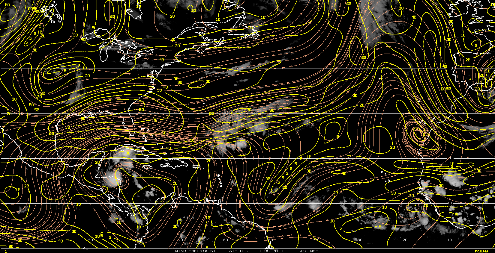
Orange = vorticity
Yellow = divergence
Cyan = convergence

Yellow = divergence
Cyan = convergence
0 likes
-
ColinDelia
- S2K Supporter
- Posts: 918
- Joined: Mon Aug 29, 2005 5:52 am
- Location: The Beach, FL
Who is online
Users browsing this forum: No registered users and 201 guests