
Nothing imminent that's for sure. Heaviest convection SE of JAM this morning - probably caused by UL divergence from the shear screaming across the northern caribbean. If this convection holds together and migrates toward the western caribbean then this might be the formation of the more eastern low pressure some models are hinting at. Based on this mornings Euro, I don't see anything developing anytime soon in the BOC - which is largely devoid of convection with high shear forecast through the next 72 hrs.
http://www.ssd.noaa.gov/goes/east/watl/flash-avn.html
NW Carribean / Southern GOM / BOC (Is invest 96L)
Moderator: S2k Moderators
Forum rules

The posts in this forum are NOT official forecasts and should not be used as such. They are just the opinion of the poster and may or may not be backed by sound meteorological data. They are NOT endorsed by any professional institution or STORM2K. For official information, please refer to products from the National Hurricane Center and National Weather Service.
-
Aric Dunn
- Category 5

- Posts: 21238
- Age: 43
- Joined: Sun Sep 19, 2004 9:58 pm
- Location: Ready for the Chase.
- Contact:
Re: NW Carribean / Southern GOM / BOC
ronjon wrote:Nothing imminent that's for sure. Heaviest convection SE of JAM this morning - probably caused by UL divergence from the shear screaming across the northern caribbean. If this convection holds together and migrates toward the western caribbean then this might be the formation of the more eastern low pressure some models are hinting at. Based on this mornings Euro, I don't see anything developing anytime soon in the BOC - which is largely devoid of convection with high shear forecast through the next 72 hrs.
http://www.ssd.noaa.gov/goes/east/watl/flash-avn.html
expect co n v e c t i o n to build westward toward the broad low in the sw/western Caribbean. it its quite possible we see something come together in c a r r i b starting late tomorrow
0 likes
Note: If I make a post that is brief. Please refer back to previous posts for the analysis or reasoning. I do not re-write/qoute what my initial post said each time.
If there is nothing before... then just ask
Space & Atmospheric Physicist, Embry-Riddle Aeronautical University,
I believe the sky is falling...
If there is nothing before... then just ask
Space & Atmospheric Physicist, Embry-Riddle Aeronautical University,
I believe the sky is falling...

Re: NW Carribean / Southern GOM / BOC
ronjon wrote:Nothing imminent that's for sure. Heaviest convection SE of JAM this morning - probably caused by UL divergence from the shear screaming across the northern caribbean. If this convection holds together and migrates toward the western caribbean then this might be the formation of the more eastern low pressure some models are hinting at. Based on this mornings Euro, I don't see anything developing anytime soon in the BOC - which is largely devoid of convection with high shear forecast through the next 72 hrs.
http://www.ssd.noaa.gov/goes/east/watl/flash-avn.html
First area to watch is the NW Caribbean over the next 72 hrs, not the BOC.
0 likes
-
floridasun78
- Category 5
- Posts: 3755
- Joined: Sun May 17, 2009 10:16 pm
- Location: miami fl
 now their got carribbean too not only bc
-
gatorcane

- S2K Supporter

- Posts: 23708
- Age: 48
- Joined: Sun Mar 13, 2005 3:54 pm
- Location: Boca Raton, FL
I don't see anything coming together in the Caribbean tomorrow. Convection SE of Jamaica is shear-induced and should wane as the day progresses. There is no focal point in the NW Caribbean that I can see to get anything going and shear continues to be very high there. It's possible some broad low forms near the Yucatan / Southern BOC later this week as some of the models are suggesting but it's looking like whatever forms there should stay weak and more than likely broad at this time.
0 likes

-
Aric Dunn
- Category 5
- Posts: 21238
- Age: 43
- Joined: Sun Sep 19, 2004 9:58 pm
- Location: Ready for the Chase.
- Contact:
the rotation is quite evident. shear is forecast to relax.
0 likes
Note: If I make a post that is brief. Please refer back to previous posts for the analysis or reasoning. I do not re-write/qoute what my initial post said each time.
If there is nothing before... then just ask
Space & Atmospheric Physicist, Embry-Riddle Aeronautical University,
I believe the sky is falling...
If there is nothing before... then just ask
Space & Atmospheric Physicist, Embry-Riddle Aeronautical University,
I believe the sky is falling...
-
Hurricane Andrew

- S2K Supporter
- Posts: 1891
- Age: 27
- Joined: Sun May 23, 2010 2:53 pm
- Location: KS
As I was looking at last night's euro and gfs more closely, I noticed that there is quite a difference between the GFS and Euro besides that the gfs showing more organized development and the Euro showing more of a broad low pressure.
The Euro shows that the strongest H85 vorticity will be from the vorticity over the south central Caribbean, moving it NW towards the NW Caribbean and into the SE GOM, while the GFS shows that development in the BOC would come from a vorticity in the eastern Pacific rotating northward.
It will be interesting to see which one is right.
Current H85 vorticity:
0 likes
-
cycloneye

- Admin

- Posts: 149275
- Age: 69
- Joined: Thu Oct 10, 2002 10:54 am
- Location: San Juan, Puerto Rico
Re: NW Carribean / Southern GOM / BOC
If something develops in the next few days,it will be from somewhere in all that mess that the monsoon trough is causing.

0 likes
Visit the Caribbean-Central America Weather Thread where you can find at first post web cams,radars
and observations from Caribbean basin members Click Here
and observations from Caribbean basin members Click Here
Re:
Aric Dunn wrote:the rotation is quite evident. shear is forecast to relax.
I agree, looking at vis sat loop broad low pressure centered near the Island of San Andres, east of Nica, but attached to the monsoon trough.
0 likes
-
Aric Dunn
- Category 5
- Posts: 21238
- Age: 43
- Joined: Sun Sep 19, 2004 9:58 pm
- Location: Ready for the Chase.
- Contact:
its qute clear that there is a developing circ east of nicaruagua. convection wil slowly build as comvergence increases and the shear axis shifts. that low will drift north and depending on convection it could develop before the mofels are indicating. the euro has closed low by tonight which there is already a broad closed wind field but lacks convecton. once convection biuld it will help consolidat a tighter circ. not saying its going to but this is the best chance for anything. its becoming qute clear the the boc system will not happen carlotta is gone and the models were bringing a still notivable remnants into the boc where develops so that is not going to happen since there is nothing left of it.
0 likes
Note: If I make a post that is brief. Please refer back to previous posts for the analysis or reasoning. I do not re-write/qoute what my initial post said each time.
If there is nothing before... then just ask
Space & Atmospheric Physicist, Embry-Riddle Aeronautical University,
I believe the sky is falling...
If there is nothing before... then just ask
Space & Atmospheric Physicist, Embry-Riddle Aeronautical University,
I believe the sky is falling...
-
cycloneye
- Admin
- Posts: 149275
- Age: 69
- Joined: Thu Oct 10, 2002 10:54 am
- Location: San Juan, Puerto Rico
Re:
Aric Dunn wrote:its qute clear that there is a developing circ east of nicaruagua. convection wil slowly build as comvergence increases and the shear axis shifts. that low will drift north and depending on convection it could develop before the mofels are indicating. the euro has closed low by tonight which there is already a broad closed wind field but lacks convecton. once convection biuld it will help consolidat a tighter circ. not saying its going to but this is the best chance for anything. its becoming qute clear the the boc system will not happen carlotta is gone and the models were bringing a still notivable remnants into the boc where develops so that is not going to happen since there is nothing left of it.
Unless what may be in the NW Caribbean moves over Yucatan and then to BOC.
0 likes
Visit the Caribbean-Central America Weather Thread where you can find at first post web cams,radars
and observations from Caribbean basin members Click Here
and observations from Caribbean basin members Click Here
-
Aric Dunn
- Category 5
- Posts: 21238
- Age: 43
- Joined: Sun Sep 19, 2004 9:58 pm
- Location: Ready for the Chase.
- Contact:
Re: Re:
cycloneye wrote:Aric Dunn wrote:its qute clear that there is a developing circ east of nicaruagua. convection wil slowly build as comvergence increases and the shear axis shifts. that low will drift north and depending on convection it could develop before the mofels are indicating. the euro has closed low by tonight which there is already a broad closed wind field but lacks convecton. once convection biuld it will help consolidat a tighter circ. not saying its going to but this is the best chance for anything. its becoming qute clear the the boc system will not happen carlotta is gone and the models were bringing a still notivable remnants into the boc where develops so that is not going to happen since there is nothing left of it.
Unless what may be in the NW Caribbean moves over Yucatan and then to BOC.
true. but i meant was the originak runs showed a completly different situstion. if something does develop there its not what originslky depicted and the time frame is much later than those first few runs in yhe boc because its not the same sysyem.
also its hard to type
im on my phone and don
t have the app
0 likes
Note: If I make a post that is brief. Please refer back to previous posts for the analysis or reasoning. I do not re-write/qoute what my initial post said each time.
If there is nothing before... then just ask
Space & Atmospheric Physicist, Embry-Riddle Aeronautical University,
I believe the sky is falling...
If there is nothing before... then just ask
Space & Atmospheric Physicist, Embry-Riddle Aeronautical University,
I believe the sky is falling...
-
cycloneye
- Admin
- Posts: 149275
- Age: 69
- Joined: Thu Oct 10, 2002 10:54 am
- Location: San Juan, Puerto Rico
Re: NW Carribean / Southern GOM / BOC
Aric, an official source backs your analysis.

For Week-2, suppressed convection is forecast to continue across the eastern Indian Ocean, southern India, and the western Maritime Continent. It is expected to expand eastward to Papua New Guinea as the core of the suppressed phase of the MJO moves eastward during this time. Enhanced convection is forecast to continue across the northwest Pacific, eastern Pacific, and Central America, consistent with MJO composities. The forecast enhanced low level westerly anomalies associated with the departing MJO signal increases chances for tropical cyclone development east of the Philippines. The odds for tropical cyclone development across the northwest Caribbean and southern Gulf of Mexico are expected to be elevated due to the enhanced phase of the MJO. This includes areas near the Bahamas and the Yucatan Peninsula of Mexico. Some models develop a low level circulation in this region.
http://www.cpc.ncep.noaa.gov/products/p ... /ghazards/
0 likes
Visit the Caribbean-Central America Weather Thread where you can find at first post web cams,radars
and observations from Caribbean basin members Click Here
and observations from Caribbean basin members Click Here
Re: NW Carribean / Southern GOM / BOC
cycloneye wrote:Aric, an official source backs your analysis.
http://img29.imageshack.us/img29/1826/gthfull.png
For Week-2, suppressed convection is forecast to continue across the eastern Indian Ocean, southern India, and the western Maritime Continent. It is expected to expand eastward to Papua New Guinea as the core of the suppressed phase of the MJO moves eastward during this time. Enhanced convection is forecast to continue across the northwest Pacific, eastern Pacific, and Central America, consistent with MJO composities. The forecast enhanced low level westerly anomalies associated with the departing MJO signal increases chances for tropical cyclone development east of the Philippines. The odds for tropical cyclone development across the northwest Caribbean and southern Gulf of Mexico are expected to be elevated due to the enhanced phase of the MJO. This includes areas near the Bahamas and the Yucatan Peninsula of Mexico. Some models develop a low level circulation in this region.
http://www.cpc.ncep.noaa.gov/products/p ... /ghazards/
Give me some credit here too
0 likes
If last night's euro is correct and 12z gfs is correct, extreme S FL could get 2-5" of rain mid to late week, especially along the keys.
The posts in this forum are NOT official forecast and should not be used as such. They are just the opinion of the poster and may or may not be backed by sound meteorological data. They are NOT endorsed by any professional institution or storm2k.org. For official information, please refer to the NHC and NWS products.
The posts in this forum are NOT official forecast and should not be used as such. They are just the opinion of the poster and may or may not be backed by sound meteorological data. They are NOT endorsed by any professional institution or storm2k.org. For official information, please refer to the NHC and NWS products.
0 likes
-
Rgv20

- S2K Supporter
- Posts: 2466
- Age: 39
- Joined: Wed Jan 05, 2011 5:42 pm
- Location: Edinburg/McAllen Tx
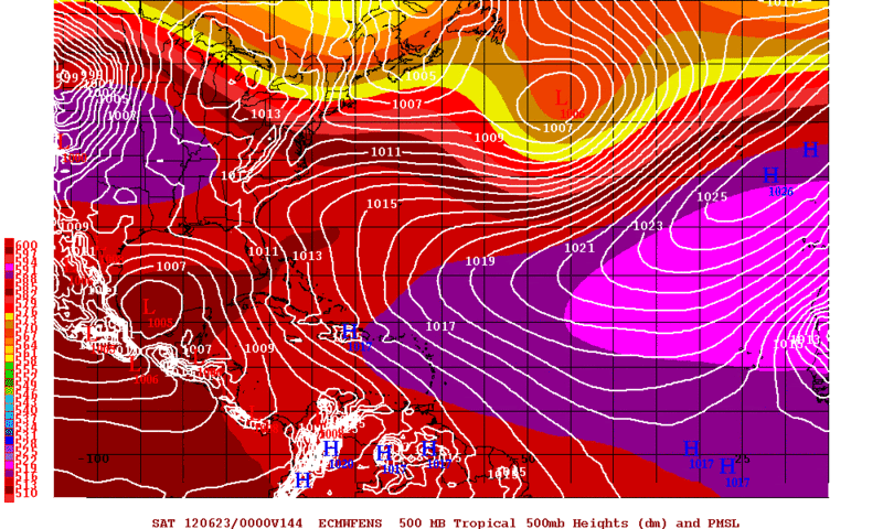
0zECMWF Ensemble Means are showing a 1005mb Low in the BOC by Friday Evening.
0 likes
The following post is NOT an official forecast and should not be used as such. It is just the opinion of the poster and may or may not be backed by sound meteorological data. It is NOT endorsed by any professional institution including storm2k.org For Official Information please refer to the NHC and NWS products.
-
cycloneye
- Admin
- Posts: 149275
- Age: 69
- Joined: Thu Oct 10, 2002 10:54 am
- Location: San Juan, Puerto Rico
Re: NW Carribean / Southern GOM / BOC
12z GFS is more weaker than in past runs and also more south in track to Mexico.

0 likes
Visit the Caribbean-Central America Weather Thread where you can find at first post web cams,radars
and observations from Caribbean basin members Click Here
and observations from Caribbean basin members Click Here
Who is online
Users browsing this forum: No registered users and 113 guests