Posible GOM development?

This is the general tropical discussion area. Anyone can take their shot at predicting a storms path.

Moderator: S2k Moderators

Forum rules

The posts in this forum are NOT official forecasts and should not be used as such. They are just the opinion of the poster and may or may not be backed by sound meteorological data. They are NOT endorsed by any professional institution or STORM2K. For official information, please refer to products from the National Hurricane Center and National Weather Service.

Help Support Storm2K
Message
Author
User avatar
NDG
S2K Supporter
S2K Supporter
Posts: 15446
Joined: Sun Jul 09, 2006 10:14 pm
Location: Orlando, FL

Re: Posible GOM development?

#201 Postby NDG » Fri Sep 25, 2015 3:44 pm

northjaxpro wrote:
Weatherwatcher98 wrote:Not even looking at Models until "something" is there. With all due respect Models have struggled to say the least this season.


I am totally with you about this. I still beleie that overall conditions will not allow for a mature healthy tropical cyclone next week. it will be a sheared, lopsided system at best should development occurs. The models have struggled big time this season with the hostile conditions with shear throughout the North Atlantic basin thanks to the strong El Nino this season.


Yes but the struggle of the models has been in the mid range to long range forecast. We are within 2 days of the vorticity moving out of the Yucatan Peninsula in the southern GOM with both the GFS and Euro not painting a pretty picture in the upper levels.
If anything in our part of the Atlantic it has been that the upper levels end up being more hostile than forecasted by the models, there has not been a surprise of a system developing without the models showing it.
0 likes   

User avatar
northjaxpro
S2K Supporter
S2K Supporter
Posts: 8900
Joined: Mon Sep 27, 2010 11:21 am
Location: Jacksonville, FL

Re: Posible GOM development?

#202 Postby northjaxpro » Fri Sep 25, 2015 3:49 pm

NDG wrote:
northjaxpro wrote:
Weatherwatcher98 wrote:Not even looking at Models until "something" is there. With all due respect Models have struggled to say the least this season.


I am totally with you about this. I still beleie that overall conditions will not allow for a mature healthy tropical cyclone next week. it will be a sheared, lopsided system at best should development occurs. The models have struggled big time this season with the hostile conditions with shear throughout the North Atlantic basin thanks to the strong El Nino this season.


Yes but the struggle of the models has been in the mid range to long range forecast. We are within 2 days of the vorticity moving out of the Yucatan Peninsula in the southern GOM with both the GFS and Euro not painting a pretty picture in the upper levels.
If anything in our part of the Atlantic it has been that the upper levels end up being more hostile than forecasted by the models, there has not been a surprise of a system developing without the models showing it.


:uarrow: This is a good observation NDG . But, even if this potential system tries to spin up , I think by Tuesday shear values look to be rather unfavorable based on the analysis I saw from earlier today. But, it is a system in the GOM and once it forms, of course we will watch it very closely just in case models are wrong and shear not analyzed as bad as it is in the 5 day range.
0 likes   
NEVER, EVER SAY NEVER in the tropics and weather in general, and most importantly, with life itself!!

________________________________________________________________________________________

Fay 2008 Beryl 2012 Debby 2012 Colin 2016 Hermine 2016 Julia 2016 Matthew 2016 Irma 2017 Dorian 2019

User avatar
ronjon
Category 5
Category 5
Posts: 4822
Joined: Fri Aug 19, 2005 5:17 pm
Location: Hernando Beach, FL

Re: Posible GOM development?

#203 Postby ronjon » Fri Sep 25, 2015 3:50 pm

Yeah NDG..big ole sloppy sheared system that just might make it to low end TS strength - and we'll all be glued to the board over this pathetic system in this El Nino year, lol.
0 likes   

Weatherwatcher98
Category 1
Category 1
Posts: 346
Joined: Sat Sep 12, 2015 10:53 am

Re: Posible GOM development?

#204 Postby Weatherwatcher98 » Fri Sep 25, 2015 3:52 pm

NDG wrote:
northjaxpro wrote:
Weatherwatcher98 wrote:Not even looking at Models until "something" is there. With all due respect Models have struggled to say the least this season.


I am totally with you about this. I still beleie that overall conditions will not allow for a mature healthy tropical cyclone next week. it will be a sheared, lopsided system at best should development occurs. The models have struggled big time this season with the hostile conditions with shear throughout the North Atlantic basin thanks to the strong El Nino this season.


Yes but the struggle of the models has been in the mid range to long range forecast. We are within 2 days of the vorticity moving out of the Yucatan Peninsula in the southern GOM with both the GFS and Euro not painting a pretty picture in the upper levels.
If anything in our part of the Atlantic it has been that the upper levels end up being more hostile than forecasted by the models, there has not been a surprise of a system developing without the models showing it.
I think that was my Point :)
0 likes   
Personal Forecast Disclaimer:
The posts in this forum are NOT official forecast and should not be used as such. They are just the opinion of the poster and may or may not be backed by sound meteorological data. They are NOT endorsed by any professional institution or storm2k.org. For official information, please refer to the NHC and NWS products.

User avatar
wxman57
Moderator-Pro Met
Moderator-Pro Met
Posts: 22979
Age: 67
Joined: Sat Jun 21, 2003 8:06 pm
Location: Houston, TX (southwest)

Re: Posible GOM development?

#205 Postby wxman57 » Fri Sep 25, 2015 3:53 pm

Weatherwatcher98 wrote:Not even looking at Models until "something" is there. With all due respect Models have struggled to say the least this season.


The models are very useful prior to development. While they may not initialize the relatively small disturbance well, they do handle the general flow pattern quite well, allowing the meteorologist to identify the most likely track. That's why I study the models very closely prior to development.
0 likes   

User avatar
ronjon
Category 5
Category 5
Posts: 4822
Joined: Fri Aug 19, 2005 5:17 pm
Location: Hernando Beach, FL

Re: Posible GOM development?

#206 Postby ronjon » Fri Sep 25, 2015 3:57 pm

Actually looking over the 12z GFS 200 mb charts, there is a tiny anticyclone over the NE Yuc at 72 hrs which expands over the SE GOM with time. If the low developed off the NE coast of the Yuc as opposed to the NW coast of the Yuc, it would have much better tropical development chances.
0 likes   

Weatherwatcher98
Category 1
Category 1
Posts: 346
Joined: Sat Sep 12, 2015 10:53 am

Re: Posible GOM development?

#207 Postby Weatherwatcher98 » Fri Sep 25, 2015 3:58 pm

wxman57 wrote:
Weatherwatcher98 wrote:Not even looking at Models until "something" is there. With all due respect Models have struggled to say the least this season.


The models are very useful prior to development. While they may not initialize the relatively small disturbance well, they do handle the general flow pattern quite well, allowing the meteorologist to identify the most likely track. That's why I study the models very closely prior to development.
I agree but they seem less accurate this season compared to others. Is El Nino to blame?
0 likes   
Personal Forecast Disclaimer:
The posts in this forum are NOT official forecast and should not be used as such. They are just the opinion of the poster and may or may not be backed by sound meteorological data. They are NOT endorsed by any professional institution or storm2k.org. For official information, please refer to the NHC and NWS products.

Weatherwatcher98
Category 1
Category 1
Posts: 346
Joined: Sat Sep 12, 2015 10:53 am

Re: Posible GOM development?

#208 Postby Weatherwatcher98 » Fri Sep 25, 2015 3:59 pm

wxman57 wrote:
Weatherwatcher98 wrote:Not even looking at Models until "something" is there. With all due respect Models have struggled to say the least this season.


The models are very useful prior to development. While they may not initialize the relatively small disturbance well, they do handle the general flow pattern quite well, allowing the meteorologist to identify the most likely track. That's why I study the models very closely prior to development.
Also I am curious why the NHC with all due respect is mentioning an Area or potential "system" that has not formed so early on?? I have not witnessed this in the past.
0 likes   
Personal Forecast Disclaimer:
The posts in this forum are NOT official forecast and should not be used as such. They are just the opinion of the poster and may or may not be backed by sound meteorological data. They are NOT endorsed by any professional institution or storm2k.org. For official information, please refer to the NHC and NWS products.

User avatar
northjaxpro
S2K Supporter
S2K Supporter
Posts: 8900
Joined: Mon Sep 27, 2010 11:21 am
Location: Jacksonville, FL

Re: Posible GOM development?

#209 Postby northjaxpro » Fri Sep 25, 2015 4:05 pm

wxman57 wrote:
Weatherwatcher98 wrote:Not even looking at Models until "something" is there. With all due respect Models have struggled to say the least this season.


The models are very useful prior to development. While they may not initialize the relatively small disturbance well, they do handle the general flow pattern quite well, allowing the meteorologist to identify the most likely track. That's why I study the models very closely prior to development.


Yeah, excellent point wxman57. The models may not be performing well in medium to long range this season, but they do serve as a critical main resource for analyzing potential tracks for tropical cyclones. Definitely can't reduce the role models serve in that capacity for sure.
0 likes   
NEVER, EVER SAY NEVER in the tropics and weather in general, and most importantly, with life itself!!

________________________________________________________________________________________

Fay 2008 Beryl 2012 Debby 2012 Colin 2016 Hermine 2016 Julia 2016 Matthew 2016 Irma 2017 Dorian 2019

Dean4Storms
S2K Supporter
S2K Supporter
Posts: 6358
Age: 62
Joined: Sun Aug 31, 2003 1:01 pm
Location: Miramar Bch. FL

Re: Re:

#210 Postby Dean4Storms » Fri Sep 25, 2015 4:08 pm

Steve wrote:
LarryWx wrote:
Steve wrote:N2FSU,

Can you get a rainfall estimate map from wherever you run that version of the ECMWF through 144?


Are you looking for a particular location/ I can't post the map but it shows 3" for Pensacola.


Nah, that's cool. I had seen the GFS and was wondering if the ecmwf had a map showing ptot through the 144 hour mark for the gulf. I rarely look at the Euro beyond surface and don't have great access to any of its derived products.


Strangely enough the 12z ECM is showing less rain for the FL Panhandle from now to 144 hours. With Tally around an inch!
0 likes   

User avatar
NDG
S2K Supporter
S2K Supporter
Posts: 15446
Joined: Sun Jul 09, 2006 10:14 pm
Location: Orlando, FL

#211 Postby NDG » Fri Sep 25, 2015 4:09 pm

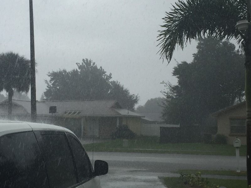
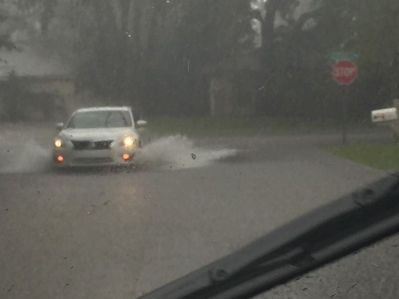
This is some of the heavy tropical rains some of you east of MS River valley in the SE US will be dealing with next week, I just picked up 1.5" in just half an hour flooding some low area streets in my neighborhood.

Image
Image
0 likes   

User avatar
northjaxpro
S2K Supporter
S2K Supporter
Posts: 8900
Joined: Mon Sep 27, 2010 11:21 am
Location: Jacksonville, FL

Re: Posible GOM development?

#212 Postby northjaxpro » Fri Sep 25, 2015 4:13 pm

Weatherwatcher98 wrote:
wxman57 wrote:
Weatherwatcher98 wrote:Not even looking at Models until "something" is there. With all due respect Models have struggled to say the least this season.


The models are very useful prior to development. While they may not initialize the relatively small disturbance well, they do handle the general flow pattern quite well, allowing the meteorologist to identify the most likely track. That's why I study the models very closely prior to development.
Also I am curious why the NHC with all due respect is mentioning an Area or potential "system" that has not formed so early on?? I have not witnessed this in the past.


Actually, I can recall a time when NHC mentioned a potential area of development well in advance due to excellent model support 7 days out in the long range. It happened in late May 2012 when Beryl developed off the S.E U.S. coast. It turned out the models were right a week in advance and Beryl evolved from subtropical development to transition to tropical and nearly became a hurricane as she made the loop SW to eventually make landfall here.

It is not a common occurance for NHC to declare a potential area for development that far in advance unless there is widespread agreement with the models depicting development out 7 days or so in advance.
0 likes   
NEVER, EVER SAY NEVER in the tropics and weather in general, and most importantly, with life itself!!

________________________________________________________________________________________

Fay 2008 Beryl 2012 Debby 2012 Colin 2016 Hermine 2016 Julia 2016 Matthew 2016 Irma 2017 Dorian 2019

User avatar
NDG
S2K Supporter
S2K Supporter
Posts: 15446
Joined: Sun Jul 09, 2006 10:14 pm
Location: Orlando, FL

Re: Posible GOM development?

#213 Postby NDG » Fri Sep 25, 2015 4:18 pm

ronjon wrote:Actually looking over the 12z GFS 200 mb charts, there is a tiny anticyclone over the NE Yuc at 72 hrs which expands over the SE GOM with time. If the low developed off the NE coast of the Yuc as opposed to the NW coast of the Yuc, it would have much better tropical development chances.


The models do a pretty good job forecasting the track of the vorticities at h85 within 72 hrs.
By Monday morning the vorticity is forecasted to be located in the middle of the GOM under 30-40 knot UL winds.
0 likes   

User avatar
tropicwatch
Category 5
Category 5
Posts: 3386
Age: 61
Joined: Sat Jun 02, 2007 10:01 am
Location: Panama City Florida
Contact:

#214 Postby tropicwatch » Fri Sep 25, 2015 4:20 pm

Well if a low forms in the Gulf of Mexico, I would say they have done a good job on this one. They have been indicating it for close to 10 days now.
0 likes   
Tropicwatch


Agnes 72', Eloise 75, Elena 85', Kate 85', Charley 86', Florence 88', Beryl 94', Dean 95', Erin 95', Opal 95', Earl 98', Georges 98', Ivan 2004', Arlene 2005', Dennis 2005', Ida 2009' Debby 2012' Irma 2017' Michael 2018'

User avatar
NDG
S2K Supporter
S2K Supporter
Posts: 15446
Joined: Sun Jul 09, 2006 10:14 pm
Location: Orlando, FL

#215 Postby NDG » Fri Sep 25, 2015 4:22 pm

Without a doubt a low pressure will form in the southern GOM, heck it may even start developing tomorrow over the Yucatan P before moving offshore on Sunday as the GFS has been showing, but it will not be pure tropical, more hybrid as mentioned before.
0 likes   

caneman
Category 5
Category 5
Posts: 1447
Joined: Fri Sep 05, 2014 5:44 am
Location: Clearwater Beach, Fl

#216 Postby caneman » Fri Sep 25, 2015 4:25 pm

Im not buying it ndg. Im not saying anything significant will develop but I am saying I don't believe models this year. Further, I have seen many high end ts's in the GOM with shear in place. Im in a wait and see mode.
0 likes   

User avatar
Ntxw
Storm2k Moderator
Storm2k Moderator
Posts: 22785
Joined: Wed Oct 21, 2009 6:34 pm
Location: DFW, Texas

Re: Posible GOM development?

#217 Postby Ntxw » Fri Sep 25, 2015 4:34 pm

Shear is on the increase over the Gulf of Mexico. You can see it with the thunderstorms blossoming and being blown. By tomorrow we should see it increase to 40-50 knots and more as ULL migrates to the Texas coast. As that happens lots of convection will expand across the eastern Gulf in a river of SW flow from the BOC stretching to the NGOM and Florida panhandle.

Image
0 likes   
The above post and any post by Ntxw is NOT an official forecast and should not be used as such. It is just the opinion of the poster and may or may not be backed by sound meteorological data. It is NOT endorsed by any professional institution including Storm2k. For official information, please refer to NWS products.

  Help support Storm2K!
Help Support Storm2K

Weatherwatcher98
Category 1
Category 1
Posts: 346
Joined: Sat Sep 12, 2015 10:53 am

Re: Posible GOM development?

#218 Postby Weatherwatcher98 » Fri Sep 25, 2015 4:42 pm

Thanks. But after this year I would think they would wait. Good points all around though. Nice board
0 likes   
Personal Forecast Disclaimer:
The posts in this forum are NOT official forecast and should not be used as such. They are just the opinion of the poster and may or may not be backed by sound meteorological data. They are NOT endorsed by any professional institution or storm2k.org. For official information, please refer to the NHC and NWS products.

User avatar
NDG
S2K Supporter
S2K Supporter
Posts: 15446
Joined: Sun Jul 09, 2006 10:14 pm
Location: Orlando, FL

Re:

#219 Postby NDG » Fri Sep 25, 2015 4:44 pm

caneman wrote:Im not buying it ndg. Im not saying anything significant will develop but I am saying I don't believe models this year. Further, I have seen many high end ts's in the GOM with shear in place. Im in a wait and see mode.


Like I said, the facts this year have been that the upper level environment turns out as bad if not worst than forecasted by the models in our part of the Atlantic since late July. If it would had been the other way around you would have had a point.
Yes, I have seen high end TS in the GOM but with only 20-30 knot UL winds not 40-60 knot winds as forecasted as the vorticity approaches the central and northern GOM. Another bad condition will be mid level shear which has been probably even more damaging as we saw with 94L a few days ago in the SW GOM.
0 likes   

Weatherwatcher98
Category 1
Category 1
Posts: 346
Joined: Sat Sep 12, 2015 10:53 am

Re:

#220 Postby Weatherwatcher98 » Fri Sep 25, 2015 5:07 pm

caneman wrote:Im not buying it ndg. Im not saying anything significant will develop but I am saying I don't believe models this year. Further, I have seen many high end ts's in the GOM with shear in place. Im in a wait and see mode.
This pretty much sums it up in my opinion

NWS Ruskin
LONG TERM (SATURDAY NIGHT - FRIDAY)...
FOR THE SECOND HALF OF THE WEEKEND...AN UPPER-LEVEL LOW WILL
REMAIN OVER THE SOUTH-CENTRAL U.S. WITH RIDGING EXTENDING ACROSS
THE FAR WESTERN ATLANTIC OCEAN. SURFACE HIGH PRESSURE OVER THE
NORTHEAST WILL SHIFT OUT INTO THE ATLANTIC ON SUNDAY AS A WEAK
AREA OF LOW PRESSURE EMERGES FROM THE YUCATAN PENINSULA. WIND FLOW
OVER OUR REGION WILL BE EASTERLY WITH PLENTY OF MOISTURE IN PLACE
(LATEST GFS SHOWS PRECIPITABLE WATER VALUES IN THE 2.30-INCH
RANGE)...SO WE SHOULD SEE SCATTERED TO NUMEROUS SHOWERS AND
THUNDERSTORMS ACROSS MUCH OF THE FORECAST AREA FOR SUNDAY
AFTERNOON WITH THE SEA BREEZE FORMING ALONG THE WEST COAST.

THE FORECAST FOR EARLY NEXT WEEK WILL BE LARGELY DEPENDENT ON THE
EVOLUTION OF THE SURFACE LOW CURRENTLY FORECAST TO MOVE INTO THE
CENTRAL GULF OF MEXICO AND MOVE TOWARD THE NORTH-EASTERN GULF
COAST REGION ON MONDAY AND TUESDAY. THE INHERENT UNCERTAINTY IN
THE POSITION OF THE LOW TRANSLATES TO UNCERTAINTY IN THE POSSIBLE
IMPACTS FOR OUR AREA. THE LATEST MODEL RUNS STILL SHOW OUR
FORECAST AREA TO BE ON THE EASTERN EDGE OF THIS SYSTEM...SO FOR
NOW WILL KEEP THE FORECAST SIMILAR TO THE PREVIOUS ONE...WITH THE
HIGHEST RAIN CHANCES OVER THE COASTAL WATERS. IF THIS SYSTEM ENDS
UP FARTHER EAST...THAT WILL MEAN HIGHER RAIN CHANCES FOR THE
FLORIDA PENINSULA. ON THE OTHER HAND...A TRACK MORE TO THE WEST
WOULD LEAVE US WITH A DRIER FORECAST. FOR WEDNESDAY INTO
THURSDAY...MODELS SHOW THIS SYSTEM AS A TROUGH PULLING AWAY TO THE
NORTHEAST WITH A MORE TYPICAL PATTERN THEN SETTING UP...ALTHOUGH
MODELS CONTINUE TO DIFFER ON OVERALL SYNOPTIC FEATURES AND THIS
CONTINUES INTO FRIDAY.
0 likes   
Personal Forecast Disclaimer:
The posts in this forum are NOT official forecast and should not be used as such. They are just the opinion of the poster and may or may not be backed by sound meteorological data. They are NOT endorsed by any professional institution or storm2k.org. For official information, please refer to the NHC and NWS products.


Return to “Talkin' Tropics”

Who is online

Users browsing this forum: hurricanes1234, Stratton23 and 43 guests