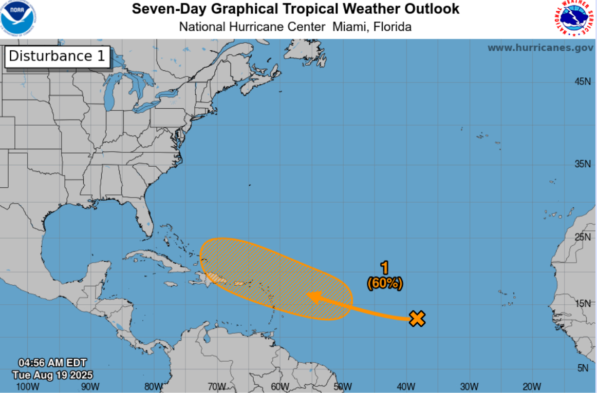
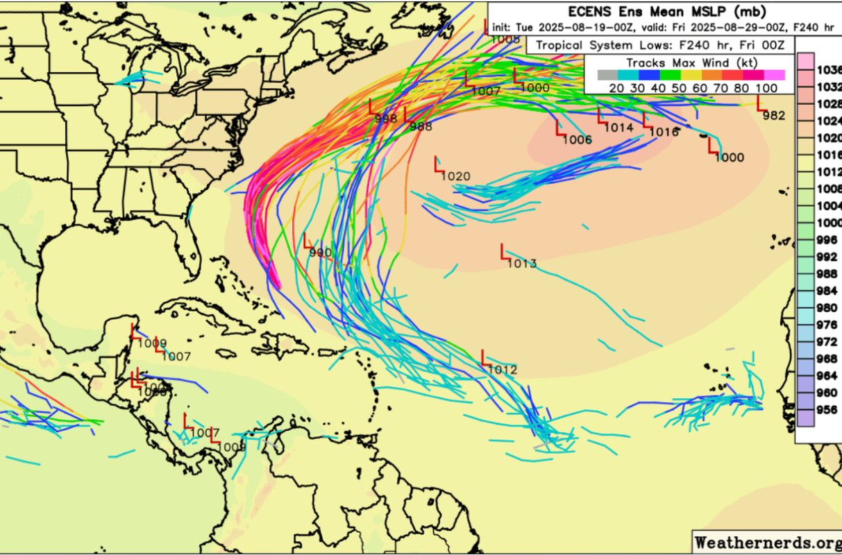
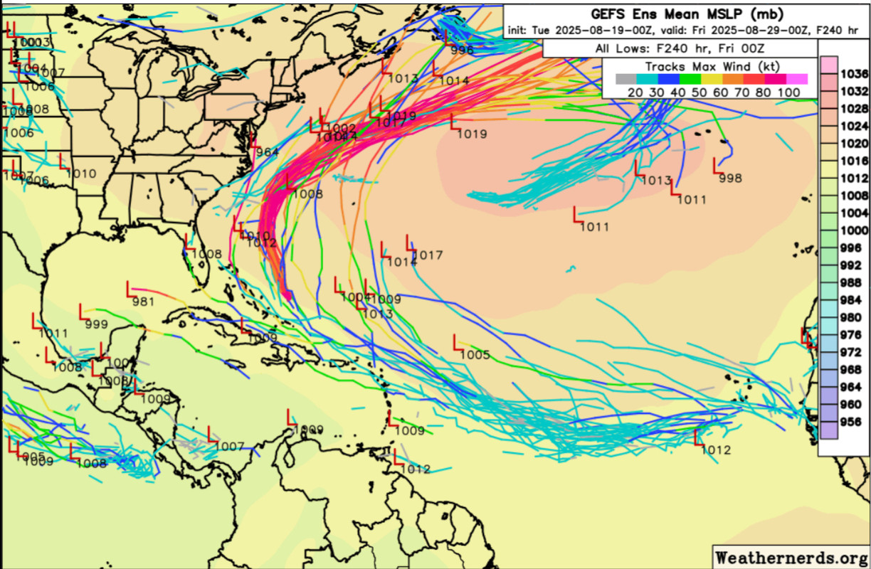
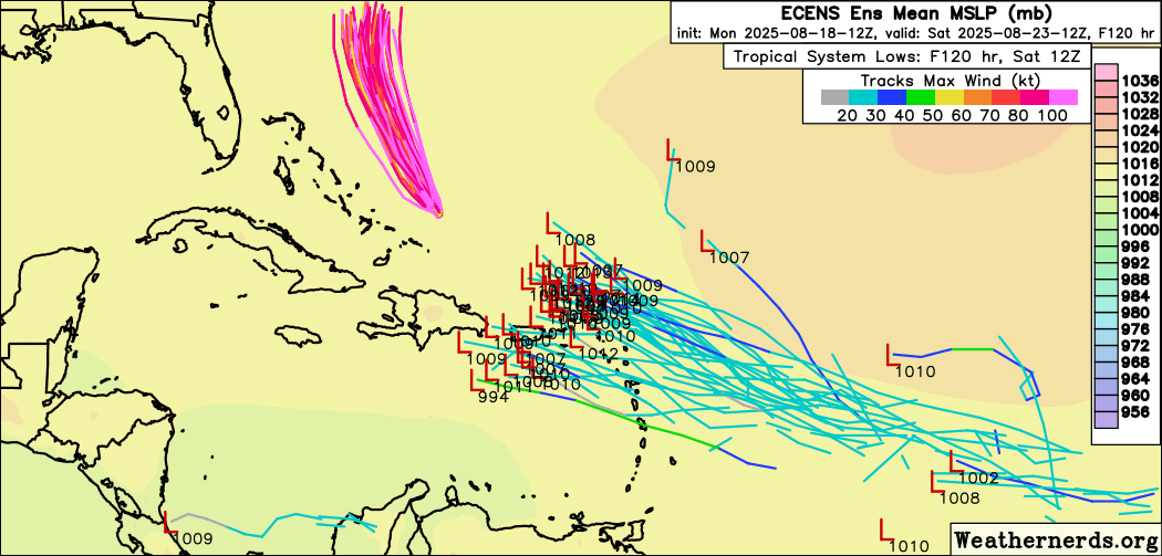
Tropical Wave in the Central Atlantic (10/60)

This is the general tropical discussion area. Anyone can take their shot at predicting a storms path.

Moderator: S2k Moderators

Forum rules

The posts in this forum are NOT official forecasts and should not be used as such. They are just the opinion of the poster and may or may not be backed by sound meteorological data. They are NOT endorsed by any professional institution or STORM2K. For official information, please refer to products from the National Hurricane Center and National Weather Service.

Help Support Storm2K
Message
Author
User avatar
cycloneye
Admin
Admin
Posts: 146154
Age: 69
Joined: Thu Oct 10, 2002 10:54 am
Location: San Juan, Puerto Rico

Re: Tropical Wave in the Central Atlantic (10/60)

#201 Postby cycloneye » Mon Aug 18, 2025 6:41 pm

Tropical Atlantic:
A tropical wave located over the central tropical Atlantic is
producing some disorganized showers and thunderstorms. Environmental
conditions appear conducive for gradual development of this system,
and a tropical depression could form toward the end of the week.
This system should move westward to west-northwestward at about 20
mph across the central tropical Atlantic and approach the vicinity
of the Leeward Islands on Friday.
* Formation chance through 48 hours...low...10 percent.
* Formation chance through 7 days...medium...60 percent.


Image
3 likes   
Visit the Caribbean-Central America Weather Thread where you can find at first post web cams,radars
and observations from Caribbean basin members Click Here

User avatar
eastcoastFL
Category 5
Category 5
Posts: 3933
Age: 43
Joined: Thu Apr 12, 2007 12:29 pm
Location: Palm City, FL

Re: Tropical Wave in the Central Atlantic (10/60)

#202 Postby eastcoastFL » Mon Aug 18, 2025 6:49 pm

SFLcane wrote:12z euro ensembles..

https://i.postimg.cc/xdQp13Rc/vvvv.png


Looks like the furthest south track is the strongest. At least as best I can tell from the bunch. Which also wouldn't be great for the Caribbean and possibly the Gulf of Mexico.
0 likes   
Personal Forecast Disclaimer:
The posts in this forum are NOT official forecast and should not be used as such. They are just the opinion of the poster and may or may not be backed by sound meteorological data. They are NOT endorsed by any professional institution or storm2k.org. For official information, please refer to the NHC and NWS products.

zhukm29
Category 1
Category 1
Posts: 283
Joined: Tue Aug 28, 2018 2:37 pm

Re: Tropical Wave in the Central Atlantic (10/60)

#203 Postby zhukm29 » Mon Aug 18, 2025 6:51 pm

An absolute chonker wave just splashed down behind the 10/60 wave. Curious to see if it will have any effect on the wave in front.

Image
2 likes   

Tekken_Guy
Tropical Storm
Tropical Storm
Posts: 136
Joined: Fri Sep 01, 2017 8:08 pm

Re: Tropical Wave in the Central Atlantic (10/60)

#204 Postby Tekken_Guy » Mon Aug 18, 2025 6:52 pm

Kazmit wrote:Wouldn’t be a happy hour GFS without the devastation of a major US city


Or our annual “destroy NYC” run. Fiona and Lee all teased an NYC hit.
5 likes   

Stratton23
Category 5
Category 5
Posts: 2631
Joined: Fri Jul 21, 2023 10:59 pm
Location: Katy, Tx

Re: Tropical Wave in the Central Atlantic (10/60)

#205 Postby Stratton23 » Mon Aug 18, 2025 7:02 pm

Convection has managed to persist all day in the area where their is some low level spin south of 10 N or the south end of the wave, the part of the wave that the GFS and Euro develop really doesnt have much convective activity at all, im definitely wary that they are picking up on the wrong vort max
0 likes   

User avatar
HurricaneBelle
S2K Supporter
S2K Supporter
Posts: 1185
Joined: Sun Aug 27, 2006 6:12 pm
Location: Clearwater, FL

Re: Tropical Wave in the Central Atlantic (10/60)

#206 Postby HurricaneBelle » Mon Aug 18, 2025 8:12 pm

BobHarlem wrote:Don't confuse this 18z run here with Erin, with the OBX near miss, but it goes for long island after this.

https://i.imgur.com/yxO9ZSN.png


Hey it's my namesake! (but stronger)
0 likes   

txwxwatcher
Tropical Storm
Tropical Storm
Posts: 101
Joined: Thu Feb 18, 2010 10:00 pm

Re: Tropical Wave in the Central Atlantic (0/50)

#207 Postby txwxwatcher » Mon Aug 18, 2025 9:13 pm

LAF92 wrote:
Stratton23 wrote:GFS looks like its still developing the northern portion of the wave, based on satellite imagery, i have my doubts that global models are seeing this in real time all that good, if this southern portion becomes the dominant low, that will have absolutely significant effects on a track

That’s what I was thinking. Also the 12z ICON has a strong trough bring a front to the gulf coast, I’m not buying that on August


Well, for what it’s worth we have a summer front arriving in Houston on Thursday.

https://abc13.com/post/houston-weather- ... ons/39346/
0 likes   

User avatar
Jr0d
S2K Supporter
S2K Supporter
Posts: 1434
Joined: Tue Aug 27, 2019 10:52 am
Location: Cayo Hueso

Re: Tropical Wave in the Central Atlantic (10/60)

#208 Postby Jr0d » Mon Aug 18, 2025 10:35 pm

Tekken_Guy wrote:
Kazmit wrote:Wouldn’t be a happy hour GFS without the devastation of a major US city


Or our annual “destroy NYC” run. Fiona and Lee all teased an NYC hit.


We really need to make a tally of GFS runs that destroy major population areas each season. Seems like it happens 100+ times each season with many of the long range storms being phantoms.

Unfortunately that 0.1% of the time it is on to a storm, few of us take it seriously.
0 likes   

User avatar
StPeteMike
Category 2
Category 2
Posts: 650
Joined: Thu Jun 07, 2018 11:26 pm

Re: Tropical Wave in the Central Atlantic (10/60)

#209 Postby StPeteMike » Mon Aug 18, 2025 11:01 pm

Stubborn AOI, likely another full day tomorrow of guessing game on which area of vorticity gains the upper hand. Still leaning on the southern end, the convection has been persistent all day.
0 likes   
The above post is not official and should not be used as such. It is the opinion of the poster and may or may not be backed by sound meteorological data. It is not endorsed by any professional institution or storm2k.org. For official information, please refer to the NHC and NWS products.

Pelicane
Tropical Storm
Tropical Storm
Posts: 120
Joined: Tue Sep 13, 2022 1:52 pm
Location: Lafayette, Louisiana

Re: Tropical Wave in the Central Atlantic (10/60)

#210 Postby Pelicane » Mon Aug 18, 2025 11:11 pm

Looks like the GFS is coming into consensus with the other models in showing a disorganized wave within 5 days. Great news for the islands if it verifies.
3 likes   

User avatar
Hurricaneman
Category 5
Category 5
Posts: 7390
Age: 45
Joined: Tue Aug 31, 2004 3:24 pm
Location: central florida

Re: Tropical Wave in the Central Atlantic (10/60)

#211 Postby Hurricaneman » Mon Aug 18, 2025 11:20 pm

Seems to want to wait until it’s in the Turks and Caicos before tropical cyclone development happens the last 2 runs of the GFS
0 likes   

LarryWx
S2K Supporter
S2K Supporter
Posts: 6465
Joined: Sun Sep 07, 2003 2:04 pm
Location: GA

Re: Tropical Wave in the Central Atlantic (10/60)

#212 Postby LarryWx » Mon Aug 18, 2025 11:20 pm

Latest UKMET (0Z) still pretty weak and a little west of 12Z though still not far W of Bermuda:

NEW TROPICAL CYCLONE FORECAST TO DEVELOP AFTER 102 HOURS
FORECAST POSITION AT T+102 : 20.6N 64.4W

LEAD CENTRAL MAXIMUM WIND
VERIFYING TIME TIME POSITION PRESSURE (MB) SPEED (KNOTS)
-------------- ---- -------- ------------- -------------
1200UTC 23.08.2025 108 21.3N 65.7W 1010 28
0000UTC 24.08.2025 120 22.9N 67.2W 1011 30
1200UTC 24.08.2025 132 24.5N 68.2W 1011 35
0000UTC 25.08.2025 144 26.9N 68.9W 1011 35
1200UTC 25.08.2025 156 29.9N 68.4W 1012 35
0000UTC 26.08.2025 168 33.3N 67.2W 1011 31
0 likes   
Personal Forecast Disclaimer:
The posts in this forum are NOT official forecasts and should not be used as such. They are just the opinion of the poster and may or may not be backed by sound meteorological data. They are NOT endorsed by any professional institution or storm2k.org. For official information, please refer to the NHC and NWS products.

Stratton23
Category 5
Category 5
Posts: 2631
Joined: Fri Jul 21, 2023 10:59 pm
Location: Katy, Tx

Re: Tropical Wave in the Central Atlantic (10/60)

#213 Postby Stratton23 » Mon Aug 18, 2025 11:32 pm

Despite the GFS recurving this run, Im growing increasingly skeptical that the global models are not seeing whats happening on the southern end of the wave, real time their has been a burst of new convection around the low level spin or around 8 N or so, and that convection is holding up pretty good even in the diurnal minimum cycle, this screams model whiff, im watching for a much farther south scenario to unfold if this area persists overnight
2 likes   

txwxwatcher
Tropical Storm
Tropical Storm
Posts: 101
Joined: Thu Feb 18, 2010 10:00 pm

Re: Tropical Wave in the Central Atlantic (10/60)

#214 Postby txwxwatcher » Mon Aug 18, 2025 11:50 pm

Stratton23 wrote:Despite the GFS recurving this run, Im growing increasingly skeptical that the global models are not seeing whats happening on the southern end of the wave, real time their has been a burst of new convection around the low level spin or around 8 N or so, and that convection is holding up pretty good even in the diurnal minimum cycle, this screams model whiff, im watching for a much farther south scenario to unfold if this area persists overnight


Or maybe, just maybe, the models are actually depicting what is likely to happen.
3 likes   

Brent
S2K Supporter
S2K Supporter
Posts: 38113
Age: 37
Joined: Sun May 16, 2004 10:30 pm
Location: Tulsa Oklahoma
Contact:

Re: Tropical Wave in the Central Atlantic (10/60)

#215 Postby Brent » Mon Aug 18, 2025 11:54 pm

I'm gonna need a lot more evidence to believe that anything other than following Erin out to sea happens honestly

Most of the EPS members have been doing that anyway
3 likes   
#neversummer

Pelicane
Tropical Storm
Tropical Storm
Posts: 120
Joined: Tue Sep 13, 2022 1:52 pm
Location: Lafayette, Louisiana

Re: Tropical Wave in the Central Atlantic (10/60)

#216 Postby Pelicane » Tue Aug 19, 2025 12:01 am

txwxwatcher wrote:
Stratton23 wrote:Despite the GFS recurving this run, Im growing increasingly skeptical that the global models are not seeing whats happening on the southern end of the wave, real time their has been a burst of new convection around the low level spin or around 8 N or so, and that convection is holding up pretty good even in the diurnal minimum cycle, this screams model whiff, im watching for a much farther south scenario to unfold if this area persists overnight


Or maybe, just maybe, the models are actually depicting what is likely to happen.


It's never unwise to be cautious and skeptical, models have whiffed badly before. Dorian is a prime example of that, and that happened in a similar location and time of year. This is a tricky setup with a large, elongated wave but there's plenty of moisture available for it, just a question of how favorable the upper levels will be. The 12z run earlier today had a H making landfall in Florida, so we've already seen tons of variability with that today. It's best to watch it carefully until it's certain it'll head OTS or wither away.
3 likes   

Stratton23
Category 5
Category 5
Posts: 2631
Joined: Fri Jul 21, 2023 10:59 pm
Location: Katy, Tx

Re: Tropical Wave in the Central Atlantic (10/60)

#217 Postby Stratton23 » Tue Aug 19, 2025 12:16 am

txwxwatcher that certainly is possible too, but this particular area has been very persistent even into the diurnal cycle and their really hasnt been any convection anywhere else really , i just think its a situation in which models miss this
0 likes   

User avatar
Hurricaneman
Category 5
Category 5
Posts: 7390
Age: 45
Joined: Tue Aug 31, 2004 3:24 pm
Location: central florida

Re: Tropical Wave in the Central Atlantic (10/60)

#218 Postby Hurricaneman » Tue Aug 19, 2025 12:16 am

Seems as though it’s consolidating around 10n
0 likes   

Pelicane
Tropical Storm
Tropical Storm
Posts: 120
Joined: Tue Sep 13, 2022 1:52 pm
Location: Lafayette, Louisiana

Re: Tropical Wave in the Central Atlantic (10/60)

#219 Postby Pelicane » Tue Aug 19, 2025 12:41 am

Image

Image

Image

The lower levels definitely favor the bottom half currently, but there is disorganization the higher you go.

As it gains latitude, the current model consensus if for the bottom vortex maximum to rotate and become more aligned and dominant with the upper half of the wave axis.
1 likes   

User avatar
Blown Away
S2K Supporter
S2K Supporter
Posts: 10165
Joined: Wed May 26, 2004 6:17 am

Re: Tropical Wave in the Central Atlantic (10/60)

#220 Postby Blown Away » Tue Aug 19, 2025 4:30 am

Image
Image
00z ECENS
Image
00z GEFS

Little to no GEFS/ECENS support for the NHC 7 day orange area pointing WNW into SE Bahamas. All the ECENS recurve well E and many of the limited GEFS do too. NHC must be looking at some other factor? It wouldn’t shock me if NHC didn’t start backing off the 10/60% chance.
0 likes   
Hurricane Eye Experience: David 79, Irene 99, Frances 04, Jeanne 04, Wilma 05… Hurricane Brush Experience: Andrew 92, Erin 95, Floyd 99, Matthew 16, Irma 17, Ian 22, Nicole 22…


Return to “Talkin' Tropics”

Who is online

Users browsing this forum: duilaslol, Sps123 and 45 guests