Tropical Wave WSW of the Cabo Verde Islands (Is Invest 91L)
Moderator: S2k Moderators
Forum rules

The posts in this forum are NOT official forecasts and should not be used as such. They are just the opinion of the poster and may or may not be backed by sound meteorological data. They are NOT endorsed by any professional institution or STORM2K. For official information, please refer to products from the National Hurricane Center and National Weather Service.
Re: Tropical Wave WSW of the Cabo Verde Islands (30/70)
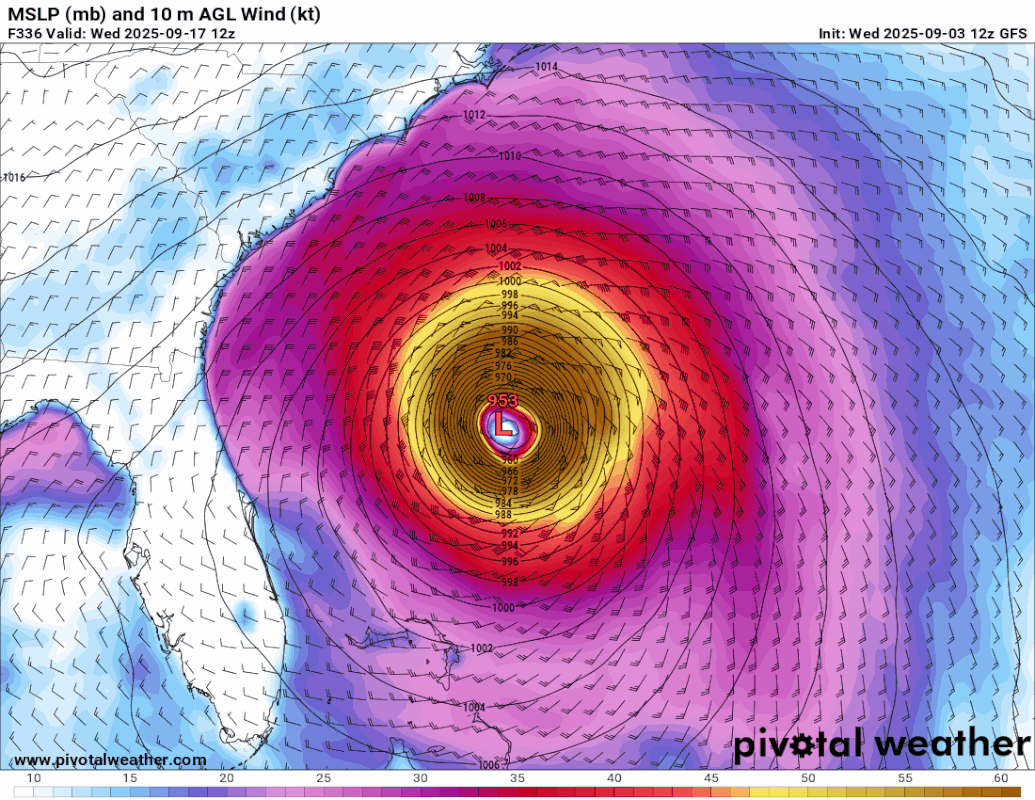
ULL over south carolina basically pulls it in right over the low country, near Edisto, Charleston gets the right front quad.
Last edited by BobHarlem on Wed Sep 03, 2025 12:11 pm, edited 1 time in total.
0 likes

Re: Tropical Wave WSW of the Cabo Verde Islands (30/70)
12z GFS +354h, 954 mb and the final frame before a landfall SE of Charleston.

0 likes
Re: Tropical Wave WSW of the Cabo Verde Islands (30/70)
Between the vast spread between all the ensembles of the various models, ULL and the TUTT and this you are probably going to see a lot of the phrase "low confidence" in future outlooks/discussions. If a system gets that far west, the ULL would pull it inland -- post landfall it gets to Illinois, but GFS maybe still has a poleward bias. This system just got a whole lot more interesting today.
2 likes
Re: Tropical Wave WSW of the Cabo Verde Islands (30/70)
12Z UKMET: N of 0Z…aiming for just N of Leewards
NEW TROPICAL CYCLONE FORECAST TO DEVELOP AFTER 96 HOURS
FORECAST POSITION AT T+ 96 : 13.8N 43.4W
LEAD CENTRAL MAXIMUM WIND
VERIFYING TIME TIME POSITION PRESSURE (MB) SPEED (KNOTS)
-------------- ---- -------- ------------- -------------
1200UTC 07.09.2025 96 13.8N 43.4W 1012 25
0000UTC 08.09.2025 108 13.9N 46.1W 1011 28
1200UTC 08.09.2025 120 13.9N 48.8W 1010 28
0000UTC 09.09.2025 132 14.3N 51.3W 1009 31
1200UTC 09.09.2025 144 15.6N 53.6W 1010 32
0000UTC 10.09.2025 156 16.8N 56.0W 1010 32
1200UTC 10.09.2025 168 17.8N 58.6W 1010 34
0 likes
Personal Forecast Disclaimer:
The posts in this forum are NOT official forecasts and should not be used as such. They are just the opinion of the poster and may or may not be backed by sound meteorological data. They are NOT endorsed by any professional institution or storm2k.org. For official information, please refer to the NHC and NWS products.
The posts in this forum are NOT official forecasts and should not be used as such. They are just the opinion of the poster and may or may not be backed by sound meteorological data. They are NOT endorsed by any professional institution or storm2k.org. For official information, please refer to the NHC and NWS products.
-
MGC

- S2K Supporter

- Posts: 5941
- Joined: Sun Mar 23, 2003 9:05 pm
- Location: Pass Christian MS, or what is left.
Re: Tropical Wave WSW of the Cabo Verde Islands (30/70)
Yeah, this could be a potential US hit. Might get a closed low by this weekend. Past GFS runs have been too fast and too far east. Could even impact islands. All depends on the upper pattern a week from now.......MGC
1 likes
-
Stratton23
- Category 5

- Posts: 3573
- Joined: Fri Jul 21, 2023 10:59 pm
- Location: Katy, Tx
Re: Tropical Wave WSW of the Cabo Verde Islands (30/70)
Euro 12z looks like its headed for the central leeward islands, farther south than 00z run through 7 days so fas
0 likes
Re: Tropical Wave South of the Cabo Verde Islands (30/70)
Pelicane wrote:Looks like Lorena in the EPAC will play a future role with this system. Her remnants seem to help form a cutoff low in the SE as potential future Gabrielle turns north. Important to watch since if Gabrielle trends far enough west and that low is strong enough it could pinwheel around it. Already happened on the 9/1 0z run of the GFS, albeit with a seperate feature.
If this is a US threat than it will come down to Gabrielle's speed and strength, and where that ULL is placed and how strong it is. You never want anything to cutoff down there when a hurricane is trying to head north.
Most of the time it goes to OTS and that's still imo the most likely solution, but the setup is there for trouble.
0 likes

Re: Tropical Wave WSW of the Cabo Verde Islands (30/70)
AutoPenalti wrote:GFS so far a repeat of Erin so far... maybe a couple of degrees further north of the Islands, still heading WNW. No trough in sight, wow.
https://i.imgur.com/Z7QZO9Z.png
More like Hugo.
0 likes
Igor 2010, Sandy 2012, Fay 2014, Gonzalo 2014, Joaquin 2015, Nicole 2016, Humberto 2019, Imelda 2025
I am only a tropical weather enthusiast. My predictions are not official and may or may not be backed by sound meteorological data. For official information, please refer to the NHC and NWS products.
I am only a tropical weather enthusiast. My predictions are not official and may or may not be backed by sound meteorological data. For official information, please refer to the NHC and NWS products.
-
Cachondo23
- Tropical Storm

- Posts: 131
- Joined: Wed May 25, 2022 5:56 am
Re: Tropical Wave WSW of the Cabo Verde Islands (30/70)
Yup, the new 12oz GFS will have a lot of talk on all social media, get ready. At least until 18oz…
1 likes
-
cycloneye

- Admin

- Posts: 149686
- Age: 69
- Joined: Thu Oct 10, 2002 10:54 am
- Location: San Juan, Puerto Rico
Re: Tropical Wave WSW of the Cabo Verde Islands (40/80)
Tropical Weather Outlook
NWS National Hurricane Center Miami FL
Issued by the NWS Weather Prediction Center College Park MD
200 PM EDT Wed Sep 3 2025
For the North Atlantic...Caribbean Sea and the Gulf of America:
Eastern Tropical Atlantic:
A tropical wave located over the eastern tropical Atlantic a few
hundred miles west-southwest of the Cabo Verde islands continues to
produce disorganized showers and thunderstorms. Environmental
conditions remain conducive for additional development of this
system during the next several days, and a tropical depression is
likely to form late this week or this weekend. This system is
expected to move westward to west-northwestward at around 15 mph
across the eastern and central tropical Atlantic into early next
week.
* Formation chance through 48 hours...medium...40 percent.
* Formation chance through 7 days...high...80 percent.
$$
Forecaster Bann

0 likes
Visit the Caribbean-Central America Weather Thread where you can find at first post web cams,radars
and observations from Caribbean basin members Click Here
and observations from Caribbean basin members Click Here
-
lsuhurricane
- Category 1

- Posts: 270
- Joined: Tue Aug 15, 2017 2:53 pm
Re: Tropical Wave WSW of the Cabo Verde Islands (40/80)
The GFS Ensembles are in complete disagreement with the operational, sending each member out to sea. Weird stuff.
0 likes
-
AutoPenalti
- Category 5
- Posts: 4091
- Age: 29
- Joined: Mon Aug 17, 2015 4:16 pm
- Location: Ft. Lauderdale, Florida
Re: Tropical Wave WSW of the Cabo Verde Islands (40/80)
12z Euro further South.
0 likes
The posts in this forum are NOT official forecasts and should not be used as such. They are just the opinion of the poster and may or may not be backed by sound meteorological data. They are NOT endorsed by any professional institution or STORM2K. For official information, please refer to products from the NHC and NWS.
Model Runs Cheat Sheet:
GFS (5:30 AM/PM, 11:30 AM/PM)
HWRF, GFDL, UKMET, NAVGEM (6:30-8:00 AM/PM, 12:30-2:00 AM/PM)
ECMWF (1:45 AM/PM)
TCVN is a weighted averaged
-
TomballEd
- Category 5
- Posts: 1317
- Age: 62
- Joined: Wed Aug 16, 2023 4:52 pm
- Location: Spring/Klein area, not Tomball
Re: Tropical Wave WSW of the Cabo Verde Islands (40/80)
lsuhurricane wrote:The GFS Ensembles are in complete disagreement with the operational, sending each member out to sea. Weird stuff.
I know ensemble models used to be run at lower resolution to reduce computer demand. I believe the Euro ensembles are the same resolution as the op, or there is no need for a control run member.
I suspect GFS is still run at a lower resolution. If the control run is different it suggests lower resolution changes the model solution. I think some PPV boards have control runs (sane initialization as the op) identified.
0 likes
-
Stratton23
- Category 5
- Posts: 3573
- Joined: Fri Jul 21, 2023 10:59 pm
- Location: Katy, Tx
Re: Tropical Wave WSW of the Cabo Verde Islands (40/80)
Euro is weaker after interaction with the islands, and recurves in the bahamas, but just barely misses florida, I dont think the 12z ensembles will reflect these changes in the global model runs, typically have to wait another cycle or two to see if ensembles change
0 likes
Re: Tropical Wave WSW of the Cabo Verde Islands (40/80)
Wow the 12Z ECMWF has a TS moving WNW in the vicinity of Dominica and Martinique.
0 likes
Re: Tropical Wave WSW of the Cabo Verde Islands (40/80)
12z Euro gets into the Caribbean and goes for Puerto Rico. Really weak though. Then gets caught up in the DR some, which rips it apart. It does get into the Bahamas later though, and it goes up along the east side of the ULL and out on the Euro. Set the model windshield wipers on max for the next few days.


0 likes
-
MEANINGLESS_NUMBERS
- Category 2

- Posts: 503
- Joined: Mon Nov 02, 2020 1:43 pm
Re: Tropical Wave WSW of the Cabo Verde Islands (30/70)
BobHarlem wrote:ULL over south carolina basically pulls it in right over the low country, near Edisto, Charleston gets the right front quad.
https://i.postimg.cc/g2RbS1bg/floop-gfs-2025090312-sfcwind-mslp-swatl.gif
That looks expensive.
1 likes
Emily '87, Felix '95, Gert '99, Fabian '03, Humberto '19, Paulette '20, Teddy '20, Fiona '22, Lee '23, Ernesto '24, Humberto/Imelda '25
-
Cachondo23
- Tropical Storm
- Posts: 131
- Joined: Wed May 25, 2022 5:56 am
Re: Tropical Wave WSW of the Cabo Verde Islands (40/80)
BobHarlem wrote:12z Euro gets into the Caribbean and goes for Puerto Rico. Really weak though. Then gets caught up in the DR some, which rips it apart. It does get into the Bahamas later though, and it goes up along the east side of the ULL and out on the Euro. Set the model windshield wipers on max for the next few days.
https://i.imgur.com/ORjmkmN.png
https://i.imgur.com/PkwOXXc.png
If it reaches the Leeward Islands it might encounter shear and maybe some dry air but after it pases those islands and continues in a NW direction, those waters are prime in the Caribbean Sea with 30C and some spots in the 31sC!
0 likes
-
ScottNAtlanta

- Category 5
- Posts: 2535
- Joined: Sat May 25, 2013 3:11 pm
- Location: Atlanta, GA
Re: Tropical Wave WSW of the Cabo Verde Islands (40/80)
Just something to remember...
There is a fine line between a TUTT that causes shear and a TUTT that ventilates a storm. Each causes quite the opposite outcome.
There is a fine line between a TUTT that causes shear and a TUTT that ventilates a storm. Each causes quite the opposite outcome.
4 likes
The posts in this forum are NOT official forecast and should not be used as such. They are just the opinion of the poster and may or may not be backed by sound meteorological data. They are NOT endorsed by any professional institution or storm2k.org. For official information, please refer to the NHC and NWS products.
-
jlauderdal
- S2K Supporter
- Posts: 7240
- Joined: Wed May 19, 2004 5:46 am
- Location: NE Fort Lauderdale
- Contact:
Re: Tropical Wave WSW of the Cabo Verde Islands (40/80)
lsuhurricane wrote:The GFS Ensembles are in complete disagreement with the operational, sending each member out to sea. Weird stuff.
At this range, ensembles or bust.
0 likes
Who is online
Users browsing this forum: No registered users and 257 guests