99L Invest,Comments,Sat Pics,Models Thread
Moderator: S2k Moderators
Forum rules
The posts in this forum are NOT official forecasts and should not be used as such. They are just the opinion of the poster and may or may not be backed by sound meteorological data. They are NOT endorsed by any professional institution or STORM2K. For official information, please refer to products from the National Hurricane Center and National Weather Service.
-
no advance
- Category 1

- Posts: 413
- Joined: Wed Aug 24, 2005 1:50 pm
- Location: merritt is.
-
Air Force Met
- Military Met

- Posts: 4372
- Age: 57
- Joined: Tue Jul 08, 2003 9:30 am
- Location: Roan Mountain, TN
~Floydbuster wrote:CapeVerdeWave wrote:There is some good news... conditions are expected to remain very unfavorable in parts of the northwest Caribbean and around Florida and the Bahamas. Shear is increasing in those areas. However, conditions are expected to become more favorable possibly in the western Gulf of Mexico.
Ok...
Shear is not currently favorable in the NW Caribbean...but should gradually become more favorable over the next few days. I don't think this is getting past Florida...
I agree. If ths develops it is probably an eastern GOM event. Nice upper level westerlies due to the frontal activity.
0 likes
-
Anonymous
I think this may be a system that moves west-northwest, to Cuba or the Yucatan Channel...and then gets pushed northeast into SW Florida by an incoming trough. The troughs become more dominent as you get more towards October/November. However, many past historic hurricanes have struck the USA in October/November. Hurricane Season 2005 is still very much alive and I am really, truly tired...however I think it would be wishful thinking on my part for me to say that the season is no longer a threat.
0 likes
-
jlauderdal
- S2K Supporter

- Posts: 7240
- Joined: Wed May 19, 2004 5:46 am
- Location: NE Fort Lauderdale
- Contact:
~Floydbuster wrote:I think this may be a system that moves west-northwest, to Cuba or the Yucatan Channel...and then gets pushed northeast into SW Florida by an incoming trough. The troughs become more dominent as you get more towards October/November. However, many past historic hurricanes have struck the USA in October/November. Hurricane Season 2005 is still very much alive and I am really, truly tired...however I think it would be wishful thinking on my part for me to say that the season is no longer a threat.
what intensity are you forecasting?
0 likes
- Portastorm
- Storm2k Moderator

- Posts: 9955
- Age: 63
- Joined: Fri Jul 11, 2003 9:16 am
- Location: Round Rock, TX
- Contact:
~Floydbuster wrote:I think this may be a system that moves west-northwest, to Cuba or the Yucatan Channel...and then gets pushed northeast into SW Florida by an incoming trough. The troughs become more dominent as you get more towards October/November. However, many past historic hurricanes have struck the USA in October/November. Hurricane Season 2005 is still very much alive and I am really, truly tired...however I think it would be wishful thinking on my part for me to say that the season is no longer a threat.
In a "normal" year, I would agree ... but heck, it was 108 degrees here in Austin yesterday in late September. This is by far not a normal year, or September for that matter.
The westerlies are far from being an active force below 30 degrees north.
0 likes
- Tampa Bay Hurricane
- Category 5

- Posts: 5597
- Age: 38
- Joined: Fri Jul 22, 2005 7:54 pm
- Location: St. Petersburg, FL
The following post is NOT an official forecast and should not be used as such. It is just the opinion of the poster and may or may not be backed by sound meteorological data. It is NOT endorsed by any professional institution including storm2k.org For Official Information please refer to the NHC and NWS products.
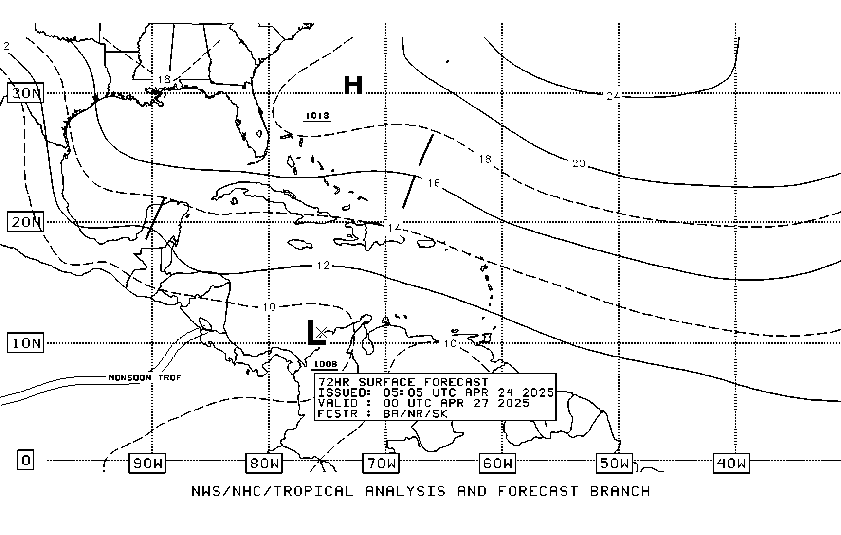
72 Hour
Stationary LOW off FL West Coast by THURSDAY according to
TAFB: ALSO NOTE THAT THE BURMUDA HIGHS EXTENT AS INDICATED
BY THE SQUIGGLY LINE IS FAR FROM FL. IF THIS PANS OUT THE
STORM WOULD BE A SW FL EVENT.

72 Hour
Stationary LOW off FL West Coast by THURSDAY according to
TAFB: ALSO NOTE THAT THE BURMUDA HIGHS EXTENT AS INDICATED
BY THE SQUIGGLY LINE IS FAR FROM FL. IF THIS PANS OUT THE
STORM WOULD BE A SW FL EVENT.

0 likes
-
WeatherEmperor
- S2K Supporter

- Posts: 4806
- Age: 42
- Joined: Thu Sep 04, 2003 2:54 pm
- Location: South Florida
inotherwords wrote:Bastardi is to meteorology what shockjocks are to radio.
I basically said that in another Thread last week..he's the "Howard Stern" of Metoroligy..Strange i use Stern as a comparison, he himself is headed to the Private Sector in January....on Satellite Radio....beyond the Reach of the FCC.
Anyways, I have a whole thing i could write about this, but i will just say that the more people get ticked off and write about him, the more attenion he gets....remember folks, there is no such thing as bad publicity.
I understand the Radio Station *may* have a Show on this whole Joe B/ Accuweather thing.....down the road...and i can't wait..i am a Pro Joe B guy and it looks like from the posts i've read...i am in the Minority with that opinion lol....but i never really cared too much for what people think about me....if i am there, i will state my opinion. It should be interesting to say the least lol
0 likes
- cajungal
- Category 5

- Posts: 2354
- Age: 49
- Joined: Sun Mar 14, 2004 9:34 pm
- Location: Schriever, Louisiana (60 miles southwest of New Orleans)
Channel 4 New Orleans meterologist Brad Panovich said with the cold fronts coming down, none of the systems will make it to LA or TX. But, I keep thinking of Juan which hit almost at Halloween and flooded Terrebonne Parish. Bob Breck had got fired from his job because he told everyone that Juan was going to be no threat to Louisiana. After some time passed, he managed to get his job back.skysummit wrote:It just doesn't end does it? I wonder if they'll change the colors of hurricane warnings and watches to green and red to keep with the Christmas spirit in a few months.
0 likes
Air Force Met wrote:~Floydbuster wrote:CapeVerdeWave wrote:There is some good news... conditions are expected to remain very unfavorable in parts of the northwest Caribbean and around Florida and the Bahamas. Shear is increasing in those areas. However, conditions are expected to become more favorable possibly in the western Gulf of Mexico.
Ok...
Shear is not currently favorable in the NW Caribbean...but should gradually become more favorable over the next few days. I don't think this is getting past Florida...
I agree. If ths develops it is probably an eastern GOM event. Nice upper level westerlies due to the frontal activity.
I am south of N.O. and many of the local Met's do agree that by around Friday we should have a cool front passing through. The only question from that point on will be the timing of the system coming out of the Caribbian. Cause they are not sure just how long the front will stay to our south.
0 likes
- skysummit
- S2K Supporter

- Posts: 5305
- Age: 50
- Joined: Tue Aug 31, 2004 11:09 pm
- Location: Ponchatoula, LA
- Contact:
cajungal wrote:Channel 4 New Orleans meterologist Brad Panovich said with the cold fronts coming down, none of the systems will make it to LA or TX. But, I keep thinking of Juan which hit almost at Halloween and flooded Terrebonne Parish. Bob Breck had got fired from his job because he told everyone that Juan was going to be no threat to Louisiana. After some time passed, he managed to get his job back.skysummit wrote:It just doesn't end does it? I wonder if they'll change the colors of hurricane warnings and watches to green and red to keep with the Christmas spirit in a few months.
Oh, I definately remember Juan. I was a kid then. We had over 4 feet of water in our home in Lockport in Lafourche Parish. The area just south of Lockport had over 10 feet of water. The water stayed for over a week and Halloween was cancelled.
0 likes
- cycloneye
- Admin

- Posts: 149505
- Age: 69
- Joined: Thu Oct 10, 2002 10:54 am
- Location: San Juan, Puerto Rico

Floater 1 is focused on 99L.

0 likes
Visit the Caribbean-Central America Weather Thread where you can find at first post web cams,radars
and observations from Caribbean basin members Click Here
and observations from Caribbean basin members Click Here
I hope this system does not effect Texas.
I do not like what ImpactWeather is saying and hope they are dead wrong.
They are saying another GOm hurricane threat next Saturday with a landfall between N Mexico and central Louisiana.
I do not like what ImpactWeather is saying and hope they are dead wrong.
They are saying another GOm hurricane threat next Saturday with a landfall between N Mexico and central Louisiana.
0 likes
The following post is NOT an official forecast and should not be used as such. It is just the opinion of the poster and may or may not be backed by sound meteorological data. It is NOT endorsed by any professional institution including storm2k.org For Official Information please refer to the NHC and NWS products.
That cold front could very well not make it given the crazy nature of the weather patterns we are experiencing. It is way hotter than normal here in the Houston area and it is insane to be under heat advisories this time of year but it is what it is. I would toss out any historical data on what storms typically do this time of the year and just watch and see...
0 likes
- DESTRUCTION5
- Category 5

- Posts: 4430
- Age: 44
- Joined: Wed Sep 03, 2003 11:25 am
- Location: Stuart, FL
- DESTRUCTION5
- Category 5

- Posts: 4430
- Age: 44
- Joined: Wed Sep 03, 2003 11:25 am
- Location: Stuart, FL
KatDaddy wrote:I hope this system does not effect Texas.
I do not like what ImpactWeather is saying and hope they are dead wrong.
They are saying another GOm hurricane threat next Saturday with a landfall between N Mexico and central Louisiana.
are the folks at ImpactWeather worth anything in terms of their predicting abilities? if they are, that REEEEEAAAAALLLLY sucks!!
0 likes
Who is online
Users browsing this forum: Google [Bot], Yellow Evan and 292 guests


