2021 Global Model Runs Discussion (Out thru day 16)

This is the general tropical discussion area. Anyone can take their shot at predicting a storms path.

Moderator: S2k Moderators

Forum rules

The posts in this forum are NOT official forecasts and should not be used as such. They are just the opinion of the poster and may or may not be backed by sound meteorological data. They are NOT endorsed by any professional institution or STORM2K. For official information, please refer to products from the National Hurricane Center and National Weather Service.

Help Support Storm2K
Message
Author
User avatar
WiscoWx02
Category 1
Category 1
Posts: 345
Age: 22
Joined: Sat Jul 31, 2021 8:09 pm
Location: Minnesota

Re: 2021 Global Model Runs Discussion (Out thru day 16)

#2021 Postby WiscoWx02 » Tue Oct 05, 2021 9:41 pm

Category5Kaiju wrote:
WiscoWx02 wrote:
Spacecoast wrote:12z ECENS: Remarkably unremarkable...
https://i.ibb.co/3NpDWGV/ecmjn.jpg


And surprise surprise, the GFS has dropped that Omar like storm. I'm becoming more and more confident with my idea that we have hit the drop off at this point. Models are about as exciting as an empty white room without windows.


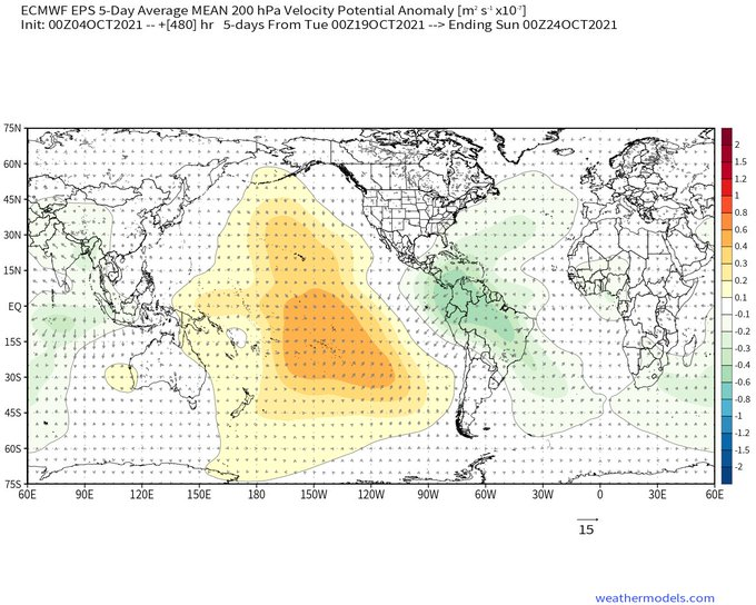
The reason why GFS drops any major Atlantic development anytime soon is because, well, not unsurprising, but the WPAC becomes a pezz dispenser for a myriad of powerful cyclones while after the forecast EPAC system (0/40 currently) it spits out yet another cyclone. Idk, given this is very much a La Nina year with the Nino 4 and 3-4 regions very cold (and the Atlantic basin as a whole pretty much above average, with the W Atlantic very much so above average in sst anomalies), I am still not discounting October activity. Remember, the CCKW is supposed to arrive by mid-month, so I wonder if closer to that timeframe models will begin to show more pronounced activity. Imho, the Atlantic is way too quiet right now and for the forseeable future that I just have a feeling that this is just the calm before the last burst in activity.


Ahhhhhhh yes.....GFS Pacific bias. You know, to counterattack my own argument here, the GFS is getting spicy with those powerful as heck troughs digging into the US. The warmth comes right back after each one comes through, but I am wondering if those troughs may actually serve as an ignition once that Kelvin Wave comes through. I have actually noticed that whenever a KV comes through, there is a bout of severe weather in my next of the woods caused by strong negatively tilted troughs that dig far south. Models showing next week could be interesting across the midwest, but the tropics could be impacted as well. Those troughs would assist the KW moving through through pressure pattern mechanics and I am wondering if those troughs that help them are also caused by them, hence the upper midwest severe outbreaks when KW's come through. Point is, I'll be watching out for those troughs in future runs, because if something does happen, I do not think the Gulf is out of the woods. Last year kinda put a stake through that argument with Zeta and Eta. Never too late in the Gulf.
0 likes   

User avatar
crownweather
S2K Supporter
S2K Supporter
Posts: 579
Age: 49
Joined: Sat Aug 12, 2006 9:21 am
Location: Sturbridge, Massachusetts
Contact:

Re: 2021 Global Model Runs Discussion (Out thru day 16)

#2022 Postby crownweather » Wed Oct 06, 2021 12:55 pm

CFS model has been very consistent in showing western Caribbean tropical troubles in late October. Now, the GFS model is now picking up on the same idea. I don't think that we are nowhere near done in terms of tropical development. Just a brief break until one last burst late Oct/early Nov.

CFS Model:
Image

GFS Model:
Image
6 likes   
Rob Lightbown
Crown Weather Services
https://crownweather.com

User avatar
Category5Kaiju
Category 5
Category 5
Posts: 3438
Age: 22
Joined: Thu Dec 24, 2020 12:45 pm
Location: Seattle

Re: 2021 Global Model Runs Discussion (Out thru day 16)

#2023 Postby Category5Kaiju » Wed Oct 06, 2021 1:03 pm

crownweather wrote:CFS model has been very consistent in showing western Caribbean tropical troubles in late October. Now, the GFS model is now picking up on the same idea. I don't think that we are nowhere near done in terms of tropical development. Just a brief break until one last burst late Oct/early Nov.

CFS Model:
https://i.imgur.com/QcnuAuR.png

GFS Model:
https://i.imgur.com/cpAcTAT.png


Ok, now that actually makes a lot more sense. The timing and location all line up to fit the favorable CCKW pass, and remember; we're entering a La Nina.
0 likes   
Unless explicitly stated, all information covered in my posts is based on my opinions and observations. Please refer to a professional meteorologist or an accredited weather research agency otherwise, especially if serious decisions must be made in the event of a potentially life-threatening tropical storm or hurricane.

jhpigott
Category 2
Category 2
Posts: 538
Joined: Wed Jan 02, 2008 8:09 pm
Location: North Palm Beach, Florida

Re: 2021 Global Model Runs Discussion (Out thru day 16)

#2024 Postby jhpigott » Wed Oct 06, 2021 1:42 pm

crownweather wrote:CFS model has been very consistent in showing western Caribbean tropical troubles in late October. Now, the GFS model is now picking up on the same idea. I don't think that we are nowhere near done in terms of tropical development. Just a brief break until one last burst late Oct/early Nov.

CFS Model:
https://i.imgur.com/QcnuAuR.png

GFS Model:
https://i.imgur.com/cpAcTAT.png


12z GEFS ensembles have become more active in the WCAR during this time frame as well

https://www.tropicaltidbits.com/analysi ... 00612&fh=6
0 likes   

User avatar
aspen
Category 5
Category 5
Posts: 8061
Joined: Sat Oct 12, 2019 7:10 pm
Location: Connecticut, USA

Re: 2021 Global Model Runs Discussion (Out thru day 16)

#2025 Postby aspen » Wed Oct 06, 2021 3:24 pm

I’m leaning towards this GFS WCar system being another long-range bias phantom, but it certainly makes a lot more sense than one this week in the middle of a suppressive Kelvin Wave. The CCKW progression map Iceresistance posted on the indicators thread keeps rising motion over the WCar through the last days of October into very early November.
3 likes   
Irene '11 Sandy '12 Hermine '16 5/15/2018 Derecho Fay '20 Isaias '20 Elsa '21 Henri '21 Ida '21

I am only a meteorology enthusiast who knows a decent amount about tropical cyclones. Look to the professional mets, the NHC, or your local weather office for the best information.

User avatar
Blown Away
S2K Supporter
S2K Supporter
Posts: 9874
Joined: Wed May 26, 2004 6:17 am

Re: 2021 Global Model Runs Discussion (Out thru day 16)

#2026 Postby Blown Away » Thu Oct 07, 2021 6:56 am

Image
06Z GFS mid range has a TS/Low moving around the NW Caribbean and ultimately moves over SFL.
0 likes   
Hurricane Eye Experience: David 79, Irene 99, Frances 04, Jeanne 04, Wilma 05... EYE COMING MY WAY IN 2024…
Hurricane Brush Experience: Andrew 92, Erin 95, Floyd 99, Matthew 16, Irma 17, Ian 22, Nicole 22…

User avatar
SFLcane
S2K Supporter
S2K Supporter
Posts: 9627
Age: 46
Joined: Sat Jun 05, 2010 1:44 pm
Location: Lake Worth Florida

Re: 2021 Global Model Runs Discussion (Out thru day 16)

#2027 Postby SFLcane » Thu Oct 07, 2021 9:16 am

Blown Away wrote:https://i.imgur.com/cZLuec8.gif
06Z GFS mid range has a TS/Low moving around the NW Caribbean and ultimately moves over SFL.


Meh…with each passing day the conus threat continues to decrease. GEFS and EPS have nothing.
1 likes   

User avatar
Blown Away
S2K Supporter
S2K Supporter
Posts: 9874
Joined: Wed May 26, 2004 6:17 am

Re: 2021 Global Model Runs Discussion (Out thru day 16)

#2028 Postby Blown Away » Thu Oct 07, 2021 3:07 pm

Image
12z GFS still showing a TS/Low around the NW Caribbean/Florida... Seems the GFS has shown at least 1 hurricane in the EPAC on every run since mid August... :D
0 likes   
Hurricane Eye Experience: David 79, Irene 99, Frances 04, Jeanne 04, Wilma 05... EYE COMING MY WAY IN 2024…
Hurricane Brush Experience: Andrew 92, Erin 95, Floyd 99, Matthew 16, Irma 17, Ian 22, Nicole 22…

User avatar
Category5Kaiju
Category 5
Category 5
Posts: 3438
Age: 22
Joined: Thu Dec 24, 2020 12:45 pm
Location: Seattle

Re: 2021 Global Model Runs Discussion (Out thru day 16)

#2029 Postby Category5Kaiju » Thu Oct 07, 2021 5:29 pm

So while nothing exceptionally eye-popping, the GFS's most recent run shows 92L become a short lived but bona fide Eastern Seaboard-paralleling TC while another system with an indicated pressure in the 1000s mbar develops over Hispaniola by next week or so (likely spawned by a tropical wave from the MDR). 92L's chances are now 20/30, and the NHC notes a chance that it could become a TC later this weekend. The potential for activity this month is still very tangible the way I see it.
1 likes   
Unless explicitly stated, all information covered in my posts is based on my opinions and observations. Please refer to a professional meteorologist or an accredited weather research agency otherwise, especially if serious decisions must be made in the event of a potentially life-threatening tropical storm or hurricane.

emeraldislenc
Category 2
Category 2
Posts: 524
Joined: Fri Aug 24, 2012 4:49 pm
Location: Emerald Isle NC

Re: 2021 Global Model Runs Discussion (Out thru day 16)

#2030 Postby emeraldislenc » Sat Oct 09, 2021 8:21 pm

Can't believe how quite it is for October 9.
0 likes   

otowntiger
Category 5
Category 5
Posts: 1787
Joined: Tue Aug 31, 2004 7:06 pm
Location: Orlando

Re: 2021 Global Model Runs Discussion (Out thru day 16)

#2031 Postby otowntiger » Sun Oct 10, 2021 3:50 pm

emeraldislenc wrote:Can't believe how quite it is for October 9.

Yep- it is quite quiet around here, especially for mid October. Let’s hope the month continues this way and the season ends very mildly.
0 likes   

User avatar
Category5Kaiju
Category 5
Category 5
Posts: 3438
Age: 22
Joined: Thu Dec 24, 2020 12:45 pm
Location: Seattle

Re: 2021 Global Model Runs Discussion (Out thru day 16)

#2032 Postby Category5Kaiju » Sun Oct 10, 2021 4:20 pm

What I find weird is how unenthusiastic the models are with EPAC activity post Pamela and WPAC activity after the current storms leave the picture, with no significant storms expected. Is this even possible in a given La Niña year, for all three basins to go quiet in mid October and beyond with nothing huge?
0 likes   
Unless explicitly stated, all information covered in my posts is based on my opinions and observations. Please refer to a professional meteorologist or an accredited weather research agency otherwise, especially if serious decisions must be made in the event of a potentially life-threatening tropical storm or hurricane.

User avatar
boca
Category 5
Category 5
Posts: 6306
Age: 59
Joined: Mon Dec 15, 2003 8:49 am
Location: Boca Raton,FL

Re: 2021 Global Model Runs Discussion (Out thru day 16)

#2033 Postby boca » Sun Oct 10, 2021 5:39 pm

Category5Kaiju wrote:What I find weird is how unenthusiastic the models are with EPAC activity post Pamela and WPAC activity after the current storms leave the picture, with no significant storms expected. Is this even possible in a given La Niña year, for all three basins to go quiet in mid October and beyond with nothing huge?


It is very quiet and we lucked out here in the continental US besides Ida that it could of been a lot worse. Every storm recurved due to a weak Bermuda high and a progressive pattern.
0 likes   

User avatar
blp
Category 5
Category 5
Posts: 2807
Age: 45
Joined: Thu Sep 09, 2004 7:51 pm
Location: Miami, FL
Contact:

Re: 2021 Global Model Runs Discussion (Out thru day 16)

#2034 Postby blp » Sun Oct 10, 2021 8:15 pm

I think one more burst is coming last week of October. Don't hibernate just yet.

Image
3 likes   
The following post is NOT an official forecast and should not be used as such. It is just the opinion of the poster and may or may not be backed by sound meteorological data. It is NOT endorsed by any professional institution including storm2k.org For Official Information please refer to the NHC and NWS products.

dexterlabio
Category 5
Category 5
Posts: 3408
Joined: Sat Oct 24, 2009 11:50 pm

Re: 2021 Global Model Runs Discussion (Out thru day 16)

#2035 Postby dexterlabio » Sun Oct 10, 2021 10:47 pm

Category5Kaiju wrote:What I find weird is how unenthusiastic the models are with EPAC activity post Pamela and WPAC activity after the current storms leave the picture, with no significant storms expected. Is this even possible in a given La Niña year, for all three basins to go quiet in mid October and beyond with nothing huge?


I think 2011 comes close to that description, if not for EPAC producing a surprise Cat4 in November (Kenneth). WPAC that year almost appeared to have its earliest end for a typhoon season, as nothing developed after October. If I'm not mistaken, ATL also had its last major TC in October.
0 likes   
Personal Forecast Disclaimer:
The posts in this forum are NOT official forecast and should not be used as such. They are just the opinion of the poster and may or may not be backed by sound meteorological data. They are NOT endorsed by any professional institution or storm2k.org. For official information, please refer to the NHC and NWS products.

User avatar
kevin
Category 5
Category 5
Posts: 1793
Age: 25
Joined: Wed Aug 28, 2019 4:35 am

Re: 2021 Global Model Runs Discussion (Out thru day 16)

#2036 Postby kevin » Mon Oct 11, 2021 4:31 am

The GFS operational run finally shows something, at +330 hr... Anyways, here it is, a hurricane into Cuba and the Bahamas:

Image
0 likes   

User avatar
SFLcane
S2K Supporter
S2K Supporter
Posts: 9627
Age: 46
Joined: Sat Jun 05, 2010 1:44 pm
Location: Lake Worth Florida

Re: 2021 Global Model Runs Discussion (Out thru day 16)

#2037 Postby SFLcane » Mon Oct 11, 2021 7:00 am

kevin wrote:The GFS operational run finally shows something, at +330 hr... Anyways, here it is, a hurricane into Cuba and the Bahamas:

https://i.imgur.com/hOMmwmb.png


Good luck there… you’ll be playing fantasy with the gfs till December.

:spam:
0 likes   

User avatar
kevin
Category 5
Category 5
Posts: 1793
Age: 25
Joined: Wed Aug 28, 2019 4:35 am

Re: 2021 Global Model Runs Discussion (Out thru day 16)

#2038 Postby kevin » Mon Oct 11, 2021 7:16 am

SFLcane wrote:
kevin wrote:The GFS operational run finally shows something, at +330 hr... Anyways, here it is, a hurricane into Cuba and the Bahamas:

https://i.imgur.com/hOMmwmb.png


Good luck there… you’ll be playing fantasy with the gfs till December.

:spam:


Haha indeed, that's why I put the three dots in my sentence. I'll pay attention to it when genesis enters the +90 hr region.
0 likes   

User avatar
SFLcane
S2K Supporter
S2K Supporter
Posts: 9627
Age: 46
Joined: Sat Jun 05, 2010 1:44 pm
Location: Lake Worth Florida

Re: 2021 Global Model Runs Discussion (Out thru day 16)

#2039 Postby SFLcane » Mon Oct 11, 2021 7:23 am

Just going off the gfs i can see some type of weak low developing down in the Caribbean sure but it will not be any issue for the Conus and Florida with that shear fest. Maybe tracking similar to Paloma or something like that.

It’s about time to bring down the curtain on the 2021 Atlantic hurricane season in terms of impacts.

Image
3 likes   

User avatar
CourierPR
Category 5
Category 5
Posts: 1325
Age: 70
Joined: Tue Aug 31, 2004 7:53 pm
Location: Pompano Beach, Florida

Re: 2021 Global Model Runs Discussion (Out thru day 16)

#2040 Postby CourierPR » Mon Oct 11, 2021 9:19 am

SFLcane wrote:Just going off the gfs i can see some type of weak low developing down in the Caribbean sure but it will not be any issue for the Conus and Florida with that shear fest. Maybe tracking similar to Paloma or something like that.

It’s about time to bring down the curtain on the 2021 Atlantic hurricane season in terms of impacts.

https://i.postimg.cc/sfJVMFpG/7-A07-E138-BAFA-4102-82-E1-9-FDCC9-A038-EB.gif


I am a native Floridian and the last time I checked, Florida was still a part of the continental US.
5 likes   


Return to “Talkin' Tropics”

Who is online

Users browsing this forum: Cdenton12, chaser1, Cpv17, Google [Bot], Google Adsense [Bot], Homie J, LarryWx, lilbump3000, NotSparta, REDHurricane, riapal, South Texas Storms, Tx_Summer and 97 guests