2024 Indicators: SST's, MSLP, Shear, SAL, Steering, Instability (Day 16+ Climate Models)

This is the general tropical discussion area. Anyone can take their shot at predicting a storms path.

Moderator: S2k Moderators

Forum rules

The posts in this forum are NOT official forecasts and should not be used as such. They are just the opinion of the poster and may or may not be backed by sound meteorological data. They are NOT endorsed by any professional institution or STORM2K. For official information, please refer to products from the National Hurricane Center and National Weather Service.

Help Support Storm2K
Message
Author
User avatar
Category5Kaiju
Category 5
Category 5
Posts: 4051
Joined: Thu Dec 24, 2020 12:45 pm
Location: Seattle

Re: 2024 Indicators: SST's, MSLP, Shear, SAL, Steering, Instability (Day 16+ Climate Models)

#2061 Postby Category5Kaiju » Thu Aug 22, 2024 10:36 pm

Beef Stew wrote:I'll start to believe this season may bust or significantly underperform if by September 10th we haven't seen any significant storms and the tropics still look barren. Until then, to me it resembles yet another season that's headed towards a backloaded finish following relatively quiet August- which has seemed to happen more often than not over the past decade anyhow. At this time i just don't think there's some unaccounted-for or missed x-factor (like we saw in 2013, and somewhat 2022 to an extent) that's playing out in the background to make things unfavorable- and unless things stay quiet until my aforementioned "panic-point", I'm chalking this up to standard intraseasonal variation. I just can't bet against record MDR temps, positive AMO configuration, cool neutral/La Niña, and a July category 5 as not being significant indicators of the lid coming off in an explosive way.

I think it also seems more quiet than it actually is due to the extremely high expectations and forecasts everyone had for the season, especially after Beryl- 5/3/1 is nothing to slouch at for August 22nd. I think many were expecting complete 2020-esq storm spamming from July onward with many of those storms turning into powerful hurricanes- something that just isn't likely even when conditions are as conventionally conductive as they are this year. Even 2020 only stood at 2/0 in terms of H/MH at this point, and while yes, that season featured the most anomalous November on record, there's still a point to be made that we're currently outpacing a year that finished at an absurd 14/7* H/MH count (* I personally think that Sally was a category 3 and this was a record breaking 8 MH's, but I digress). Ultimately, I think this season still has a lot of tricks up its sleeve- and while the NS count may end up falling below most forecasts, I wouldn't be surprised if we end up with a top-10 ACE year, 6-7 total majors, multiple category 5's, and a year that stands in it's own league in some aspect (if Beryl wasn't enough for this already) similar to 1933, 2005, 2017, 2020, etc.


Season cancel or season doubt comments would be *slightly* more believable this year, had it not been for Beryl. :lol:

Don't get me wrong, Debby and Ernesto were significant August hurricanes. But for me personally, Beryl was the single event that, no matter what is talked about elsewhere regarding the future of this season (especially the bearish talk), makes me believe that this season is just aching to pull on the trigger.
5 likes   
Unless explicitly stated, all info in my posts is based on my own opinions and observations. Tropical storms and hurricanes can be extremely dangerous. Do not think you can beat Mother Nature. Refer to an accredited weather research agency or meteorologist if you need to make serious decisions regarding an approaching storm.

User avatar
Ubuntwo
Category 5
Category 5
Posts: 1401
Age: 31
Joined: Thu Oct 05, 2017 10:41 pm

Re: 2024 Indicators: SST's, MSLP, Shear, SAL, Steering, Instability (Day 16+ Climate Models)

#2062 Postby Ubuntwo » Thu Aug 22, 2024 10:43 pm

The MJO forecasts currently depict a move to the Maritime Continent at, or shortly after, the turn of the month. MJO placement over Africa/the IO is a major reason the African easterly jet is so intense, so this move will give waves breathing room. With an abnormally strong African monsoon, the wave train will be running at full steam. The timing of this transition means many waves will be allowed to sneak into the Caribbean before a window opens for development. Further, the high latitude ITCZ means a drop to excessively low latitudes will be prolonged. In conjunction with negative upper-level wind anomalies on the charts for late-season, this will likely allow CV season to continue unusually late into the year.
6 likes   
Kendall -> SLO -> PBC

Memorable Storms: Katrina (for its Florida landfall...) Wilma Matthew Irma

User avatar
Teban54
Category 5
Category 5
Posts: 3168
Joined: Sat May 19, 2018 1:19 pm

Re: 2024 Indicators: SST's, MSLP, Shear, SAL, Steering, Instability (Day 16+ Climate Models)

#2063 Postby Teban54 » Fri Aug 23, 2024 3:00 am

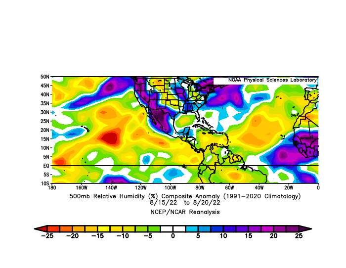
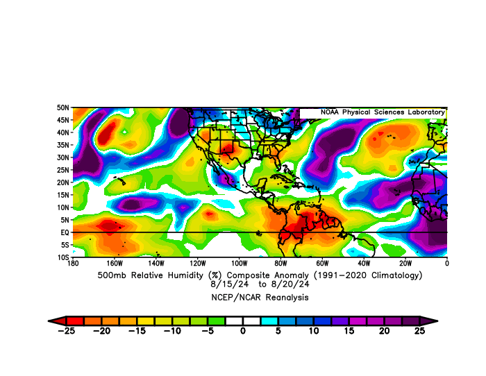
Since 2022 keeps coming up, let me drop this here... 500mb relative humidity anomalies during August 15-20 for 2022 and 2024.

Image
Image
0 likes   

User avatar
Hammy
Category 5
Category 5
Posts: 5849
Age: 41
Joined: Fri May 25, 2012 5:25 pm
Contact:

Re: 2024 Indicators: SST's, MSLP, Shear, SAL, Steering, Instability (Day 16+ Climate Models)

#2064 Postby Hammy » Fri Aug 23, 2024 3:37 am

ITCZ is north of 15 latitude in the western MDR, something I don't recall seeing since 2003--a week before we got Fabian

Image
Image


Teban54 wrote:Since 2022 keeps coming up, let me drop this here... 500mb relative humidity anomalies during August 15-20 for 2022 and 2024.

https://i.postimg.cc/nrDbYs9b/image.png
https://i.postimg.cc/RqxrPMw3/image.png


What were the shear anomalies for that time? I think that was another 2022 factor (at least as far as wave breaking/westerly shear) that's largely absent this year
3 likes   
The above post is not official and should not be used as such. It is the opinion of the poster and may or may not be backed by sound meteorological data. It is not endorsed by any professional institution or storm2k.org. For official information, please refer to the NHC and NWS products.

IsabelaWeather
Category 1
Category 1
Posts: 287
Age: 35
Joined: Tue Jul 07, 2020 7:29 am
Location: Isabela, Puerto Rico

Re: 2024 Indicators: SST's, MSLP, Shear, SAL, Steering, Instability (Day 16+ Climate Models)

#2065 Postby IsabelaWeather » Fri Aug 23, 2024 5:14 am

WiscoWx02 wrote:
IsabelaWeather wrote:
Category5Kaiju wrote:
Wisco, I'm not trying to be rude or mean here, but I personally think you have a very unrealistically bearish expectation for this season. For that to happen (as in, two or less storms in September), we really need to be in the 1910s or 1920s, when the Atlantic background state was quite unfavorable for major levels of activity. And we would have to basically disregard the extremely warm deep tropical waters, -ENSO state, and virtually every factor in place now that, historically speaking, point toward favoring Atlantic activity. It's not even September yet (we still have 9 days left to go, which is quite a bit of time in the world of tropical weather).


I've noticed this is a trait from that poster, bearish to the extreme. I have kept mental notes, posts bearish and when it busts it's like what has been said vanishes.

Maybe they are right about this season, but I seriously doubt it. Time will tell. I think 8 to 10 storms will form in september.


I am one of the bearish forecasts you will probably ever meet, and that goes for snowfall totals and severe weather back here at home. There is always a fly in the ointment. Sometimes I am horribly wrong yeah (2021 I said a lot of stuff that failed miserably but then other times I got it right but nothing I would dare get cocky over).


I must admit, being bearish is usually the most accurate take though. When I lived in Michigan I became overly bearish about snow accumulations and became a lot more accurate. :lol:

However, I am still trying to be optimistic about this season, I just dont see how it doesnt start producing quality systems soon. If not then I will gladly take my L and give you the W.
0 likes   

User avatar
Category5Kaiju
Category 5
Category 5
Posts: 4051
Joined: Thu Dec 24, 2020 12:45 pm
Location: Seattle

Re: 2024 Indicators: SST's, MSLP, Shear, SAL, Steering, Instability (Day 16+ Climate Models)

#2066 Postby Category5Kaiju » Fri Aug 23, 2024 6:46 am

Teban54 wrote:Since 2022 keeps coming up, let me drop this here... 500mb relative humidity anomalies during August 15-20 for 2022 and 2024.

https://i.postimg.cc/nrDbYs9b/image.png
https://i.postimg.cc/RqxrPMw3/image.png


Pretty clear that mid-level dry air was a significant problem in 2022. That definitely doesn't seem to be the case this year.
0 likes   
Unless explicitly stated, all info in my posts is based on my own opinions and observations. Tropical storms and hurricanes can be extremely dangerous. Do not think you can beat Mother Nature. Refer to an accredited weather research agency or meteorologist if you need to make serious decisions regarding an approaching storm.

LarryWx
Category 5
Category 5
Posts: 6246
Joined: Sun Sep 07, 2003 2:04 pm
Location: GA

Re: 2024 Indicators: SST's, MSLP, Shear, SAL, Steering, Instability (Day 16+ Climate Models)

#2067 Postby LarryWx » Fri Aug 23, 2024 8:18 am

Hammy wrote:ITCZ is north of 15 latitude in the western MDR, something I don't recall seeing since 2003--a week before we got Fabian

https://i.imgur.com/3cchUuw.png
https://i.imgur.com/K578kCN.png


Teban54 wrote:Since 2022 keeps coming up, let me drop this here... 500mb relative humidity anomalies during August 15-20 for 2022 and 2024.

https://i.postimg.cc/nrDbYs9b/image.png
https://i.postimg.cc/RqxrPMw3/image.png


What were the shear anomalies for that time? I think that was another 2022 factor (at least as far as wave breaking/westerly shear) that's largely absent this year


Doesn’t further N ITCZ increase coriolis force, which then makes it easier for a surface low to spin?

“During the late summer months, when the ITCZ is at its maximum north migration, it experiences a larger coriolis force (actually a conservation of momentum effect rather than a force). This physical situation is an essential component of cyclogenesis leading to tropical storms and hurricanes. It is the principal reason why the highest frequency and the greatest intensities for hurricanes occur during the months of August and September.”

https://pacificposse.com/itcz
0 likes   
Personal Forecast Disclaimer:
The posts in this forum are NOT official forecasts and should not be used as such. They are just the opinion of the poster and may or may not be backed by sound meteorological data. They are NOT endorsed by any professional institution or storm2k.org. For official information, please refer to the NHC and NWS products.

User avatar
Hypercane_Kyle
Category 5
Category 5
Posts: 3344
Joined: Sat Mar 07, 2015 7:58 pm
Location: Cape Canaveral, FL

Re: 2024 Indicators: SST's, MSLP, Shear, SAL, Steering, Instability (Day 16+ Climate Models)

#2068 Postby Hypercane_Kyle » Fri Aug 23, 2024 8:56 am

We do seem to be heading towards a less active, higher quality season than like, 2020/2021 for example. The lack of random spin up TC's is noticeable though considering the background state. The Atlantic just doesn't want anything spin this year.
1 likes   
My posts are my own personal opinion, defer to the National Hurricane Center (NHC) and other NOAA products for decision making during hurricane season.

User avatar
AnnularCane
S2K Supporter
S2K Supporter
Posts: 2836
Joined: Thu Jun 08, 2006 9:18 am
Location: Wytheville, VA

Re: 2024 Indicators: SST's, MSLP, Shear, SAL, Steering, Instability (Day 16+ Climate Models)

#2069 Postby AnnularCane » Fri Aug 23, 2024 9:26 am

Hypercane_Kyle wrote:We do seem to be heading towards a less active, higher quality season than like, 2020/2021 for example. The lack of random spin up TC's is noticeable though considering the background state. The Atlantic just doesn't want anything spin this year.


It spun up five times so far.
6 likes   
"But it never rained rain. It never snowed snow. And it never blew just wind. It rained things like soup and juice. It snowed mashed potatoes and green peas. And sometimes the wind blew in storms of hamburgers." -- Judi Barrett, Cloudy with a Chance of Meatballs

User avatar
toad strangler
S2K Supporter
S2K Supporter
Posts: 4543
Joined: Sun Jul 28, 2013 3:09 pm
Location: Earth
Contact:

Re: 2024 Indicators: SST's, MSLP, Shear, SAL, Steering, Instability (Day 16+ Climate Models)

#2070 Postby toad strangler » Fri Aug 23, 2024 9:29 am

LarryWx wrote: Doesn’t further N ITCZ increase coriolis force, which then makes it easier for a surface low to spin?

“During the late summer months, when the ITCZ is at its maximum north migration, it experiences a larger coriolis force (actually a conservation of momentum effect rather than a force). This physical situation is an essential component of cyclogenesis leading to tropical storms and hurricanes. It is the principal reason why the highest frequency and the greatest intensities for hurricanes occur during the months of August and September.”

https://pacificposse.com/itcz


Larry, Michael Lowry touched on this today in his latest update. See below ...

The wind shear conundrum
As we mentioned in Tuesday’s newsletter, wind shear has been high, especially in the eastern part of the Atlantic Main Development Region or MDR the past few weeks.
The higher-than-average wind shear is from winds tearing at would-be storms from the east, rather than from the west which is most typical during the hurricane season. The typical west-to-east upper-wind configuration that’s normally one of the biggest factors working against tropical development flipped so much in the other direction, it’s actually remained a deterrent. This is pretty unusual for the Atlantic.

One of the contributors to this unusual east-to-west wind shear in the eastern Atlantic has been a northward displacement of southwesterly (winds from the southwest) surface winds over parts of northern Africa known as the West African Monsoon or WAM. Typically, the northward displacement of the WAM would favor more robust disturbances, but it’s been so far north that it’s actually enhancing the easterly shear due to stronger winds from the west at the surface.

One of the causes of the WAM’s northward displacement is the so-called Atlantic Niña, a cooling of the waters around the equator in the eastern Atlantic just south of Africa.
5 likes   


User avatar
Hypercane_Kyle
Category 5
Category 5
Posts: 3344
Joined: Sat Mar 07, 2015 7:58 pm
Location: Cape Canaveral, FL

Re: 2024 Indicators: SST's, MSLP, Shear, SAL, Steering, Instability (Day 16+ Climate Models)

#2072 Postby Hypercane_Kyle » Fri Aug 23, 2024 10:18 am

AnnularCane wrote:
Hypercane_Kyle wrote:We do seem to be heading towards a less active, higher quality season than like, 2020/2021 for example. The lack of random spin up TC's is noticeable though considering the background state. The Atlantic just doesn't want anything spin this year.


It spun up five times so far.


And three of those were hurricanes and one a Cat 5, I know. Like I said, quality over quantity season. But I don't see how the predicts for 25+ named this year is possible if we only have two named storms in August. I do think we'll hit the hyperactive category for ACE though.
1 likes   
My posts are my own personal opinion, defer to the National Hurricane Center (NHC) and other NOAA products for decision making during hurricane season.

User avatar
REDHurricane
Category 1
Category 1
Posts: 394
Age: 27
Joined: Sun Jul 03, 2022 2:36 pm
Location: Northeast Pacific Ocean

Re: 2024 Indicators: SST's, MSLP, Shear, SAL, Steering, Instability (Day 16+ Climate Models)

#2073 Postby REDHurricane » Fri Aug 23, 2024 10:42 am

Hypercane_Kyle wrote:
AnnularCane wrote:
Hypercane_Kyle wrote:We do seem to be heading towards a less active, higher quality season than like, 2020/2021 for example. The lack of random spin up TC's is noticeable though considering the background state. The Atlantic just doesn't want anything spin this year.


It spun up five times so far.


And three of those were hurricanes and one a Cat 5, I know. Like I said, quality over quantity season. But I don't see how the predicts for 25+ named this year is possible if we only have two named storms in August. I do think we'll hit the hyperactive category for ACE though.


7 named storms in each of September/October/November gets it up to 26, that doesn't seem impossible or even extremely improbable at this point given the environmental conditions, and that's assuming there's nothing in the rest of August or into December
2 likes   

User avatar
Teban54
Category 5
Category 5
Posts: 3168
Joined: Sat May 19, 2018 1:19 pm

Re: 2024 Indicators: SST's, MSLP, Shear, SAL, Steering, Instability (Day 16+ Climate Models)

#2074 Postby Teban54 » Fri Aug 23, 2024 10:55 am

REDHurricane wrote:
Hypercane_Kyle wrote:
AnnularCane wrote:
It spun up five times so far.


And three of those were hurricanes and one a Cat 5, I know. Like I said, quality over quantity season. But I don't see how the predicts for 25+ named this year is possible if we only have two named storms in August. I do think we'll hit the hyperactive category for ACE though.


7 named storms in each of September/October/November gets it up to 26, that doesn't seem impossible or even extremely improbable at this point given the environmental conditions, and that's assuming there's nothing in the rest of August or into December

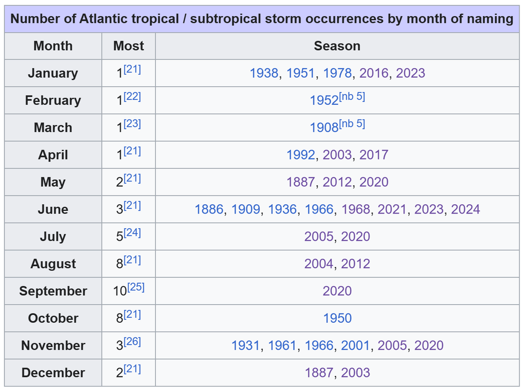
FYI, the record for number of storm formations in November is 3. Getting 7 storms in November is extremely unlikely.

Image

Source: Wikipedia. Note that before September 2020 broke the formation record with 10 storms, there were three seasons with 8 storms:

Image

In the most bullish scenario, record-tying formations for the next 3 months (10, 8, 3 storms each month) would get us to 26 storms. That should probably be seen as an absolute upper bound.
3 likes   

User avatar
aspen
Category 5
Category 5
Posts: 8812
Joined: Sat Oct 12, 2019 7:10 pm
Location: Connecticut, USA

Re: 2024 Indicators: SST's, MSLP, Shear, SAL, Steering, Instability (Day 16+ Climate Models)

#2075 Postby aspen » Fri Aug 23, 2024 11:00 am

REDHurricane wrote:
Hypercane_Kyle wrote:
AnnularCane wrote:
It spun up five times so far.


And three of those were hurricanes and one a Cat 5, I know. Like I said, quality over quantity season. But I don't see how the predicts for 25+ named this year is possible if we only have two named storms in August. I do think we'll hit the hyperactive category for ACE though.


7 named storms in each of September/October/November gets it up to 26, that doesn't seem impossible or even extremely improbable at this point given the environmental conditions, and that's assuming there's nothing in the rest of August or into December

7 each on October and November? That seems incredibly unlikely, especially since the max for November is 3 IIRC. We’d need a 2020-like late season to even get close.

With that said, I wouldn’t rule out a slightly enhanced late season due to the incoming La Niña and the northerly-displaced ITCZ; one reason why 2021 shut down after Sam was because of a quite far south ITCZ during October that resulted in most waves running into the northernmost parts of South America (similar to Bonnie the next year). We probably won’t have the same issue this October. Plus, there has been speculation about a late-shifted Cape Verde season this year.
0 likes   
Irene '11 Sandy '12 Hermine '16 5/15/2018 Derecho Fay '20 Isaias '20 Elsa '21 Henri '21 Ida '21

I am only a meteorology enthusiast who knows a decent amount about tropical cyclones. Look to the professional mets, the NHC, or your local weather office for the best information.

User avatar
Woofde
Category 1
Category 1
Posts: 475
Joined: Tue Jul 06, 2021 11:33 am

Re: 2024 Indicators: SST's, MSLP, Shear, SAL, Steering, Instability (Day 16+ Climate Models)

#2076 Postby Woofde » Fri Aug 23, 2024 11:08 am

REDHurricane wrote:
Hypercane_Kyle wrote:
AnnularCane wrote:
It spun up five times so far.


And three of those were hurricanes and one a Cat 5, I know. Like I said, quality over quantity season. But I don't see how the predicts for 25+ named this year is possible if we only have two named storms in August. I do think we'll hit the hyperactive category for ACE though.


7 named storms in each of September/October/November gets it up to 26, that doesn't seem impossible or even extremely improbable at this point given the environmental conditions, and that's assuming there's nothing in the rest of August or into December
7 named storms in November would be insanity. I don't think thats really possible. November can be very favorable (2020 is the prime example), but the area of favorability is mostly restricted to the Carribean. Things elsewhere tend to have cooled off too much to support storms. As an example, 2020 itself, a warmer than average Atlantic, only would support TCs in a small area.

There's a lot of difficulty getting to high NS counts. You need cooperation from both the Tropics and Subtropics. This year so far the Subtropics have been fast asleep. It's plenty warm up there, but unless we see a sign they're gonna wake up I doubt we break 20 NS. That said, I still think ACE will very easily clean hyperactive status.Image
1 likes   

User avatar
REDHurricane
Category 1
Category 1
Posts: 394
Age: 27
Joined: Sun Jul 03, 2022 2:36 pm
Location: Northeast Pacific Ocean

Re: 2024 Indicators: SST's, MSLP, Shear, SAL, Steering, Instability (Day 16+ Climate Models)

#2077 Postby REDHurricane » Fri Aug 23, 2024 11:23 am

Teban54 wrote:
REDHurricane wrote:
Hypercane_Kyle wrote:
And three of those were hurricanes and one a Cat 5, I know. Like I said, quality over quantity season. But I don't see how the predicts for 25+ named this year is possible if we only have two named storms in August. I do think we'll hit the hyperactive category for ACE though.


7 named storms in each of September/October/November gets it up to 26, that doesn't seem impossible or even extremely improbable at this point given the environmental conditions, and that's assuming there's nothing in the rest of August or into December

FYI, the record for number of storms in November is 3. Getting 7 storms in November is extremely unlikely.

https://i.postimg.cc/j5NTNsgF/image.png

Source: Wikipedia. Note that before September 2020 broke the formation record with 10 storms, there were three seasons with 8 storms:

https://i.postimg.cc/NFkwJdw8/image.png

In the most bullish scenario, record-tying formations for the next 3 months (10, 8, 3 storms each month) would get us to 26 storms. That should probably be seen as an absolute upper bound.


Lol fair enough, though I wouldn't be surprised if that record of 3 gets broken this year if the peak really is just delayed by a week or two due to the ICTZ/WAM being so far north as has been discussed. Peak starts 7-14 days later, peak ends 7-14 days later -- this might not be how it turns out obviously, but is there a reason to assume that the abnormally far north position of the ICTZ/WAM won't continue being abnormally far north through the next few months, thus ostensibly extending the hurricane season as tropical waves robust/north enough to potentially develop into named systems keep coming off into the Atlantic later than usual? I think that as the global climate becomes more and more extreme over the next several years/decades the blueprint of how a typical hurricane season progresses might not necessarily be as relevant anymore... everyone here has seen the numerous graphs/charts of all the SST and OHC records being demolished globally and particularly in the Atlantic basin this year, certainly that's going to have some very unpredictable effects on season-to-season hurricane activity imo and it doesn't seem like a huge stretch to say that TC activity could start extending later into November/December along with these unprecedented background conditions
1 likes   

User avatar
Teban54
Category 5
Category 5
Posts: 3168
Joined: Sat May 19, 2018 1:19 pm

Re: 2024 Indicators: SST's, MSLP, Shear, SAL, Steering, Instability (Day 16+ Climate Models)

#2078 Postby Teban54 » Fri Aug 23, 2024 11:31 am

REDHurricane wrote:
Teban54 wrote:
REDHurricane wrote:
7 named storms in each of September/October/November gets it up to 26, that doesn't seem impossible or even extremely improbable at this point given the environmental conditions, and that's assuming there's nothing in the rest of August or into December

FYI, the record for number of storms in November is 3. Getting 7 storms in November is extremely unlikely.

https://i.postimg.cc/j5NTNsgF/image.png

Source: Wikipedia. Note that before September 2020 broke the formation record with 10 storms, there were three seasons with 8 storms:

https://i.postimg.cc/NFkwJdw8/image.png

In the most bullish scenario, record-tying formations for the next 3 months (10, 8, 3 storms each month) would get us to 26 storms. That should probably be seen as an absolute upper bound.


Lol fair enough, though I wouldn't be surprised if that record of 3 gets broken this year if the peak really is just delayed by a week or two due to the WAM being so far north as has been discussed. Peak starts 7-14 days later, peak ends 7-14 days later -- this might not be how it turns out obviously, but is there a reason to assume that the abnormally far north position of the WAM won't continue being abnormally far north through the next few months, thus ostensibly extending the hurricane season as tropical waves robust/north enough to potentially develop into named systems keep coming off into the Atlantic later than usual? I think that as the global climate becomes more and more extreme over the next several years/decades the blueprint of how a typical hurricane season progresses might not necessarily be as relevant anymore... everyone here has seen the numerous graphs/charts of all the SST and OHC records being demolished globally and particularly in the Atlantic basin this year, certainly that's going to have some very unpredictable effects on season-to-season hurricane activity imo

Worth noting that 2020 also had an Atlantic Nina like this year, and its MDR season was actually somewhat delayed, even if it may not feel like it due to the constant NS spam. The bulk of the MDR geneses occurred during a very concentrated period between September 7 (Paulette, Rene) and September 17 (Wilfred). August 2020 did have two formations with MDR, but Josephine struggled all its life (typical of early August CV storms), and Laura formed near the western end of the open Atlantic while also not organizing much. In addition, there were also talks about waves exiting too far north that year, such as Rene.

2020 didn't have an extended CV season unlike 2023, but the Atlantic Nina helped send waves at just the right latitude into the Caribbean during late season, which fueled the insane October and November (Delta, Zeta, Eta, Iota). While the connection between that and Atlantic Nina is not technically proven yet, it's still quite ominous.

(I know some people may be thinking of 2021 as an example on the other extreme, and that waves may be too far south during October. However, I also recall analyses saying 2021's late season inactivity was due to other factors like a TUTT, so I don't think that's conclusive.)
0 likes   

tolakram
Admin
Admin
Posts: 19990
Age: 61
Joined: Sun Aug 27, 2006 8:23 pm
Location: Florence, KY (name is Mark)

Re: 2024 Indicators: SST's, MSLP, Shear, SAL, Steering, Instability (Day 16+ Climate Models)

#2079 Postby tolakram » Fri Aug 23, 2024 12:30 pm

The discussion here is good, so for those naming other users or suggestion it's not the time to talk about something, please stop. :)

I'd also challenge those saying some are too bearish to think (not actually identify) of those who are too bullish. If you can't then there might be some bias. :lol: Have fun with the discussion, the season will do it's think regardless of what we say or think, and then we can have a new discussion about that.
1 likes   
M a r k
- - - - -
Join us in chat: Storm2K Chatroom Invite. Android and IOS apps also available.

The posts in this forum are NOT official forecasts and should not be used as such. Posts are NOT endorsed by any professional institution or STORM2K.org. For official information and forecasts, please refer to NHC and NWS products.

Deshaunrob17
Tropical Storm
Tropical Storm
Posts: 207
Joined: Tue Aug 18, 2020 7:49 am

Re: 2024 Indicators: SST's, MSLP, Shear, SAL, Steering, Instability (Day 16+ Climate Models)

#2080 Postby Deshaunrob17 » Fri Aug 23, 2024 12:32 pm

Category5Kaiju wrote:
WiscoWx02 wrote:
MEANINGLESS_NUMBERS wrote:
I’ll take that bet. September will have some action, obviously, but I am skeptical that it will be terribly more than average.


I'm sure we will see a storm or two as well sure, but agreed, I wouldn't expect anything higher than slightly below average activity by end of the month


Wisco, I'm not trying to be rude or mean here, but I personally think you have a very unrealistically bearish expectation for this season. For that to happen (as in, two or less storms in September), we really need to be in the 1910s or 1920s, when the Atlantic background state was quite unfavorable for major levels of activity. And we would have to basically disregard the extremely warm deep tropical waters, -ENSO state, and virtually every factor in place now that, historically speaking, point toward favoring Atlantic activity. It's not even September yet (we still have 9 days left to go, which is quite a bit of time in the world of tropical weather).


While I would have expected much more this August, I think I can the same for majority of the Augusts in the last decade . August climatologically not the same as it was in 2004. We’ve seen dead Augusts turn into crazy busy Septembers. Atleast with this August we pulled off 2 hurricanes and almost 20 Ace.
I’m convinced September and would October would produce as we have seen many times in the past decade.
1 likes   


Return to “Talkin' Tropics”

Who is online

Users browsing this forum: No registered users and 210 guests