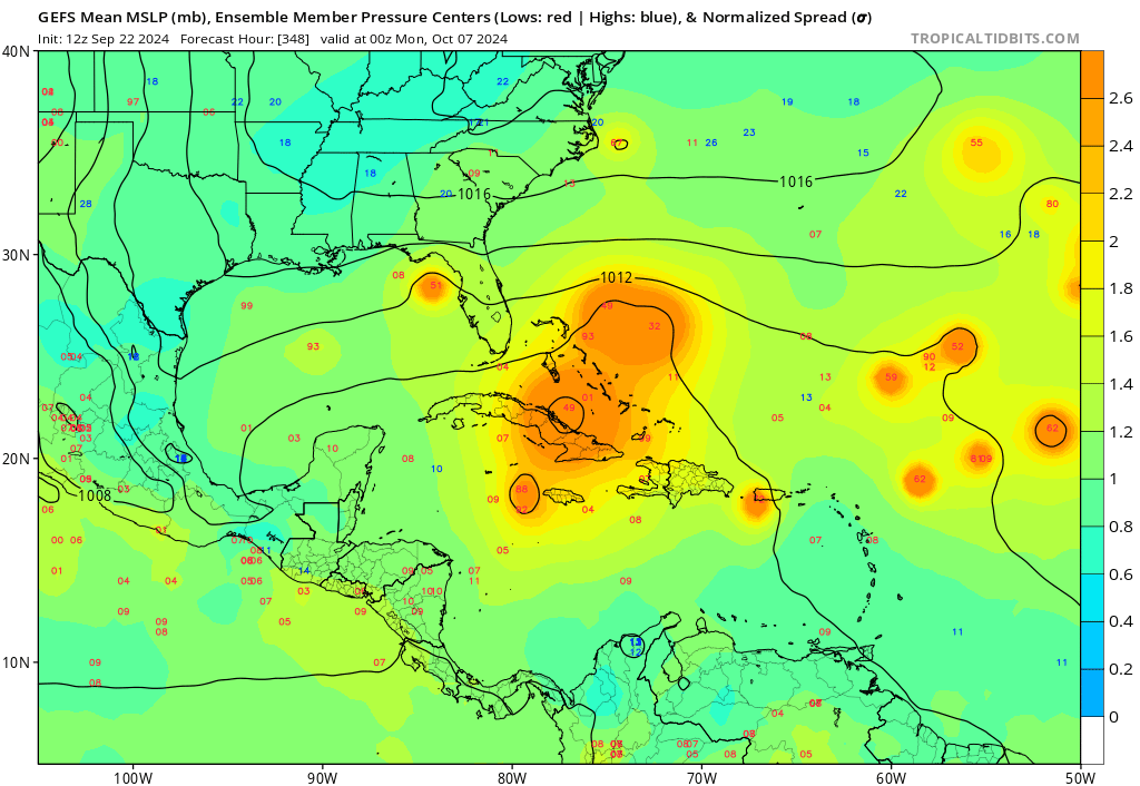
2024 Global Model Runs Discussion (Out thru day 16)

This is the general tropical discussion area. Anyone can take their shot at predicting a storms path.

Moderator: S2k Moderators

Forum rules

The posts in this forum are NOT official forecasts and should not be used as such. They are just the opinion of the poster and may or may not be backed by sound meteorological data. They are NOT endorsed by any professional institution or STORM2K. For official information, please refer to products from the National Hurricane Center and National Weather Service.

Help Support Storm2K
Message
Author
User avatar
Hammy
Category 5
Category 5
Posts: 5849
Age: 41
Joined: Fri May 25, 2012 5:25 pm
Contact:

Re: 2024 Global Model Runs Discussion (Out thru day 16)

#2081 Postby Hammy » Sun Sep 22, 2024 12:36 am

MetroMike wrote:
SconnieCane wrote:18Z GFS had another major hurricane forming in the Caribbean and striking the Florida Gulf Coast, behind the potential one we've all been watching for days. :eek: :double:


And again the 0z GFS has another perhaps MH right up the spine of Fl about 10 days after.
Crazy! I bet it will change though.


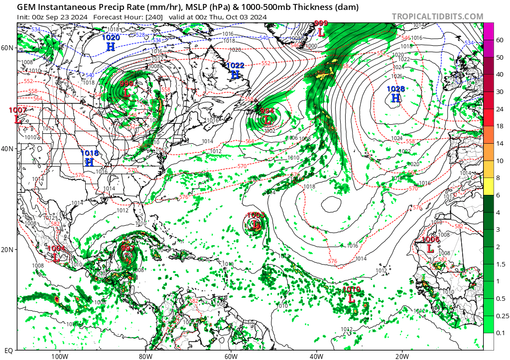
Canadian has a signal at 240 hours in the SW Caribbean same as it did with the current AOI, so there might be something to this. Maybe not GFS track/intensity, but certainly a real signal and not a model storm
2 likes   
The above post is not official and should not be used as such. It is the opinion of the poster and may or may not be backed by sound meteorological data. It is not endorsed by any professional institution or storm2k.org. For official information, please refer to the NHC and NWS products.

Powellrm
Tropical Storm
Tropical Storm
Posts: 102
Joined: Sun Sep 03, 2017 1:40 pm

Re: 2024 Global Model Runs Discussion (Out thru day 16)

#2082 Postby Powellrm » Sun Sep 22, 2024 10:06 am

The next day or so will be very critical moving forward. Will be closely monitoring. I meant to post this yesterday, but even when runs had this (potential) storm as a large and disorganized mess-I would not be surprised if it found a way to quickly organize somewhat and intensify more than expected. Not into anything high end, but more than expected. It seems like so often these systems surpass expectations and can maximize favorable ocean temps in spite of relative adversity. Despite certain conditions that would generally not be viewed as favorable for organization or intensifying.

It does appear to be a relatively fast mover which is at least a good thing. Does not seem to be a candidate to stall or lose steering upon landfall. But as of now, that is irrelevant as we don’t have anything concrete other than the data at hand. This could all be different by midday Monday.

Stay tuned and get prepped early.
2 likes   

User avatar
Category5Kaiju
Category 5
Category 5
Posts: 4097
Joined: Thu Dec 24, 2020 12:45 pm
Location: Seattle

Re: 2024 Global Model Runs Discussion (Out thru day 16)

#2083 Postby Category5Kaiju » Sun Sep 22, 2024 11:45 am

GFS seems interested in yet another Cape Verde system after the current MDR orange AOI.

Based on some previous ensemble runs (tbd for the 12z cycle), some members have this system going pretty far west and affecting the islands instead of cleanly recurving out to sea (as is the case for the current MDR AOI).
0 likes   
Unless explicitly stated, all info in my posts is based on my own opinions and observations. Tropical storms and hurricanes can be extremely dangerous. Do not think you can beat Mother Nature. Refer to an accredited weather research agency or meteorologist if you need to make serious decisions regarding an approaching storm.

User avatar
cajungal
Category 5
Category 5
Posts: 2330
Age: 49
Joined: Sun Mar 14, 2004 9:34 pm
Location: Schriever, Louisiana (60 miles southwest of New Orleans)

Re: 2024 Global Model Runs Discussion (Out thru day 16)

#2084 Postby cajungal » Sun Sep 22, 2024 12:10 pm

Is that system GFS was showing getting in gulf after this current system still showing up or did they drop it?
0 likes   

WeatherBoy2000
Category 1
Category 1
Posts: 346
Joined: Mon Apr 10, 2023 9:29 am

Re: 2024 Global Model Runs Discussion (Out thru day 16)

#2085 Postby WeatherBoy2000 » Sun Sep 22, 2024 12:16 pm

cajungal wrote:Is that system GFS was showing getting in gulf after this current system still showing up or did they drop it?


Yes but it shows it developing in the BOC instead.

With that said the GFS is nuts for late September into October showing 4-5 TC's developing including 3 hurricanes and 2 major hurricanes. Not saying any of this going happen but it all hints towards the Atlantic becoming more favorable than it has been recently.
2 likes   

User avatar
cajungal
Category 5
Category 5
Posts: 2330
Age: 49
Joined: Sun Mar 14, 2004 9:34 pm
Location: Schriever, Louisiana (60 miles southwest of New Orleans)

Re: 2024 Global Model Runs Discussion (Out thru day 16)

#2086 Postby cajungal » Sun Sep 22, 2024 12:37 pm

I was afraid of that
0 likes   

User avatar
SFLcane
S2K Supporter
S2K Supporter
Posts: 10163
Age: 47
Joined: Sat Jun 05, 2010 1:44 pm
Location: Lake Worth Florida

Re: 2024 Global Model Runs Discussion (Out thru day 16)

#2087 Postby SFLcane » Sun Sep 22, 2024 1:34 pm

This is some signal the GEFS is showing...

Image
2 likes   

User avatar
cajungal
Category 5
Category 5
Posts: 2330
Age: 49
Joined: Sun Mar 14, 2004 9:34 pm
Location: Schriever, Louisiana (60 miles southwest of New Orleans)

Re: 2024 Global Model Runs Discussion (Out thru day 16)

#2088 Postby cajungal » Sun Sep 22, 2024 1:43 pm

SFLcane wrote:This is some signal the GEFS is showing...

https://i.postimg.cc/nzThFFVB/vvvv.png


So yet another potential gulf storm?
0 likes   

otowntiger
Category 5
Category 5
Posts: 1921
Joined: Tue Aug 31, 2004 7:06 pm

Re: 2024 Global Model Runs Discussion (Out thru day 16)

#2089 Postby otowntiger » Sun Sep 22, 2024 4:27 pm

SFLcane wrote:This is some signal the GEFS is showing...

https://i.postimg.cc/nzThFFVB/vvvv.png

The big question is which way are those heading? For that time of year it would make sense if they were moving north or even northeast, right?
0 likes   

User avatar
Hammy
Category 5
Category 5
Posts: 5849
Age: 41
Joined: Fri May 25, 2012 5:25 pm
Contact:

Re: 2024 Global Model Runs Discussion (Out thru day 16)

#2090 Postby Hammy » Sun Sep 22, 2024 4:59 pm

Looks like all three main models now have the signal for another CAG event in the Caribbean in around 7-10 days
0 likes   
The above post is not official and should not be used as such. It is the opinion of the poster and may or may not be backed by sound meteorological data. It is not endorsed by any professional institution or storm2k.org. For official information, please refer to the NHC and NWS products.

User avatar
cycloneye
Admin
Admin
Posts: 145308
Age: 68
Joined: Thu Oct 10, 2002 10:54 am
Location: San Juan, Puerto Rico

Re: 2024 Global Model Runs Discussion (Out thru day 16)

#2091 Postby cycloneye » Sun Sep 22, 2024 6:10 pm

18Z GFS has a monster at long range. :eek:

Image
4 likes   
Visit the Caribbean-Central America Weather Thread where you can find at first post web cams,radars
and observations from Caribbean basin members Click Here

User avatar
cheezyWXguy
Category 5
Category 5
Posts: 6108
Joined: Mon Feb 13, 2006 12:29 am
Location: Dallas, TX

Re: 2024 Global Model Runs Discussion (Out thru day 16)

#2092 Postby cheezyWXguy » Sun Sep 22, 2024 6:11 pm

Sheesh, what is with the 18z gfs? First a Michael imitator, then a Maria imitator in the long range
2 likes   

User avatar
Teban54
Category 5
Category 5
Posts: 3204
Joined: Sat May 19, 2018 1:19 pm

Re: 2024 Global Model Runs Discussion (Out thru day 16)

#2093 Postby Teban54 » Sun Sep 22, 2024 6:19 pm

cheezyWXguy wrote:Sheesh, what is with the 18z gfs? First a Michael imitator, then a Maria imitator in the long range

The time of the year (early October) would perhaps make it even more reminiscent of the Great 1780 Hurricane than Maria. This model storm peaks at 923 mb just past the islands, and as a bonus, it also hits Bermuda while barely weakened at all :lol:

(Edit: Even better, the end of the run looks like it could still pull a Fiona.)

Also, if the 18z run plays out verbatim, Isaac must be seriously cursed. The name would be sandwiched between two highly destructive storms, yet somehow escape retirement despite being an I name.

Image
5 likes   

MarioProtVI
Category 4
Category 4
Posts: 935
Age: 24
Joined: Sun Sep 29, 2019 7:33 pm
Location: New Jersey

Re: 2024 Global Model Runs Discussion (Out thru day 16)

#2094 Postby MarioProtVI » Sun Sep 22, 2024 7:11 pm

The 12z and 18z GFS are probably the best ways 2024 would be able to bounce back strong - 18z alone probably nets about ~75-80 ACE combined from 97L, the 0/60 and the second wave models are starting to like that the GFS blows up into a Sam repeat. Were that to verify 2024 would be at about 135-140 ACE by around October 10, with still the rest of the month to go. It’s possible that low-end hyperactive status is back on the table, but only if everything lines up perfectly. 2022 almost had a shot but it was a bit lackluster in the end despite making a notable comeback.
5 likes   

User avatar
Category5Kaiju
Category 5
Category 5
Posts: 4097
Joined: Thu Dec 24, 2020 12:45 pm
Location: Seattle

Re: 2024 Global Model Runs Discussion (Out thru day 16)

#2095 Postby Category5Kaiju » Sun Sep 22, 2024 9:02 pm

Teban54 wrote:
cheezyWXguy wrote:Sheesh, what is with the 18z gfs? First a Michael imitator, then a Maria imitator in the long range

The time of the year (early October) would perhaps make it even more reminiscent of the Great 1780 Hurricane than Maria. This model storm peaks at 923 mb just past the islands, and as a bonus, it also hits Bermuda while barely weakened at all :lol:

(Edit: Even better, the end of the run looks like it could still pull a Fiona.)

Also, if the 18z run plays out verbatim, Isaac must be seriously cursed. The name would be sandwiched between two highly destructive storms, yet somehow escape retirement despite being an I name.

https://i.postimg.cc/KvrBTZZc/image.png


Would continue the season's theme of the female storms being the destructive storms....
0 likes   
Unless explicitly stated, all info in my posts is based on my own opinions and observations. Tropical storms and hurricanes can be extremely dangerous. Do not think you can beat Mother Nature. Refer to an accredited weather research agency or meteorologist if you need to make serious decisions regarding an approaching storm.

User avatar
Teban54
Category 5
Category 5
Posts: 3204
Joined: Sat May 19, 2018 1:19 pm

Re: 2024 Global Model Runs Discussion (Out thru day 16)

#2096 Postby Teban54 » Mon Sep 23, 2024 1:10 am

0z CMC now shows the second Caribbean storm in early October. I assume it's the same one that GFS has shown on and off recently.

Image
1 likes   

Hurricane Mike
Category 2
Category 2
Posts: 644
Joined: Tue Apr 10, 2018 7:44 am

Re: 2024 Global Model Runs Discussion (Out thru day 16)

#2097 Postby Hurricane Mike » Mon Sep 23, 2024 4:12 am

It does seem fascinating that the models are showing so much Cape Verde activity now, after the peak of the wave season.
0 likes   

User avatar
Hammy
Category 5
Category 5
Posts: 5849
Age: 41
Joined: Fri May 25, 2012 5:25 pm
Contact:

Re: 2024 Global Model Runs Discussion (Out thru day 16)

#2098 Postby Hammy » Mon Sep 23, 2024 5:06 am

GFS pushing back development of the first system by 24 hours on one run, not a good sign for development chances.
0 likes   
The above post is not official and should not be used as such. It is the opinion of the poster and may or may not be backed by sound meteorological data. It is not endorsed by any professional institution or storm2k.org. For official information, please refer to the NHC and NWS products.

User avatar
aspen
Category 5
Category 5
Posts: 8818
Joined: Sat Oct 12, 2019 7:10 pm
Location: Connecticut, USA

Re: 2024 Global Model Runs Discussion (Out thru day 16)

#2099 Postby aspen » Mon Sep 23, 2024 6:46 am

6z GFS ends with dual Cat 3s and another MDR TS. Not gonna happen, but after the models were so anemic for the majority of the season, it’s quite a change of pace to see the GFS continuously spitting out TCs run after run.
1 likes   
Irene '11 Sandy '12 Hermine '16 5/15/2018 Derecho Fay '20 Isaias '20 Elsa '21 Henri '21 Ida '21

I am only a meteorology enthusiast who knows a decent amount about tropical cyclones. Look to the professional mets, the NHC, or your local weather office for the best information.

User avatar
ElectricStorm
Category 5
Category 5
Posts: 5044
Age: 24
Joined: Tue Aug 13, 2019 11:23 pm
Location: Skiatook, OK / Norman, OK

Re: 2024 Global Model Runs Discussion (Out thru day 16)

#2100 Postby ElectricStorm » Mon Sep 23, 2024 1:14 pm

12z GFS drops all future development outside of the 20/70 becoming a short lived TS
1 likes   
B.S Meteorology, University of Oklahoma '25

Please refer to the NHC, NWS, or SPC for official information.


Return to “Talkin' Tropics”

Who is online

Users browsing this forum: abajan, duilaslol, riapal, TomballEd and 43 guests