
Long Range Models
Moderator: S2k Moderators
Forum rules

The posts in this forum are NOT official forecasts and should not be used as such. They are just the opinion of the poster and may or may not be backed by sound meteorological data. They are NOT endorsed by any professional institution or STORM2K. For official information, please refer to products from the National Hurricane Center and National Weather Service.
-
Eyewall
Re: Long Range Models
I think our potential storm will move more to the south than what modles are saying.
0 likes
-
Aric Dunn
- Category 5

- Posts: 21238
- Age: 43
- Joined: Sun Sep 19, 2004 9:58 pm
- Location: Ready for the Chase.
- Contact:
Interesting the 00z gfs is way farther south and west and hangs onto the system the whole time
http://www.nco.ncep.noaa.gov/pmb/nwprod ... loop.shtml
http://www.nco.ncep.noaa.gov/pmb/nwprod ... loop.shtml
0 likes
-
Aric Dunn
- Category 5
- Posts: 21238
- Age: 43
- Joined: Sun Sep 19, 2004 9:58 pm
- Location: Ready for the Chase.
- Contact:
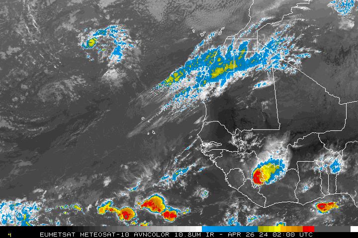
Re: Long Range Models
and i imagine the wave on right part of this image is the one the models are picking up on
0 likes


Re: Long Range Models
Very interesting 00z run, it looks more believeable, track is very similar to the more trusted sypnotic set up and tracking by the euro.
0 likes
-
Aric Dunn
- Category 5
- Posts: 21238
- Age: 43
- Joined: Sun Sep 19, 2004 9:58 pm
- Location: Ready for the Chase.
- Contact:
wow look at the ecmwf 12z .. that's interesting it was not there yesterday..
http://www.meteo.psu.edu/~gadomski/ECMW ... floop.html
http://www.meteo.psu.edu/~gadomski/ECMW ... floop.html
0 likes
Re: Long Range Models
Aric Dunn wrote:and i imagine the wave on right part of this image is the one the models are picking up on
Yeah it will emerge on Tuesday.
0 likes
-
Eyewall
Re: Long Range Models
Now that is what I am talking about but I think it will be more to the south than that. But if that were to happen what a nightmare track that would be for the florida keys and the Gulf coast would be under the gun next. That is a classic track for a cv hurricane one that we have not seen in years. 

0 likes
-
Eyewall
Re: Long Range Models
Not to mention just looking at the last image in motion that looks like a New Orleans landfall.They always say when a storm hits Miami for some reason louisiana is next. 
0 likes


Very intreresting models this morning, thats the most agressive ECM run I've seen yet, actually probably would be a tropical cyclone on that run. We will have to wair and see whether the models are right and wrong, got a powerful looking wave over Africa.
It is interesting and as we saw with Bertha in 1996 its certainly possible to get systems from the cape Verde regions at this time of year!
It is interesting and as we saw with Bertha in 1996 its certainly possible to get systems from the cape Verde regions at this time of year!
0 likes
-
Gustywind

- Category 5
- Posts: 12334
- Joined: Mon Sep 03, 2007 7:29 am
- Location: Baie-Mahault, GUADELOUPE
000
FXCA62 TJSJ 300856
AFDSJU
AREA FORECAST DISCUSSION
NATIONAL WEATHER SERVICE SAN JUAN PR
456 AM AST MON JUN 30 2008
THE NEXT SIGNIFICANT TROPICAL WAVE EXPECTED TO BRING AN INCREASE
IN WEATHER ACROSS THE ISLANDS IS CURRENTLY EXITING THE EAST COAST
OF AFRICA...AND IS EXPECTED TO REACH THE LOCAL AREA OVER THE
UPCOMING WEEKEND. THIS WAVE IS BEING FOLLOW BY A SECOND...WELL
ORGANIZED WAVE...THAT GFS BRINGS NEAR THE LEEWARD ISLANDS NEXT
MONDAY. OVERALL...PREVIOUS FORECAST REMAINS IN LINE WITH LATEST
MODEL GUIDANCE...SO ONLY A FEW MINOR TWEAKS MADE TO INHERITED
FORECAST PACKAGE THIS MORNING.
 " bear watching"? interresting paragrah just to mention it...let's see what happens during the 72 h , maybe ours next players,?...
FXCA62 TJSJ 300856
AFDSJU
AREA FORECAST DISCUSSION
NATIONAL WEATHER SERVICE SAN JUAN PR
456 AM AST MON JUN 30 2008
THE NEXT SIGNIFICANT TROPICAL WAVE EXPECTED TO BRING AN INCREASE
IN WEATHER ACROSS THE ISLANDS IS CURRENTLY EXITING THE EAST COAST
OF AFRICA...AND IS EXPECTED TO REACH THE LOCAL AREA OVER THE
UPCOMING WEEKEND. THIS WAVE IS BEING FOLLOW BY A SECOND...WELL
ORGANIZED WAVE...THAT GFS BRINGS NEAR THE LEEWARD ISLANDS NEXT
MONDAY. OVERALL...PREVIOUS FORECAST REMAINS IN LINE WITH LATEST
MODEL GUIDANCE...SO ONLY A FEW MINOR TWEAKS MADE TO INHERITED
FORECAST PACKAGE THIS MORNING.
0 likes
-
Eyewall
Re: Long Range Models
Head for the hills the atlantic is about to blow up these modles are showing stromes all over the place in early July 
0 likes
-
Extremeweatherguy

- Category 5
- Posts: 11095
- Joined: Mon Oct 10, 2005 8:13 pm
- Location: Florida
Re: Long Range Models
The 6z GFS now tracks this system west across the Atlantic and eventually into the east coast of Florida by July 12th...
http://www.nco.ncep.noaa.gov/pmb/nwprod ... loop.shtml
http://www.nco.ncep.noaa.gov/pmb/nwprod ... loop.shtml
0 likes
-
Ed Mahmoud
Re: Long Range Models
Extremeweatherguy wrote:The 6z GFS now tracks this system west across the Atlantic and eventually into the east coast of Florida by July 12th...
http://www.nco.ncep.noaa.gov/pmb/nwprod ... loop.shtml
6Z also has an "and then a miracle occured" development just past 5 days that affects Louisiana.
Looking at 850 mb vorticity fields, it goes "from zero to 60" in 12 hours on what looks to be a tropical depression or minimal tropical storm.
0 likes
Re: Long Range Models
Before any oil speculators read simeon9benjamin's posts and call their broker (oil is up to $143 this morning), I thought it best to post what is posted at the top of this page:
Forum rules
The posts in this forum are NOT official forecast and should not be used as such. They are just the opinion of the poster and may or may not be backed by sound meteorological data. They are NOT endorsed by any professional institution or storm2k.org. For official information, please refer to the NHC and NWS products.
0 likes
-
Ed Mahmoud
Re: Long Range Models
Ed Mahmoud wrote:Extremeweatherguy wrote:The 6z GFS now tracks this system west across the Atlantic and eventually into the east coast of Florida by July 12th...
http://www.nco.ncep.noaa.gov/pmb/nwprod ... loop.shtml
6Z also has an "and then a miracle occured" development just past 5 days that affects Louisiana.
Looking at 850 mb vorticity fields, it goes "from zero to 60" in 12 hours on what looks to be a tropical depression or minimal tropical storm.
Re: above post about oil speculators and unofficial forecasts. The part about "and then a miracle occured" should be taken as a hint this non-professional suspects some kind of convective feedback error and not a genuine development.
0 likes
Re: Long Range Models
Yes, Ed, I did think your comment was tongue in cheek, but, since the other posters "head for the hills" posts might be taken as fact, I thought it best to bring those pesty speculators back down to earth with some truth...
I agree with you that it all seems very suspect - nothing yesterday to everything today...
And, per the wave over Africa, yes, it is a significant wave, but, we've all seen 100 of those large waves dissipate as soon as they reach the cooler Atlantic - even yesterday's large wave that approached the coast of Africa (and had some here jumping up and down) has now largely dissipated, so...
0 likes
-
Meso

- Category 5
- Posts: 1609
- Age: 39
- Joined: Mon Aug 09, 2004 12:14 pm
- Location: South Africa
- Contact:
What, I fail to see what you are talking about often Frank2, Yesterday you said the SSTs in the Eastern Atlantic were below normal when all the data says otherwise, and now you seem completely against the idea of a storm forming.Sure it may not happen,but it if you shoot down every wave it's only a matter of time before you get it wrong.
The reasons for the people getting excited about yesterdays wave is because they thought it was this wave,the one which the models have been picking up on.
Yes we have seen good waves move off Africa and fizzle, but as the season goes on the conditions become more favourable.Currently the SSTs are 0.8-1.7`C above normal in that area.The SAL is not very strong and too the North unlike previous weeks.And now we have model agreements with every model.
Nothing yesterday? That was one run, if you've been following the models you would see that they have showed something more often than nothing, this includes the CMC,GFS and EURO.. the NOGAPS and UKMET were the outliers and the Ukmet is fairly conservative and the NOGAPS seems to be conservative with Eastern Atlantic systems in the past, or so it has seemed.
I'm not saying that something will develop,But I am saying that it is highly possible, whether it be just an invest,a TD, TS or Hurricane... No one has mentioned this becoming a CAT 5 or anything, only the fact that it appears a possible 'something' is near
0 likes
-
Ed Mahmoud
Re: Long Range Models
Well, in my uninformed and unprofessional opinion, since the majority of the models suggest some type of Cape Verde type development, and Bertha in 1996 showed early July development isn't impossible, something probably will develop. The UK Met weakens its system toward the end of its run, and most models show pretty strong high pressure North of the disturbance, so it could come all the way across. But it also has a long time/distance to cross where it could find an escape route.
And, while it probably develops, IMUAUP, even a majority of models predicting something doesn't guarantee it.
And, while it probably develops, IMUAUP, even a majority of models predicting something doesn't guarantee it.
0 likes
Who is online
Users browsing this forum: bird, cainjamin, Hurricanehink, Ulf and 157 guests