http://www.ssd.noaa.gov/goes/flt/t1/loop-vis.html
looks to me like we have rotation at some level...(in the last couple frames right off the coast..No?
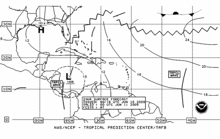
Area of disturbed weather in the Caribbean
Moderator: S2k Moderators
Forum rules

The posts in this forum are NOT official forecasts and should not be used as such. They are just the opinion of the poster and may or may not be backed by sound meteorological data. They are NOT endorsed by any professional institution or STORM2K. For official information, please refer to products from the National Hurricane Center and National Weather Service.
-
Ed Mahmoud
Re: Area of disturbed weather in the western Caribbean
cpdaman wrote:http://www.ssd.noaa.gov/goes/flt/t1/loop-vis.html
looks to me like we have rotation at some level...(in the last couple frames right off the coast..No?
The 20 to 40 knots of wind shear as depicted by CIMMS is also apparent on that visible imagery.
IIRC, about 3 or 4 days ago we were 4 or 5 days from a depression in the Caribbean per the GFS, and in my amateur and unofficial opinion, there won't be a depression anywhere in the Atlantic basin tomorrow...
0 likes

Re: Area of disturbed weather in the western Caribbean
cpdaman wrote:http://www.ssd.noaa.gov/goes/flt/t1/loop-vis.html
looks to me like we have rotation at some level...(in the last couple frames right off the coast..No?
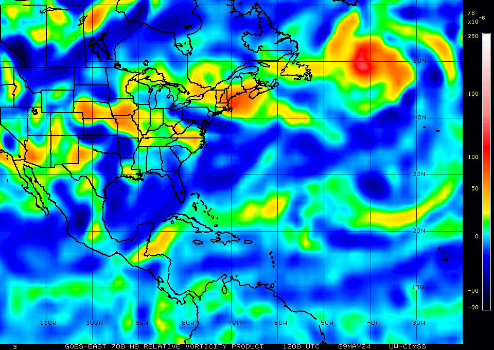
CMISS some some 700mb level and nothing at 850mb
http://cimss.ssec.wisc.edu/tropic2/real ... g8vor3.GIF
Ramsdis now has a floater over it.
http://hadar.cira.colostate.edu/ramsdis ... al/170.jpg
0 likes
-
Ed Mahmoud
Re: Area of disturbed weather in the western Caribbean
The GFS was the model that loved this before, but 12Z GFS keeps some low level twist and generally low pressure, but doesn't gin up anything tropical cyclone wise.
Now, on day 7, a frontal low dropping Southeast through the Mid-Atlantic, while still somewhat frontal in nature, has nearly circular isobars around it by hour 180 off the South Carolina coast, but that would be for the long range model thread and it isn't worth its own post yet.
Puerto Cabezas has an East wind, and looking at the satellite, that is 180º off of what it should be if there was anything resembling a closed low.
0 likes
-
cycloneye

- Admin

- Posts: 148738
- Age: 69
- Joined: Thu Oct 10, 2002 10:54 am
- Location: San Juan, Puerto Rico
Re: Area of disturbed weather in the western Caribbean
HPC latest discussion of Caribbean area
TROPICAL DISCUSSION - INTERNATIONAL DESKS
NWS HYDROMETEOROLOGICAL PREDICTION CENTER CAMP SPRINGS MD
214 PM EDT TUE JUN 09 2009
PATTERN EVOLUTION-FORECAST IS MORE COMPLICATED OVER THE CENTRAL
AND SOUTHERN CARIBBEAN. IN THIS AREA THE MODELS DISAGREE ON RISK
OF CYCLOGENESIS ALONG THE INDUCED/INVERTED TROUGH. LATEST
SATELLITE IMAGES SHOWS A SMALL CYCLONE OFF THE NORTHEAST COAST OF
HONDURAS. UNDER INFLUENCE OF THE UPPER TROUGH...AND IN INTERACTION
WITH A TROPICAL WAVE OVER THE CENTRAL CARIBBEAN...THE GFS
FORECASTS THIS SYSTEM TO RETAIN ITS INTEGRITY WHILE LIFTING TO THE
NORTHEAST TOWARDS JAMAICA THROUGH 36-42 HRS. THE GFS THEN
FORECASTS THE CYCLONE TO STALL. THE NAM INITIALLY FOLLOWS A
SIMILAR EVOLUTION...THEN FORECASTS THE LOW TO MIGRATE WEST TO
SOUTH OF THE CAYMAN ISLANDS BY 78 HRS. THE ECMWF FAILS TO
INITIALIZE THE LOW...AND TRIES TO DEVELOP A CLOSED CIRCULATION
OVER THE SOUTHERN CARIBBEAN BY 54-60 HRS. THIS SYSTEM IS IN A HIGH
SHEAR ENVIRONMENT...SO IT IS SOMEWHAT QUESTIONABLE THAT IT MIGHT
SURVIVE/INTENSIFY AT THE PACE THE GFS/NAM INDICATE. CONDITIONS
MIGHT BE MORE FAVORABLE AFTER 48/60 HRS WHEN THE UPPER LOW CUTS
OFF AND THE INFLOW OF COLD AIR ALOFT STARTS TO WANE.
MEANWHILE...THE SURFACE CYCLONE WILL FAVOR ORGANIZED DEEP
CONVECTION OVER NORTHEAST HONDURAS WHERE WE EXPECT RAINFALL
AMOUNTS OF 10-15MM/DAY AND MAXIMA OF 30-60MM. MOST INTENSE IS
EXPECTED OVER WATER...AND AS THE WEAK VORTEX MIGRATES TOWARDS
JAMAICA THROUGH 36 HRS IT WILL FAVOR A SURGE IN ACTIVITY. AS A
RESULT...BETWEEN 24-60 HRS...WE EXPECT ACCUMULATION OF 20-40MM/DAY
AND MAXIMA OF 150-250MM TO AFFECT JAMAICA... HAITIAN PENINSULA AND
PORTIONS OF EASTERN CUBA. CONVECTION MIGHT PERSIST INTO DAY
03...BUT THIS WILL BE HIGHLY DEPENDENT ON INTENSITY/INTEGRITY OF
THE SURFACE CYCLONE. WE ARE GOING FOR HEAVY RAINS ON DAY 03...AS A
WORST CASE SCENARIO...BUT THIS IS A LOW CONFIDENCE FORECAST. THE
MAXIMA WILL PERSIST AT 150-250MM...WITH POSSIBILITY OF EXPANDING
TOWARDS THE CAYMAN ISLANDS.
http://www.hpc.ncep.noaa.gov/discussions/fxca20.html
0 likes
Re: Area of disturbed weather in the western Caribbean
9z model runs starting to show a low comin out of the Southern Caribbean moving North or northwest. They all keep it fairly weak.
CMC shows nothing.
Pretty good view of area of concern, I think i see a broad area of weak turning already @11N/77W in a high shear enviroment.
http://hadar.cira.colostate.edu/ramsdis ... al/172.jpg
CMC shows nothing.
Pretty good view of area of concern, I think i see a broad area of weak turning already @11N/77W in a high shear enviroment.
http://hadar.cira.colostate.edu/ramsdis ... al/172.jpg
0 likes


-
floridasun78
- Category 5

- Posts: 3755
- Joined: Sun May 17, 2009 10:16 pm
- Location: miami fl
-
cycloneye
- Admin
- Posts: 148738
- Age: 69
- Joined: Thu Oct 10, 2002 10:54 am
- Location: San Juan, Puerto Rico
Re:
floridasun78 wrote:ok why model pick this up because their not thing in carribbean shear very high????
Shear will diminush in the next few days if the CMC data is right.
http://moe.met.fsu.edu/cgi-bin/cmctc2.c ... =Animation
0 likes
-
srainhoutx

- S2K Supporter

- Posts: 6919
- Age: 68
- Joined: Sun Jan 14, 2007 11:34 am
- Location: Haywood County, NC
- Contact:
Re: Area of disturbed weather in the western Caribbean
I noticed that model guidance suggests that a Tropical Wave may enter the picture next week. The ECMWF seems to build a dome of high pressure further south in the GOM that would force any tropical activity west into the Yucatan, while the GFS allows the wave to move a bit further north into the central GOM. We shall see.
0 likes

Re: Area of disturbed weather in the western Caribbean
[quote="srainhoutx"]I noticed that model guidance suggests that a Tropical Wave may enter the picture next week. The ECMWF seems to build a dome of high pressure further south in the GOM that would force any tropical activity west into the Yucatan, while the GFS allows the wave to move a bit further north into the central GOM. We shall see.[/quote]
Apparently the NWS in Mobile tends to favor the ECMWF:
000
FXUS64 KMOB 100955
AFDMOB
AREA FORECAST DISCUSSION
NATIONAL WEATHER SERVICE MOBILE AL
455 AM CDT WED JUN 10 2009
TO THE SOUTH...A WEAK SHEAR AXIS REMAINS DRAPED OVER THE WESTERN CARIBBEAN. THE
10.00 GLOBAL SPECTRAL MODELS OF THE GFS AND ECMWF DEVELOP A CLOSED
LOW IN A FEW DAYS OVER THIS AREA. MEANWHILE...THE CANADIAN RUN
SUGGESTS A MID LEVEL LOW WITH LITTLE SURFACE DEVELOPMENT. THE GFS IS
FASTER AND MORE NORTH TAKING LOW NORTHWEST INTO THE SOUTHEAST GULF
THEN CURVING IT LEFT EARLY NEXT WEEK AS IT INTERACTS WITH A STRONG
MID LEVEL RIDGE DEVELOPING EASTWARD OVER THE DEEP SOUTH. THE ECMWF
TAKES ITS SLOWER MOVING LOW NORTHWEST INTO THE YUCATAN PENINSULA BY
TUESDAY. REGARDLESS...IT APPEARS WE WILL HAVE ENOUGH RIDGING ALOFT TO
ACT AS A SHIELD...PREVENTING ANYTHING DOWN THERE FROM GAINING MUCH
LATITUDE. /10
&&
0 likes

Re: Area of disturbed weather in the western Caribbean
Dry air. By satellite look there's nothing happening unless that EPAC disturbance by Panama crosses over:

0 likes
-
Ed Mahmoud
Re: Area of disturbed weather in the western Caribbean
I wouldn't mind a weak depression or storm here in Texas next week, it has been dry as a bone, and awfully warm, but I'm not expecting it.
I don't wish a tropical storm on anyone really, unless they are having a drought, but a storm into Tamaulipas would probably turn low and mid level winds to a more Easterly, than Southerly direction, and push back the cap of forged steel over Southeast Texas, and at least allow sea breeze induced storms, or outer convergence band showers. Padre Island's hurricane last year was one of the few rainy episodes we had in Houston last Summer.
GFS looks like it sort of tries to get something going, gets it to the Bahamas, and then quickly merges it into a frontal system. I can't tell if ingesting the weak Bahamas system is why the GFS strengthens its Nor'Easter looking frontal low over New England next Tuesday or not.
0 likes
-
cycloneye
- Admin
- Posts: 148738
- Age: 69
- Joined: Thu Oct 10, 2002 10:54 am
- Location: San Juan, Puerto Rico
Re: Area of disturbed weather in the western Caribbean
12z CMC turns bullish

Animation of the 12z CMC run
http://moe.met.fsu.edu/cgi-bin/cmctc2.c ... =Animation
Animation of the 12z CMC run
http://moe.met.fsu.edu/cgi-bin/cmctc2.c ... =Animation
0 likes
-
Ed Mahmoud
Re: Area of disturbed weather in the western Caribbean
Looking at the PSU 4 panel of the Canadian, it makes this quite the little system despite being in a fairly dry environment, at least at the 700-500 mb level.

The base US Canadian four panel shows somewhat better 700 mb relative humidities, implying the drier air is mainly above 700 mb, but still.

A weaker version of the Canadian would be a happy thing for my lawn, but the GFS, which had been riding the tropical cyclone happy train for at least a week, and implied we'd already have a cyclone by now a few days ago, seems to have backed way off.
The base US Canadian four panel shows somewhat better 700 mb relative humidities, implying the drier air is mainly above 700 mb, but still.
A weaker version of the Canadian would be a happy thing for my lawn, but the GFS, which had been riding the tropical cyclone happy train for at least a week, and implied we'd already have a cyclone by now a few days ago, seems to have backed way off.
0 likes

Who is online
Users browsing this forum: No registered users and 73 guests