2012 WPAC season
Moderator: S2k Moderators
Forum rules

The posts in this forum are NOT official forecasts and should not be used as such. They are just the opinion of the poster and may or may not be backed by sound meteorological data. They are NOT endorsed by any professional institution or STORM2K. For official information, please refer to products from the National Hurricane Center and National Weather Service.
-
dexterlabio
- Category 5

- Posts: 3499
- Joined: Sat Oct 24, 2009 11:50 pm
Re: 2012 WPAC season
the action begins in the WPAC. :>
0 likes
Personal Forecast Disclaimer:
The posts in this forum are NOT official forecast and should not be used as such. They are just the opinion of the poster and may or may not be backed by sound meteorological data. They are NOT endorsed by any professional institution or storm2k.org. For official information, please refer to the NHC and NWS products.
The posts in this forum are NOT official forecast and should not be used as such. They are just the opinion of the poster and may or may not be backed by sound meteorological data. They are NOT endorsed by any professional institution or storm2k.org. For official information, please refer to the NHC and NWS products.
-
somethingfunny

- ChatStaff

- Posts: 3926
- Age: 37
- Joined: Thu May 31, 2007 10:30 pm
- Location: McKinney, Texas
Re: 2012 WPAC season
First time in a week that I've seen anything other than a blank discussion from JTWC:
ABPW10 PGTW 100600
MSGID/GENADMIN/JOINT TYPHOON WRNCEN PEARL HARBOR HI//
SUBJ/SIGNIFICANT TROPICAL WEATHER ADVISORY FOR THE WESTERN AND
/SOUTH PACIFIC OCEANS/100600Z-110600ZSEP2012//
RMKS/
1. WESTERN NORTH PACIFIC AREA (180 TO MALAY PENINSULA):
A. TROPICAL CYCLONE SUMMARY: NONE.
B. TROPICAL DISTURBANCE SUMMARY:
(1) THE AREA OF CONVECTION PREVIOUSLY LOCATED NEAR 7.0N
137.0E, IS NOW LOCATED NEAR 7.7N 136.3E, APPROXIMATELY 100 NM EAST-
NORTHEAST OF PALAU. ANIMATED MULTISPECTRAL IMAGERY DEPICTS A LARGE
AREA OF DISORGANIZED YET PERSISTENT DEEP CONVECTION WHICH IS OVER
THE WESTERN SEMI CIRCLE OF A LOW-LEVEL CIRCULATION (LLCC). A
100110Z PARTIAL ASCAT PASS DEPICTS 05-10 KNOT WINDS ON THE WESTERN
EDGE OF THE LLCC AND VERY DISORGANIZED WINDS OVER THE REMAINDER OF
THE WESTERN SEMI CIRCLE. OBSERVATIONS FROM PALAU AND YAP HAVE
REMAINED NEAR 1007 MB AND WINDS HAVE BECOME VARIABLE AND WEAKER
AROUND 05-10 KNOTS. UPPER-LEVEL ANALYSIS INDICATES A POINT SOURCE
OF DIFFLUENCE OVER THE AREA WITH MODERATE (10-15 KNOTS) OF VERTICAL
WIND SHEAR ACTING ON THE SYSTEM. SEA SURFACE TEMPERATURES IN THE
AREA ARE FAVORABLE (29-30 DEGREES CELSIUS) FOR DEVELOPMENT. MAXIMUM
SUSTAINED SURFACE WINDS ARE ESTIMATED AT 12 TO 18 KNOTS. MINIMUM
SEA LEVEL PRESSURE IS ESTIMATED TO BE NEAR 1006 MB. DUE TO THE LACK
OF CONSOLIDATION BUT A FAVORABLE UPPER-LEVEL ENVIRONMENT, THE
POTENTIAL FOR THE DEVELOPMENT OF A SIGNIFICANT TROPICAL CYCLONE
WITHIN THE NEXT 24 HOURS REMAINS MEDIUM.
(2) THE AREA OF CONVECTION HAS PERSISTED NEAR 30.6N
148.3E, APPROXIMATELY 530 NM EAST-SOUTHEAST OF TOKYO, JAPAN.
ANIMATED MULTISPECTRAL SATELLITE IMAGERY DEPICTS A PARTIALLY-
EXPOSED LOW LEVEL CIRCULATION CENTER (LLCC) WITH PERSISTENT DEEP
CONVECTION OVER THE SOUTH QUADRANT. A 092323Z METOP-A IMAGE SHOWS A
DEFINED LLCC WITH WEAK CONVECTIVE BANDING OVER THE SOUTHWEST
QUADRANT WRAPPING INTO THE SOUTHEAST QUADRANT. A 092322Z ASCAT
IMAGE INDICATES A SMALL, DEVELOPING LLCC WITH 15-20 KNOT WINDS AND
ISOLATED 20-25 KNOT WINDS DISPLACED NORTH OF THE CENTER; THESE
STRONGER WINDS HAVE NOT YET WRAPPED INTO THE LLCC. UPPER-LEVEL
ANALYSIS INDICATES THAT THE LLCC IS LOCATED ALONG THE NORTHERN EDGE
OF A BROAD UPPER-LEVEL LOW AND IS UNDER MODERATE (10-20 KNOTS)
NORTHEASTERLY VERTICAL WIND SHEAR, WHICH IS HINDERING CONVECTIVE
ORGANIZATION. ADDITIONALLY, THERE IS ANOTHER WEAK, BROAD, EXPOSED
CIRCULATION EVIDENT TO THE SOUTHWEST AT 26.6N 144.8E. BASED ON THE
DEFINED CIRCULATION EVIDENT ON THE RECENT ASCAT IMAGE, MAXIMUM
SUSTAINED SURFACE WINDS ARE ESTIMATED AT 12 TO 18 KNOTS. MINIMUM
SEA LEVEL PRESSURE IS ESTIMATED TO BE NEAR 1006 MB. SEA SURFACE
TEMPERATURES IN THE AREA ARE FAVORABLE (27-29 DEGREES CELSIUS) FOR
DEVELOPMENT OF A TROPICAL CYCLONE. THE POTENTIAL FOR THE
DEVELOPMENT OF A SIGNIFICANT TROPICAL CYCLONE WITHIN THE NEXT 24
HOURS REMAINS MEDIUM.
(3) NO OTHER SUSPECT AREAS.
2. SOUTH PACIFIC AREA (WEST COAST OF SOUTH AMERICA TO 135 EAST):
A. TROPICAL CYCLONE SUMMARY: NONE.
B. TROPICAL DISTURBANCE SUMMARY: NONE.//
NNNN
0 likes
I am not a meteorologist, and any posts made by me are not official forecasts or to be interpreted as being intelligent. These posts are just my opinions and are probably silly opinions.
-
hurricanes1234
- Category 5
- Posts: 2908
- Joined: Sat Jul 28, 2012 6:19 pm
- Location: Trinidad and Tobago
Re: 2012 WPAC season
Well, we have Super Typhoon Sanba, which is a 900 mbar Category 5 storm!
0 likes
PLEASE NOTE: With the exception of information from weather agencies that I may copy and paste here, my posts will NEVER be official, since I am NOT a meteorologist. They are solely my amateur opinion, and may or may not be accurate. Therefore, please DO NOT use them as official details, particularly when making important decisions. Thank you.
-
euro6208
Re: 2012 WPAC season
hurricanes1234 wrote:Well, we have Super Typhoon Sanba, which is a 900 mbar Category 5 storm!
that's just an estimate from JMA as they round off to the nearest 5...
the real pressure is likely between 890-870 mb when compared with many other similiar typhoons at this intensity which had recon...
0 likes
-
euro6208
Re: 2012 WPAC season
Current Year to date
160.57
we are slightly ahead of the 1981-2010 climatology of 160...thanks to sanba who explosively intensified and is now a monster 150 knot STY...
160.57
we are slightly ahead of the 1981-2010 climatology of 160...thanks to sanba who explosively intensified and is now a monster 150 knot STY...
0 likes


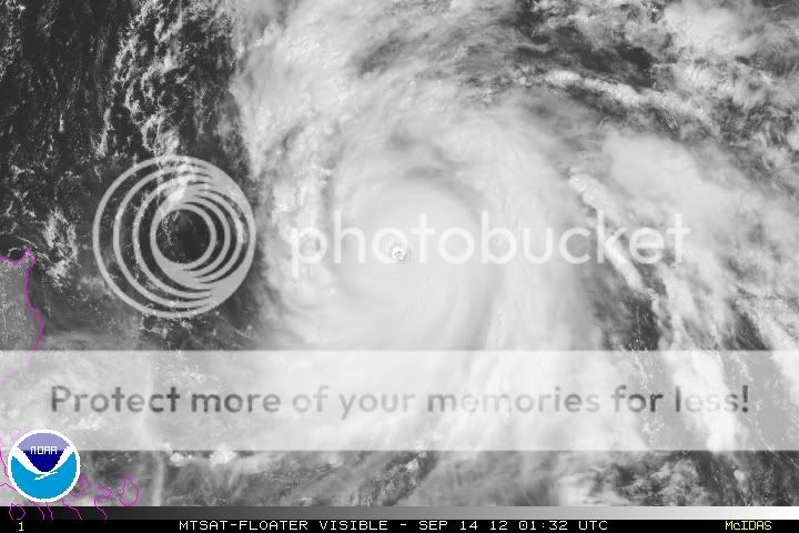
Re: 2012 WPAC season
A visible shot of Sanba (Karen) roaring up the WPAC:
0 likes
NOTICE: I cannot give an expert analysis. Most of my "observations" are made visually with the help of only vital information provided by public advisories.
-
euro6208
Re: 2012 WPAC season

long range euro shows another tropical cyclone developing in the philippine sea....
0 likes
-
euro6208


-
dexterlabio
- Category 5
- Posts: 3499
- Joined: Sat Oct 24, 2009 11:50 pm
Re: 2012 WPAC season
The lates Euro now developing 2 TC's at long range. It also shows that other system crossing Luzon then develops further in SCS. Not that it should be expected exactly as it's shown because there lacks a consistency in the forecast track...but there is actually a consistency about some TC formation during the last week of September..so something people have to keep an eye on.
0 likes
Personal Forecast Disclaimer:
The posts in this forum are NOT official forecast and should not be used as such. They are just the opinion of the poster and may or may not be backed by sound meteorological data. They are NOT endorsed by any professional institution or storm2k.org. For official information, please refer to the NHC and NWS products.
The posts in this forum are NOT official forecast and should not be used as such. They are just the opinion of the poster and may or may not be backed by sound meteorological data. They are NOT endorsed by any professional institution or storm2k.org. For official information, please refer to the NHC and NWS products.
-
euro6208
Re: 2012 WPAC season

The enhanced convective phase of the MJO is forecast to be over the western Pacific (phase 6) during Week-1.
The enhanced phase of the MJO is forecast to move across the western Pacific (phase 7) during Week-2.
an active period ahead with above average rainfall...
0 likes
-
euro6208
Re: 2012 WPAC season
[img] [/img]

double whammy for japan as euro develops another storm near guam and takes it to japan and right behind, jelawat hits the same area...

long range euro showing two tropical cyclones, one in the south china sea and the other right over guam...
[/img]double whammy for japan as euro develops another storm near guam and takes it to japan and right behind, jelawat hits the same area...
long range euro showing two tropical cyclones, one in the south china sea and the other right over guam...
0 likes
-
dexterlabio
- Category 5
- Posts: 3499
- Joined: Sat Oct 24, 2009 11:50 pm
Re: 2012 WPAC season
Euro 'flip-flopped' again with a northwest solution. 
0 likes
Personal Forecast Disclaimer:
The posts in this forum are NOT official forecast and should not be used as such. They are just the opinion of the poster and may or may not be backed by sound meteorological data. They are NOT endorsed by any professional institution or storm2k.org. For official information, please refer to the NHC and NWS products.
The posts in this forum are NOT official forecast and should not be used as such. They are just the opinion of the poster and may or may not be backed by sound meteorological data. They are NOT endorsed by any professional institution or storm2k.org. For official information, please refer to the NHC and NWS products.
-
euro6208
Re: 2012 WPAC season
dexterlabio wrote:Euro 'flip-flopped' again with a northwest solution.
lol...no longer showing this heading to japan but instead to the philippines as a powerful typhoon...then it's hong kong all over again...
our next tropical cyclone is likely developing west of guam...
0 likes
-
euro6208
Re: 2012 WPAC season
Besides Jelawat and soon *Ewiniar*, euro consistently showing another tropical cyclone developing east of guam and tracking over the cnmi...it develops further while moving west through the philippine sea...
looks like the storm formation areas are shifting to the east due to a developing el nino which will put guam at a higher risk...
looks like the storm formation areas are shifting to the east due to a developing el nino which will put guam at a higher risk...
0 likes

-
euro6208
Re: 2012 WPAC season
http://www.guampdn.com/article/20120911/NEWS01/120911002/UPDATE-New-Navy-drones-will-deploy-Guam
A newer, larger surveillance drone — specifically designed to watch the world’s oceans — will be based in Guam over the next few years, adding another layer to the cutting-edge technology at Andersen Air Force Base.
Very interesting...we desperately need this! the western pacific is home to the strongest cyclones worldwide and each year, many develop...this will certainly help us understand each one of them...i really wish it was this year
i didn't know we have global hawks already! we could surely use them!
0 likes
-
cycloneye

- Admin

- Posts: 148488
- Age: 69
- Joined: Thu Oct 10, 2002 10:54 am
- Location: San Juan, Puerto Rico
Re: 2012 WPAC season
It looks like more action is instored on the WPAC for the next two weeks.

0 likes
Visit the Caribbean-Central America Weather Thread where you can find at first post web cams,radars
and observations from Caribbean basin members Click Here
and observations from Caribbean basin members Click Here
-
Kingarabian

- S2K Supporter

- Posts: 16275
- Joined: Sat Aug 08, 2009 3:06 am
- Location: Honolulu, Hawaii
-
Typhoon Hunter
- WesternPacificWeather.com

- Posts: 1222
- Joined: Wed Oct 11, 2006 11:37 am
- Location: Tokyo
- Contact:
Re: 2012 WPAC season
GFS especially showing a prolonged period of TC activity out here and mild El Nino would suggest activity well into December. Currently bang on average in terms of 18 named storms (18.3 average to date,) ACE 198 (average year to date 188.) So really what we're seeing right now is Wpac business as usual. I wouldn't be surprised to see above average activity throughout the rest of the year.
Just my 2 cents!
Just my 2 cents!
0 likes
-
dexterlabio
- Category 5
- Posts: 3499
- Joined: Sat Oct 24, 2009 11:50 pm
Re: 2012 WPAC season
Interesting to note that out of the many tropical cyclones exceeding TS strength so far, majority of them attained typhoon status (11 out of 18...13 if you include Pakhar and Sanvu which were typhoons based on 1-min average). We've had 7 major typhoons, 3 super typhoons and 2 Cat5 typhoons. Let's see if this will be maintained as we enter the last quarter of this year.
0 likes
Personal Forecast Disclaimer:
The posts in this forum are NOT official forecast and should not be used as such. They are just the opinion of the poster and may or may not be backed by sound meteorological data. They are NOT endorsed by any professional institution or storm2k.org. For official information, please refer to the NHC and NWS products.
The posts in this forum are NOT official forecast and should not be used as such. They are just the opinion of the poster and may or may not be backed by sound meteorological data. They are NOT endorsed by any professional institution or storm2k.org. For official information, please refer to the NHC and NWS products.
Who is online
Users browsing this forum: No registered users and 65 guests