Yellow Evan wrote:Shell Mound wrote:mixedDanilo.E wrote:We are very much in a +AMO. Bs to think we aren’t. A -AMO wouldn’t produce the type of landfalls we been seeing every year since 2016.
There have been plenty of strong landfalls during -AMOs (i.e., 1970’s Celia, 1975’s Eloise, and so on). Arguably -AMOs tend to produce more high-end impacts, at least under some circumstances, because they favour homegrown genesis and/or nearshore RI (i.e., 1992’s Andrew and 2018’s Michael).
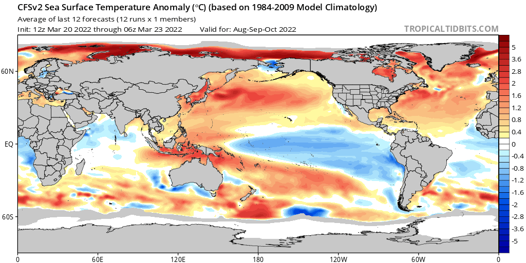
I still think that the warmer subtropics vs. the relatively cooler MDR indicate that we have been in at least a weak -AMM since 2013. I think that the warm subtropical northwestern Atlantic outweighs the lingering warmth near the Canaries insofar as it best signifies a net trend toward a -AMM on balance.
Until we start seeing more years with a warmer MDR relative to the subtropics, I’m saying that we are currently in a long-term -AMM cycle. A classic +AMM features a cooler subtropical northwestern Atlantic vs. the deep tropics (MDR and/or Caribbean). The pattern since 2013 has generally been the opposite.
With well-above-average SST firmly established in the subtropics, 2022 will likely feature suppressed activity in the MDR and/or Caribbean, owing to stability and issues with TUTTs (anticyclonic wave-breaking via “streamers”). Getting long-trackers like Irma or Sam will be more difficult than in a +AMM cycle.
2018 was a spring -AMM turned +AMM. Wouldn’t get such a wet Africa without a +AMM.
-AMO historic US landfalls are basically 1906 Mississippi, 1915 Galveston, 1915 New Orleans, 1918 Key West, Carmen, Allen, Hugo and Andrew. That’s a relatively short list compared to +AMO in part due to rising motion over the Central America shearing the Caribbean to the point where the Caribbean once went 7 years without a hurricane during a -AMO.

As this chart illustrates, the pattern over the subtropical and northern North Atlantic since 2013 has clearly been that of a -AMM. Furthermore, note the Atlantic Niño and cooler MDR. Only the Canary Current is somewhat warmer than one might have expected in a -AMM, but otherwise the SST-derived data strongly suggest a trend toward a -AMM. Since 2016 the average annual number of major hurricanes in the Atlantic basin has been roughly four. Of these, roughly two per year attained MH status in the deep tropics (MDR and/or Caribbean). A total of four MH per year lies below the mean of 4.5 MH per season recorded from 1991–2020, so recent seasons’ MH totals, in particular since 2016, have been averaging below the previous +AMM mean. (Personally, I don’t think Zeta and Grace were majors, so I excluded them.) Also, in a true +AMM most of the MH would be attaining their peaks in the deep tropics rather than be evenly split between the deep tropics and subtropics. Overall, we have been seeing fewer MH per season, especially in the deep tropics, and have been seeing fewer long-trackers in the deep tropics as well vs. 1995–2012.