
You are right
See this latest update picture:
http://www.osdpd.noaa.gov/PSB/EPS/SST/d ... 4.2007.gif
ENSO Updates (2007 thru 2023)
Moderator: S2k Moderators
Forum rules

The posts in this forum are NOT official forecasts and should not be used as such. They are just the opinion of the poster and may or may not be backed by sound meteorological data. They are NOT endorsed by any professional institution or STORM2K. For official information, please refer to products from the National Hurricane Center and National Weather Service.
-
meteorologyman
- Category 2

- Posts: 541
- Joined: Wed Mar 15, 2006 6:48 pm
- Location: Florida, Kissimmee/St.CLoud
You guys have got to check this out, this is not live but they do update it, It works for the whole globe, however if it's dark (night time) like in Africa you;ll see no rain, but you can zoom in far enough to see homes and stuff, I also noticed since they update there images, if you evacuated ur home from a hurricane, and curious if your home made it or not, i guess the fastest and safest way is to zoom in on your home since they do update it.
http://www.weather.com/outlook/homeandg ... ayer=radar
http://www.weather.com/outlook/homeandg ... ayer=radar
0 likes
-
Extremeweatherguy

- Category 5

- Posts: 11095
- Joined: Mon Oct 10, 2005 8:13 pm
- Location: Florida
That map actually is not current (and has not been updated recently). In fact, I think the image they use is years old. For instance, there are many developed areas (as of now) that show up as only forest or empty lots on the maps (meaning the image was taken before those structures were built). I am pretty sure, if this is the same as google earth's maps, that the image used for my area comes from 2002, which means this would not be that good to check for damage after a hurricane. However, this is a good tool for seeing where you are in relation to storms though. You can mark your spot and zoom out, and even though the image may not be current, you can still see where the rain is in relation to your area. Very good tool for predicting whether or not your particular area will see the worst part of a storm cell! I like it a lot.meteorologyman wrote:You guys have got to check this out, this is not live but they do update it, It works for the whole globe, however if it's dark (night time) like in Africa you;ll see no rain, but you can zoom in far enough to see homes and stuff, I also noticed since they update there images, if you evacuated ur home from a hurricane, and curious if your home made it or not, i guess the fastest and safest way is to zoom in on your home since they do update it.
http://www.weather.com/outlook/homeandg ... ayer=radar
0 likes
-
cycloneye

- Admin

- Posts: 149392
- Age: 69
- Joined: Thu Oct 10, 2002 10:54 am
- Location: San Juan, Puerto Rico
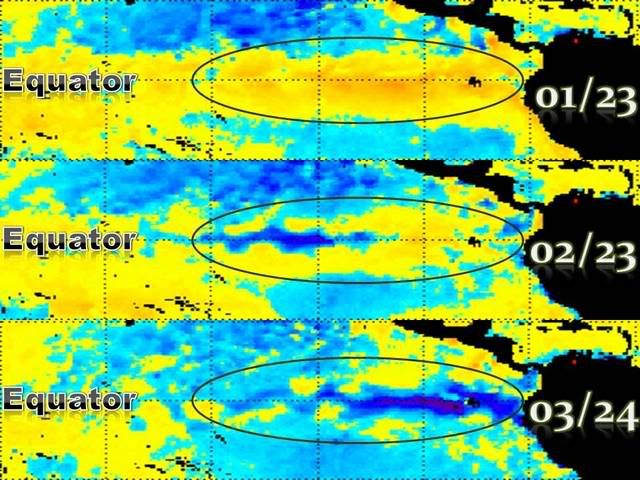
Plymouth Anomalies update
Certainly the cool waters have expanded all the way from the western Southamerican coast to around 120w with lesser cooler waters west of that longitud.
Certainly the cool waters have expanded all the way from the western Southamerican coast to around 120w with lesser cooler waters west of that longitud.
0 likes
-
James

- Category 5
- Posts: 1531
- Joined: Tue Aug 24, 2004 10:29 am
- Location: Gloucestershire, England
- Contact:
Great graphic there. The cooling over recent months has been quite intense clearly. Looking at the pictures it seems as though the anomalies today may not be quite as pronounced as they were this time last year, but am I right in thinking that since there is more cooler water below the surface this year some further cooling will occur?
0 likes
-
SouthFloridawx

- S2K Supporter

- Posts: 8346
- Age: 47
- Joined: Tue Jul 26, 2005 1:16 am
- Location: Sarasota, FL
- Contact:
Subsurface Temps show a gradual expansion of the cool temps across the equator. I would say that these cool temps are going to remain cool for at least a couple more months.
[web]http://www.cpc.ncep.noaa.gov/products/analysis_monitoring/ocean/anim/wkxzteq_anm.gif[/web]
Got a question...
[web]http://www.cpc.ncep.noaa.gov/products/analysis_monitoring/enso_update/uv850-30d.gif[/web]
Looking at the 850-hpa winds, we see a pocket, what appears to be above normal winds from 160E to 135W... Will these above normal in Region #4 and in 3.4 to spread Eastward? I don't know quite enough about ENSO, but if this is the case and these above normal wind anomalies continue, most likely we will see continued cooling or at least keep the ssts and sub-surface temps below normal.
[web]http://www.srh.noaa.gov/mlb/enso/images/nino-regions.gif[/web]
0 likes
-
cycloneye
- Admin
- Posts: 149392
- Age: 69
- Joined: Thu Oct 10, 2002 10:54 am
- Location: San Juan, Puerto Rico

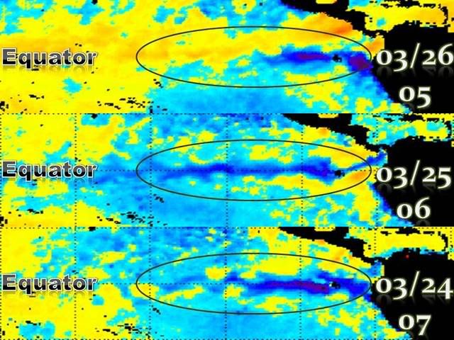
Here are the very latest anomalies data in the Pacific.
0 likes
Visit the Caribbean-Central America Weather Thread where you can find at first post web cams,radars
and observations from Caribbean basin members Click Here
and observations from Caribbean basin members Click Here
-
Hurricaneman

- Category 5
- Posts: 7404
- Age: 45
- Joined: Tue Aug 31, 2004 3:24 pm
- Location: central florida
-
AussieMark

- Category 5
- Posts: 5857
- Joined: Tue Sep 02, 2003 6:36 pm
- Location: near Sydney, Australia
Remember La Nina is based on Nino 3.4 region
the area you should be looking at is
5°N-5°S, 120°-170°W
its not neccesarily the region right on the South America coast which has the most intense cooling
just mean I can't see La Nina being declared in the next 2 weeks
then when it does cool down to -0.5 or colder you need a trend before it is declared.
Altho NOAA did declare El Nino early last year so you never know
0 likes
-
cycloneye
- Admin
- Posts: 149392
- Age: 69
- Joined: Thu Oct 10, 2002 10:54 am
- Location: San Juan, Puerto Rico
Climate Prediction Center March 26 Update

NOAA has ENSO right now as Neutral with La Nina being declared during the next 3 months.Read the March 26th update from CPC at link above.
NOAA has ENSO right now as Neutral with La Nina being declared during the next 3 months.Read the March 26th update from CPC at link above.
0 likes

cycloneye wrote:Climate Prediction Center March 26 Update
NOAA has ENSO right now as Neutral with La Nina being declared during the next 3 months.Read the March 26th update from CPC at link above.
Not good.That means conditions will be ripe for one hec of an active Atlantic cane season.There will be alot of named storms.I just hope they don't enter the Gulf or slam into the east coast
0 likes
-
HURAKAN

- Professional-Met

- Posts: 46084
- Age: 39
- Joined: Thu May 20, 2004 4:34 pm
- Location: Key West, FL
- Contact:
canegrl04 wrote:cycloneye wrote:Climate Prediction Center March 26 Update
NOAA has ENSO right now as Neutral with La Nina being declared during the next 3 months.Read the March 26th update from CPC at link above.
Not good.That means conditions will be ripe for one hec of an active Atlantic cane season.There will be alot of named storms.I just hope they don't enter the Gulf or slam into the east coast
Active seasons usually don't grant you that kind of wishes.
0 likes
-
Hybridstorm_November2001

- S2K Supporter
- Posts: 2817
- Joined: Sat Aug 21, 2004 2:50 pm
- Location: SW New Brunswick, Canada
- Contact:
-
HouTXmetro

- Category 5
- Posts: 3949
- Joined: Sun Jun 13, 2004 6:00 pm
- Location: District of Columbia, USA
-
GeneratorPower

- S2K Supporter
- Posts: 1648
- Age: 46
- Joined: Sun Dec 18, 2005 11:48 pm
- Location: Huntsville, AL
-
meteorologyman
- Category 2
- Posts: 541
- Joined: Wed Mar 15, 2006 6:48 pm
- Location: Florida, Kissimmee/St.CLoud
More Bad news for this 2007 Hurricane Season forecast. 

http://tsr.mssl.ucl.ac.uk/docs/TSR_Release20Mar2007.pdf
http://tsr.mssl.ucl.ac.uk/docs/TSR_Release20Mar2007.pdf
0 likes
-
AussieMark
- Category 5
- Posts: 5857
- Joined: Tue Sep 02, 2003 6:36 pm
- Location: near Sydney, Australia
Summary: Pacific cooling slows, conditions currently neutral
Central to eastern Pacific sea-surface temperatures have remained close to average during March, following the rapid cooling that took place during January and February at the end of the 2006/07 El Niño event. The SOI, Trade Winds and Pacific cloud patterns are other ENSO indicators which are currently in a neutral phase. There appears to be little chance of a return to El Niño conditions in 2007, with a continuation of neutral, or a switch to La Niña conditions, the more likely outcomes.
A La Niña in 2007?
The chance of a La Niña developing in 2007 is thought to be higher than the long-term average (which is about one in five or 20%) because (a) they have a tendency to follow an El Niño; (b) the 2006/07 El Niño decayed somewhat earlier than normal thereby giving time for a La Niña to begin developing during the critical March to June period; and (c) a large pool of cold sub-surface water remains in the central to eastern tropical Pacific Ocean and is starting to affect surface temperatures in the region. La Niña events are generally associated with wetter than normal conditions across much of the eastern half of the country from about autumn.

In Brief
* Equatorial Pacific SST anomalies are below zero in the eastern equatorial Pacific.
* Negative subsurface anomalies have strengthened in the eastern equatorial Pacific.
* The SOI has a current (26th March) 30-day value of approximately +4.
* Trade Winds have generally been close to or somewhat stronger than average in the western Pacific during February and March.
* Cloudiness near the date-line has recently been close to or slightly below average.
* Many computer models predict further cooling of the Pacific during the first half of 2007, with all predicting a continuation of neutral or the development of La Niña conditions.
Source
Central to eastern Pacific sea-surface temperatures have remained close to average during March, following the rapid cooling that took place during January and February at the end of the 2006/07 El Niño event. The SOI, Trade Winds and Pacific cloud patterns are other ENSO indicators which are currently in a neutral phase. There appears to be little chance of a return to El Niño conditions in 2007, with a continuation of neutral, or a switch to La Niña conditions, the more likely outcomes.
A La Niña in 2007?
The chance of a La Niña developing in 2007 is thought to be higher than the long-term average (which is about one in five or 20%) because (a) they have a tendency to follow an El Niño; (b) the 2006/07 El Niño decayed somewhat earlier than normal thereby giving time for a La Niña to begin developing during the critical March to June period; and (c) a large pool of cold sub-surface water remains in the central to eastern tropical Pacific Ocean and is starting to affect surface temperatures in the region. La Niña events are generally associated with wetter than normal conditions across much of the eastern half of the country from about autumn.
In Brief
* Equatorial Pacific SST anomalies are below zero in the eastern equatorial Pacific.
* Negative subsurface anomalies have strengthened in the eastern equatorial Pacific.
* The SOI has a current (26th March) 30-day value of approximately +4.
* Trade Winds have generally been close to or somewhat stronger than average in the western Pacific during February and March.
* Cloudiness near the date-line has recently been close to or slightly below average.
* Many computer models predict further cooling of the Pacific during the first half of 2007, with all predicting a continuation of neutral or the development of La Niña conditions.
Source
0 likes
-
cycloneye
- Admin
- Posts: 149392
- Age: 69
- Joined: Thu Oct 10, 2002 10:54 am
- Location: San Juan, Puerto Rico
This will be flipping between Neutral and weak la nina in the next couple of months.The question is,during the heart of the season,how ENSO will be.Will it remain Neutral all the way during the season,or it will turn to La Nina during that period?
0 likes
Visit the Caribbean-Central America Weather Thread where you can find at first post web cams,radars
and observations from Caribbean basin members Click Here
and observations from Caribbean basin members Click Here
Who is online
Users browsing this forum: Google [Bot], hcane27 and 235 guests