2007 TCHP GOM:

2005 TCHP GOM:

2007 SST's GOM:

2005 SST's GOM:

Moderator: S2k Moderators


2006 featured a moderate El Nino event. El Nino is not expected in 2007. 2006 also had extreme SAL. 2007 is not expected to have an El Nino and wind shear is expected to drop to below average levels during July.windstorm99 wrote:Not sure what you mean by horrific but 2006 also had very warm SST'S and 90 percent of the tropical cyclone's that formed stated out to sea.I hopeing for a quite season as folks along the gulf coast are still trying to put there lives back together after katrina.Numbers are not important as the ones that actually hit land are the ones the have the greatest impact.SST'S play a significant role on tropical cyclone development but at the same time its only a small portion of things that have to be in place for a tropical cyclone to flurish.Adrian
www.Adrian's Weather.com
miamicanes177 wrote:2006 featured a moderate El Nino event. El Nino is not expected in 2007. 2006 also had extreme SAL. 2007 is not expected to have an El Nino and wind shear is expected to drop to below average levels during July.windstorm99 wrote:Not sure what you mean by horrific but 2006 also had very warm SST'S and 90 percent of the tropical cyclone's that formed stated out to sea.I hopeing for a quite season as folks along the gulf coast are still trying to put there lives back together after katrina.Numbers are not important as the ones that actually hit land are the ones the have the greatest impact.SST'S play a significant role on tropical cyclone development but at the same time its only a small portion of things that have to be in place for a tropical cyclone to flurish.Adrian
www.Adrian's Weather.com
hawkeh wrote:I've been keeping an eye on the THCP content every other day and it really has increased a lot this past week or so, we may be in for a rough season if this keeps up?
Can anyone post the THCP image from the 05 season for the whole atlantic please?


Tampa Bay Hurricane wrote:It does appear that since jeff masters has indicated a possibility
a strong possibility for well below normal shear
into July...
Those caribbean oceanic heat contents are
VERY DISTURBING to me...if any storm
gets over that with the forecasted reduced
shear we could see very explosive
activity this year with the caribbean seeing
storms as strong if not stronger
than storms in 2005 if the shear lowers
as it is forecasted to do...
note that the subtropical jet gets
shunted further north leaving less shear
over the GOM and atlantic and caribbean
for that matter.
Folks these graphics are VERY VERY SCARY
to me and I am VERY WORRIED about a
very bad hurricane season for the caribbean
so folks in the caribbean i'd be prepared....
Note that much of the Caribbean ocean heat
content can now support sub-880 mb hurricanes:
http://wxmaps.org/pix/hurpot.html#ATL
SST's are warmer than 2005 in the areas that scare people the most, around land areas. Out in the open Atlantic the SST's are just slightly cooler, but warm enough to support development which is all that matters.wxmann_91 wrote:The SST's aren't as hot right now as they were in 2005, to start.


Aquawind wrote:It's kind of amazing how much the 2005 year is used for comparisons and will be for years to come. Not just for SSTs of course. The Gulf waters warmed for sure this week as the cloud cover was limited and the winds were light. The Bahamas had some cloud cover and more rain. I would expect to see even more warming anomalies on the weekly Reynolds graphics developed this last week for the most part and with a cooling in the central Atl were the +2F was. I certainly don't think SSTs are going to be a limiting factor in comparison to a average hurricane season and if the other factors like shear cooperate sure well above average is reasonable.
wxmann_91 wrote:Also I think the background pressures are higher (I'll have to check into that to see if that's correct or not, though).

Cyclenall wrote:wxmann_91 wrote:Also I think the background pressures are higher (I'll have to check into that to see if that's correct or not, though).
I was wondering if there was a why to "measure" that or not. How do to compare something like that to other years? I think the only way would be a map of some sort like SST maps to show the background pressures.
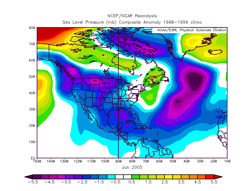
wxmann_91 wrote:There is a way...
June 2007 data will take some time to come out, but here was June 2005 data. Needless to say, it speaks for itself.
(map from http://www.cdc.noaa.gov/cgi-bin/Composites/printpage.pl )
*cut*
Users browsing this forum: No registered users and 66 guests


