east hatteras bouy 11pm sustained winds at 50 mph gusts to 66mph pressure down to 29.70 next update 15 min
http://www.ssd.noaa.gov/goes/east/nwatl/loop-wv.html moving right over bouy soon
Analysis,Models,Sat Pics of Low in Western Atlantic
Moderator: S2k Moderators
Forum rules

The posts in this forum are NOT official forecasts and should not be used as such. They are just the opinion of the poster and may or may not be backed by sound meteorological data. They are NOT endorsed by any professional institution or STORM2K. For official information, please refer to products from the National Hurricane Center and National Weather Service.
-
GeneratorPower

- S2K Supporter

- Posts: 1648
- Age: 46
- Joined: Sun Dec 18, 2005 11:48 pm
- Location: Huntsville, AL
-
Matt-hurricanewatcher
http://www.ndbc.noaa.gov/station_page.php?station=41001
54 knot one minute winds, with 69 knot gust. Very strong one minute winds, more like a warmer core system with the high one minute winds.
54 knot one minute winds, with 69 knot gust. Very strong one minute winds, more like a warmer core system with the high one minute winds.
0 likes
-
Matt-hurricanewatcher
-
kevin
-
Coredesat
kevin wrote:Its organizing, the pressure is dropping and its diving towards the south. I expect this to be named tomorrow.
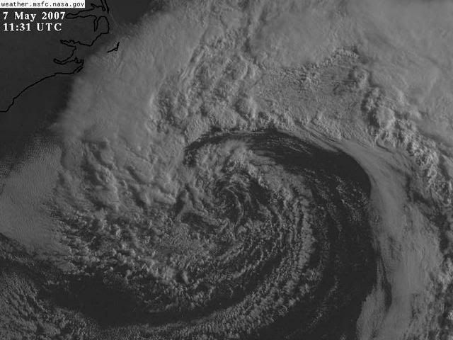
Now now, hold your horses, it's still cold core, frontal, and there's no deep convection near the center. That blue isn't deep convection. There's 30 kt of mid-level and 50 kt of upper-level shear over the system, and it's over 17-20C SSTs. Also, there's a substantial dry slot:

The strengthening it's undergoing appears to be baroclinic for now, and it won't be over favorable SSTs for a couple more days. I hate to be a party pooper, but this isn't going to be anything until then.
Last edited by Coredesat on Mon May 07, 2007 12:54 am, edited 1 time in total.
0 likes
-
Matt-hurricanewatcher
-
Coredesat


The buoy 150nm east of Cape Hatteras picked up a gust of 70knots with waves over 30 feet. With a storm that stirred up the ocean so fast my concern is for mariners trapped out there.
http://www.ndbc.noaa.gov/show_plot.php?station=41001&meas=wdpr&uom=E
http://www.ndbc.noaa.gov/show_plot.php?station=41001&meas=wdpr&uom=E
0 likes
-
wxman57

- Moderator-Pro Met

- Posts: 23172
- Age: 68
- Joined: Sat Jun 21, 2003 8:06 pm
- Location: Houston, TX (southwest)
Matt-hurricanewatcher wrote:http://www.ndbc.noaa.gov/station_page.php?station=41001
54 knot one minute winds, with 69 knot gust. Very strong one minute winds, more like a warmer core system with the high one minute winds.
Strong winds don't make this a warm core low. It's purely cold core all the way now. Plenty of cold dry air flowing into the center off the SE US coast. Such lows CAN become TS/STS, but such a transition takes quite a number of days. This low won't be offshore long enough for such a transition to occur, most likely.
0 likes
sliding SW this strom had bouy 41001 at 1250 and 150
sustained at at 60mph and gusts to past hurricane force 78 mph wow then it eased up as storm slid SW
MODEL SUITE HAS SLOWLY CONVERGED ON A MORE SOUTHERLY...NAM-LIKE
SOLN FOR THE COASTAL LOW. with the storm going inland on WEDnesday around GA/sc border and may end up in North. florida as a weakened shadow of it's self
995 mb as of 4am
per 4 am charleston SC noaa discusion
swell forecast now to be 15 feet at a 13 second interval in the palm beaches delray beach and north lake worth inlet will be amazing
0 likes


AFD Jax:
AREA FORECAST DISCUSSION
NATIONAL WEATHER SERVICE JACKSONVILLE FL
308 AM EDT MON MAY 7 2007
...NOR`EASTER TO BRING WINDY CONDITIONS THROUGH TUESDAY...
.SHORT TERM...VIGOROUS LOW PRESSURE SYSTEM IS CURRENTLY POSITIONED
OFF THE CAROLINA COASTLINE WITH CURRENT PRESSURE READING NEAR 995
MB. MEANWHILE...LARGE HIGH PRESSURE SYSTEM HAS ENVELOPED MUCH OF
THE EASTERN UNITED STATES...WITH PRESSURE READINGS EXCEEDING 1035
MB OVER PORTIONS OF THE NEW ENGLAND STATES. THIS HAS BROUGHT A
VERY TIGHT NORTHERLY GRADIENT OVER THE LOCAL AREA WITH CURRENT
SUSTAINED WINDS OF 20 TO 25 MPH ACROSS OUR COASTAL COUNTIES...WITH
GUSTS TO 35 MPH ALONG THE IMMEDIATE COASTLINE.
AFOREMENTIONED LOW IS FORECAST TO ADVANCE SOUTH OVER THE ATLANTIC
WATERS TODAY WITH PRESSURE RISES CONTINUING OVER THE MAINLAND. AS
A RESULT...WILL MAINTAIN WIND ADVISORIES FOR COASTAL COUNTIES...WITH
LAKE WIND ADVISORY CONDITIONS IMPACTING INTERIOR COUNTIES BY MID-
MORNING. MSAS ANALYSIS INDICATES MUCH DRIER AIR IS FILTERING IN
FROM THE NORTH...WITH CURRENT DEWPOINT READINGS AROUND 35 ACROSS
OUR NORTHERN-MOST COUNTIES. THUS...WILL MAINTAIN DRY CONDITIONS
FOR TODAY BUT CANNOT RULE OUT A FEW SPRINKLES ACROSS FLAGLER
COUNTY AND POSSIBLY SOUTHERN ST. JOHNS COUNTY TODAY WHERE DEWPOINT
READINGS WILL BE HIGHEST COUPLED WITH WEAK LIFT ASSOCIATED WITH
SURFACE MOISTURE FLUX CONVERGENCE.
TONIGHT...VIGOROUS LOW IS FORECAST TO ADVANCE SOUTH OVER THE
ATLANTIC WATERS...WITH LOCAL WINDS EXPECTED TO BACK FROM NORTHEAST
TO NORTH. THIS WOULD MAINTAIN DRY CONDITIONS ACROSS THE LOCAL AREA.
WILL CONTINUE WIND ADVISORY FOR COASTAL COUNTIES WITH LAKE WIND
ADVISORY FOR MOST 1ST TIER INTERIOR COUNTIES.
TUESDAY THROUGH WEDNESDAY...LATEST COMPUTER MODEL GUIDANCE BRINGS
SURFACE LOW TOWARDS THE LOCAL COASTLINE BY WEDNESDAY AND IF THIS
SCENARIO IS REALIZED...WOULD BRING BENEFICIAL RAINFALL TO AT LEAST
EASTERN HALF OF JAX CWA BY WEDNESDAY. HAVE INCREASED POPS IN
RESPONSE TO THIS...AND WOULD NOT BE SURPRISED TO SEE SHARP RAINFALL
DISTRIBUTION IF LOW PRESSURE MEANDERS JUST OFFSHORE. WILL MAINTAIN
LAKE WIND/WIND ADVISORIES THROUGH TUESDAY EVENING.
THE EXACT TRACK OF THIS SYSTEM IS STILL UNCERTAIN AND RESIDENTS OF
NORTHEAST FLORIDA AND SOUTHEAST GEORGIA SHOULD MONITOR FUTURE
FORECASTS.
0 likes
-
HURAKAN

- Professional-Met

- Posts: 46084
- Age: 39
- Joined: Thu May 20, 2004 4:34 pm
- Location: Key West, FL
- Contact:
07/0545 UTC 33.3N 72.5W ST2.5/2.5 90L -- Atlantic Ocean
Invest 90L anyone?!?!?!?!
http://www.ssd.noaa.gov/PS/TROP/positions.html
Invest 90L anyone?!?!?!?!
http://www.ssd.noaa.gov/PS/TROP/positions.html
0 likes
-
cycloneye

- Admin

- Posts: 149280
- Age: 69
- Joined: Thu Oct 10, 2002 10:54 am
- Location: San Juan, Puerto Rico
HURAKAN wrote:07/0545 UTC 33.3N 72.5W ST2.5/2.5 90L -- Atlantic Ocean
Invest 90L anyone?!?!?!?!
http://www.ssd.noaa.gov/PS/TROP/positions.html
0 likes
Visit the Caribbean-Central America Weather Thread where you can find at first post web cams,radars
and observations from Caribbean basin members Click Here
and observations from Caribbean basin members Click Here
-
Extremeweatherguy

- Category 5

- Posts: 11095
- Joined: Mon Oct 10, 2005 8:13 pm
- Location: Florida
-
cycloneye
- Admin
- Posts: 149280
- Age: 69
- Joined: Thu Oct 10, 2002 10:54 am
- Location: San Juan, Puerto Rico
Extremeweatherguy wrote:so this is 90L now?
Not yet.Until the models start runs it wont be up at NRL.But this dvorak data is a hint that they are thinking to pop it later today.
0 likes
Visit the Caribbean-Central America Weather Thread where you can find at first post web cams,radars
and observations from Caribbean basin members Click Here
and observations from Caribbean basin members Click Here
Who is online
Users browsing this forum: Kingarabian and 245 guests