https://twitter.com/webberweather/status/1304896913284702208
2020 Global Model Runs Discussion (Out thru day 16)
Moderator: S2k Moderators
Forum rules

The posts in this forum are NOT official forecasts and should not be used as such. They are just the opinion of the poster and may or may not be backed by sound meteorological data. They are NOT endorsed by any professional institution or STORM2K. For official information, please refer to products from the National Hurricane Center and National Weather Service.
-
SFLcane

- S2K Supporter

- Posts: 10281
- Age: 48
- Joined: Sat Jun 05, 2010 1:44 pm
- Location: Lake Worth Florida
Re: 2020 Global Model Runs Discussion (Out thru day 16)
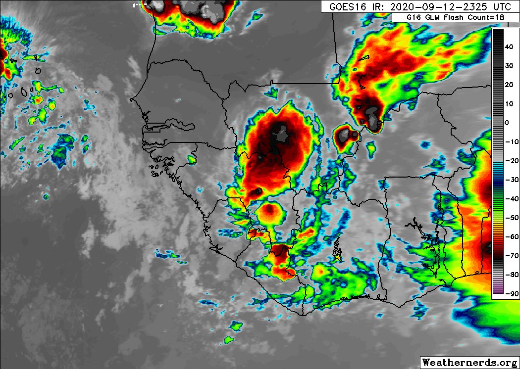
Here is the wave some of the guidance is developing.
1 likes

Re: 2020 Global Model Runs Discussion (Out thru day 16)
SFLcane wrote:Here is the wave some of the guidance is developing.
https://i.postimg.cc/13Ngm6cM/63-D44-C38-13-B6-47-F4-B49-B-D0-A8-F47282-F5.jpg
What's that behind it?
0 likes
-
StPeteMike

- Category 2

- Posts: 653
- Joined: Thu Jun 07, 2018 11:26 pm
Re: 2020 Global Model Runs Discussion (Out thru day 16)
St0rmTh0r wrote:SFLcane wrote:Here is the wave some of the guidance is developing.
https://i.postimg.cc/13Ngm6cM/63-D44-C38-13-B6-47-F4-B49-B-D0-A8-F47282-F5.jpg
What's that behind it?
Hurricane Alpha likely
2 likes
The above post is not official and should not be used as such. It is the opinion of the poster and may or may not be backed by sound meteorological data. It is not endorsed by any professional institution or storm2k.org. For official information, please refer to the NHC and NWS products.
-
StPeteMike
- Category 2
- Posts: 653
- Joined: Thu Jun 07, 2018 11:26 pm
Re: 2020 Global Model Runs Discussion (Out thru day 16)
ICON has a Gulfbrew shortly after Sally starts moving out and looks like another system just off the coast of the Carolinas at the same time  https://www.tropicaltidbits.com/analysi ... 1300&fh=51
https://www.tropicaltidbits.com/analysi ... 1300&fh=51
3 likes
The above post is not official and should not be used as such. It is the opinion of the poster and may or may not be backed by sound meteorological data. It is not endorsed by any professional institution or storm2k.org. For official information, please refer to the NHC and NWS products.
-
jlauderdal
- S2K Supporter
- Posts: 7240
- Joined: Wed May 19, 2004 5:46 am
- Location: NE Fort Lauderdale
- Contact:
Re: 2020 Global Model Runs Discussion (Out thru day 16)
cold fronts only make it through south Florida in late September on model runs, the reality is they get hung up around orlandoTheStormExpert wrote:SFLcane wrote:12z Euro a tad weaker has a TC moving into the Caribbean.
https://i.postimg.cc/HsRgSmtr/4-C795-F80-EF37-4-DD0-B4-B9-E402-DCC0-ECA0.gif
Is that a cold front actually making it all the way through Florida into the straights in late-September!?

2 likes
-
SFLcane
- S2K Supporter
- Posts: 10281
- Age: 48
- Joined: Sat Jun 05, 2010 1:44 pm
- Location: Lake Worth Florida
Re: 2020 Global Model Runs Discussion (Out thru day 16)
Global much less enthusiastic about development with this next wave and EPS long range is fairly quite.
Edit: Now with 0-20% development in 5 days by NHC.
Edit: Now with 0-20% development in 5 days by NHC.
1 likes

Re: 2020 Global Model Runs Discussion (Out thru day 16)
Quiet models = no bueno. I see long range models suggesting quiet as much more worrisome. As long as Africa can keep pumping out East and Central Atlantic storms, us mammals west of 60W should be marginally safe. Beyond Paulette's risk to Bermuda, I think we're just at that point where we are seeing a good deal more meridianal troughing over the CONUS and Atlantic overall and the dominant strong mid level heights across the Atlantic have weakened and become far more cellular allowing for weaknesses to form between them. As such, eastern MDR systems will have a hard time traversing the entire Atlantic before re-curving. As I see it, additional tropical cyclones developing well east of 50W will remain eye-candy. On the other hand, tropical waves that remain under the radar and not developing until reaching the Caribbean or just north of the Greater Antilles (i.e. Sally) will be those posing any landfall concern moving forward. Prediction: After Sally ..... the next landfall will mark the beginning of this years' Greek Festival
3 likes
Andy D
(For official information, please refer to the NHC and NWS products.)
(For official information, please refer to the NHC and NWS products.)
-
TheStormExpert
Re: 2020 Global Model Runs Discussion (Out thru day 16)
According to the 12z GFS we might have to watch the area near Bermuda in 8-10 days from the trough that pushes TD #20 OTS for Subtropical or Tropical development.
1 likes
-
TheStormExpert
Re: 2020 Global Model Runs Discussion (Out thru day 16)
chaser1 wrote:Quiet models = no bueno. I see long range models suggesting quiet as much more worrisome. As long as Africa can keep pumping out East and Central Atlantic storms, us mammals west of 60W should be marginally safe. Beyond Paulette's risk to Bermuda, I think we're just at that point where we are seeing a good deal more meridianal troughing over the CONUS and Atlantic overall and the dominant strong mid level heights across the Atlantic have weakened and become far more cellular allowing for weaknesses to form between them. As such, eastern MDR systems will have a hard time traversing the entire Atlantic before re-curving. As I see it, additional tropical cyclones developing well east of 50W will remain eye-candy. On the other hand, tropical waves that remain under the radar and not developing until reaching the Caribbean or just north of the Greater Antilles (i.e. Sally) will be those posing any landfall concern moving forward. Prediction: After Sally ..... the next landfall will mark the beginning of this years' Greek Festival
We might see a VERY brief lull like we’ve seen a few times this season before the MJO moves back into our region late-September.
0 likes
Re: 2020 Global Model Runs Discussion (Out thru day 16)
TheStormExpert wrote:chaser1 wrote:Quiet models = no bueno. I see long range models suggesting quiet as much more worrisome. As long as Africa can keep pumping out East and Central Atlantic storms, us mammals west of 60W should be marginally safe. Beyond Paulette's risk to Bermuda, I think we're just at that point where we are seeing a good deal more meridianal troughing over the CONUS and Atlantic overall and the dominant strong mid level heights across the Atlantic have weakened and become far more cellular allowing for weaknesses to form between them. As such, eastern MDR systems will have a hard time traversing the entire Atlantic before re-curving. As I see it, additional tropical cyclones developing well east of 50W will remain eye-candy. On the other hand, tropical waves that remain under the radar and not developing until reaching the Caribbean or just north of the Greater Antilles (i.e. Sally) will be those posing any landfall concern moving forward. Prediction: After Sally ..... the next landfall will mark the beginning of this years' Greek Festival
We might see a VERY brief lull like we’ve seen a few times this season before the MJO moves back into our region late-September.
Yep, that's about the period that worries me. Course, that doesn't exclude the possibility of another "Sally" esq development between now and then but at least for now, it seems all the "loud barking dogs" are way down the street in someone's fenced yard LOL.
0 likes
Andy D
(For official information, please refer to the NHC and NWS products.)
(For official information, please refer to the NHC and NWS products.)
Re: 2020 Global Model Runs Discussion (Out thru day 16)
TheStormExpert wrote:According to the 12z GFS we might have to watch the area near Bermuda in 8-10 days from the trough that pushes TD #20 OTS for Subtropical or Tropical development.
Another potential “ridge over troubled water” homegrown. Also, there are hints thus could form closer to the SE US and not be a definite OTS from the E coast. Long ways out.
0 likes
Personal Forecast Disclaimer:
The posts in this forum are NOT official forecasts and should not be used as such. They are just the opinion of the poster and may or may not be backed by sound meteorological data. They are NOT endorsed by any professional institution or storm2k.org. For official information, please refer to the NHC and NWS products.
The posts in this forum are NOT official forecasts and should not be used as such. They are just the opinion of the poster and may or may not be backed by sound meteorological data. They are NOT endorsed by any professional institution or storm2k.org. For official information, please refer to the NHC and NWS products.
Re: 2020 Global Model Runs Discussion (Out thru day 16)
Check out the 240 hour 12Z Euro for something that is interesting though it likely won't actually happen: Paulette ends up SE of future Teddy: yes, that's Paulette way out there near 30N, 44W!

0 likes
Personal Forecast Disclaimer:
The posts in this forum are NOT official forecasts and should not be used as such. They are just the opinion of the poster and may or may not be backed by sound meteorological data. They are NOT endorsed by any professional institution or storm2k.org. For official information, please refer to the NHC and NWS products.
The posts in this forum are NOT official forecasts and should not be used as such. They are just the opinion of the poster and may or may not be backed by sound meteorological data. They are NOT endorsed by any professional institution or storm2k.org. For official information, please refer to the NHC and NWS products.
Re: 2020 Global Model Runs Discussion (Out thru day 16)
Per 12Z EPS: watch for possible homegrown offshore the SE US next week. May never amount to any threat, but worth watching imo especially with it being La Niña.
0 likes
Personal Forecast Disclaimer:
The posts in this forum are NOT official forecasts and should not be used as such. They are just the opinion of the poster and may or may not be backed by sound meteorological data. They are NOT endorsed by any professional institution or storm2k.org. For official information, please refer to the NHC and NWS products.
The posts in this forum are NOT official forecasts and should not be used as such. They are just the opinion of the poster and may or may not be backed by sound meteorological data. They are NOT endorsed by any professional institution or storm2k.org. For official information, please refer to the NHC and NWS products.
Re: 2020 Global Model Runs Discussion (Out thru day 16)
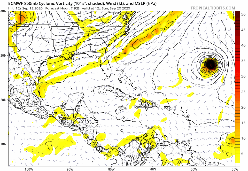
A bigger concern to me than any current AEW, a potential follow-up to Sally "ridge over troubled water" homegrown next week similar to this, made more of a concern because of La Nina:

1 likes
Personal Forecast Disclaimer:
The posts in this forum are NOT official forecasts and should not be used as such. They are just the opinion of the poster and may or may not be backed by sound meteorological data. They are NOT endorsed by any professional institution or storm2k.org. For official information, please refer to the NHC and NWS products.
The posts in this forum are NOT official forecasts and should not be used as such. They are just the opinion of the poster and may or may not be backed by sound meteorological data. They are NOT endorsed by any professional institution or storm2k.org. For official information, please refer to the NHC and NWS products.
-
TheStormExpert
Re: 2020 Global Model Runs Discussion (Out thru day 16)
LarryWx wrote:A bigger concern to me than any current AEW, a potential follow-up to Sally "ridge over troubled water" homegrown next week similar to this, made more of a concern because of La Nina:
https://i.imgur.com/NeTjcIk.png
So why is this more of a concern during a La Niña season versus an El Niño one?
0 likes
Re: 2020 Global Model Runs Discussion (Out thru day 16)
TheStormExpert wrote:LarryWx wrote:A bigger concern to me than any current AEW, a potential follow-up to Sally "ridge over troubled water" homegrown next week similar to this, made more of a concern because of La Nina:
https://i.imgur.com/NeTjcIk.png
So why is this more of a concern during a La Niña season versus an El Niño one?
Because I believe that upper winds have a higher chance to return to favorable more quickly via the reestablishment of W Atl and E US/SE US ridging. That ridging in general is more prevalent during Niña vs Niño meaning generally lighter shear, especially as we get into the late season.
Last edited by LarryWx on Sun Sep 13, 2020 9:24 pm, edited 1 time in total.
0 likes
Personal Forecast Disclaimer:
The posts in this forum are NOT official forecasts and should not be used as such. They are just the opinion of the poster and may or may not be backed by sound meteorological data. They are NOT endorsed by any professional institution or storm2k.org. For official information, please refer to the NHC and NWS products.
The posts in this forum are NOT official forecasts and should not be used as such. They are just the opinion of the poster and may or may not be backed by sound meteorological data. They are NOT endorsed by any professional institution or storm2k.org. For official information, please refer to the NHC and NWS products.


Re: 2020 Global Model Runs Discussion (Out thru day 16)
I haven't been paying attention to the models lately, do any of them have Rene re-energizing, or Sally reforming whenever/wherever she comes back off shore.
0 likes
Personal Forecast Disclaimer:
The posts in this forum are NOT official forecast and should not be used as such. They are just the opinion of the poster and may or may not be backed by sound meteorological data. They are NOT endorsed by any professional institution or storm2k.org. For official information, please refer to the NHC and NWS products.
The posts in this forum are NOT official forecast and should not be used as such. They are just the opinion of the poster and may or may not be backed by sound meteorological data. They are NOT endorsed by any professional institution or storm2k.org. For official information, please refer to the NHC and NWS products.
-
SFLcane
- S2K Supporter
- Posts: 10281
- Age: 48
- Joined: Sat Jun 05, 2010 1:44 pm
- Location: Lake Worth Florida
Re: 2020 Global Model Runs Discussion (Out thru day 16)
Not to much left of this capeverde season. We shall see if anything tries to get going in the Caribbean In October but I would not hold my breath.
https://twitter.com/mjventrice/status/1305483780233351169
https://twitter.com/mjventrice/status/1305483780233351169
0 likes
-
Loveweather12
- Tropical Storm

- Posts: 136
- Joined: Thu Aug 20, 2020 2:37 pm
Re: 2020 Global Model Runs Discussion (Out thru day 16)
Are you saying the season is over after September ?

SFLcane wrote:Not to much left of this capeverde season. We shall see if anything tries to get going in the Caribbean In October but I would not hold my breath.
https://twitter.com/mjventrice/status/1305483780233351169?
0 likes
Who is online
Users browsing this forum: pepecool20, zal0phus and 52 guests