
This is reminding me of how hostile conditions generally were until we had Harvey form in the Gulf in 2017.
2022 Indicators (SSTs/SAL/MSLP/Shear/Steering/Instability) and >Day 16 Models
Moderator: S2k Moderators
Forum rules

The posts in this forum are NOT official forecasts and should not be used as such. They are just the opinion of the poster and may or may not be backed by sound meteorological data. They are NOT endorsed by any professional institution or STORM2K. For official information, please refer to products from the National Hurricane Center and National Weather Service.
-
captainbarbossa19

- Professional-Met

- Posts: 1094
- Age: 27
- Joined: Wed Aug 21, 2019 11:09 pm
- Location: Beaumont, TX
Re: 2022 Indicators (SSTs/SAL/MSLP/Shear/Steering/Instability) and >Day 16 Models
This is reminding me of how hostile conditions generally were until we had Harvey form in the Gulf in 2017.
1 likes
-
SFLcane

- S2K Supporter

- Posts: 10281
- Age: 48
- Joined: Sat Jun 05, 2010 1:44 pm
- Location: Lake Worth Florida
Re: 2022 Indicators (SSTs/SAL/MSLP/Shear/Steering/Instability) and >Day 16 Models
Teban54 wrote:
That's still early August. Nothing unexpected IMO.

0 likes
-
SFLcane
- S2K Supporter
- Posts: 10281
- Age: 48
- Joined: Sat Jun 05, 2010 1:44 pm
- Location: Lake Worth Florida
Re: 2022 Indicators (SSTs/SAL/MSLP/Shear/Steering/Instability) and >Day 16 Models
The CSU update next week will definitely be interesting next week.
How low will Phil go?
How low will Phil go?
Last edited by SFLcane on Thu Jul 28, 2022 1:26 pm, edited 1 time in total.
0 likes

Re: 2022 Indicators (SSTs/SAL/MSLP/Shear/Steering/Instability) and >Day 16 Models
Teban54 wrote:
That's still early August. Nothing unexpected IMO.
Exactly! What do people not understand about that? Lol
0 likes
-
gatorcane

- S2K Supporter
- Posts: 23708
- Age: 48
- Joined: Sun Mar 13, 2005 3:54 pm
- Location: Boca Raton, FL
Re: 2022 Indicators (SSTs/SAL/MSLP/Shear/Steering/Instability) and >Day 16 Models
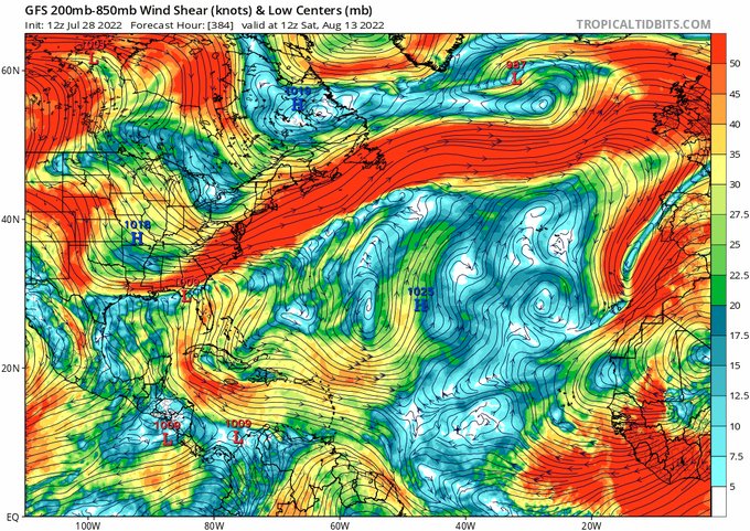
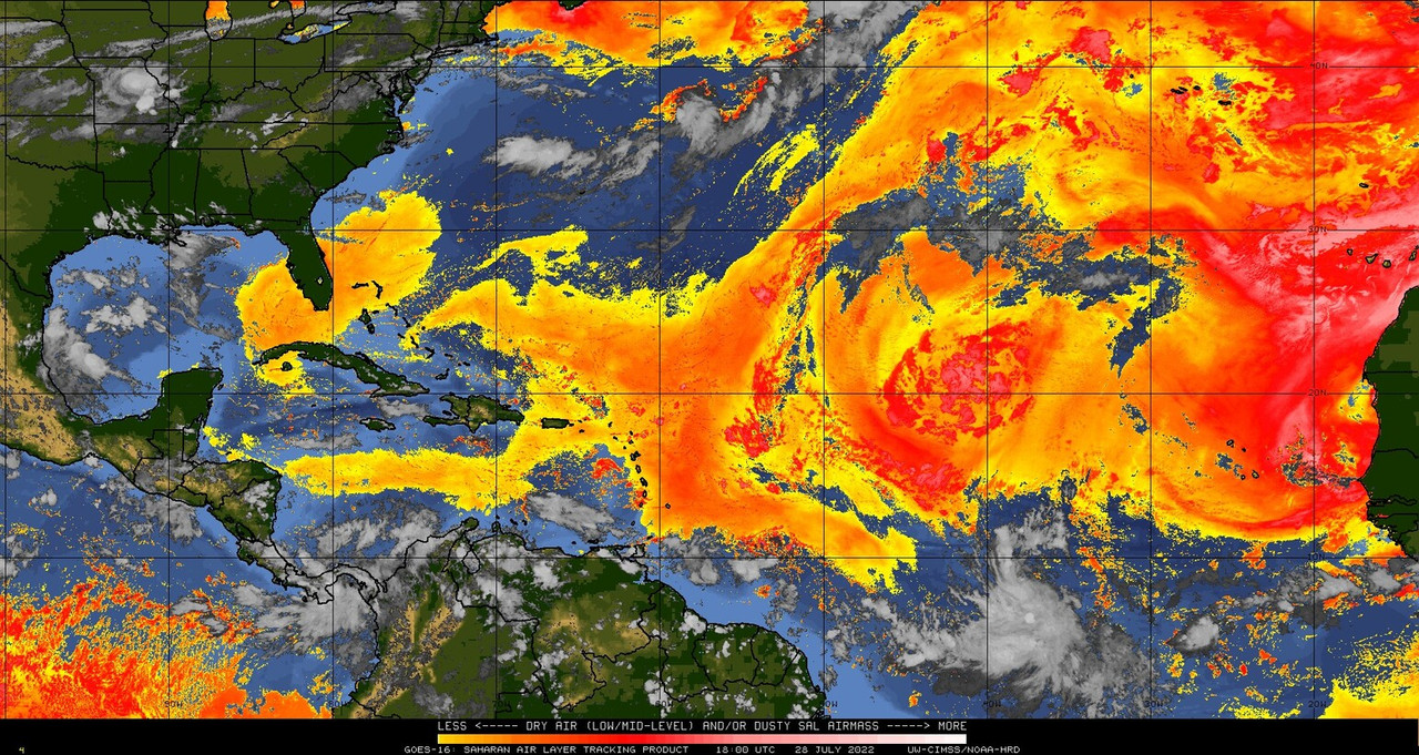
It doesn’t take a sophisticated model to know why the global models are not showing any development anytime soon. That is quite a SAL surge.  Looks like nowhere in Florida has more than a 10% rain chance today which is unusual. But it is likely not going to look like that come one month from now so enjoy the quiet time while it lasts
2 likes
-
Category5Kaiju

- Category 5

- Posts: 4331
- Joined: Thu Dec 24, 2020 12:45 pm
- Location: Seattle and Phoenix
Re: 2022 Indicators (SSTs/SAL/MSLP/Shear/Steering/Instability) and >Day 16 Models

The recent trend has been showing some pretty appreciable MDR warming, as well as the Canary Current not being as cold as it was before...this looks pretty darn favorable for activity later next month if you had to ask me, assuming it holds.
2 likes
Unless explicitly stated, all info in my posts is based on my own opinions and observations. Tropical storms and hurricanes can be extremely dangerous. Refer to an accredited weather research agency or meteorologist if you need to make serious decisions regarding an approaching storm.
-
skyline385

- Category 5
- Posts: 2728
- Age: 35
- Joined: Wed Aug 26, 2020 11:15 pm
- Location: Houston TX
Re: 2022 Indicators (SSTs/SAL/MSLP/Shear/Steering/Instability) and >Day 16 Models
Category5Kaiju wrote:
The recent trend has been showing some pretty appreciable MDR warming, as well as the Canary Current not being as cold as it was before...this looks pretty darn favorable for activity later next month if you had to ask me, assuming it holds.
Just my opinion but the scale the NOAA Coral Reef Watch uses makes it really hard to decipher between the anomalies. Here is the same from Alex’s site

4 likes
-
Category5Kaiju
- Category 5
- Posts: 4331
- Joined: Thu Dec 24, 2020 12:45 pm
- Location: Seattle and Phoenix
Re: 2022 Indicators (SSTs/SAL/MSLP/Shear/Steering/Instability) and >Day 16 Models
skyline385 wrote:Category5Kaiju wrote:https://i.imgur.com/hxQhM4S.png
The recent trend has been showing some pretty appreciable MDR warming, as well as the Canary Current not being as cold as it was before...this looks pretty darn favorable for activity later next month if you had to ask me, assuming it holds.
Just my opinion but the scale the NOAA Coral Reef Watch uses makes it really hard to decipher between the anomalies. Here is the same from Alex’s site
https://uploads.tapatalk-cdn.com/20220728/9c00971eb07ae403414cbd6c07cd91d0.jpg
Well as you can see in both versions, there is consensus that the eastern MDR has indeed warmed up pretty nicely and the W. Atlantic remains solidly warm. The subtropical cold pool is still there, but in the context of warmer than average sst anomalies in the MDR, looks like we're at least on that particular track
3 likes
Unless explicitly stated, all info in my posts is based on my own opinions and observations. Tropical storms and hurricanes can be extremely dangerous. Refer to an accredited weather research agency or meteorologist if you need to make serious decisions regarding an approaching storm.

Re: 2022 Indicators (SSTs/SAL/MSLP/Shear/Steering/Instability) and >Day 16 Models
I thought SST means nothing to some people  I guess SST is big factor only if they are warm. It is not a big factor if it's cold
5 likes

Re: 2022 Indicators (SSTs/SAL/MSLP/Shear/Steering/Instability) and >Day 16 Models
SFLcane wrote:Was not sure were to leave this article but i thought it was interesting as it speaks about current and expected condtions across the tropical atlantic from John Morales
It’s all about perception, though. We’ve had three named storms so far, where the normal by this date is two. We’ve had zero hurricanes, where the normal by this date is also zero. You read that right—the first hurricane of the Atlantic season on average shows up by August 11. From this measure, the season is pretty much behaving as a hurricane season should
Despite Perceived Slow Start, 2022 Hurricane Season Behaving Normally
https://www.nbcmiami.com/weather/hurric ... y/2822047/
Compared to a normal year, yes, but during the past 30 years most very active seasons with La Nina present July was fairly active with at least several weak tropical storms and at least a hurricane by the end of July.
Based on activity so far this year it could end up like the Nina years of 1998, 1999, 2000, 2007 & 2016 that activity didn't really get going until mid to late August. The average ACE between those years is of 136 ACE.
3 likes
-
Category5Kaiju
- Category 5
- Posts: 4331
- Joined: Thu Dec 24, 2020 12:45 pm
- Location: Seattle and Phoenix
Re: 2022 Indicators (SSTs/SAL/MSLP/Shear/Steering/Instability) and >Day 16 Models
zzh wrote:I thought SST means nothing to some people
Well, I think the way you can see it is that warm MDR sst anomalies can only help, not hurt.
0 likes
Unless explicitly stated, all info in my posts is based on my own opinions and observations. Tropical storms and hurricanes can be extremely dangerous. Refer to an accredited weather research agency or meteorologist if you need to make serious decisions regarding an approaching storm.
-
skyline385
- Category 5
- Posts: 2728
- Age: 35
- Joined: Wed Aug 26, 2020 11:15 pm
- Location: Houston TX
2022 Indicators (SSTs/SAL/MSLP/Shear/Steering/Instability) and >Day 16 Models
Todays weeklies show some activity for August end but nothing noteworthy in the precip plots. Something to keep in mind, the EURO site uses different scales for climo plot. The forecasted activity for August end is slightly higher than climo, most of the increased activity being in the Western Atlantic.


Last edited by skyline385 on Thu Jul 28, 2022 3:12 pm, edited 1 time in total.
0 likes
-
captainbarbossa19
- Professional-Met
- Posts: 1094
- Age: 27
- Joined: Wed Aug 21, 2019 11:09 pm
- Location: Beaumont, TX
Re: 2022 Indicators (SSTs/SAL/MSLP/Shear/Steering/Instability) and >Day 16 Models
skyline385 wrote:Todays weeklies show some activity for August end but nothing noteworthy in the precip plots
https://uploads.tapatalk-cdn.com/20220728/eccafac6efad786517bda06768c5ae43.jpg
https://uploads.tapatalk-cdn.com/20220728/6a5f5303f6ba1020cf07966246846de9.jpg
https://uploads.tapatalk-cdn.com/20220728/fcf8dbb03e9c2090add2f0e6dead51d4.jpg
https://uploads.tapatalk-cdn.com/20220728/2ab790ca0207b46490270814501721bf.jpg
Yep. They will start to turn around in August. We have seen models go from showing nothing one week to storm after storm the next in August.
2 likes

Re: 2022 Indicators (SSTs/SAL/MSLP/Shear/Steering/Instability) and >Day 16 Models
zzh wrote:I thought SST means nothing to some people
The point is that warmer MDR SSTAs are usually correlated with active seasons, but the lack of MDR warmth doesn't preclude one. Many years that met the hyperactive ACE threshold did not have crazy MDR SSTs, and likewise many years with warm SSTs underperformed.
MDR SSTA is a factor, but just one piece of the puzzle and not the sole factor for hyping or cancelling a season. Other factors, even those that deal with SSTs directly like the overall SSTA configuration and the tropopause, also matter.
In 2020 and 2021, when we had warmer SSTAs, people were using the subtropical warm pool to cancel the seasons. This year, when the subtropics is cool, people now cherrypick on MDR SSTs. Hmm.
2 likes
TC naming lists: retirements and intensity
Most aggressive Advisory #1's in North Atlantic (cr. kevin for starting the list)
Most aggressive Advisory #1's in North Atlantic (cr. kevin for starting the list)
-
SFLcane
- S2K Supporter
- Posts: 10281
- Age: 48
- Joined: Sat Jun 05, 2010 1:44 pm
- Location: Lake Worth Florida
Re: 2022 Indicators (SSTs/SAL/MSLP/Shear/Steering/Instability) and >Day 16 Models
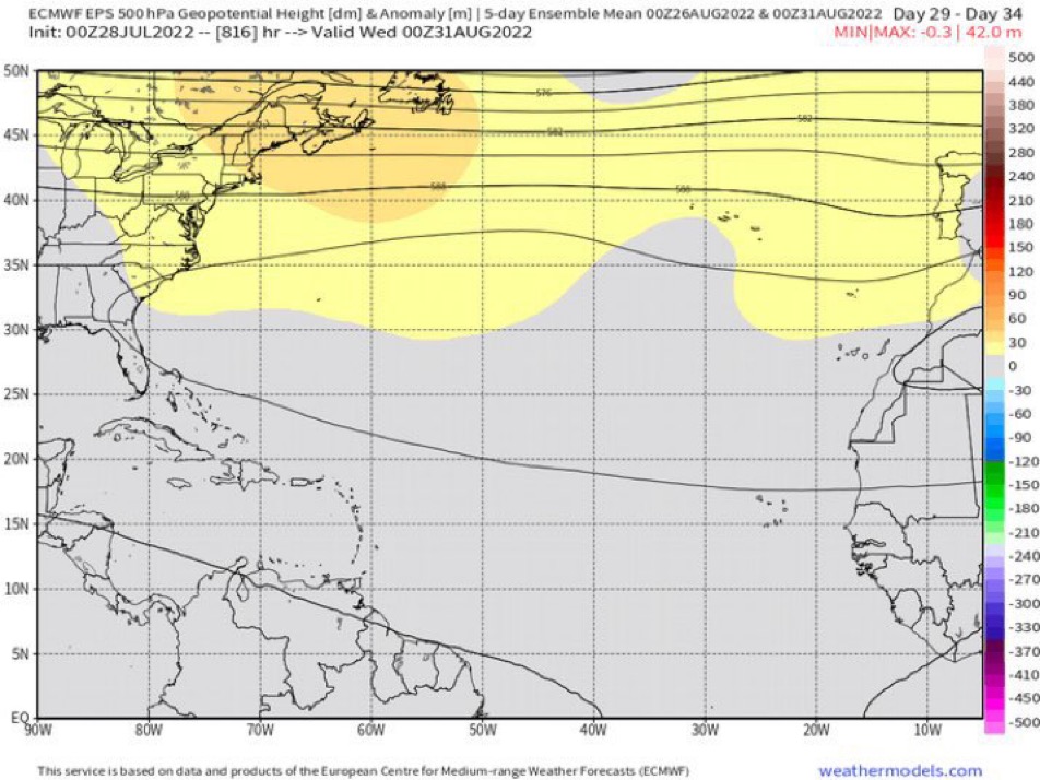
New weeklies! Signs of life surely.
1 likes

Re: 2022 Indicators (SSTs/SAL/MSLP/Shear/Steering/Instability) and >Day 16 Models
I have no idea what I'm looking at. Explanation?
0 likes
Personal Forecast Disclaimer:
The posts in this forum are NOT official forecast and should not be used as such. They are just the opinion of the poster and may or may not be backed by sound meteorological data. They are NOT endorsed by any professional institution or storm2k.org. For official information, please refer to the NHC and NWS products.
The posts in this forum are NOT official forecast and should not be used as such. They are just the opinion of the poster and may or may not be backed by sound meteorological data. They are NOT endorsed by any professional institution or storm2k.org. For official information, please refer to the NHC and NWS products.
-
Category5Kaiju
- Category 5
- Posts: 4331
- Joined: Thu Dec 24, 2020 12:45 pm
- Location: Seattle and Phoenix
Re: 2022 Indicators (SSTs/SAL/MSLP/Shear/Steering/Instability) and >Day 16 Models
SoupBone wrote:
I have no idea what I'm looking at. Explanation?
Stout east coast ridging. Meaning if anything forms in the open ocean and misses a trough, it could have a higher chance of hitting land, especially the CONUS
0 likes
Unless explicitly stated, all info in my posts is based on my own opinions and observations. Tropical storms and hurricanes can be extremely dangerous. Refer to an accredited weather research agency or meteorologist if you need to make serious decisions regarding an approaching storm.
-
SFLcane
- S2K Supporter
- Posts: 10281
- Age: 48
- Joined: Sat Jun 05, 2010 1:44 pm
- Location: Lake Worth Florida
Re: 2022 Indicators (SSTs/SAL/MSLP/Shear/Steering/Instability) and >Day 16 Models
SoupBone wrote:
I have no idea what I'm looking at. Explanation?
If it sticks which it might very well do those 500mb heights are close if not the classic look to Conus strikes.
0 likes
-
ElectricStorm

- Category 5
- Posts: 5142
- Age: 25
- Joined: Tue Aug 13, 2019 11:23 pm
- Location: Norman, OK
Re: 2022 Indicators (SSTs/SAL/MSLP/Shear/Steering/Instability) and >Day 16 Models
816 hours out
4 likes
B.S Meteorology, University of Oklahoma '25
Please refer to the NHC, NWS, or SPC for official information.
Please refer to the NHC, NWS, or SPC for official information.
Who is online
Users browsing this forum: No registered users and 58 guests