ENSO Updates (2007 thru 2023)
Moderator: S2k Moderators
Forum rules

The posts in this forum are NOT official forecasts and should not be used as such. They are just the opinion of the poster and may or may not be backed by sound meteorological data. They are NOT endorsed by any professional institution or STORM2K. For official information, please refer to products from the National Hurricane Center and National Weather Service.


Folks El Nino is here. Looking at sea surface anomalies and SOI's persistent negatives most of June and now July no doubt El Nino is here and will be declared soon if not today. If this idea stands July will be the first month in which we see the tropical regions be effected by El Nino.
0 likes
The above post and any post by Ntxw is NOT an official forecast and should not be used as such. It is just the opinion of the poster and may or may not be backed by sound meteorological data. It is NOT endorsed by any professional institution including Storm2k. For official information, please refer to NWS products.
Help support Storm2K!
-
wxman57

- Moderator-Pro Met

- Posts: 23174
- Age: 68
- Joined: Sat Jun 21, 2003 8:06 pm
- Location: Houston, TX (southwest)
Re: ENSO Updates
Actually, I believe there has to be a 3 month average (for a 5 month period?) of El Nino conditions before it is declared "official". However, its effects will be felt during peak season in August and September.
0 likes
Re: ENSO Updates
wxman57 wrote:Actually, I believe there has to be a 3 month average (for a 5 month period?) of El Nino conditions before it is declared "official". However, its effects will be felt during peak season in August and September.
90 day SOI is reflective of that trimonthly wxman. Once it approaches the -8 threshold it's not inconceivable that June/July/August will be our first Nino trimonthly.
0 likes
The above post and any post by Ntxw is NOT an official forecast and should not be used as such. It is just the opinion of the poster and may or may not be backed by sound meteorological data. It is NOT endorsed by any professional institution including Storm2k. For official information, please refer to NWS products.
Help support Storm2K!
Help support Storm2K!
-
joshb19882004
- Tropical Low

- Posts: 23
- Joined: Thu Apr 05, 2012 10:10 am
Re: ENSO Updates
the atmosphere is lagging behind right now although the el nino pattern is present noaa in todays update said that the atmosphere reflects cool to neutral
0 likes
Re: ENSO Updates
wxman57 wrote:Actually, I believe there has to be a 3 month average (for a 5 month period?) of El Nino conditions before it is declared "official". However, its effects will be felt during peak season in August and September.
That is correct..five trimonthly averages in a row of +0.5 C Nino 3.4 anomaly or warmer is the minimum for El Nino to be officially declared. Therefore, it can't be officially declared until well after it starts in retrospect. Based on the recent pretty sharp SST rises in 3.4 (now at +0.6 C) along with the persistent solid -SOI (also OHC anomalies have risen further in June vs. May), I'm educatedly guessing that JJA will, in retrospect be the start, trimonthlywise, of an official El Nino. If that turns out to be the case, it technically couldn't actually be declared until after OND is determined (at the end of the 5th trimonth), which would be ~1/1/13. Assuming that occurs, the Nino would have started in retrospect in JJA or about now. In other words, we'd in retrospect now be at about the start of El Nino assuming the +0.5+ 3.4 SST's end up persisting. In reality, we'd pretty much know with a lot of confidence well before OND. There's no sense forecastingwise in waiting until 1/1/13. We might as well now assume we're likely at about the start of El Nino, especially considering what the ENSO models are showing.
Last edited by LarryWx on Mon Jul 02, 2012 10:37 am, edited 4 times in total.
0 likes
Personal Forecast Disclaimer:
The posts in this forum are NOT official forecasts and should not be used as such. They are just the opinion of the poster and may or may not be backed by sound meteorological data. They are NOT endorsed by any professional institution or storm2k.org. For official information, please refer to the NHC and NWS products.
The posts in this forum are NOT official forecasts and should not be used as such. They are just the opinion of the poster and may or may not be backed by sound meteorological data. They are NOT endorsed by any professional institution or storm2k.org. For official information, please refer to the NHC and NWS products.
-
cycloneye

- Admin

- Posts: 149475
- Age: 69
- Joined: Thu Oct 10, 2002 10:54 am
- Location: San Juan, Puerto Rico
Re: ENSO Updates
Climate Prediction Center 7/2/12 Update/Nino 3.4 reaches El Nino threshold
This update is very important because Nino 3.4 has reached El Nino threshold of +0.5C.In fact it went up to +0.6C
http://www.cpc.ncep.noaa.gov/products/a ... ts-web.pdf

This update is very important because Nino 3.4 has reached El Nino threshold of +0.5C.In fact it went up to +0.6C
http://www.cpc.ncep.noaa.gov/products/a ... ts-web.pdf
0 likes
Visit the Caribbean-Central America Weather Thread where you can find at first post web cams,radars
and observations from Caribbean basin members Click Here
and observations from Caribbean basin members Click Here
-
euro6208
Re: CPC Update/Nino 3.4 reaches El Nino threshold/up to +0.6C
mmm the mjo is expected to return to the western hemisphere combined with high pressure over australia (more tanking of soi), looks like this el nino might be a strong one...
0 likes
-
joshb19882004
- Tropical Low
- Posts: 23
- Joined: Thu Apr 05, 2012 10:10 am
Re: CPC Update/Nino 3.4 reaches El Nino threshold/up to +0.6C
could it be possible for el nino to get strong with a cold pdo in a short amount of time
0 likes

Re: ENSO Updates
wxman57 wrote:Actually, I believe there has to be a 3 month average (for a 5 month period?) of El Nino conditions before it is declared "official". However, its effects will be felt during peak season in August and September.
Yeah, we'll probably be in the 'moderate' range by September, think it may well be an early ending season.
0 likes
Personal Forecast Disclaimer:
The posts in this forum are NOT official forecast and should not be used as such. They are just the opinion of the poster and may or may not be backed by sound meteorological data. They are NOT endorsed by any professional institution or storm2k.org. For official information, please refer to the NHC and NWS products
The posts in this forum are NOT official forecast and should not be used as such. They are just the opinion of the poster and may or may not be backed by sound meteorological data. They are NOT endorsed by any professional institution or storm2k.org. For official information, please refer to the NHC and NWS products
-
Blown Away

- S2K Supporter

- Posts: 10253
- Joined: Wed May 26, 2004 6:17 am
Re: CPC Update/Nino 3.4 reaches El Nino threshold/up to +0.6C
Does this years pattern resemble an El Nino year of the past?
0 likes
Hurricane Eye Experience: David 79, Irene 99, Frances 04, Jeanne 04, Wilma 05… Hurricane Brush Experience: Andrew 92, Erin 95, Floyd 99, Matthew 16, Irma 17, Ian 22, Nicole 22…
-
cycloneye
- Admin
- Posts: 149475
- Age: 69
- Joined: Thu Oct 10, 2002 10:54 am
- Location: San Juan, Puerto Rico
Re: CPC Update/Nino 3.4 reaches El Nino threshold/up to +0.6C
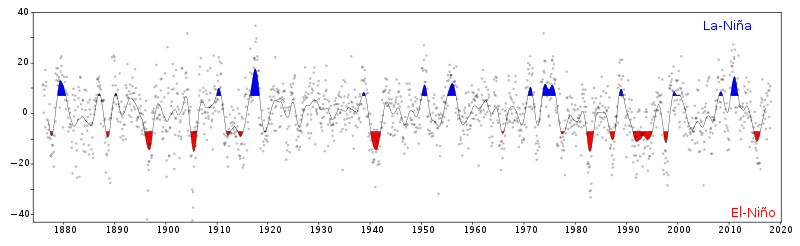
Here is how the 30 day SOI has behaved since 1800 to present. The big question is how strong this El Nino will be.
0 likes
Visit the Caribbean-Central America Weather Thread where you can find at first post web cams,radars
and observations from Caribbean basin members Click Here
and observations from Caribbean basin members Click Here
Re: CPC Update/Nino 3.4 reaches El Nino threshold/up to +0.6C
Blown Away wrote:Does this years pattern resemble an El Nino year of the past?
Not in terms of named systems or much in the way of tropics (though majority of NATL basin has been dominated by subtropical systems in nature), but overall global patterns and enso evolution 2002 is becoming one of the heavy weights.
0 likes
The above post and any post by Ntxw is NOT an official forecast and should not be used as such. It is just the opinion of the poster and may or may not be backed by sound meteorological data. It is NOT endorsed by any professional institution including Storm2k. For official information, please refer to NWS products.
Help support Storm2K!
Help support Storm2K!


Re:
NDG wrote:Weird that today's graphic update shows a slight cool down at Nino 3.4 Region from a week ago.
Nino 4 held steady maybe even slightly cool but 3 rose significantly which is what brought 3.4 over. 3.4 is a composite of 3 and 4 regions with 3 having a larger chunk
0 likes
The above post and any post by Ntxw is NOT an official forecast and should not be used as such. It is just the opinion of the poster and may or may not be backed by sound meteorological data. It is NOT endorsed by any professional institution including Storm2k. For official information, please refer to NWS products.
Help support Storm2K!
Help support Storm2K!
-
hurricanetrack

- HurricaneTrack.com

- Posts: 1781
- Joined: Tue Dec 02, 2003 10:46 pm
- Location: Wilmington, NC
- Contact:
Re:
hurricanetrack wrote:Weak to mod El Nino against a cold PDO. Will be interesting to what THAT outcome is. Also, ATL not too shabby in deep tropics. Certainly not significantly cooler than normal and the tropical waves seem to be doing just fine for this time of year.
And to add to that a persistent neutral to negative NAO over the last couple of months, maybe the reason why the atmosphere is still lagging behind with similarities to a cool to neutral ENSO.
0 likes
Re:
NDG wrote:Weird that today's graphic update shows a slight cool down at Nino 3.4 Region from a week ago.
In addition to what was stated about the eastern 3.4 warming while the western 3.4 may have cooled, you're comparing 7/2 with 6/25. During that time, it does look as if the western 3.4 cooled although eastern 3.4 looks to have warmed (i.e., maybe about a wash). In reality, however, the weekly Nino SST releases are based on the average for the prior calendar week. So, today's release is actually based on the average of 6/24-30. The prior release, that from 6/25, is actually based on the average of 6/17-23. So, the proper comparison would be the avg. of 6/24-30 vs. the avg. of 6/17-23. If those two averages were compared, it may very well be that 6/24-30 would clearly look warmer than 6/17-23 in Nino 3.4.
0 likes
Personal Forecast Disclaimer:
The posts in this forum are NOT official forecasts and should not be used as such. They are just the opinion of the poster and may or may not be backed by sound meteorological data. They are NOT endorsed by any professional institution or storm2k.org. For official information, please refer to the NHC and NWS products.
The posts in this forum are NOT official forecasts and should not be used as such. They are just the opinion of the poster and may or may not be backed by sound meteorological data. They are NOT endorsed by any professional institution or storm2k.org. For official information, please refer to the NHC and NWS products.
-
joshb19882004
- Tropical Low
- Posts: 23
- Joined: Thu Apr 05, 2012 10:10 am
Re: CPC Update/Nino 3.4 reaches El Nino threshold/up to +0.6C
the neutral to -nao maybe also responsable for the massive heat wave over the central and eastern sections of the U.S
0 likes

Re: CPC Update/Nino 3.4 reaches El Nino threshold/up to +0.6C
Blown Away wrote:Does this years pattern resemble an El Nino year of the past?
Currently the pattern from January thru May in Nino 3-4 most closely resembles 1951 , 2006 , and 2009
0 likes
-
Kingarabian

- S2K Supporter
- Posts: 16364
- Joined: Sat Aug 08, 2009 3:06 am
- Location: Honolulu, Hawaii
Re: CPC Update/Nino 3.4 reaches El Nino threshold/up to +0.6C
hcane27 wrote:Blown Away wrote:Does this years pattern resemble an El Nino year of the past?
Currently the pattern from January thru May in Nino 3-4 most closely resembles 1951 , 2006 , and 2009
Not so sure about 2009.
2009's El-Nino was really strong and it suppressed all activity in the Atlantic basin.
0 likes
RIP Kobe Bryant
Who is online
Users browsing this forum: Iceresistance and 220 guests