

Central Atlantic / Eastern Atlantic
Moderator: S2k Moderators
Forum rules

The posts in this forum are NOT official forecasts and should not be used as such. They are just the opinion of the poster and may or may not be backed by sound meteorological data. They are NOT endorsed by any professional institution or STORM2K. For official information, please refer to products from the National Hurricane Center and National Weather Service.

-
Gustywind

- Category 5

- Posts: 12334
- Joined: Mon Sep 03, 2007 7:29 am
- Location: Baie-Mahault, GUADELOUPE
000
AXNT20 KNHC 051819
TWDAT
TROPICAL WEATHER DISCUSSION
NWS TPC/NATIONAL HURRICANE CENTER MIAMI FL
205 PM EDT THU JUN 05 2008
TROPICAL WEATHER DISCUSSION FOR NORTH AMERICA...CENTRAL
AMERICA...GULF OF MEXICO...CARIBBEAN SEA...NORTHERN SECTIONS OF
SOUTH AMERICA...AND ATLANTIC OCEAN TO THE AFRICAN COAST FROM THE
EQUATOR TO 32N. THE FOLLOWING INFORMATION IS BASED ON SATELLITE
IMAGERY...METEOROLOGICAL ANALYSIS...WEATHER OBSERVATIONS...AND
RADAR.
BASED ON 1200 UTC SURFACE ANALYSIS AND SATELLITE IMAGERY THROUGH
1715 UTC.
...TROPICAL WAVES...
TROPICAL WAVE IS INTRODUCED ALONG 23W S OF 16N MOVING W 15 KT.
SOUNDING DATA FROM DAKAR STILL REVEALS A STRONG RISE/FALL
COUPLET IN SEVERAL DIFFERENT FIELDS...WITH THE MOST NOTABLE
BEING 2-3 MB PRESSURE RISES TODAY IN THE WAKE OF THIS FEATURE.
MIMIC-TPW ANIMATION ALSO SHOWS A NEW SURGE OF DEEP MOISTURE
RISING TO 15N ALONG 20W IN ASSOCIATION WITH THIS WAVE....AND THE
LATEST SFC ANALYSIS SHOWS A NORTHWARD RISE IN THE ITCZ. ALTHOUGH
RECENT METEOSAT IMAGERY IS UNAVAILABLE...MORNING IMAGES DID
INDICATE SCATTERED TO WIDESPREAD CONVECTION FROM 04N TO 09N
BETWEEN 21W AND 28W...IN AN UNUSUAL LOCATION W OF THE AXIS.
Waouw that's remind me more the end of July when you read that..but as something classical right now ...at least one decent wave per weather forecast :eek.. i don't know how many waves have crossed the atlantic ocean, but something is sure they are getting bigger and bigger weeks after weeks

AXNT20 KNHC 051819
TWDAT
TROPICAL WEATHER DISCUSSION
NWS TPC/NATIONAL HURRICANE CENTER MIAMI FL
205 PM EDT THU JUN 05 2008
TROPICAL WEATHER DISCUSSION FOR NORTH AMERICA...CENTRAL
AMERICA...GULF OF MEXICO...CARIBBEAN SEA...NORTHERN SECTIONS OF
SOUTH AMERICA...AND ATLANTIC OCEAN TO THE AFRICAN COAST FROM THE
EQUATOR TO 32N. THE FOLLOWING INFORMATION IS BASED ON SATELLITE
IMAGERY...METEOROLOGICAL ANALYSIS...WEATHER OBSERVATIONS...AND
RADAR.
BASED ON 1200 UTC SURFACE ANALYSIS AND SATELLITE IMAGERY THROUGH
1715 UTC.
...TROPICAL WAVES...
TROPICAL WAVE IS INTRODUCED ALONG 23W S OF 16N MOVING W 15 KT.
SOUNDING DATA FROM DAKAR STILL REVEALS A STRONG RISE/FALL
COUPLET IN SEVERAL DIFFERENT FIELDS...WITH THE MOST NOTABLE
BEING 2-3 MB PRESSURE RISES TODAY IN THE WAKE OF THIS FEATURE.
MIMIC-TPW ANIMATION ALSO SHOWS A NEW SURGE OF DEEP MOISTURE
RISING TO 15N ALONG 20W IN ASSOCIATION WITH THIS WAVE....AND THE
LATEST SFC ANALYSIS SHOWS A NORTHWARD RISE IN THE ITCZ. ALTHOUGH
RECENT METEOSAT IMAGERY IS UNAVAILABLE...MORNING IMAGES DID
INDICATE SCATTERED TO WIDESPREAD CONVECTION FROM 04N TO 09N
BETWEEN 21W AND 28W...IN AN UNUSUAL LOCATION W OF THE AXIS.
Waouw that's remind me more the end of July when you read that..but as something classical right now ...at least one decent wave per weather forecast
0 likes


Re: Central Atlantic / Coast of Africa
We could be journying into another historic season.Not quite like 2005,but I have a feeling we will cpme close to a record or two as far as early hurricane formations
0 likes
-
Evil Jeremy

- S2K Supporter

- Posts: 5463
- Age: 32
- Joined: Mon Apr 10, 2006 2:10 pm
- Location: Los Angeles, CA
Re: Central Atlantic / Coast of Africa
Convection dieing out tonight. This really needs to move north within the next 24 hours for it to even have chance.
0 likes
-
Gustywind
- Category 5
- Posts: 12334
- Joined: Mon Sep 03, 2007 7:29 am
- Location: Baie-Mahault, GUADELOUPE
Re: Central Atlantic / Coast of Africa
canegrl04 wrote:We could be journying into another historic season.Not quite like 2005,but I have a feeling we will cpme close to a record or two as far as early hurricane formations
Absolulety interresting
0 likes
-
Gustywind
- Category 5
- Posts: 12334
- Joined: Mon Sep 03, 2007 7:29 am
- Location: Baie-Mahault, GUADELOUPE
000
AXNT20 KNHC 052333
TWDAT
TROPICAL WEATHER DISCUSSION
NWS TPC/NATIONAL HURRICANE CENTER MIAMI FL
805 PM EDT THU JUN 05 2008
TROPICAL WEATHER DISCUSSION FOR NORTH AMERICA...CENTRAL
AMERICA...GULF OF MEXICO...CARIBBEAN SEA...NORTHERN SECTIONS OF
SOUTH AMERICA...AND ATLANTIC OCEAN TO THE AFRICAN COAST FROM THE
EQUATOR TO 32N. THE FOLLOWING INFORMATION IS BASED ON SATELLITE
IMAGERY...METEOROLOGICAL ANALYSIS...WEATHER OBSERVATIONS...AND
RADAR.
BASED ON 1800 UTC SURFACE ANALYSIS AND SATELLITE IMAGERY THROUGH
2315 UTC.
...TROPICAL WAVES...
TROPICAL WAVE IS ALONG 22W/23W S OF 15W MOVING W NEAR 10-15 KT.
WAVE PRESENTATION ON MIMIC-TPW IS VERY GOOD WITH A BROAD AREA OF
DEEP MOISTURE EXTENDING E TO THE COAST OF AFRICA. HOWEVER...THE
SATELLITE IMAGERY SHOWERS NO SHOWERS OR DEEP CONVECTION.
TROPICAL WAVE IS ALONG 50W/51W S OF 20N IS MOVING W NEAR 20 KT.
WAVE PRESENTATION ON MIMIC-TPW IS VERY GOOD WITH A SMALL LOW
LEVEL LOW ALONG THE WAVE NEAR 10N VISIBLE ON SATELLITE IMAGERY.
CLUSTERS OF SCATTERED MODERATE CONVECTION ARE FROM 8N-11N
BETWEEN 46W-52W.
0 likes

Re: Central Atlantic / Coast of Africa
Latest TWD
TROPICAL WAVE IS ALONG 26W/27W S OF 14W MOVING W NEAR 15-20 KT.
PRESENTATION ON MIMIC-TPW ANIMATION SHOWS WAVE AMPLITUDE N TO
JUST SW OF THE CAPE VERDE ISLANDS WITH A BROAD AREA OF DEEP
MOISTURE EXTENDING E TO THE COAST OF AFRICA. HOWEVER...
SATELLITE IMAGERY SHOWS NO DEEP CONVECTION WITH ONLY SCATTERED
SHOWERS IN THE VICINITY AND ANY CONVECTION IS MOSTLY LIKELY
EMBEDDED WITHIN THE ITCZ.
TROPICAL WAVE IS ALONG 54W S OF 20N IS MOVING W NEAR 20 KT.
SCATTERED MODERATE CONVECTION ASSOCIATED WITH MIDDLE TO LOW
LEVEL CYCLONIC CURVATURE IS FROM 9N-12N BETWEEN 50-57W.
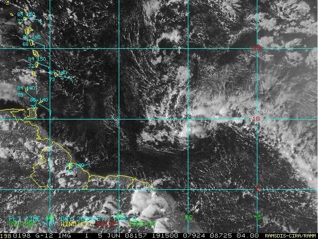
The wave @ 55W flaring up again this morning. A little twist to the clouds but visible loop shows it mostly mid level.
TROPICAL WAVE IS ALONG 26W/27W S OF 14W MOVING W NEAR 15-20 KT.
PRESENTATION ON MIMIC-TPW ANIMATION SHOWS WAVE AMPLITUDE N TO
JUST SW OF THE CAPE VERDE ISLANDS WITH A BROAD AREA OF DEEP
MOISTURE EXTENDING E TO THE COAST OF AFRICA. HOWEVER...
SATELLITE IMAGERY SHOWS NO DEEP CONVECTION WITH ONLY SCATTERED
SHOWERS IN THE VICINITY AND ANY CONVECTION IS MOSTLY LIKELY
EMBEDDED WITHIN THE ITCZ.
TROPICAL WAVE IS ALONG 54W S OF 20N IS MOVING W NEAR 20 KT.
SCATTERED MODERATE CONVECTION ASSOCIATED WITH MIDDLE TO LOW
LEVEL CYCLONIC CURVATURE IS FROM 9N-12N BETWEEN 50-57W.
The wave @ 55W flaring up again this morning. A little twist to the clouds but visible loop shows it mostly mid level.
0 likes


Re: Central Atlantic / Coast of Africa
Convection has increased but it doesn't have much water left before it hits South America.
0 likes
-
DESTRUCTION5

- Category 5
- Posts: 4430
- Age: 44
- Joined: Wed Sep 03, 2003 11:25 am
- Location: Stuart, FL


Re: Central Atlantic / Coast of Africa
Hey if can get N of 11N, it will hit an upper ridge in about 12 hours near the islands...then it finds the TUTT
0 likes


-
gatorcane

- S2K Supporter
- Posts: 23708
- Age: 48
- Joined: Sun Mar 13, 2005 3:54 pm
- Location: Boca Raton, FL
Re: Central Atlantic / Coast of Africa
It looks like its trying to nudge a little bit more W to WNW although it needs to pull up or it is going to hit SA.
Note TAFB surface analysis indicates the wave axis is going to pass right through the Caribbean so we can monitor it over the next several days.

Note TAFB surface analysis indicates the wave axis is going to pass right through the Caribbean so we can monitor it over the next several days.
0 likes
A very interesting wave indeed, got some nice convection there for early June esp that far west into the Atlantic where alot of waves go poof, though the southerly nature of this wave has probably helped to keep this system closer to the warmer waters.
If it can keep convection and the northern part of the wave axis keeps over the water then we will indeed need to watch the wave very closely in the Caribbean sea.
If it can keep convection and the northern part of the wave axis keeps over the water then we will indeed need to watch the wave very closely in the Caribbean sea.
0 likes

Who is online
Users browsing this forum: Google [Bot], Yellow Evan and 282 guests