
Top hurricane sat photos of all time...
Moderator: S2k Moderators
Forum rules

The posts in this forum are NOT official forecasts and should not be used as such. They are just the opinion of the poster and may or may not be backed by sound meteorological data. They are NOT endorsed by any professional institution or STORM2K. For official information, please refer to products from the National Hurricane Center and National Weather Service.
-
euro6208
Re: Top hurricane sat photos of all time...
Only TC thus far >35 knots in the WPAC...Cat 5 monster...Nepartak...
0 likes

Re: Top hurricane sat photos of all time...
On a more recent note, here's a stunning image of Hurricane Blas as a cat 4, in the Eastern Pacific. Resembles Igor in a way... 

0 likes
Igor 2010, Sandy 2012, Fay 2014, Gonzalo 2014, Joaquin 2015, Nicole 2016, Humberto 2019, Imelda 2025
I am only a tropical weather enthusiast. My predictions are not official and may or may not be backed by sound meteorological data. For official information, please refer to the NHC and NWS products.
I am only a tropical weather enthusiast. My predictions are not official and may or may not be backed by sound meteorological data. For official information, please refer to the NHC and NWS products.
-
hurricanes1234
- Category 5

- Posts: 2908
- Joined: Sat Jul 28, 2012 6:19 pm
- Location: Trinidad and Tobago
Re: Top hurricane sat photos of all time...
0 likes
PLEASE NOTE: With the exception of information from weather agencies that I may copy and paste here, my posts will NEVER be official, since I am NOT a meteorologist. They are solely my amateur opinion, and may or may not be accurate. Therefore, please DO NOT use them as official details, particularly when making important decisions. Thank you.
-
StormChaser75

- Tropical Storm

- Posts: 101
- Age: 24
- Joined: Sat Feb 06, 2016 4:23 pm
- Location: Corpus Christi TX
- Contact:
Re: Top hurricane sat photos of all time...
Just thought I'll add these images of twin cat 5 typhoons ivan (on the left ) and Joan (on the right) both had a peak of 185 mph and 905 mb
 visible image,
 infrared image
Also some satelite imagery of 3 typhoons in the west Pacific in September 1987, I believe all 3 were at least of cat 3 typhoon strength at the time of the satellite imagery, ( please correct me if I'm wrong )
Typhoon Gerald on the left , typhoon Freda in the middle, and typhoon Holly on the right.


visible image, infrared image Also some satelite imagery of 3 typhoons in the west Pacific in September 1987, I believe all 3 were at least of cat 3 typhoon strength at the time of the satellite imagery, ( please correct me if I'm wrong )
Typhoon Gerald on the left , typhoon Freda in the middle, and typhoon Holly on the right.
0 likes
-
euro6208
Re: Top hurricane sat photos of all time...
StormChaser75 wrote:Just thought I'll add these images of twin cat 5 typhoons ivan (on the left ) and Joan (on the right) both had a peak of 185 mph and 905 mb
Also some satelite imagery of 3 typhoons in the west Pacific in September 1987, I believe all 3 were at least of cat 3 typhoon strength at the time of the satellite imagery, ( please correct me if I'm wrong )
Typhoon Gerald on the left , typhoon Freda in the middle, and typhoon Holly on the right.
Strongest pair of cyclones worldwide simultaneously never ceases to amaze me. Too bad no recon to investigate.
Correct...Gerald was a Cat 3, Freda a Cat 3 but shortly became a Cat 4, and Holly was a Cat 4 on it's way to a Cat 5 shortly after...
0 likes
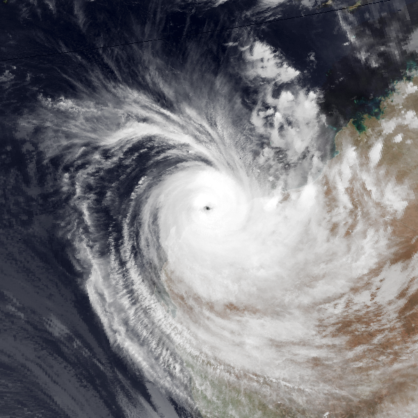
Re: Top hurricane sat photos of all time...
Cyclone Olivia near West Australia in 1996. She had amazing wispy bands- really looked like a vortex of death.
0 likes
Igor 2010, Sandy 2012, Fay 2014, Gonzalo 2014, Joaquin 2015, Nicole 2016, Humberto 2019, Imelda 2025
I am only a tropical weather enthusiast. My predictions are not official and may or may not be backed by sound meteorological data. For official information, please refer to the NHC and NWS products.
I am only a tropical weather enthusiast. My predictions are not official and may or may not be backed by sound meteorological data. For official information, please refer to the NHC and NWS products.
-
StormChaser75
- Tropical Storm
- Posts: 101
- Age: 24
- Joined: Sat Feb 06, 2016 4:23 pm
- Location: Corpus Christi TX
- Contact:
Re: Top hurricane sat photos of all time...
Hurricane Gilbert (1988)

I just love this color image of typhoon gay (1992) at around peak

Hurricane andrew (1992)


Hurricane Allen (1980)


I just love this color image of typhoon gay (1992) at around peak
Hurricane andrew (1992)
Hurricane Allen (1980)
Last edited by StormChaser75 on Tue Oct 11, 2016 5:11 pm, edited 1 time in total.
0 likes
-
euro6208
Re: Top hurricane sat photos of all time...
Gay never eases to amaze. Big circulation with fanning outflows. No wonder why it's considered one of the top typhoons that could be stronger than obsolete TIP. Highest dvorak for Gay was an amazing 8.7. I wonder what recon would have found as dvorak is low biased in these monsters. 
Last edited by euro6208 on Tue Oct 11, 2016 5:45 pm, edited 2 times in total.
0 likes
-
StormChaser75
- Tropical Storm
- Posts: 101
- Age: 24
- Joined: Sat Feb 06, 2016 4:23 pm
- Location: Corpus Christi TX
- Contact:
Re: Top hurricane sat photos of all time...
More amazing images of typhoon gay from 1992, very beautiful looking typhoon.


1 likes

Re: Top hurricane sat photos of all time...
Hurricane Matthew 2016...possibly the creepiest hurricane of all time! Thought I'd post this as we near Halloween.
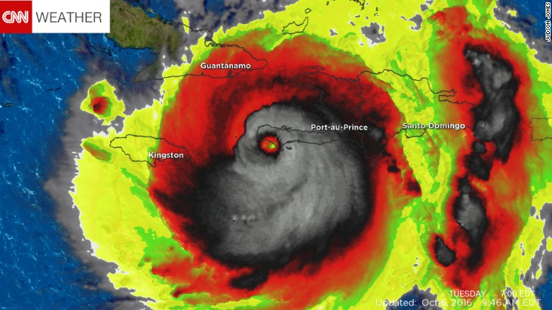
This was a one of a kind hurricane, and he was as dreadful as he looked on Satellite that morning he struck Haiti. Unbelievable how a category 4-5 landfalling cane could resemble an evil skull.
This was a one of a kind hurricane, and he was as dreadful as he looked on Satellite that morning he struck Haiti. Unbelievable how a category 4-5 landfalling cane could resemble an evil skull.
2 likes
Georges '98, Irene '99, Frances '04, Jeanne '04, Katrina '05, Wilma '05, Gustav '08, Isaac '12, Matthew '16, Florence '18, Michael '18, Ian '22
-
euro6208
Re: Top hurricane sat photos of all time...
I loved this thread.
Anymore great recent photos?
Anymore great recent photos?
0 likes
-
Vince_and_Grace_fan

- Category 1

- Posts: 328
- Joined: Thu Nov 03, 2016 9:25 am
- Location: Szombathely (Hungary)
Re: Top hurricane sat photos of all time...
Not spectacular hurricanes, but I have some funny pictures from the last season.
The 'Grumpy Pacific Ocean' (Madeline, Lester and the ITCZ):

TS Karl as a headphone:

A question mark (Gaston and a frontal zone):

The 'Grumpy Pacific Ocean' (Madeline, Lester and the ITCZ):
TS Karl as a headphone:
A question mark (Gaston and a frontal zone):
3 likes
-
tatertawt24
- Category 1
- Posts: 309
- Joined: Wed Oct 24, 2012 12:57 pm
Re: Top hurricane sat photos of all time...
Found this cool picture of one that I'd never heard of before; Cyclone Dora from 2007.

It's basically all eye.
It's basically all eye.
1 likes
Personal Forecast Disclaimer:
The posts in this forum are NOT official forecast and should not be used as such. They are just the opinion of the poster and may or may not be backed by sound meteorological data. They are NOT endorsed by any professional institution or storm2k.org. For official information, please refer to the NHC and NWS products.
The posts in this forum are NOT official forecast and should not be used as such. They are just the opinion of the poster and may or may not be backed by sound meteorological data. They are NOT endorsed by any professional institution or storm2k.org. For official information, please refer to the NHC and NWS products.
-
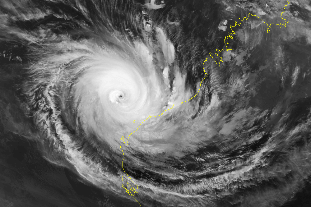
euro6208
Re: Top hurricane sat photos of all time...
Cyclone Enawo Cat 4

Cyclone Ernie Cat 4 both from the South Indian Ocean.

Cyclone Ernie Cat 4 both from the South Indian Ocean.
1 likes
-
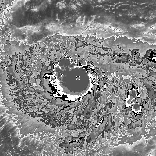
tatertawt24
- Category 1
- Posts: 309
- Joined: Wed Oct 24, 2012 12:57 pm
Re: Top hurricane sat photos of all time...

Phanfone's tiny eye.
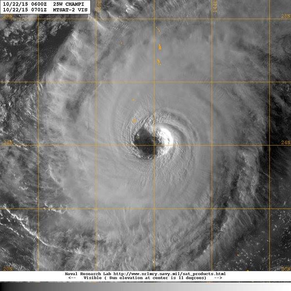
And Champi's gigantic eye.
0 likes
Personal Forecast Disclaimer:
The posts in this forum are NOT official forecast and should not be used as such. They are just the opinion of the poster and may or may not be backed by sound meteorological data. They are NOT endorsed by any professional institution or storm2k.org. For official information, please refer to the NHC and NWS products.
The posts in this forum are NOT official forecast and should not be used as such. They are just the opinion of the poster and may or may not be backed by sound meteorological data. They are NOT endorsed by any professional institution or storm2k.org. For official information, please refer to the NHC and NWS products.
-
euro6208
Re: Top hurricane sat photos of all time...
tatertawt24 wrote:
Phanfone's tiny eye.
And Champi's gigantic eye.
Too bad the WPAC doesn't have anymore recon or else.
0 likes

-
p1nheadlarry

- Category 2

- Posts: 672
- Age: 34
- Joined: Wed Jan 29, 2014 2:42 pm
- Location: SR County FL
Re: Best looking hurricane sat photo of all time...
Gotta go with Hugo or the oft-mentioned Isabel with the pinwheel in the eye.
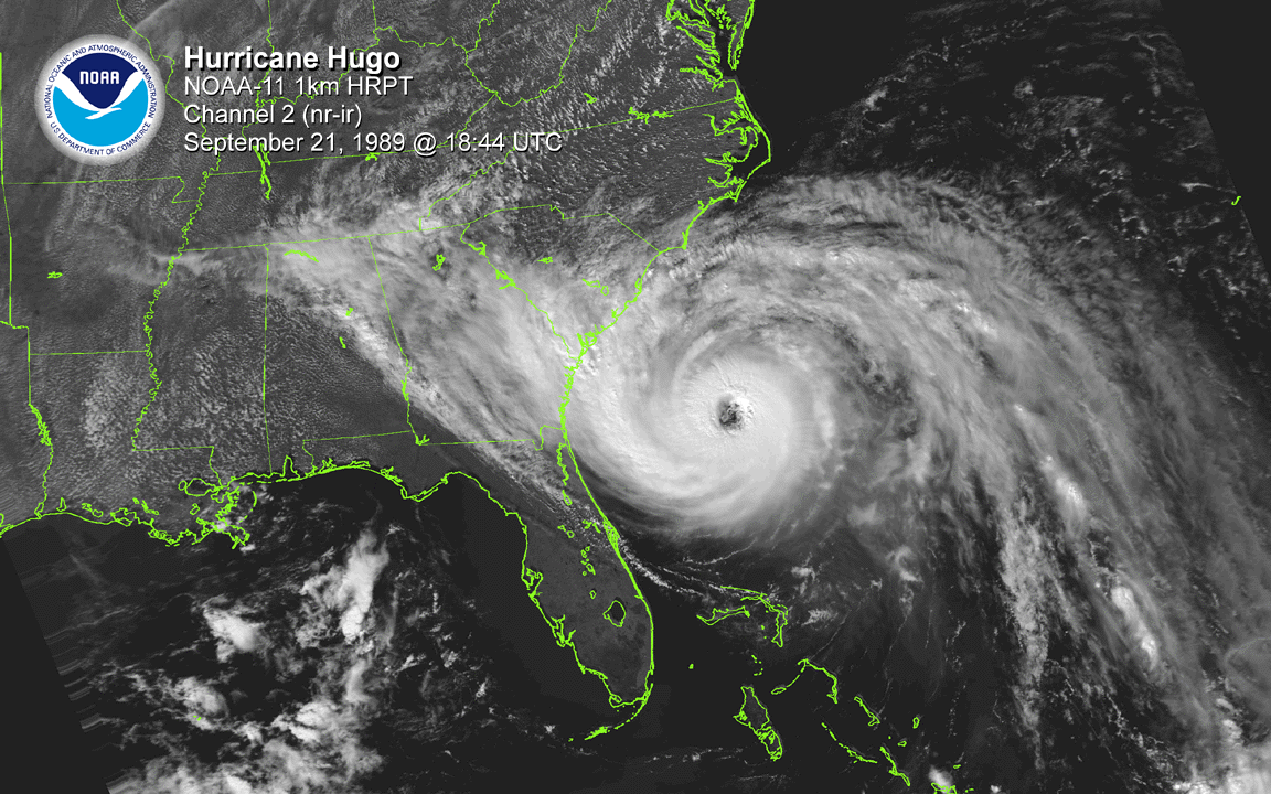
If I'm not mistaken, that's the last radar shot from Coral Gables/Miami (forget which city it was) before it failed.
Texas Snowman wrote:Not a sat shot, but just as impressive: Andrew's radar shot just after landfall...
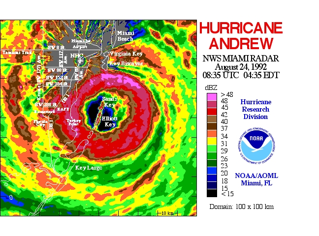
If I'm not mistaken, that's the last radar shot from Coral Gables/Miami (forget which city it was) before it failed.
0 likes
--;->#GoNoles--;->.
-
tatertawt24
- Category 1
- Posts: 309
- Joined: Wed Oct 24, 2012 12:57 pm
Re: Top hurricane sat photos of all time...
Just realized I've had these pictures bookmarked forever and never posted them.


1 likes
Personal Forecast Disclaimer:
The posts in this forum are NOT official forecast and should not be used as such. They are just the opinion of the poster and may or may not be backed by sound meteorological data. They are NOT endorsed by any professional institution or storm2k.org. For official information, please refer to the NHC and NWS products.
The posts in this forum are NOT official forecast and should not be used as such. They are just the opinion of the poster and may or may not be backed by sound meteorological data. They are NOT endorsed by any professional institution or storm2k.org. For official information, please refer to the NHC and NWS products.
-
tatertawt24
- Category 1
- Posts: 309
- Joined: Wed Oct 24, 2012 12:57 pm
Re: Top hurricane sat photos of all time...
Literally just an eye and an eyewall.
5 likes
Personal Forecast Disclaimer:
The posts in this forum are NOT official forecast and should not be used as such. They are just the opinion of the poster and may or may not be backed by sound meteorological data. They are NOT endorsed by any professional institution or storm2k.org. For official information, please refer to the NHC and NWS products.
The posts in this forum are NOT official forecast and should not be used as such. They are just the opinion of the poster and may or may not be backed by sound meteorological data. They are NOT endorsed by any professional institution or storm2k.org. For official information, please refer to the NHC and NWS products.
Who is online
Users browsing this forum: Yellow Evan and 158 guests