It's not loading for me for some reason, what is it?
2022 Indicators (SSTs/SAL/MSLP/Shear/Steering/Instability) and >Day 16 Models
Moderator: S2k Moderators
Forum rules

The posts in this forum are NOT official forecasts and should not be used as such. They are just the opinion of the poster and may or may not be backed by sound meteorological data. They are NOT endorsed by any professional institution or STORM2K. For official information, please refer to products from the National Hurricane Center and National Weather Service.
-
AutoPenalti
- Category 5

- Posts: 4091
- Age: 29
- Joined: Mon Aug 17, 2015 4:16 pm
- Location: Ft. Lauderdale, Florida
Re: 2022 indicators: SSTs / SAL / MSLP / shear / steering / instability / images
It's not loading for me for some reason, what is it?
0 likes
The posts in this forum are NOT official forecasts and should not be used as such. They are just the opinion of the poster and may or may not be backed by sound meteorological data. They are NOT endorsed by any professional institution or STORM2K. For official information, please refer to products from the NHC and NWS.
Model Runs Cheat Sheet:
GFS (5:30 AM/PM, 11:30 AM/PM)
HWRF, GFDL, UKMET, NAVGEM (6:30-8:00 AM/PM, 12:30-2:00 AM/PM)
ECMWF (1:45 AM/PM)
TCVN is a weighted averaged
-
Iceresistance

- Category 5
- Posts: 9605
- Age: 22
- Joined: Sat Oct 10, 2020 9:45 am
- Location: Tecumseh, OK/Norman, OK
Re: 2022 indicators: SSTs / SAL / MSLP / shear / steering / instability / images
AutoPenalti wrote:
It's not loading for me for some reason, what is it?
SST Anomalies forecast, I have a picture that you might see. (Unless that too can't be seen on your screen.

https://s7.gifyu.com/images/SST-Anomalies.png
0 likes
Bill 2015 & Beta 2020
Winter 2020-2021
All observations are in Tecumseh, OK unless otherwise noted.
Winter posts are focused mainly for Oklahoma & Texas.
Take any of my forecasts with a grain of salt, refer to the NWS, SPC, and NHC for official information
Never say Never with weather! Because ANYTHING is possible!
Winter 2020-2021
All observations are in Tecumseh, OK unless otherwise noted.
Winter posts are focused mainly for Oklahoma & Texas.
Take any of my forecasts with a grain of salt, refer to the NWS, SPC, and NHC for official information
Never say Never with weather! Because ANYTHING is possible!
-
DorkyMcDorkface

- Category 5
- Posts: 1039
- Age: 28
- Joined: Mon Sep 30, 2019 1:32 pm
- Location: Mid-Atlantic
Re: 2022 indicators: SSTs / SAL / MSLP / shear / steering / instability / images
Iceresistance wrote:AutoPenalti wrote:
It's not loading for me for some reason, what is it?
SST Anomalies forecast, I have a picture that you might see. (Unless that too can't be seen on your screen.)
https://s7.gifyu.com/images/SST-Anomalies.png
https://s7.gifyu.com/images/SST-Anomalies.png
Actually it's a hovmoller for 850mb winds, although there is a correlation with SSTs. Looks like the GFS is forecasting relaxed trades in the MDR so we could see a bit of a warm-up there soon.
7 likes
Please note the thoughts expressed by this account are solely those of the user and are from a hobbyist perspective. For more comprehensive analysis, consult an actual professional meteorologist or meteorological agency.
Floyd 1999 | Isabel 2003 | Hanna 2008 | Irene 2011 | Sandy 2012 | Isaias 2020


-
Kingarabian

- S2K Supporter

- Posts: 16377
- Joined: Sat Aug 08, 2009 3:06 am
- Location: Honolulu, Hawaii
Re: 2022 indicators: SSTs / SAL / MSLP / shear / steering / instability / images
A possible strong + CP based La Nina combo could keep the NAO very positive over the summer.
0 likes
RIP Kobe Bryant
-
DorkyMcDorkface
- Category 5
- Posts: 1039
- Age: 28
- Joined: Mon Sep 30, 2019 1:32 pm
- Location: Mid-Atlantic
Re: 2022 indicators: SSTs / SAL / MSLP / shear / steering / instability / images
While we await the effects of this modeled trade wind lapse in the MDR (if there are any), I compiled a GIF of what each year looked like in the Atlantic around this time since the active streak began in 2016. You'll notice the only season which really had a warmer MDR was 2020 - the other seasons (even 2017) had a -AMO look to them. This perhaps speaks to the testament that there isn't that much of a correlation between the SST configuration in the Atlantic during the winter/early spring and ASO (or even the beginning of the season for that matter) especially during this current strong WAM regime which ends up warming the tropical Atlantic anyway in time for the peak of the season.

5 likes
Please note the thoughts expressed by this account are solely those of the user and are from a hobbyist perspective. For more comprehensive analysis, consult an actual professional meteorologist or meteorological agency.
Floyd 1999 | Isabel 2003 | Hanna 2008 | Irene 2011 | Sandy 2012 | Isaias 2020
-
Shell Mound
- Category 5
- Posts: 2432
- Age: 33
- Joined: Thu Sep 07, 2017 3:39 pm
- Location: St. Petersburg, FL → Scandinavia
Re: 2022 indicators: SSTs / SAL / MSLP / shear / steering / instability / images
DorkyMcDorkface wrote:While we await the effects of this modeled trade wind lapse in the MDR (if there are any), I compiled a GIF of what each year looked like in the Atlantic around this time since the active streak began in 2016. You'll notice the only season which really had a warmer MDR was 2020 - the other seasons (even 2017) had a -AMO look to them. This perhaps speaks to the testament that there isn't that much of a correlation between the SST configuration in the Atlantic during the winter/early spring and ASO (or even the beginning of the season for that matter) especially during this current strong WAM regime which ends up warming the tropical Atlantic anyway in time for the peak of the season.
https://i.ibb.co/bKxpwJx/ezgif-2-8e662cb63f.gif
Actually, the MDR to date in 2022 looks to be cooler than most of the years that you mentioned, excluding 2018. (Note that the MDR extends roughly from 10°–20°N and 20°–60°W.) Each of those years, excluding 2017, has featured a pronounced band of subtropical warmth extending longitudinally along 30°N. This is a classic -AMO signature. Also, the subtropical northwestern North Atlantic looks to be warmer thus far in 2022 than in most of the other seasons. So currently the -AMO looks to be stronger in 2022 than in most of the other seasons. Certainly, the -PDO/-ENSO might be more well defined this year, but so is the -AMO.
0 likes
CVW / MiamiensisWx / Shell Mound
The posts in this forum are NOT official forecasts and should not be used as such. They are just the opinion of the poster and may or may not be backed by sound meteorological data. They are NOT endorsed by any professional institution or STORM2K. For official information, please refer to products from the NHC and NWS.
Re: 2022 indicators: SSTs / SAL / MSLP / shear / steering / instability / images

Instability will once again be a problem during JJA.
0 likes
-
DorkyMcDorkface
- Category 5
- Posts: 1039
- Age: 28
- Joined: Mon Sep 30, 2019 1:32 pm
- Location: Mid-Atlantic
Re: 2022 indicators: SSTs / SAL / MSLP / shear / steering / instability / images
zzh wrote:https://i.imgur.com/QafQghS.gif
Instability will once again be a problem during JJA.
Take these maps with a grain of salt as the climo is skewed iirc. Just as an example, it showed below average instability during Irma/Jose/Katia.

4 likes
Please note the thoughts expressed by this account are solely those of the user and are from a hobbyist perspective. For more comprehensive analysis, consult an actual professional meteorologist or meteorological agency.
Floyd 1999 | Isabel 2003 | Hanna 2008 | Irene 2011 | Sandy 2012 | Isaias 2020
-
AlphaToOmega
- Category 5
- Posts: 1448
- Joined: Sat Jun 26, 2021 10:51 am
- Location: Somewhere in Massachusetts
Re: 2022 indicators: SSTs / SAL / MSLP / shear / steering / instability / images
DorkyMcDorkface wrote:zzh wrote:https://i.imgur.com/QafQghS.gif
Instability will once again be a problem during JJA.
Take these maps with a grain of salt as the climo is skewed iirc. Just as an example, it showed below average instability during Irma/Jose/Katia.
https://rammb.cira.colostate.edu/projects/gparm/data/archived/2017/getatins.gif
Also, check the date
1 likes
-
Category5Kaiju

- Category 5
- Posts: 4345
- Joined: Thu Dec 24, 2020 12:45 pm
- Location: Seattle during the summer, Phoenix during the winter
Re: 2022 indicators: SSTs / SAL / MSLP / shear / steering / instability / images
zzh wrote:https://i.imgur.com/QafQghS.gif
Instability will once again be a problem during JJA.
But hasn't that graph always been off the last recent years?
0 likes
Unless explicitly stated, all information in my posts is based on my own opinions and observations. Tropical storms and hurricanes can be extremely dangerous. Refer to an accredited weather research agency or meteorologist if you need to make serious decisions regarding an approaching storm.
Re: 2022 indicators: SSTs / SAL / MSLP / shear / steering / instability / images
Category5Kaiju wrote:zzh wrote:https://i.imgur.com/QafQghS.gif
Instability will once again be a problem during JJA.
But hasn't that graph always been off the last recent years?
Right, that is the point here. The MDR has always been pretty stable during JJA for the past 10 years. In 2000-2010, we had 10 July/August MDR major hurricanes while in 2011-2021, we only had 1 July/August MDR major hurricane.
0 likes
-
AlphaToOmega
- Category 5
- Posts: 1448
- Joined: Sat Jun 26, 2021 10:51 am
- Location: Somewhere in Massachusetts
Re: 2022 indicators: SSTs / SAL / MSLP / shear / steering / instability / images
We will know if the chances of +ENSO are done for good once the next IMME/NMME comes out: for now, here are the current charts:
0 likes
-
NotSparta

- Professional-Met

- Posts: 1677
- Age: 24
- Joined: Fri Aug 18, 2017 8:24 am
- Location: Naples, FL
- Contact:
Re: 2022 indicators: SSTs / SAL / MSLP / shear / steering / instability / images
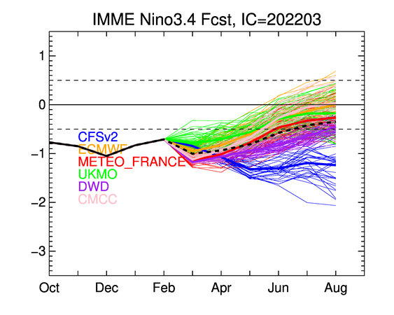
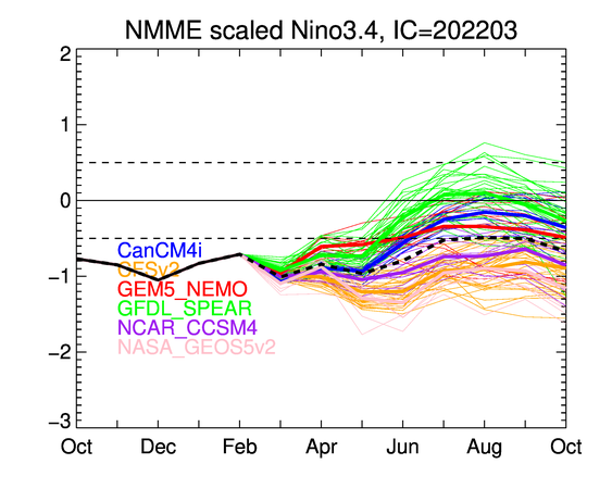
AlphaToOmega wrote:We will know if the chances of +ENSO are done for good once the next IMME/NMME comes out: for now, here are the current charts:
https://i.postimg.cc/Qt4KgwCP/nino34-IMME.png
https://i.postimg.cc/TP2rrrQK/nino34-rescaling-NMME.png
Don't need the NMME for that. We basically already know the window for El Niño or really even +ENSO is closed now. Likely cool neutral or even a 3rd year Niña. Bigger question now is whether or not the MDR warms before the season begins
5 likes
This post was probably an opinion of mine, and in no way is official. Please refer to http://www.hurricanes.gov for official tropical analysis and advisories.
My website, with lots of tropical wx graphics, including satellite and recon: http://cyclonicwx.com
My website, with lots of tropical wx graphics, including satellite and recon: http://cyclonicwx.com
-
AlphaToOmega
- Category 5
- Posts: 1448
- Joined: Sat Jun 26, 2021 10:51 am
- Location: Somewhere in Massachusetts
Re: 2022 indicators: SSTs / SAL / MSLP / shear / steering / instability / images
NotSparta wrote:AlphaToOmega wrote:We will know if the chances of +ENSO are done for good once the next IMME/NMME comes out: for now, here are the current charts:
https://i.postimg.cc/Qt4KgwCP/nino34-IMME.png
https://i.postimg.cc/TP2rrrQK/nino34-rescaling-NMME.png
Don't need the NMME for that. We basically already know the window for El Niño or really even +ENSO is closed now. Likely cool neutral or even a 3rd year Niña. Bigger question now is whether or not the MDR warms before the season begins
We know that the AMM will be positive for ASO. We always knew that the AMO will be positive for ASO. Also, we know the TNA will be positive for ASO; the NMME and recent trends both point to a +TNA for ASO. All of the climate modelling is suggesting above-average precipitation in Africa this year (just like the last couple of years), so we will once again have a strong WAM this season.
As for warming before this season begins, that is more uncertain. This +AMO period, the seasons that featured a -TNA during June were 2000, 2002, 2014, 2015, and 2018; all of these seasons either featured consistent -AMM throughout spring and summer (2000, 2002, and 2018) and/or were +ENSO years (2002, 2014, 2015, and 2018). With a +AMM already called for this hurricane season, this year would have to be +ENSO for the TNA to be negative by June. I am still thinking that a -TNA is possible for June because 2022-2023 still has a chance of being a +ENSO year, but I would say this is becoming exceedingly unlikely. It does not help that all of my potential analog years for 2022 (1998, 1999, 2001, 2005, 2006, 2007, 2008, 2010, 2011, 2012, 2013, 2020, and 2021) all featured +TNA during June.
0 likes
-
AlphaToOmega
- Category 5
- Posts: 1448
- Joined: Sat Jun 26, 2021 10:51 am
- Location: Somewhere in Massachusetts
Re: 2022 indicators: SSTs / SAL / MSLP / shear / steering / instability / images
Here is what we already know from climate model guidance and from recent trends: 2022 will have a +AMO, a +AMM, and a -PDO by ASO. We can also add the continuation of the thermohaline circulation.
Nothing seems to be suggesting a thermohaline circulation shutdown like we saw in 2013. While climate change is weakening the AMOC, it has never been enough (except in 2013) to trigger a major thermohaline circulation slowdown/shutdown like in 2013. Unlike other recent +AMO years, 2013 featured cold anomalies off the Azores, likely due to AMOC changes that year. The climate models do not foresee this, so I do believe it is safe to say that 2022 will not be like 2013.
Examples of seasons with weakened AMOCs (1962 and 2013):
CFSv2 forecast for 2022 ASO:
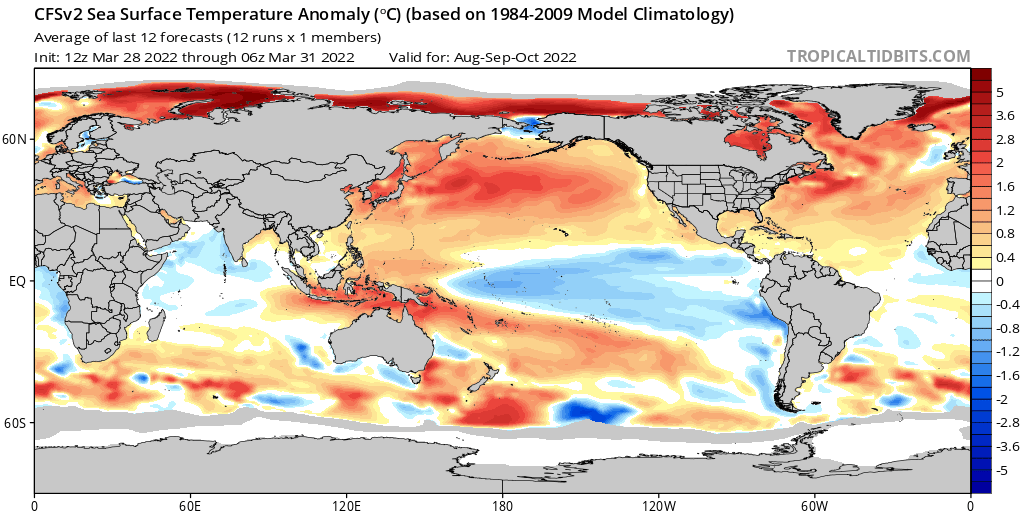
This removes potential analog of 2022 off my list (2013), reducing the possible analog list to 12. Given that we know that 2022 will feature a +AMO, +AMM, and -PDO, the things that matter, as of now, are ENSO, Atlantic Nino, MJO amplitude, and dominant MJO phase. The ENSO is still leaning negative; the MJO will probably not be very strong, but that is still open; the dominant MJO phase will probably be, like most recent La Nina years, Phase III; we still know nothing about the Atlantic Nino this year.
Nothing seems to be suggesting a thermohaline circulation shutdown like we saw in 2013. While climate change is weakening the AMOC, it has never been enough (except in 2013) to trigger a major thermohaline circulation slowdown/shutdown like in 2013. Unlike other recent +AMO years, 2013 featured cold anomalies off the Azores, likely due to AMOC changes that year. The climate models do not foresee this, so I do believe it is safe to say that 2022 will not be like 2013.
Examples of seasons with weakened AMOCs (1962 and 2013):
CFSv2 forecast for 2022 ASO:
This removes potential analog of 2022 off my list (2013), reducing the possible analog list to 12. Given that we know that 2022 will feature a +AMO, +AMM, and -PDO, the things that matter, as of now, are ENSO, Atlantic Nino, MJO amplitude, and dominant MJO phase. The ENSO is still leaning negative; the MJO will probably not be very strong, but that is still open; the dominant MJO phase will probably be, like most recent La Nina years, Phase III; we still know nothing about the Atlantic Nino this year.
- +ENSO/+AtlNino: 2012
- +ENSO/-AtlNino: 2006
- -ENSO/+AtlNino: 1999, 2007, 2008, 2021
- -ENSO/-AtlNino: 1998, 2001, 2005, 2010, 2011, 2020
0 likes
-
Category5Kaiju
- Category 5
- Posts: 4345
- Joined: Thu Dec 24, 2020 12:45 pm
- Location: Seattle during the summer, Phoenix during the winter
Re: 2022 indicators: SSTs / SAL / MSLP / shear / steering / instability / images
AlphaToOmega wrote:Here is what we already know from climate model guidance and from recent trends: 2022 will have a +AMO, a +AMM, and a -PDO by ASO. We can also add the continuation of the thermohaline circulation.
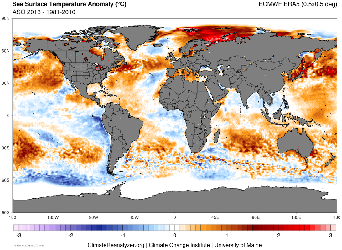
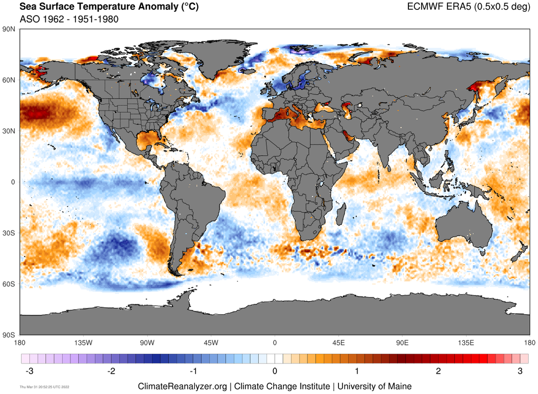
Nothing seems to be suggesting a thermohaline circulation shutdown like we saw in 2013. While climate change is weakening the AMOC, it has never been enough (except in 2013) to trigger a major thermohaline circulation slowdown/shutdown like in 2013. Unlike other recent +AMO years, 2013 featured cold anomalies off the Azores, likely due to AMOC changes that year. The climate models do not foresee this, so I do believe it is safe to say that 2022 will not be like 2013.
Examples of seasons with weakened AMOCs (1962 and 2013):
https://i.postimg.cc/1XGntJB5/era5-0p5deg-28.png
https://i.postimg.cc/8z1WFQq8/era5-0p5deg-35.png
CFSv2 forecast for 2022 ASO:
https://i.postimg.cc/7hfPvb2M/cfs-mon-01-ssta-Mean-month-global-5.png
This removes potential analog of 2022 off my list (2013), reducing the possible analog list to 12. Given that we know that 2022 will feature a +AMO, +AMM, and -PDO, the things that matter, as of now, are ENSO, Atlantic Nino, MJO amplitude, and dominant MJO phase. The ENSO is still leaning negative; the MJO will probably not be very strong, but that is still open; the dominant MJO phase will probably be, like most recent La Nina years, Phase III; we still know nothing about the Atlantic Nino this year.
- +ENSO/+AtlNino: 2012
- +ENSO/-AtlNino: 2006
- -ENSO/+AtlNino: 1999, 2007, 2008, 2021
- -ENSO/-AtlNino: 1998, 2001, 2005, 2010, 2011, 2020
Honestly, at this point I am quite confident to ignore any 2013 comparisons that get thrown around this year (it's inevitable, I know
1 likes
Unless explicitly stated, all information in my posts is based on my own opinions and observations. Tropical storms and hurricanes can be extremely dangerous. Refer to an accredited weather research agency or meteorologist if you need to make serious decisions regarding an approaching storm.
-
DorkyMcDorkface
- Category 5
- Posts: 1039
- Age: 28
- Joined: Mon Sep 30, 2019 1:32 pm
- Location: Mid-Atlantic
Re: 2022 indicators: SSTs / SAL / MSLP / shear / steering / instability / images
April CanSIPS. Not posting Precip or VP because it's still bugged.

1 likes
Please note the thoughts expressed by this account are solely those of the user and are from a hobbyist perspective. For more comprehensive analysis, consult an actual professional meteorologist or meteorological agency.
Floyd 1999 | Isabel 2003 | Hanna 2008 | Irene 2011 | Sandy 2012 | Isaias 2020
-
wxman57

- Moderator-Pro Met

- Posts: 23175
- Age: 68
- Joined: Sat Jun 21, 2003 8:06 pm
- Location: Houston, TX (southwest)
Re: 2022 indicators: SSTs / SAL / MSLP / shear / steering / instability / images
I was going back and forth with Phil Klotzbach last evening. With all March data in, the AMO has turned strongly negative (-1.8C). Phil was saying something about Kelvin wave warming the Nino 3.4 area this month, and strong signs that the Pacific SSTs may be a lot warmer than the models are predicting. That may lead to warm-neutral or even El Nino by peak season. We discussed what this would do for the storm numbers and he said he is going to be significantly lowering his prediction. I won't go into details, but named storms will be below the 30-yr average of 14/7/3. Possibly less than 10 named storms. I'll be at the National Tropical Weather Conference in South Padre with him next week.
That would be great. We could all use a quiet season.

That would be great. We could all use a quiet season.
10 likes
-
Category5Kaiju
- Category 5
- Posts: 4345
- Joined: Thu Dec 24, 2020 12:45 pm
- Location: Seattle during the summer, Phoenix during the winter
Re: 2022 indicators: SSTs / SAL / MSLP / shear / steering / instability / images
wxman57 wrote:I was going back and forth with Phil Klotzbach last evening. With all March data in, the AMO has turned strongly negative (-1.8C). Phil was saying something about Kelvin wave warming the Nino 3.4 area this month, and strong signs that the Pacific SSTs may be a lot warmer than the models are predicting. That may lead to warm-neutral or even El Nino by peak season. We discussed what this would do for the storm numbers and he said he is going to be significantly lowering his prediction. I won't go into details, but named storms will be below the 30-yr average of 14/7/3. Possibly less than 10 named storms. I'll be at the National Tropical Weather Conference in South Padre with him next week.
That would be great. We could all use a quiet season.
http://wxman57.com/images/MarchAMO.png
Have to admit, that's pretty interesting. I initially (as I would think many others here) thought that the door for warm neutral or El Nino was pretty much closed, particularly with the lack of substantial, sustained WWBs in the equatorial Pacific. If a warm neutral or El Nino did manage to happen this year, then that would mean that the cfv2 sst anomaly forecast in particular would have been off by 1.5 C (as of currently projecting). That would be one of the biggest busts in sst modeling in recent times if that were to occur if I am not mistaken.
Personally, I still think watching what happens with the SPB is important.
1 likes
Unless explicitly stated, all information in my posts is based on my own opinions and observations. Tropical storms and hurricanes can be extremely dangerous. Refer to an accredited weather research agency or meteorologist if you need to make serious decisions regarding an approaching storm.
Who is online
Users browsing this forum: No registered users and 162 guests