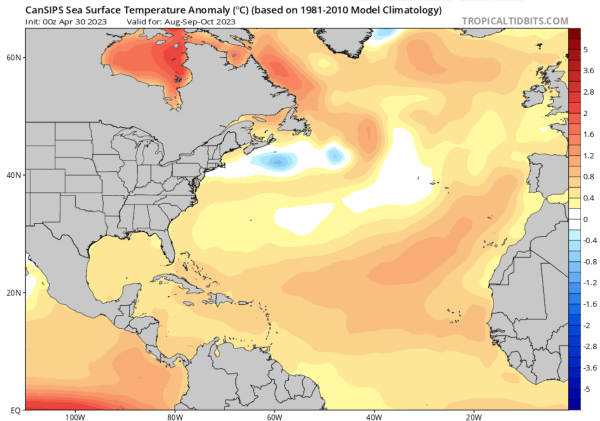
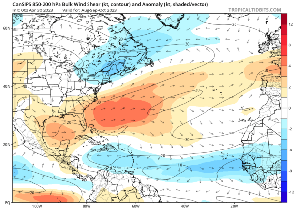
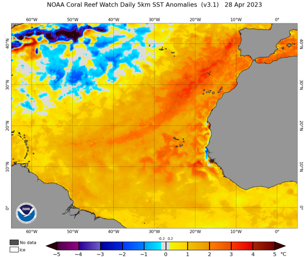
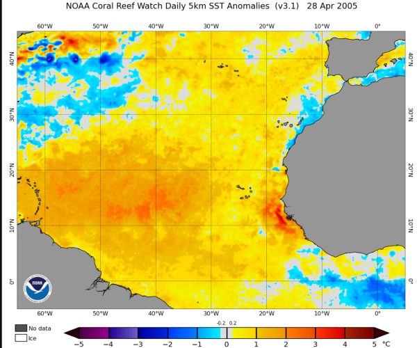
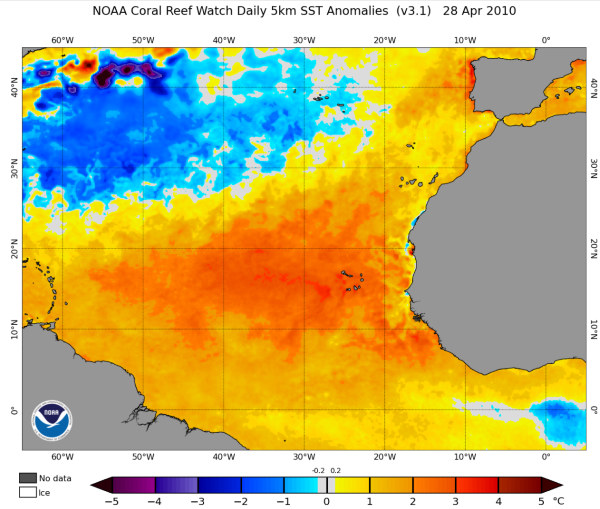
2023 Indicators (SST, SAL, MSLP, Wind shear, Steering, Instability) and Day 16+ Models

This is the general tropical discussion area. Anyone can take their shot at predicting a storms path.

Moderator: S2k Moderators

Forum rules

The posts in this forum are NOT official forecasts and should not be used as such. They are just the opinion of the poster and may or may not be backed by sound meteorological data. They are NOT endorsed by any professional institution or STORM2K. For official information, please refer to products from the National Hurricane Center and National Weather Service.

Help Support Storm2K
Message
Author
User avatar
Category5Kaiju
Category 5
Category 5
Posts: 3438
Age: 22
Joined: Thu Dec 24, 2020 12:45 pm
Location: Seattle

Re: 2023 Indicators (SST, SAL, MSLP, Wind shear, Steering, Instability) and Day 16+ Models

#241 Postby Category5Kaiju » Sat Apr 29, 2023 2:02 pm

DorkyMcDorkface wrote:
Stormybajan wrote:Pretty confident in saying , 2023 is the third warmest East Atlantic year in the last 53 years on record only behind the 2005 and 2010 Hurricane seasons for the date April 28th, even beating out 2016 and 2017. :eek:
https://i.postimg.cc/CL19fZP5/April-28-2023-SST-RESIZED-AGAIN.png
https://i.postimg.cc/NGbWM8xZ/April-28-2005-SST-RESIZED-AGAIN.png
https://i.postimg.cc/mkdq5RDT/April-28-2010-SST-RESIZED-AGAIN.png

I've honestly never seen the Canary Current that beefed up. 2010 still reigns supreme overall in the actual MDR though, widespread anoms of 2C+ encompassing the entirety of the MDR was absolutely insane. Honestly that season underperformed all things considered; perfect storm with La Niña, inactive EPAC and record warm MDR yet it barely managed to eclipse the hyperactive threshold (166 ACE compared to the 1951-2020 median of 159). Would have expected it to exceed 200+ ACE with ease.


I think 2010 is a good example of how having a strong La Nina isn't as favorable for Atlantic activity compared to a weaker one. I recall sometime last year seeing a comparison chart of average Atlantic ACE for each of the different types and strengths of ENSO conditions. Weak La Nina ranks first. Then it is cool neutral. Strong La Nina years are lower in average ACE than weak La Nina years and cool neutral, but also above El Nino years.

There's something about having a very strong La Nina that stunts Atlantic activity potential to an extent. Not exactly sure what that is precisely though.
0 likes   
Unless explicitly stated, all information covered in my posts is based on my opinions and observations. Please refer to a professional meteorologist or an accredited weather research agency otherwise, especially if serious decisions must be made in the event of a potentially life-threatening tropical storm or hurricane.

User avatar
DorkyMcDorkface
Category 2
Category 2
Posts: 743
Age: 26
Joined: Mon Sep 30, 2019 1:32 pm
Location: Mid-Atlantic

Re: 2023 Indicators (SST, SAL, MSLP, Wind shear, Steering, Instability) and Day 16+ Models

#242 Postby DorkyMcDorkface » Sat Apr 29, 2023 2:26 pm

Category5Kaiju wrote:
DorkyMcDorkface wrote:
Stormybajan wrote:Pretty confident in saying , 2023 is the third warmest East Atlantic year in the last 53 years on record only behind the 2005 and 2010 Hurricane seasons for the date April 28th, even beating out 2016 and 2017. :eek:
https://i.postimg.cc/CL19fZP5/April-28-2023-SST-RESIZED-AGAIN.png
https://i.postimg.cc/NGbWM8xZ/April-28-2005-SST-RESIZED-AGAIN.png
https://i.postimg.cc/mkdq5RDT/April-28-2010-SST-RESIZED-AGAIN.png

I've honestly never seen the Canary Current that beefed up. 2010 still reigns supreme overall in the actual MDR though, widespread anoms of 2C+ encompassing the entirety of the MDR was absolutely insane. Honestly that season underperformed all things considered; perfect storm with La Niña, inactive EPAC and record warm MDR yet it barely managed to eclipse the hyperactive threshold (166 ACE compared to the 1951-2020 median of 159). Would have expected it to exceed 200+ ACE with ease.


I think 2010 is a good example of how having a strong La Nina isn't as favorable for Atlantic activity compared to a weaker one. I recall sometime last year seeing a comparison chart of average Atlantic ACE for each of the different types and strengths of ENSO conditions. Weak La Nina ranks first. Then it is cool neutral. Strong La Nina years are lower in average ACE than weak La Nina years and cool neutral, but also above El Nino years.

There's something about having a very strong La Nina that stunts Atlantic activity potential to an extent. Not exactly sure what that is precisely though.

Yeah I've heard of this. Might be Hadley/Walker circulation related as the balance can be upset by particularly strong ENSO events on either side of the spectrum. I'll have to do more research to confirm this though.
0 likes   
Floyd 1999 | Isabel 2003 | Hanna 2008 | Irene 2011 | Sandy 2012 | Isaias 2020

User avatar
Yellow Evan
Professional-Met
Professional-Met
Posts: 15960
Age: 25
Joined: Fri Jul 15, 2011 12:48 pm
Location: Henderson, Nevada/Honolulu, HI
Contact:

Re: 2023 Indicators (SST, SAL, MSLP, Wind shear, Steering, Instability) and Day 16+ Models

#243 Postby Yellow Evan » Sat Apr 29, 2023 3:05 pm

:uarrow: cool subtropics/mid-latitudes limited activity outside of the deep tropics in 2010 + years after an El Niño tend to start slow because it takes time for the atmosphere to respond to the rapidly changing oceanic configuration. And it was still hyperactive.
3 likes   

User avatar
JetFuel_SE
Category 1
Category 1
Posts: 279
Age: 24
Joined: Thu Apr 30, 2020 3:57 pm

Re: 2023 Indicators (SST, SAL, MSLP, Wind shear, Steering, Instability) and Day 16+ Models

#244 Postby JetFuel_SE » Sun Apr 30, 2023 2:32 am

Yellow Evan wrote::uarrow: cool subtropics/mid-latitudes limited activity outside of the deep tropics in 2010 + years after an El Niño tend to start slow because it takes time for the atmosphere to respond to the rapidly changing oceanic configuration. And it was still hyperactive.

Don't need an active early season for hyperactivity, just look at 2004.
0 likes   

User avatar
Yellow Evan
Professional-Met
Professional-Met
Posts: 15960
Age: 25
Joined: Fri Jul 15, 2011 12:48 pm
Location: Henderson, Nevada/Honolulu, HI
Contact:

Re: 2023 Indicators (SST, SAL, MSLP, Wind shear, Steering, Instability) and Day 16+ Models

#245 Postby Yellow Evan » Sun Apr 30, 2023 1:27 pm

JetFuel_SE wrote:
Yellow Evan wrote::uarrow: cool subtropics/mid-latitudes limited activity outside of the deep tropics in 2010 + years after an El Niño tend to start slow because it takes time for the atmosphere to respond to the rapidly changing oceanic configuration. And it was still hyperactive.

Don't need an active early season for hyperactivity, just look at 2004.


2004 had an active early season though. 3 of 6 majors formed in August.
2 likes   

User avatar
JetFuel_SE
Category 1
Category 1
Posts: 279
Age: 24
Joined: Thu Apr 30, 2020 3:57 pm

Re: 2023 Indicators (SST, SAL, MSLP, Wind shear, Steering, Instability) and Day 16+ Models

#246 Postby JetFuel_SE » Sun Apr 30, 2023 2:39 pm

Yellow Evan wrote:
JetFuel_SE wrote:
Yellow Evan wrote::uarrow: cool subtropics/mid-latitudes limited activity outside of the deep tropics in 2010 + years after an El Niño tend to start slow because it takes time for the atmosphere to respond to the rapidly changing oceanic configuration. And it was still hyperactive.

Don't need an active early season for hyperactivity, just look at 2004.


2004 had an active early season though. 3 of 6 majors formed in August.

Early season would be June-July, not August lol.
2 likes   

User avatar
Yellow Evan
Professional-Met
Professional-Met
Posts: 15960
Age: 25
Joined: Fri Jul 15, 2011 12:48 pm
Location: Henderson, Nevada/Honolulu, HI
Contact:

Re: 2023 Indicators (SST, SAL, MSLP, Wind shear, Steering, Instability) and Day 16+ Models

#247 Postby Yellow Evan » Sun Apr 30, 2023 5:08 pm

JetFuel_SE wrote:
Yellow Evan wrote:
JetFuel_SE wrote:Don't need an active early season for hyperactivity, just look at 2004.


2004 had an active early season though. 3 of 6 majors formed in August.

Early season would be June-July, not August lol.


I mean by that metric no season except 2005 or 1933 or 1916 has meaningful early season activity lol. Outside of select high activity years and the occasional CAG, TC activity in those months are from non-tropical origins, which don’t accumulate much ACE or seldom intensify beyond low-end hurricane status.

2010 was pretty quiet until August 25 hence why I noted early season wasn’t active in my original comment.
1 likes   

User avatar
drezee
S2K Supporter
S2K Supporter
Posts: 3644
Joined: Mon Jun 09, 2003 12:49 pm
Location: FL

Re: 2023 Indicators (SST, SAL, MSLP, Wind shear, Steering, Instability) and Day 16+ Models

#248 Postby drezee » Sun Apr 30, 2023 5:20 pm

0 likes   

User avatar
cycloneye
Admin
Admin
Posts: 139602
Age: 67
Joined: Thu Oct 10, 2002 10:54 am
Location: San Juan, Puerto Rico

Re: 2023 Indicators (SST, SAL, MSLP, Wind shear, Steering, Instability) and Day 16+ Models

#249 Postby cycloneye » Sun Apr 30, 2023 6:12 pm

The battle between the upcomming El Niño and the +AMO configuration is starting.

Image
0 likes   
Visit the Caribbean-Central America Weather Thread where you can find at first post web cams,radars
and observations from Caribbean basin members Click Here

User avatar
cycloneye
Admin
Admin
Posts: 139602
Age: 67
Joined: Thu Oct 10, 2002 10:54 am
Location: San Juan, Puerto Rico

Re: 2023 Indicators (SST, SAL, MSLP, Wind shear, Steering, Instability) and Day 16+ Models

#250 Postby cycloneye » Sun Apr 30, 2023 7:11 pm

0 likes   
Visit the Caribbean-Central America Weather Thread where you can find at first post web cams,radars
and observations from Caribbean basin members Click Here

User avatar
Category5Kaiju
Category 5
Category 5
Posts: 3438
Age: 22
Joined: Thu Dec 24, 2020 12:45 pm
Location: Seattle

Re: 2023 Indicators (SST, SAL, MSLP, Wind shear, Steering, Instability) and Day 16+ Models

#251 Postby Category5Kaiju » Sun Apr 30, 2023 7:49 pm

 https://twitter.com/AndyHazelton/status/1652834308652953600


Andy makes a very intriguing point here. Having a traditional, robust El Nino and a scorching tropical Atlantic is going to be a very interesting battle
2 likes   
Unless explicitly stated, all information covered in my posts is based on my opinions and observations. Please refer to a professional meteorologist or an accredited weather research agency otherwise, especially if serious decisions must be made in the event of a potentially life-threatening tropical storm or hurricane.

User avatar
cycloneye
Admin
Admin
Posts: 139602
Age: 67
Joined: Thu Oct 10, 2002 10:54 am
Location: San Juan, Puerto Rico

Re: 2023 Indicators (SST, SAL, MSLP, Wind shear, Steering, Instability) and Day 16+ Models

#252 Postby cycloneye » Sun Apr 30, 2023 7:54 pm

Category5Kaiju wrote:https://twitter.com/AndyHazelton/status/1652834308652953600

Andy makes a very intriguing point here. Having a traditional, robust El Nino and a scorching tropical Atlantic is going to be a very interesting battle


That is me saying that about it only takes one. :D
2 likes   
Visit the Caribbean-Central America Weather Thread where you can find at first post web cams,radars
and observations from Caribbean basin members Click Here

User avatar
cycloneye
Admin
Admin
Posts: 139602
Age: 67
Joined: Thu Oct 10, 2002 10:54 am
Location: San Juan, Puerto Rico

Re: 2023 Indicators (SST, SAL, MSLP, Wind shear, Steering, Instability) and Day 16+ Models

#253 Postby cycloneye » Sun Apr 30, 2023 7:55 pm

0 likes   
Visit the Caribbean-Central America Weather Thread where you can find at first post web cams,radars
and observations from Caribbean basin members Click Here

User avatar
Stormybajan
Category 1
Category 1
Posts: 428
Joined: Thu May 20, 2021 3:21 pm
Location: Windward Islands

Re: 2023 Indicators (SST, SAL, MSLP, Wind shear, Steering, Instability) and Day 16+ Models

#254 Postby Stormybajan » Sun Apr 30, 2023 8:02 pm

Wow, big warm up in SST from April to May from CANSIPS which is no surprise given how boiling it is out there in the east currently, however...I simply do NOT buy this shear run at all lol Nino is coming, a hefty one as well. Thats not a NINO look.. :lol:

Image
Image
0 likes   
Sad West Indies and Manchester United fan ⚽️

User avatar
aspen
Category 5
Category 5
Posts: 8061
Joined: Sat Oct 12, 2019 7:10 pm
Location: Connecticut, USA

Re: 2023 Indicators (SST, SAL, MSLP, Wind shear, Steering, Instability) and Day 16+ Models

#255 Postby aspen » Sun Apr 30, 2023 8:04 pm

cycloneye wrote:The battle between the upcomming El Niño and the +AMO configuration is starting.

https://i.imgur.com/8KdYcAW.png

Bonkers SSTA configuration, but I’m always cautious about latching on to SSTAs this far out. We could very easily see a shift to a much less favorable looking setup after a few weeks or months. If this was during a first-year neutral to weak Nina, I’d expect a hyperactive season up there with some of the big years like ‘95, ‘04, ‘05, and ‘17. Definitely not the case with the pretty much guaranteed Nino.

I think 2023 could follow a similar pattern to 2018: a relatively active MDR with at least one high ACE long-tracked (mainly in the subtropics), but an extremely hostile Caribbean and multiple storms running into shear in the central deep tropics (ex: Issac and Kirk). Enhanced subtropic activity is possible depending on how SSTAs look by June/July.
2 likes   
Irene '11 Sandy '12 Hermine '16 5/15/2018 Derecho Fay '20 Isaias '20 Elsa '21 Henri '21 Ida '21

I am only a meteorology enthusiast who knows a decent amount about tropical cyclones. Look to the professional mets, the NHC, or your local weather office for the best information.

User avatar
DorkyMcDorkface
Category 2
Category 2
Posts: 743
Age: 26
Joined: Mon Sep 30, 2019 1:32 pm
Location: Mid-Atlantic

Re: 2023 Indicators (SST, SAL, MSLP, Wind shear, Steering, Instability) and Day 16+ Models

#256 Postby DorkyMcDorkface » Sun Apr 30, 2023 8:08 pm

Stormybajan wrote:Wow, big warm up in SST from April to May from CANSIPS which is no surprise given how boiling it is out there in the east currently, however...I simply do NOT buy this shear run at all lol Nino is coming, a hefty one as well. Thats not a NINO look.. :lol:

https://i.postimg.cc/rwrCMXnM/May-2023-ASO-Cansips-SST-Resized.png
https://i.postimg.cc/s2CP26qS/May-2023-CANSIPS-Shear-Run-resized.png

Yeah I'm gonna have to file that one under "doubt" for now, not quite sure what it is seeing that would lower shear so significantly during a Niño episode. Surely SSTs alone can't have that effect, right?
1 likes   
Floyd 1999 | Isabel 2003 | Hanna 2008 | Irene 2011 | Sandy 2012 | Isaias 2020

User avatar
cycloneye
Admin
Admin
Posts: 139602
Age: 67
Joined: Thu Oct 10, 2002 10:54 am
Location: San Juan, Puerto Rico

Re: 2023 Indicators (SST, SAL, MSLP, Wind shear, Steering, Instability) and Day 16+ Models

#257 Postby cycloneye » Sun Apr 30, 2023 8:18 pm

August CanSIPS says Shear-Shear-Shear.

Image
1 likes   
Visit the Caribbean-Central America Weather Thread where you can find at first post web cams,radars
and observations from Caribbean basin members Click Here

User avatar
DorkyMcDorkface
Category 2
Category 2
Posts: 743
Age: 26
Joined: Mon Sep 30, 2019 1:32 pm
Location: Mid-Atlantic

Re: 2023 Indicators (SST, SAL, MSLP, Wind shear, Steering, Instability) and Day 16+ Models

#258 Postby DorkyMcDorkface » Sun Apr 30, 2023 8:47 pm

This is probably one of the main reasons why the CanSIPS is not showing noticeably significant shear despite the Niño - it has a dry EPAC anomaly wise which implies inactivity. It does show the -PDO persisting throughout the season so I guess that is why, but once again I still find this perplexing. Yes, perhaps the PDO could be an issue for the EPAC but it still has the aid of ENSO, so why exactly would it be so quiet?
Image
1 likes   
Floyd 1999 | Isabel 2003 | Hanna 2008 | Irene 2011 | Sandy 2012 | Isaias 2020

zzzh
Category 2
Category 2
Posts: 560
Joined: Thu Sep 02, 2021 1:13 pm

Re: 2023 Indicators (SST, SAL, MSLP, Wind shear, Steering, Instability) and Day 16+ Models

#259 Postby zzzh » Sun Apr 30, 2023 9:52 pm

:uarrow: That's just ITCZ retracting to the south due to El Nino, it does not mean inactivity.
7 likes   

User avatar
weeniepatrol
Category 3
Category 3
Posts: 870
Joined: Sat Aug 22, 2020 5:30 pm
Location: WA State

Re: 2023 Indicators (SST, SAL, MSLP, Wind shear, Steering, Instability) and Day 16+ Models

#260 Postby weeniepatrol » Sun Apr 30, 2023 10:41 pm

DorkyMcDorkface wrote:This is probably one of the main reasons why the CanSIPS is not showing noticeably significant shear despite the Niño - it has a dry EPAC anomaly wise which implies inactivity. It does show the -PDO persisting throughout the season so I guess that is why, but once again I still find this perplexing. Yes, perhaps the PDO could be an issue for the EPAC but it still has the aid of ENSO, so why exactly would it be so quiet?


You'd sooner catch me dead than trusting the leaf model :lol:
0 likes   


Return to “Talkin' Tropics”