SST'S and Anomalies in Atlantic and Pacific

This is the general tropical discussion area. Anyone can take their shot at predicting a storms path.

Moderator: S2k Moderators

Forum rules

The posts in this forum are NOT official forecasts and should not be used as such. They are just the opinion of the poster and may or may not be backed by sound meteorological data. They are NOT endorsed by any professional institution or STORM2K. For official information, please refer to products from the National Hurricane Center and National Weather Service.

Help Support Storm2K
Message
Author
User avatar
cycloneye
Admin
Admin
Posts: 146177
Age: 69
Joined: Thu Oct 10, 2002 10:54 am
Location: San Juan, Puerto Rico

#241 Postby cycloneye » Tue Jan 10, 2006 1:23 pm

Image

Atlantic waters are warmer than the last week update of the anomalys.Those anomalys off west Africa are running around +3.0-+3.5c.In the rest of the MDR area they are from +0.5 to +1.0c.And a small spot in the GOM of warmer anomalys are seen.Let's see in the following weeks how the anomalys are as the 2006 season gets closer.
0 likes   

User avatar
wxmann_91
Category 5
Category 5
Posts: 8013
Age: 34
Joined: Fri Jul 15, 2005 2:49 pm
Location: Southern California
Contact:

#242 Postby wxmann_91 » Tue Jan 10, 2006 6:34 pm

Wow, the cool anomalies have really shrunken the last few days!!!
0 likes   

Matt-hurricanewatcher

#243 Postby Matt-hurricanewatcher » Tue Jan 10, 2006 9:18 pm

look at that warm sst's growing off Africa!!! Strong Cape verde season coming most likely.
0 likes   

User avatar
cjrciadt
S2K Supporter
S2K Supporter
Posts: 1616
Joined: Mon Aug 22, 2005 1:11 pm
Location: Kissimmee, FL

#244 Postby cjrciadt » Wed Jan 11, 2006 5:51 pm

Wow that blue has really faded and look at the N. Atlantic!!
0 likes   

MiamiensisWx

#245 Postby MiamiensisWx » Thu Jan 12, 2006 2:54 pm

Image

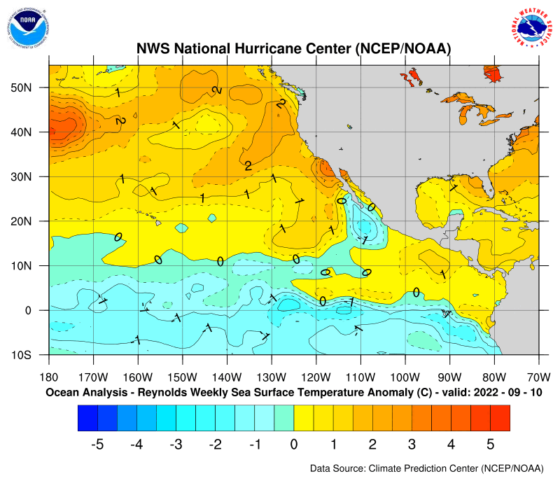
These are the latest Pacific anomalies. Anomalies have now visibly cooled along the equatorial latitude; however, SST anomalies north of the equatorial latitude have warmed significantly as well. Interesting... it is also important to note that the PDO is now leaning towards neutral or positive.
0 likes   

User avatar
cycloneye
Admin
Admin
Posts: 146177
Age: 69
Joined: Thu Oct 10, 2002 10:54 am
Location: San Juan, Puerto Rico

#246 Postby cycloneye » Thu Jan 12, 2006 6:05 pm

Image

Another graphic that shows the cooling in the pacific that CPC officially said it's La Nina right now there.
0 likes   
Visit the Caribbean-Central America Weather Thread where you can find at first post web cams,radars
and observations from Caribbean basin members Click Here

User avatar
cycloneye
Admin
Admin
Posts: 146177
Age: 69
Joined: Thu Oct 10, 2002 10:54 am
Location: San Juan, Puerto Rico

#247 Postby cycloneye » Mon Jan 16, 2006 4:37 pm

Image

Above is the latest update of the Atlantic anomalys.It shows a slight cooling in the western atlantic but basiclly no change in the MDR area between Africa and the lesser antilles.Also the warm spot in the GOM has grown a bit.

Image

The latest update of the Pacific anomalys show la nina type anomalys so no change there.
0 likes   

User avatar
Hurricaneman
Category 5
Category 5
Posts: 7392
Age: 45
Joined: Tue Aug 31, 2004 3:24 pm
Location: central florida

#248 Postby Hurricaneman » Wed Jan 18, 2006 2:32 am

It seems to me that the La Nina is getting stronger or is it just me
0 likes   

Matt-hurricanewatcher

#249 Postby Matt-hurricanewatcher » Wed Jan 18, 2006 3:18 am

Lets see if La nina can develop into a El nino 1998 strength La nina!!!!
0 likes   

Jim Hughes
Category 3
Category 3
Posts: 825
Joined: Sun Jul 24, 2005 1:52 pm
Location: Martinsburg West Virginia

#250 Postby Jim Hughes » Wed Jan 18, 2006 7:09 am

Hurricaneman wrote:It seems to me that the La Nina is getting stronger or is it just me


The SST's are about the same temperature, anomaly wise. The SOI has finally joined in though. Some moderate to strong daily positive readings are showing up.

They are meaningless alone but they add up to a bigger picture if they continue. Today's, Long Paddock Reading, is the strongest positive reading since 2004. Darwins pressure is also quite low. It usually takes another month or more to see it at this level. So it makes you wonder what kind of readings lie ahead.

The only thing that could possibly stop the La Nina freight train now is a large volcanic eruption or a solar pattern change. The Augustine volcano in Alaska has been at a heightened alert level lately but the eruptions have not been all that large. History has shown that the eruption must usually occur at the lower latitudes. So it probably would not have much of an effect even if it was a fairly large eruption.

The eruptions seem to interfere with the Hadley circulation. The SO2 levels seem to be as important as the dust here in my opinion.


Jim
0 likes   

CHRISTY

CHECK OUT THIS LOOP..THOUGHT IT WAS COOL!!

#251 Postby CHRISTY » Wed Jan 18, 2006 9:49 am

Image
0 likes   

CHRISTY

these were yesterdays....

#252 Postby CHRISTY » Wed Jan 18, 2006 10:39 am

Image
0 likes   

User avatar
P.K.
Professional-Met
Professional-Met
Posts: 5149
Joined: Thu Sep 23, 2004 5:57 pm
Location: Watford, England
Contact:

#253 Postby P.K. » Wed Jan 18, 2006 10:41 am

From the BoM.

Australian Government Bureau of Meteorology
Northern Territory
Darwin RSMC - Australia

Weekly Tropical Climate Note


at 1400 CST Tuesday 17 January 2006

El Nino-Southern Oscillation Update
The 30-day SOI has mostly been within one standard deviation of the long-term mean from the middle of June, with an upward trend from late August until a peak in mid November. On 14 January it was +5, with contributing pressure anomalies of +0.7 hPa at Darwin and +1.7 at Tahiti. The official monthly SOI for December was +1 and its 5-month running mean centred on October was also +1.

Other indicators are also generally supportive of the El Nino Southern Oscillation remaining within the neutral range, though some weak La Nina characteristics are apparent. The east Pacific near-equatorial sea-surface temperature [SST] cool tongue is slightly cooler than normal, with larger cool anomalies apparent in the sub-surface. The easterly trade winds over much of the near-equatorial western Pacific have been mostly been stronger than average in recent months while westerly wind anomalies have typically been observed in the tropical eastern Indian Ocean. This pattern is consistent with an enhanced Walker Circulation, with Australian and Indonesian longitudes being the broad focus of recent tropical convection. Outgoing longwave radiation [proxy for cloudiness] is consistent, showing increased tropical convection over this region.

See http://www.bom.gov.au/climate/enso/ for the Bureau's "ENSO Wrap-Up", including links to a compilation of ENSO model predictions. The majority of these models, including the Australian POAMA model, suggest neutral conditions are likely to persist at least through the [southern hemisphere] summer months.

http://www.bom.gov.au/climate/tropnote/tropnote.shtml
0 likes   

Jim Hughes
Category 3
Category 3
Posts: 825
Joined: Sun Jul 24, 2005 1:52 pm
Location: Martinsburg West Virginia

#254 Postby Jim Hughes » Wed Jan 18, 2006 10:59 am

P.K.,

I know they are different then Long Paddock but they are basically looking at the same data so I am somewhat surprised by their comments. I guess they are not putting to much emphasis in this recent SOI trend the past week.

The + 21.30 average during the past week is somewhat meaningless but you have to watch out for these developing trends at this time of the year. I would be more inclined to give it more weight if occurred down the road a ways in another 4-8 weeks but it still could be an important indicator.

Especially when you consider the overall absence of positve trends like this the past few years. Lets see what continues. They may be whistling a different tune next update.


Jim
0 likes   

User avatar
x-y-no
Category 5
Category 5
Posts: 8359
Age: 65
Joined: Wed Aug 11, 2004 12:14 pm
Location: Fort Lauderdale, FL

#255 Postby x-y-no » Wed Jan 18, 2006 11:03 am

Jim Hughes wrote:P.K.,

I know they are different then Long Paddock but they are basically looking at the same data so I am somewhat surprised by their comments. I guess they are not putting to much emphasis in this recent SOI trend the past week.

The + 21.30 average during the past week is somewhat meaningless but you have to watch out for these developing trends at this time of the year. I would be more inclined to give it more weight if occurred down the road a ways in another 4-8 weeks but it still could be an important indicator.

Especially when you consider the overall absence of positve trends like this the past few years. Lets see what continues. They may be whistling a different tune next update.


Jim


I'm inclined to agree that this is starting to look more significant, Jim.
0 likes   

CHRISTY

QUESTION??

#256 Postby CHRISTY » Wed Jan 18, 2006 11:11 am

SO WAIT ALL THIS MEANS...WE MIGHT HAVE LA NINA OR EL NINO??S0 IAM GUESSING GOOD NEWS FOR THIS YEAR?
0 likes   

User avatar
x-y-no
Category 5
Category 5
Posts: 8359
Age: 65
Joined: Wed Aug 11, 2004 12:14 pm
Location: Fort Lauderdale, FL

Re: QUESTION??

#257 Postby x-y-no » Wed Jan 18, 2006 11:38 am

CHRISTY wrote:SO WAIT ALL THIS MEANS...WE MIGHT HAVE LA NINA OR EL NINO??S0 IAM GUESSING GOOD NEWS FOR THIS YEAR?


Almost certainly not El Niño.

All signs so far indicate another very busy year.
0 likes   

CHRISTY

thanks for answering my question...

#258 Postby CHRISTY » Wed Jan 18, 2006 12:06 pm

oh wow...thanks for answering my question..ever since the 2005 hurricane seson ended for some reason i have a gut feeling 2006 is going to be just as bad or maybe even worse,especially if we are suppose to have a strong cape verde seson. iam gonna be ready!
0 likes   

User avatar
P.K.
Professional-Met
Professional-Met
Posts: 5149
Joined: Thu Sep 23, 2004 5:57 pm
Location: Watford, England
Contact:

#259 Postby P.K. » Wed Jan 18, 2006 12:26 pm

Jim Hughes wrote:P.K.,

I know they are different then Long Paddock but they are basically looking at the same data so I am somewhat surprised by their comments. I guess they are not putting to much emphasis in this recent SOI trend the past week.


I'm a bit confused here, who is Long Paddock?

Here is what the ECMWF ensembles are predicting http://www.ecmwf.int/products/forecasts/d/getchart/catalog/products/forecasts/seasonal/forecast/plumes/nino_plumes_public_sys2!3!200512!chart.gif
http://www.ecmwf.int/products/forecasts/d/getchart/catalog/products/forecasts/seasonal/forecast/plumes/nino_plumes_public_sys2!3.4!200512!chart.gif
http://www.ecmwf.int/products/forecasts/d/getchart/catalog/products/forecasts/seasonal/forecast/plumes/nino_plumes_public_sys2!4!200512!chart.gif
0 likes   

Jim Hughes
Category 3
Category 3
Posts: 825
Joined: Sun Jul 24, 2005 1:52 pm
Location: Martinsburg West Virginia

#260 Postby Jim Hughes » Wed Jan 18, 2006 2:22 pm

P.K. wrote:
I'm a bit confused here, who is Long Paddock?


It is an ENSO website put out by the Queensland government. I have been monitoring the ENSO there for about a decade now. They give out daily readings of the SOI. It's great if you are trying to observe the cyclical nature of the SOI in regards to other possible things.

You can find some other things there if you fish around. Here'e the SOI URL for the last 30 days. You can branch out from there.

http://www.longpaddock.qld.gov.au/Seaso ... index.html


Jim
0 likes   


Return to “Talkin' Tropics”

Who is online

Users browsing this forum: No registered users and 74 guests