GOM/Caribbean/Atlantic Ocean SST'S and Anomalies

This is the general tropical discussion area. Anyone can take their shot at predicting a storms path.

Moderator: S2k Moderators

Forum rules

The posts in this forum are NOT official forecasts and should not be used as such. They are just the opinion of the poster and may or may not be backed by sound meteorological data. They are NOT endorsed by any professional institution or STORM2K. For official information, please refer to products from the National Hurricane Center and National Weather Service.

Help Support Storm2K
Message
Author
User avatar
wxmann_91
Category 5
Category 5
Posts: 8013
Age: 34
Joined: Fri Jul 15, 2005 2:49 pm
Location: Southern California
Contact:

Re: GOM/Caribbean Sea/Atlantic SST's and Anomalies

#241 Postby wxmann_91 » Mon Jul 02, 2007 4:27 pm

Cyclenall wrote:
wxmann_91 wrote:There is a way...

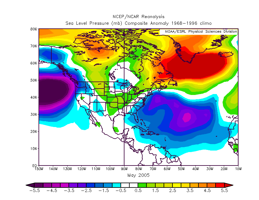
June 2007 data will take some time to come out, but here was June 2005 data. Needless to say, it speaks for itself.

(map from http://www.cdc.noaa.gov/cgi-bin/Composites/printpage.pl )

*cut*

That page is too confusing to use to get the data I want. Can we compare May 2005 and May 2007 then?


Here it is...

Image

Image


The gist is... abnormally low ambient pressures in the ATL, even before the season started, allowed the ITCZ to get an early heads start and end up abnormally far north. This inital step has been slower to occur this year.
0 likes   

User avatar
cycloneye
Admin
Admin
Posts: 145870
Age: 69
Joined: Thu Oct 10, 2002 10:54 am
Location: San Juan, Puerto Rico

Re: GOM/Caribbean Sea/Atlantic SST's and Anomalies

#242 Postby cycloneye » Mon Jul 02, 2007 5:09 pm

Reynolds Atlantic Anomalies weekly Update

:uarrow: :uarrow: :uarrow: :uarrow: :uarrow: :uarrow: :uarrow: :uarrow: :uarrow:

The latest Reynolds Anomalies of June 30th data shows a average MDR area,a more warmer Western and Central Atlantic and a very warm Northern Atlantic.
0 likes   

User avatar
terstorm1012
S2K Supporter
S2K Supporter
Posts: 1314
Age: 43
Joined: Fri Sep 10, 2004 5:36 pm
Location: Millersburg, PA

#243 Postby terstorm1012 » Mon Jul 02, 2007 5:13 pm

So does this mean everyone will once again rush to update their storm predictions for the season after appearing to back off on them a few weeks ago?
0 likes   

User avatar
Cyclenall
Category 5
Category 5
Posts: 6667
Joined: Thu Jun 08, 2006 10:01 pm
Location: Ontario, Canada

Re: GOM/Caribbean Sea/Atlantic SST's and Anomalies

#244 Postby Cyclenall » Mon Jul 02, 2007 5:21 pm

wxmann_91 wrote:Here it is...

*cut*

*cut*

The gist is... abnormally low ambient pressures in the ATL, even before the season started, allowed the ITCZ to get an early heads start and end up abnormally far north. This inital step has been slower to occur this year.

Excellent images. It gives you an idea of the pressures that were in place in May. Clearly 2005 had a large area of low ambient pressures but I notice it was mainly in the middle of the North Atlantic.
0 likes   

User avatar
cycloneye
Admin
Admin
Posts: 145870
Age: 69
Joined: Thu Oct 10, 2002 10:54 am
Location: San Juan, Puerto Rico

Re:

#245 Postby cycloneye » Mon Jul 02, 2007 5:40 pm

terstorm1012 wrote:So does this mean everyone will once again rush to update their storm predictions for the season after appearing to back off on them a few weeks ago?


Well,yes the anomalies haved turned more warmer in different parts of the Atlantic in the past 2 weeks.Now let's see if this is a warming trend or are fluctuations.However,being the waters warm doesn't guarantee that a system will develop as other factors come to play an important roll.But certainly,the sst's and anomalies factor is important as it helps fuel a system.
0 likes   

User avatar
vacanechaser
Category 5
Category 5
Posts: 1461
Joined: Wed Dec 03, 2003 9:34 pm
Location: Portsmouth, Va
Contact:

Re: Atlantic Reynolds Anomalies Update=Warmer West/Central Atl

#246 Postby vacanechaser » Mon Jul 02, 2007 6:18 pm

nice warm pool off the carolina and virginia coast... does it look like a target area for later in the season??? wow, big turn around in temps...


Jesse V. Bass III
http://www.vastormphoto.com
Hurricane Intercept Research Team
0 likes   

User avatar
cycloneye
Admin
Admin
Posts: 145870
Age: 69
Joined: Thu Oct 10, 2002 10:54 am
Location: San Juan, Puerto Rico

Re: Atlantic Reynolds Anomalies Update=Warmer West/Central Atl

#247 Postby cycloneye » Mon Jul 02, 2007 6:52 pm

vacanechaser wrote:nice warm pool off the carolina and virginia coast... does it look like a target area for later in the season??? wow, big turn around in temps...


Jesse V. Bass III
http://www.vastormphoto.com
Hurricane Intercept Research Team


Yes Jesse.It's a big turnaround of the anomalies.Trend or only fluctuations? I would wait for a couple more of the Reynold updates to see how will the anomalies be by then.It will be interesting to see how will they be when the peak of the season arrives as some outlooks haved been forecasting cooler anomalies by then.
0 likes   

User avatar
Tampa Bay Hurricane
Category 5
Category 5
Posts: 5597
Age: 37
Joined: Fri Jul 22, 2005 7:54 pm
Location: St. Petersburg, FL

Re: GOM/Caribbean Sea/Atlantic SST's and Anomalies

#248 Postby Tampa Bay Hurricane » Mon Jul 02, 2007 8:22 pm

caribepr wrote:Tampa Bay...truthfully, you worry me more than any weather potentials. Maybe it is because I am old, maybe it is because I accept there is nothing I can do but be prepared and keep a careful eye on the weather. But I feel the stress of your fear/concern through your posts.
While your anxiousness is understandable from the point of view of what has happened in the recent past, I would seriously advise you to get some sort of outdoor hobby...working with little kids this summer at a day camp in your area, or if that is not feasible, doing weekend activities with needy kids, like a big brother/big sister group? It is important to concentrate on the life we are living, while being as prepared as possible for the life to come, be it days, weeks, months or years from now.
The reality is, each day is precious. We may get 100's of them. How wasteful to lose even one worrying (to the point of being frozen in the headlights) about what may or may not happen! Hope for the best!!! Prepare for the worst, and in the meantime, live each day of your life. Because... 97.3 %...it's BEAUTIFUL!!!


Thank you for advice...
I'm not as worried now though at the time I was surprised...
but now I'm less worried...
I sometimes get bursts of worry but right now I'm much calmer...
usually with me something will worry me intensely for a short
time and then I think about other things...
In this case it was mostly surprise at how the heat content
exceeds 2005 at this time...
But yes that is definately true...worries become exaggerated in
my mind...but I get it under control usually after about 10-25 minutes...
The worry comes in episodes...but I rationalized that the probability
of a major hurricane hitting my area in the nightmare fashion is very
low...so that makes me much calmer...
0 likes   

User avatar
Aquawind
Category 5
Category 5
Posts: 6714
Age: 62
Joined: Mon Jun 16, 2003 10:41 pm
Location: Salisbury, NC
Contact:

#249 Postby Aquawind » Tue Jul 03, 2007 4:44 am

Interesting Warm to the north and cool south in general terms excluding the caribbean. It's so close to norm it's moot. SSTs will not be a limiting factor..sure maybe fewer majors over the same area but it's plenty warm already. The MDR is so close but still early. I did not expect the +2F to expand like most all of the warm anomalies did.

I still don't see what pattern change they expect to cool the Atl. This pattern is just warming. At this rate it is going to take some serious upwelling to cool the Atl. Granted those SSTs can flucuate due to short and long term changes but the areas already above normal are just getting warmer deeper. The trough along the east coast certainly hasn't cooled things to much. The Azores certainly hasn't done much cooling as the temps are balmy in the vacinity. Really the cool anomalies are so small and close to average they are moot looking at all of the factors.
0 likes   

User avatar
drezee
S2K Supporter
S2K Supporter
Posts: 3664
Joined: Mon Jun 09, 2003 12:49 pm
Location: FL

Re: Atlantic Reynolds Anomalies Update=Warmer West/Central Atl

#250 Postby drezee » Tue Jul 03, 2007 2:30 pm

Let me start off by saying, yes I know that the winds are all but calm in the central GOM. This happens every year at some point. I will say that even with Calm winds buoy 42003, a deep water buoy, never got to 31.9 C before August in 2004 or 2005. 2006, it happened in mid july.

http://www.ndbc.noaa.gov/station_page.php?station=42003
0 likes   

Aric Dunn
Category 5
Category 5
Posts: 21238
Age: 42
Joined: Sun Sep 19, 2004 9:58 pm
Location: Ready for the Chase.
Contact:

Re: Atlantic Reynolds Anomalies Update=Warmer West/Central Atl

#251 Postby Aric Dunn » Tue Jul 03, 2007 3:37 pm

here is an inetresting comparison..
in one month on august first .. this is how much warmer the atlantic needs to get if we want to see 2005 levels lol

2007 now
Image

2005 august first
Image
0 likes   

User avatar
Tampa Bay Hurricane
Category 5
Category 5
Posts: 5597
Age: 37
Joined: Fri Jul 22, 2005 7:54 pm
Location: St. Petersburg, FL

Re: GOM/Caribbean Sea/Atlantic Ocean SST'S and Anomalies

#252 Postby Tampa Bay Hurricane » Wed Jul 04, 2007 10:41 am

2005 and 2007 look very close
but of course too much dry air right now
should prevent any short
term development.
I think things will explode in August.

EDITED: ssts map rather impressive:
http://wxmaps.org/pix/hurpot.html#ATL
Last edited by Tampa Bay Hurricane on Wed Jul 04, 2007 11:33 am, edited 1 time in total.
0 likes   

User avatar
'CaneFreak
Category 5
Category 5
Posts: 1486
Joined: Mon Jun 05, 2006 10:50 am
Location: New Bern, NC

#253 Postby 'CaneFreak » Wed Jul 04, 2007 10:53 am

Just to let you know...that is not a heat content map...that is a maximum potential intensity map....two different things....like apples and chicken or something...
0 likes   

User avatar
skysummit
S2K Supporter
S2K Supporter
Posts: 5305
Age: 49
Joined: Tue Aug 31, 2004 11:09 pm
Location: Ponchatoula, LA
Contact:

Re: GOM/Caribbean Sea/Atlantic Ocean SST'S and Anomalies

#254 Postby skysummit » Wed Jul 04, 2007 10:55 am

I'm pretty sure Aric knows which maps those are. Plus....he's talking about SSTs, not content. That's darn close Aric!!!
0 likes   

User avatar
x-y-no
Category 5
Category 5
Posts: 8359
Age: 65
Joined: Wed Aug 11, 2004 12:14 pm
Location: Fort Lauderdale, FL

#255 Postby x-y-no » Wed Jul 04, 2007 10:57 am

Not really fair to compare July 2 with August 1 - the basin warms up a lot in July.

Here's early July 2005:

Image

Note that 2007 is warmer in the Gulf and western Caribbean, but 2005 was substantially warmer in the MDR and especially north of the leeward islands (where we saw significant cyclogenesis that year.)
0 likes   

User avatar
Tampa Bay Hurricane
Category 5
Category 5
Posts: 5597
Age: 37
Joined: Fri Jul 22, 2005 7:54 pm
Location: St. Petersburg, FL

Re:

#256 Postby Tampa Bay Hurricane » Wed Jul 04, 2007 11:33 am

'CaneFreak wrote:Just to let you know...that is not a heat content map...that is a maximum potential intensity map....two different things....like apples and chicken or something...


thank you. :D ..I'll correct that...basically so the ssts look very conducive
to strong storms...so i think we see major hurricanes in august and september
and plenty of them..
0 likes   

User avatar
cycloneye
Admin
Admin
Posts: 145870
Age: 69
Joined: Thu Oct 10, 2002 10:54 am
Location: San Juan, Puerto Rico

Re: GOM/Caribbean Sea/Atlantic Ocean SST'S and Anomalies

#257 Postby cycloneye » Wed Jul 04, 2007 2:43 pm

Image

This is the weekly forecast of sst's from CFS.They continue to cool down the MDR area by August and September.Maybe this is what TSR (Tropical Storm Risk) July forecast talks about this cooldown in the MDR due to the strong trade winds.
0 likes   

User avatar
Aquawind
Category 5
Category 5
Posts: 6714
Age: 62
Joined: Mon Jun 16, 2003 10:41 pm
Location: Salisbury, NC
Contact:

#258 Postby Aquawind » Wed Jul 04, 2007 2:55 pm

Interesting CFS forecast Luis.. The MDR is within .5 of normal so no biggie. Still above in the west except for along the eastern seaboard. I assume the trough is expected to keep the SSTs in check somewhat. I am a bit suprised at the continued westward expension of the cool water in the Pacific. Like any other forecast it can be wrong..
0 likes   

Aric Dunn
Category 5
Category 5
Posts: 21238
Age: 42
Joined: Sun Sep 19, 2004 9:58 pm
Location: Ready for the Chase.
Contact:

Re:

#259 Postby Aric Dunn » Wed Jul 04, 2007 6:31 pm

x-y-no wrote:Not really fair to compare July 2 with August 1 - the basin warms up a lot in July.

Here's early July 2005:

Image

Note that 2007 is warmer in the Gulf and western Caribbean, but 2005 was substantially warmer in the MDR and especially north of the leeward islands (where we saw significant cyclogenesis that year.)


umm .. wow.. well i guess no one figured out why i was comparing aug first 05 with now..

well i cant really say it any simpler !! seee 05 was one of if not the warmest ssts on record.. so i picked august 05 as a good time to compare because ssts are nearly at there warmest.. and i said in my original post that the SSTS have quite a bit to go if its going to be anywhere near august 05 when that time comes in a month.. the whole point is that there is a lot of water that needs to warm up.. i guess i should have put july 05 in there as well just to make it easier..
anyway no big deal ...
0 likes   

User avatar
vacanechaser
Category 5
Category 5
Posts: 1461
Joined: Wed Dec 03, 2003 9:34 pm
Location: Portsmouth, Va
Contact:

Re: GOM/Caribbean Sea/Atlantic Ocean SST'S and Anomalies

#260 Postby vacanechaser » Wed Jul 04, 2007 8:12 pm

cycloneye wrote:Image

This is the weekly forecast of sst's from CFS.They continue to cool down the MDR area by August and September.Maybe this is what TSR (Tropical Storm Risk) July forecast talks about this cooldown in the MDR due to the strong trade winds.


notice an expanding and cooling in the nino region too... that is pretty impressive... that should be watched as well...


Jesse V. Bass III
http://www.vastormphoto.com
Hurricane Intercept Research Team
0 likes   


Return to “Talkin' Tropics”

Who is online

Users browsing this forum: Google Adsense [Bot], HurricaneBelle and 31 guests