
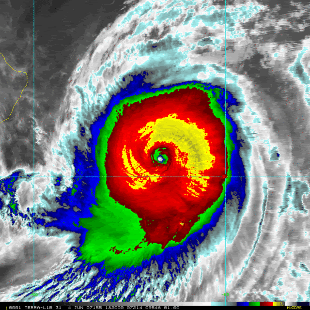
Wow Peter, thats impressive, quite a large inflow there as well, windstorm's image is even more impressive, I know estimates say 920mbs but I wouldn't be al lthat suprised to see it sub 910mbs given the Sat estimates that we have been seeing today!
textbook cat-5 IMO.
Akash and Gonu thread
Moderator: S2k Moderators
Forum rules

The posts in this forum are NOT official forecasts and should not be used as such. They are just the opinion of the poster and may or may not be backed by sound meteorological data. They are NOT endorsed by any professional institution or STORM2K. For official information, please refer to products from the National Hurricane Center and National Weather Service.

-
Stratosphere747
- Category 5

- Posts: 3772
- Joined: Thu Sep 11, 2003 8:34 pm
- Location: Surfside Beach/Freeport Tx
- Contact:

-
curtadams
- S2K Supporter

- Posts: 1122
- Joined: Sun Aug 28, 2005 7:57 pm
- Location: Orange, California
- Contact:
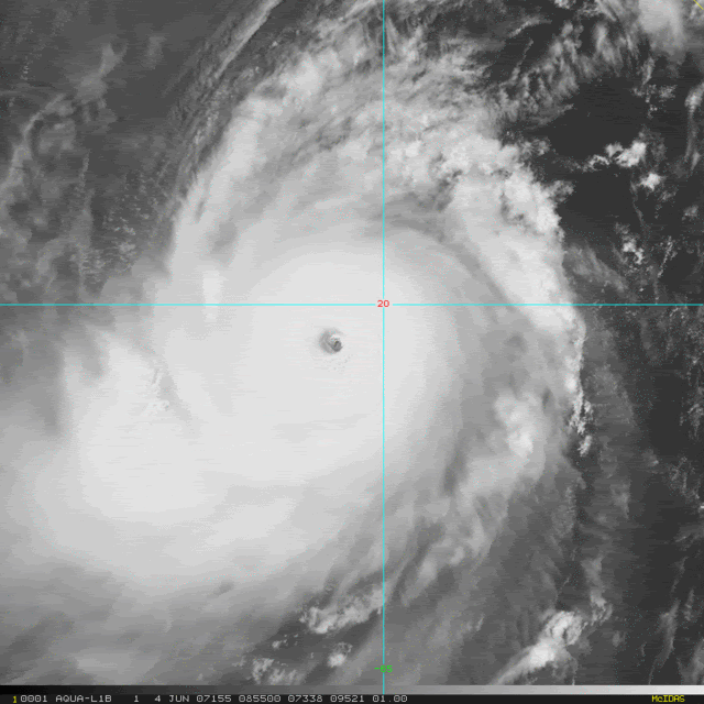
Meso wrote:Another image
Them colored vis shots are sure purty! You can see the dry air on the left side of the storm - lots of high outflow but very little convection.
0 likes
-
Coredesat
-
curtadams
- S2K Supporter
- Posts: 1122
- Joined: Sun Aug 28, 2005 7:57 pm
- Location: Orange, California
- Contact:
The oil facility is in Muscat and not predicted to see worse than tropical storm conditions. That might be a problem if the Omanis didn't build the thing to withstand storms but typical TS conditions don't damage industrial structures much. Floods could potentially be a problem. However Omani natural gas export goes through a terminal on Sur which is forecast to see Cat 1 conditions with onshore winds, for a significant surge hazard, although the shape of the coast will protect it from deep-ocean boomer waves. Note how close the LNG tanks are to the ocean. That won't affect us too much, since the natural gas goes to Asia mostly, but it could be quite bad for India, which is already facing NG shortages.
0 likes
-
DESTRUCTION5

- Category 5
- Posts: 4430
- Age: 44
- Joined: Wed Sep 03, 2003 11:25 am
- Location: Stuart, FL
-
Coredesat

-
DESTRUCTION5
- Category 5
- Posts: 4430
- Age: 44
- Joined: Wed Sep 03, 2003 11:25 am
- Location: Stuart, FL
-
Matt-hurricanewatcher
-
Tampa Bay Hurricane

- Category 5
- Posts: 5597
- Age: 38
- Joined: Fri Jul 22, 2005 7:54 pm
- Location: St. Petersburg, FL
-
windstorm99

- S2K Supporter
- Posts: 1578
- Age: 48
- Joined: Sat May 26, 2007 8:10 am
- Location: Miami, Florida
- Contact:
-
Weatherfreak000
-
HurricaneRobert
- Category 3

- Posts: 812
- Joined: Fri May 18, 2007 9:31 pm
-
terstorm1012

- S2K Supporter
- Posts: 1314
- Age: 44
- Joined: Fri Sep 10, 2004 5:36 pm
- Location: Millersburg, PA
HurricaneRobert wrote:Is it an eyewall replacement cycle? I was following Gonu with NRL satellite images, but that site has been down. Maybe Gonu blew it apart.
The site's likely down because every oil trader and speculator in the world is looking at it and they've overloaded the servers.
The following post is NOT an official forecast and should not be used as such. It is just the opinion of the poster and may or may not be backed by sound meteorological data. It is NOT endorsed by any professional institution or storm2k.org. For official information, please refer to the NHC and NWS products.
I think it's likely dry air will start to get sucked into Gonu and it should start to weaken.
0 likes


HurricaneRobert wrote:Is it an eyewall replacement cycle? I was following Gonu with NRL satellite images, but that site has been down. Maybe Gonu blew it apart.
I don't think the NRL servers are on a ship if that is even possible. Gonu blowing apart a tropical cyclone website would be class. Why the NRL down anyways?
I think Gonu has been increadible TC to track and could make tropical cyclone history in the coming days.
0 likes

Who is online
Users browsing this forum: Hurricane2022 and 207 guests