Remnants of Andrea-Thread 2
Moderator: S2k Moderators
Forum rules

The posts in this forum are NOT official forecasts and should not be used as such. They are just the opinion of the poster and may or may not be backed by sound meteorological data. They are NOT endorsed by any professional institution or STORM2K. For official information, please refer to products from the National Hurricane Center and National Weather Service.


Time-sensitive post here...
Interesting satellite loop for anyone who's interested. Go run a visible loop (here's the site I use: http://wwwghcc.msfc.nasa.gov/GOES/goeseastconus.html) at 1 KM resolution.
Watch to the NW of the "blob". You'll see all of the clouds in that area get obliterated by outflow from the convection--the outflow origniates at the convection and spreads NW. You'll see the cumulus field disappear as it passes.
If you look at the KMLB radar, you'll see what little precip is evident to the NW of the center disappear as the outflow passes.
If I am not mistaken, outflow at low levels like this is not an indicator for development of a TC. To develop, we'd want a great deal of convecgent flow at the surface. Outflow suggests that wind is heading OUT, not converging in. Can anyone correct/improve/clarify this explanation?
WJS3
0 likes
-
Evil Jeremy

- S2K Supporter

- Posts: 5463
- Age: 32
- Joined: Mon Apr 10, 2006 2:10 pm
- Location: Los Angeles, CA
Andrea was killed the first time by synoptic level shear (among other things), not by outflow from the sytem's own storms, no?
How would you say that's a subtropical cyclone I described? Outflow can happen in a mature tropical cyclone too. You can see outflow boundaries even in well developed hurricanes.
Thanks
WJS3
How would you say that's a subtropical cyclone I described? Outflow can happen in a mature tropical cyclone too. You can see outflow boundaries even in well developed hurricanes.
Thanks
WJS3
0 likes

Put together this colour IR loop in Macromedia/Adobe Flash (hence the relatively sucky quality)... from 0715Z to 1545Z
http://img508.imageshack.us/img508/9051/andrearemnantirgz8.gif - GIF format
http://img409.imageshack.us/my.php?image=andreahj5.swf - Shockwave Flash (swf) format
http://img508.imageshack.us/img508/9051/andrearemnantirgz8.gif - GIF format
http://img409.imageshack.us/my.php?image=andreahj5.swf - Shockwave Flash (swf) format
0 likes
-
Blown Away

- S2K Supporter
- Posts: 10253
- Joined: Wed May 26, 2004 6:17 am
Looking at the Melbourne radar, I see the convection building to the N and S from the east side of the circulation. Andrea looks better today than she did anytime yesterday, IMO. Buoy off Melbourne, S of Andrea finding gusts near 30mph.
http://radar.weather.gov/radar.php?rid= ... 1&loop=yes
http://radar.weather.gov/radar.php?rid= ... 1&loop=yes
0 likes

wjs3 wrote:Time-sensitive post here...
Interesting satellite loop for anyone who's interested. Go run a visible loop (here's the site I use: http://wwwghcc.msfc.nasa.gov/GOES/goeseastconus.html) at 1 KM resolution.
Watch to the NW of the "blob". You'll see all of the clouds in that area get obliterated by outflow from the convection--the outflow origniates at the convection and spreads NW. You'll see the cumulus field disappear as it passes.
If you look at the KMLB radar, you'll see what little precip is evident to the NW of the center disappear as the outflow passes.
If I am not mistaken, outflow at low levels like this is not an indicator for development of a TC. To develop, we'd want a great deal of convecgent flow at the surface. Outflow suggests that wind is heading OUT, not converging in. Can anyone correct/improve/clarify this explanation?
WJS3
Yes, I noticed the outflow boundary earlier.
0 likes
-
Tampa Bay Hurricane

- Category 5

- Posts: 5598
- Age: 38
- Joined: Fri Jul 22, 2005 7:54 pm
- Location: St. Petersburg, FL

wjs3 wrote:Time-sensitive post here...
Interesting satellite loop for anyone who's interested. Go run a visible loop (here's the site I use: http://wwwghcc.msfc.nasa.gov/GOES/goeseastconus.html) at 1 KM resolution.
Watch to the NW of the "blob". You'll see all of the clouds in that area get obliterated by outflow from the convection--the outflow origniates at the convection and spreads NW. You'll see the cumulus field disappear as it passes.
If you look at the KMLB radar, you'll see what little precip is evident to the NW of the center disappear as the outflow passes.
If I am not mistaken, outflow at low levels like this is not an indicator for development of a TC. To develop, we'd want a great deal of convecgent flow at the surface. Outflow suggests that wind is heading OUT, not converging in. Can anyone correct/improve/clarify this explanation?
WJS3
That's fairly normal for weak system, the low has plenty of inflow on SE side, thus the convection keeps refiring.
0 likes
-
Blown Away
- S2K Supporter
- Posts: 10253
- Joined: Wed May 26, 2004 6:17 am
It appears the rain associated w/ Andrea is going to tease us and stay just offshore. Treasure Coast is <100 miles from this rainfall. Maybe Andrea will keep moving S, I'll start doing the rain dance.

http://radar.weather.gov/radar.php?rid= ... 1&loop=yes
http://radar.weather.gov/radar.php?rid= ... 1&loop=yes
Last edited by Blown Away on Fri May 11, 2007 11:51 am, edited 1 time in total.
0 likes
Thunder44 wrote:wjs3 wrote:Time-sensitive post here...
Interesting satellite loop for anyone who's interested. Go run a visible loop (here's the site I use: http://wwwghcc.msfc.nasa.gov/GOES/goeseastconus.html) at 1 KM resolution.
Watch to the NW of the "blob". You'll see all of the clouds in that area get obliterated by outflow from the convection--the outflow origniates at the convection and spreads NW. You'll see the cumulus field disappear as it passes.
If you look at the KMLB radar, you'll see what little precip is evident to the NW of the center disappear as the outflow passes.
If I am not mistaken, outflow at low levels like this is not an indicator for development of a TC. To develop, we'd want a great deal of convecgent flow at the surface. Outflow suggests that wind is heading OUT, not converging in. Can anyone correct/improve/clarify this explanation?
WJS3
Nice obs, kinda unusual to see an outflow boundary without clouds.
also would anyone like to move this 100 or so miles west.
http://radar.weather.gov/Legend/NTP/MLB ... gend_0.gif
Yes, I noticed the outflow boundary earlier.
0 likes
-
HURAKAN

- Professional-Met

- Posts: 46086
- Age: 38
- Joined: Thu May 20, 2004 4:34 pm
- Location: Key West, FL
- Contact:
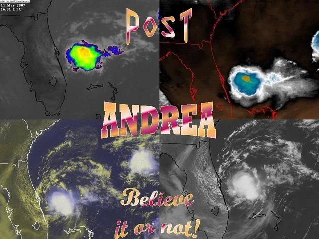
POST-ANDREA:

TD #4, 2000:

UHHMM, something is wrong here. The bottom one is a depression, but the top one is not. Both have a strong low pressure system, but one is almost devoid of convection, nevertheless, that's the depression, while Andrea is not.
By the way, almost in the same location!!!
TD #4, 2000:
Code: Select all
Table 1. Preliminary Best Track - Tropical Depression Four, 8-11 August 2000.  Date/Time
(UTC) Position Pressure
(mb) Wind Speed
(kt) Stage
Lat. (°N) Lon. (°W)
08 / 1200 28.2 74.2 1011 30 tropical depression
08 / 1800 28.1 75.1 1010 30 "
09 / 0000 28.0 76.0 1010 30 "
09 / 0600 27.9 76.8 1010 30 "
09 / 1200 27.9 77.4 1010 30 "
09 / 1800 27.9 77.9 1010 30 "
10 / 0000 28.0 78.6 1009 30 "
10 / 0600 28.3 79.3 1010 30 "
10 / 1200 28.7 78.9 1010 30 "
10 / 1800 28.9 78.3 1011 25 "
11 / 0000 29.2 77.8 1011 25 "
11 / 0600 29.4 77.2 1012 25 "
11 / 1200 29.6 76.5 1013 25 "

10 / 0000 28.0 78.6 1009 30 minimum pressure
UHHMM, something is wrong here. The bottom one is a depression, but the top one is not. Both have a strong low pressure system, but one is almost devoid of convection, nevertheless, that's the depression, while Andrea is not.
By the way, almost in the same location!!!
0 likes
I do not think she will be hanging around much longer,it comes from the West
http://www.atmos.washington.edu/~ovens/ ... nhanced+12
http://www.atmos.washington.edu/~ovens/ ... nhanced+12
0 likes
-
HURAKAN
- Professional-Met
- Posts: 46086
- Age: 38
- Joined: Thu May 20, 2004 4:34 pm
- Location: Key West, FL
- Contact:
SW N ATLC...
REMNANT OF ANDREA CONTINUES TO CHURN OFF THE NE FLORIDA COAST
NEAR 29N80W. A PULSE OF CONVECTION WAS FLARING NEAR THE CENTER
OF THIS SYSTEM THIS MORNING...BUT IS DISSIPATING CURRENTLY. A
MORNING QUIKSCAT PASS SHOWED WINDS UP TO 30 KT ON THE SE
QUADRANT OF ANDREA IN THE CONVECTION. OBSERVATIONS FROM 41010
AND 41009 AS WELL AS QUIKSCAT DATA SHOW 20 TO 25 KT AROUND THE
SYSTEM. BUOY 41009 WAS REPORTING A 1007 MB PRES AS WELL JUST W
OF THE CENTER. JUDGING FROM COASTAL RADAR IMAGERY...THE CENTER
APPEARS TO STILL BE DRIFTING SLOWLY S. HOWEVER...SHORT WAVE
ENERGY DIGGING THROUGH THE OHIO VALLEY WILL PUSH OFF THE MID
ATLANTIC STATES TOMORROW. THIS WILL PROMPT A COLD FRONT INTO THE
WATERS OFF NE FLORIDA AND N OF THE BAHAMAS BY SUN. AS A
RESULT...THE LOW IS PROGGED TO LIFT OUT TO THE NE STARTING
TONIGHT. SEAS WILL REMAIN NEAR THE 9 TO 10 FT RANGE FOR THE MOST
PART AROUND THE LOW TODAY...THEN DIMINISH AS THE LOW MOVES OUT
OF THE AREA THROUGH SAT. WINDS AND SEAS WILL PICK UP BEHIND THE
FRONT STARTING SUN NIGHT.
http://www.nhc.noaa.gov/text/MIAMIMATS.shtml?
No mention of possible re-development.
0 likes

-
JonathanBelles
- Professional-Met
- Posts: 11430
- Age: 35
- Joined: Sat Dec 24, 2005 9:00 pm
- Location: School: Florida State University (Tallahassee, FL) Home: St. Petersburg, Florida
- Contact:
Andrea may have taken a life:
Holly Hill surfer drowns after taking on 'gigantic wave' in New Smyrna Beach
Tanya Caldwell | Sentinel Staff Writer
Posted May 9, 2007, 3:31 PM EDT
Beach officials have identified the surfer who drowned in New Smyrna Beach today.
Scott Kevin Williams, a 32-year-old man from Holly Hill, died after he took on a "gigantic wave" and wiped out, said Capt. Scott Petersohn, a spokesman for the Volusia County Beach Patrol.
Williams was one of the hundreds of surfers on the beach this morning who took advantage of the 6- to 8-foot waves that are coming in because of Subtropical Storm Andrea, Petersohn said.
"The wave kind of gobbled him up, he wiped out and he basically drowned," Petersohn said.
Williams was still leashed to his board as his buddies pulled him ashore about 10:30 a.m., Petersohn said. He was rushed to Bert Fish Memorial Hospital, where he was pronounced dead.
Investigators think Williams may have hit his head on the board, Petersohn said. They won't know for sure until an autopsy is completed.
The drowning happened near the Flagler Avenue beach approach, one of the main approaches, Petersohn said. The beach remains open for beachgoers, who have been taking advantage of the waves all day, he said.
"The waves are unbelievable. It doesn't get like this very often," Petersohn said. "The surfers hold their breath, waiting for days like this."
But when those days come, Petersohn said, those surfers have to be careful.
"A 6- to 8-foot wave is fun to surf on," he said, "but they're really, really powerful."
http://www.orlandosentinel.com/news/loc ... -headlines
0 likes
Who is online
Users browsing this forum: Google Adsense [Bot] and 62 guests