And the GFS takes a system across so. Florida. Lots of agreement not just the NAM
http://moe.met.fsu.edu/cgi-bin/gfstc2.c ... =Animation
Tropical Development at Bahamas / GOM in comming days?
Moderator: S2k Moderators
Forum rules

The posts in this forum are NOT official forecasts and should not be used as such. They are just the opinion of the poster and may or may not be backed by sound meteorological data. They are NOT endorsed by any professional institution or STORM2K. For official information, please refer to products from the National Hurricane Center and National Weather Service.

Re: Tropical Development at Bahamas / GOM in comming days?
caneman wrote:06Z UKMET showing some low pressure off the West tip of Cuba
http://moe.met.fsu.edu/cgi-bin/ukmtc2.c ... =Animation
And interestingly enough, ol' Karen appears to be around too..
0 likes
-
caneman
Re: Tropical Development at Bahamas / GOM in comming days?
Yeah Karen is in the NOGAPS run too but as a significant event and as a minor event in the GFS run.
0 likes
-
jlauderdal
- S2K Supporter

- Posts: 7240
- Joined: Wed May 19, 2004 5:46 am
- Location: NE Fort Lauderdale
- Contact:
Re:
Tampa Bay Hurricane wrote:Heaviest rains over southeast florida
right now...
on and off lightning since midnight, made for some great sleeping in SE florida. A plant blew over by the pool so i guess you could say we have had tropical activity this season.
0 likes


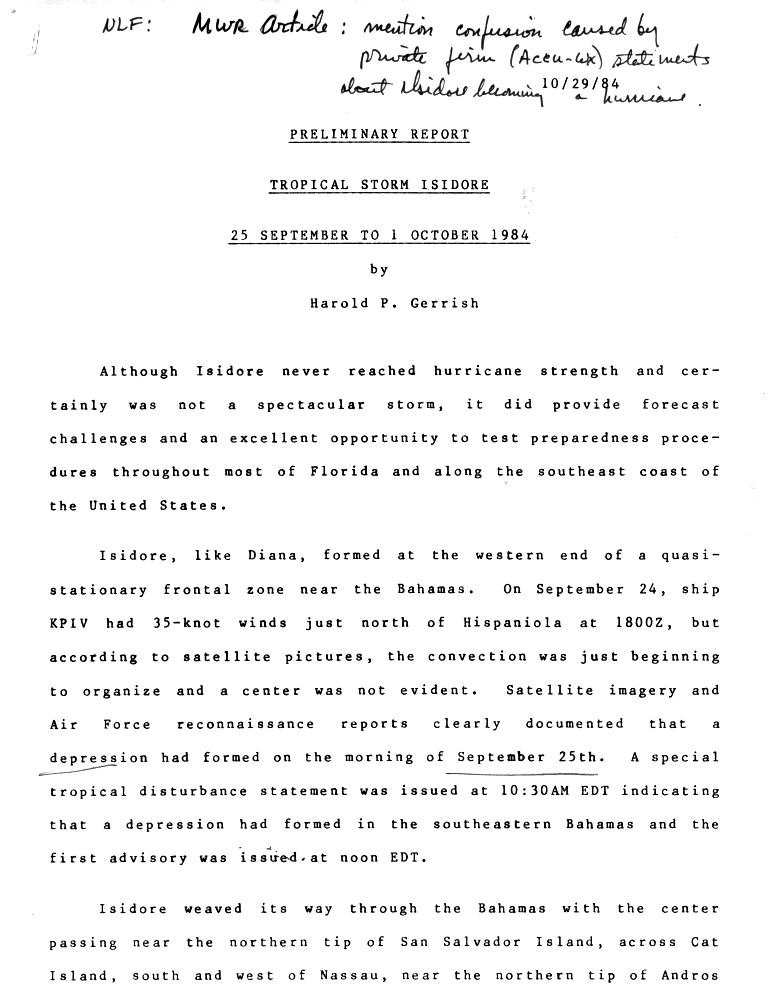
This system reminds me of tropical storm isidore in 1985. Read the report from NHC and the Note at the top of the page regarding confusion about "hurricane" caused by private entity "accu-weather"
http://www.nhc.noaa.gov/archive/storm_w ... elim01.gif
http://www.nhc.noaa.gov/archive/storm_w ... elim01.gif
0 likes
-
hurricanetrack

- HurricaneTrack.com

- Posts: 1781
- Joined: Tue Dec 02, 2003 10:46 pm
- Location: Wilmington, NC
- Contact:
-
Cryomaniac
- Category 5
- Posts: 1289
- Joined: Tue Aug 15, 2006 2:26 pm
- Location: Newark, Nottinghamshire, UK
- Contact:
Re:
Vortex wrote:Note at the top of the page regarding confusion about "hurricane" caused by private entity "accu-weather"
http://www.nhc.noaa.gov/archive/storm_w ... elim01.gif
Well, that shows nothings changed in 22 years...
0 likes

Re: Tropical Development at Bahamas / GOM in comming days?
Looks like another wet and sloppy system similar to TD 10 is going to form in the Bahamas and slowly retrograde west into the GOM. We may see this low track evolve a little more toward the north and perhaps east with time based on the 06Z NAM (and based on what eventually happened with TD 10) - I think the NAM did very well with the TD 10 setup although it was overdone strength wise - a bias that model has. I see a small twist near 23N-74W this morning and I would look for eventual low pressure to form somewhere around here. The ULL is currently off the SE FL coast. While most of the peninsula missed out on the rain with TD 10 (except NE FL where 5-10 inches fell) - perhaps it will be different this time. The convective mass is quite large east of FL. Overall, I see a weak, sheared subtropical low form with slow conversion into a tropical cyclone in the GOM.
0 likes
-
cycloneye

- Admin

- Posts: 149283
- Age: 69
- Joined: Thu Oct 10, 2002 10:54 am
- Location: San Juan, Puerto Rico
Re: Tropical Development at Bahamas / GOM in comming days?
Steve Lyons said in the 8:50 AM Tropical Update,that one low may form east of SC and move NE,and the other in the EGOM moving west from the upper low.
In other words,this may start subtropical like TD 10 was.The difference is that TD 10 was more north than where this will be and as Mark said,it may move thru the loop current.
In other words,this may start subtropical like TD 10 was.The difference is that TD 10 was more north than where this will be and as Mark said,it may move thru the loop current.
0 likes
-
Portastorm

- Storm2k Moderator

- Posts: 9954
- Age: 63
- Joined: Fri Jul 11, 2003 9:16 am
- Location: Round Rock, TX
- Contact:
Re: Tropical Development at Bahamas / GOM in comming days?
I know one thing ... should the Euro verify ... parts of south/east Texas would see a tropical low and the season's first strong cold front combining for some Biblical rain amounts next weekend.
http://weather.cod.edu/forecast/ECMWF/ecmwf_850_temp_144.gif
http://weather.cod.edu/forecast/ECMWF/ecmwf_850_temp_144.gif
0 likes
Re: Tropical Development at Bahamas / GOM in comming days?
cycloneye wrote:Steve Lyons said in the 8:50 AM Tropical Update,that one low may form east of SC and move NE,and the other in the EGOM moving west from the upper low.
In other words,this may start subtropical like TD 10 was.The difference is that TD 10 was more north than where this will be and as Mark said,it may move thru the loop current.
Dr Lyon's is going with the GFS solution which may happen but I think the bulk of the energy will retrograde west. Nearly all of the other models show this. While it looks like this low will travel more south, certainly further south than TD 10, the same shear monster will be with it due to the presence of the ULL migrating with it. If it travels over more GOM real estate though than TD 10, I agree it has a better chance of full development into a tropical cyclone.
0 likes
-
wxman57

- Moderator-Pro Met

- Posts: 23172
- Age: 68
- Joined: Sat Jun 21, 2003 8:06 pm
- Location: Houston, TX (southwest)
Re: Tropical Development at Bahamas / GOM in comming days?
For the past week, the ECMWF has been showing some kind of low development in the SE Gulf or NW Caribbean over the next 2-3 days. Initially, I thought the ECMWF was picking up on a tropical cyclone developing as the ridge builds over the east coast. But a check of the upper-level winds reveals a setup very similar to (or exactly like) TD 10. What the models see is a large/strong upper-level low drifting westward across the Gulf over the next 5 days. Winds aloft in the 50-70 kt range around the low. NOT an environment suitable for tropical development. Take a look at the image below valid 1am Wednesday. Note the position of the surface low (yellow contours) in the central Gulf then look at the 200mb winds (pink barbs) of 50-70 kts around the upper low. That's NOT a tropical low, it's subtropical. Such a strong upper-level low could allow for a weak surface low to form, but not a strong TS or a hurricane.
Looking at the image above, it appears that a weak tropical wave is interacting with that frontal boundary across the Bahamas and the whole mess will move westward into the Gulf over the next few days beneath a strong upper-level low. All the models see basically the same thing. With the pattern very similar to the TD 10 setup, we might expect a similar development at the surface. Like with TD 10, the models indicate a surface low forming and tracking along 25N-26N Tue/Wed and landfall near the upper TX or SW LA coast Friday. With TD 10, we saw that there were several surface lows fighting for survival as the system moved into the eastern Gulf. The northernmost low won out and landfall was much farther east (FL) vs. TX. Will the same thing happen again? Same setup, similar outcome?
I think there's a great potential surface low development in the SE Gulf Tuesday with the caveat that upper-level winds are not favorable for tropical development. A non-tropical low will likely form along the frontal boundary near the Bahamas over the next 24-48 hours then track west across the Gulf Tue-Friday, producing gusty wind in squalls. Conditions aloft are not favorable for hurricane development or even strong TS development, but the low could be classified as a subtropical depression or even a weak subtropical storm by Wednesday or Thursday in the central or north-central Gulf. Winds most likely in the 25-45 mph range. It should move inland into the northern Gulf coast on Friday somewhere between the upper TX coast and MS/AL, depending upon where the low center forms. It does look like this track will be a bit west of TD 10’s.
0 likes
-
Typhoon_Willie

- Category 5
- Posts: 1042
- Joined: Mon Jun 09, 2003 3:19 pm
- Location: Greenacres City, Florida
Re: Tropical Development at Bahamas / GOM in comming days?
Looks like to me that there is a low spinning up just south of Grand Bahama Island on this visible loop.
0 likes
-
cycloneye
- Admin
- Posts: 149283
- Age: 69
- Joined: Thu Oct 10, 2002 10:54 am
- Location: San Juan, Puerto Rico
Re: Tropical Development at Bahamas / GOM in comming days?
57,as always another great summary of those that you do to analize what will occur.A question,Do you think that this system being more south than TD 10 was,it may move over the loop current and transition to tropical more rapidly? Or the upper winds will cancel what the loop current may do?
0 likes
-
wxman57
- Moderator-Pro Met
- Posts: 23172
- Age: 68
- Joined: Sat Jun 21, 2003 8:06 pm
- Location: Houston, TX (southwest)
Re: Tropical Development at Bahamas / GOM in comming days?
cycloneye wrote:57,as always another great summary of those that you do to analize what will occur.A question,Do you think that this system being more south than TD 10 was,it may move over the loop current and transition to tropical more rapidly? Or the upper winds will cancel what the loop current may do?
Though it may move/track a bit farther south and over the loop current, models indicate 50-70kt winds aloft around the low as it does so. Even if the water was boiling beneath it, the low would have a hard time intensifying very quickly with that kind of upper-air environment. Could be stronger than TD 10, maybe an STS. It all depends on how quickly the surface low can form and whether we have 1 or 2 other lows fighting it out this time for dominance.
0 likes
-
Ed Mahmoud
Re: Tropical Development at Bahamas / GOM in comming days?
wxman57- GFS would appear to show dramatic reversal in shear (6Z run) near possible Gulf system of Louisiana about Friday. Although the gradient is rather sharp with the shear, and the low would have to be positioned right...

Too soon to tell, perhaps, in my petroleum engineering opinion (ie, amateur weather opinion)
Shear loop
Too soon to tell, perhaps, in my petroleum engineering opinion (ie, amateur weather opinion)
Shear loop
0 likes
-
Typhoon_Willie
- Category 5
- Posts: 1042
- Joined: Mon Jun 09, 2003 3:19 pm
- Location: Greenacres City, Florida
Re: Tropical Development at Bahamas / GOM in comming days?
How does the system near Grand Bahama look?
0 likes
Who is online
Users browsing this forum: No registered users and 87 guests