2024 Indicators: SST's, MSLP, Shear, SAL, Steering, Instability (Day 16+ Climate Models)
Moderator: S2k Moderators
Forum rules

The posts in this forum are NOT official forecasts and should not be used as such. They are just the opinion of the poster and may or may not be backed by sound meteorological data. They are NOT endorsed by any professional institution or STORM2K. For official information, please refer to products from the National Hurricane Center and National Weather Service.
-
cycloneye

- Admin

- Posts: 149261
- Age: 69
- Joined: Thu Oct 10, 2002 10:54 am
- Location: San Juan, Puerto Rico
Re: 2024 Indicators: SST's, MSLP, Shear, SAL, Steering, Instability (Day 16+ Climate Models)
Only going to say= September is September.
4 likes
Visit the Caribbean-Central America Weather Thread where you can find at first post web cams,radars
and observations from Caribbean basin members Click Here
and observations from Caribbean basin members Click Here
-
Category5Kaiju

- Category 5

- Posts: 4330
- Joined: Thu Dec 24, 2020 12:45 pm
- Location: Seattle and Phoenix
Re: 2024 Indicators: SST's, MSLP, Shear, SAL, Steering, Instability (Day 16+ Climate Models)
You know, I took a break from tracking the tropics on the first day of this month with there not really being anything to watch at that time.
Merely 6 days later, here I am, watching the news headline that there are now multiple areas in the Atlantic that are trying to develop (all of which have moderate or higher chances of forming). So...I'm back. Time to begin tracking 2024 again.
Anyways, my point is...September is peak hurricane season for a reason. What we saw with Beryl was highly unusual, but I sincerely had my doubts that that was going to be the only major storm of the season and that this season was going to basically wind down in mid-August. With models suggesting that at least one of the AOIs in the MDR could become a decent hurricane....we're definitely not done with this season. Looks like it has more in store for us. We'll see how the story unfolds next.
5 likes
Unless explicitly stated, all info in my posts is based on my own opinions and observations. Tropical storms and hurricanes can be extremely dangerous. Refer to an accredited weather research agency or meteorologist if you need to make serious decisions regarding an approaching storm.

Re: 2024 Indicators: SST's, MSLP, Shear, SAL, Steering, Instability (Day 16+ Climate Models)
In a nut shell, I think the balance of this season will display a sputtering recovery that might approach our yearly normal by the end of September and October. The net outcome will probably settle close to normal in terms of storm numbers and major hurricanes. I am skeptical to believe that whatever has plagued the Atlantic during the last month will suddenly self-correct over a few days. Thats the reason why I remain reluctant to assume that just because global models are becoming a little more deliberate & consistent, that the environment has quickly become quite favorable for genesis.. At the same time it just seems more reasonable then not, to think that a slowly shifting background state, a slight ebbing closer to La Nina, and some eventuality of the MJO slowly shifting to a less unfavorable position would permit a tropical basin during its peak climo cycle to produce some storms. Everything I thought I knew regarding locations of genesis, predominant storm tracks or largely higher storm intensities for the remainder of the season feels like a crap shoot however.
Maybe the light switch really WILL turn on in the next few days but I don't think it's going to quite feel like it. Instead it may feel more like a reluctant jump start of an old barn kept Chevy that hasn't been started in years. It's still alive and the car makes it to the street but that engine is popping & sputtering like it's starved for higher higher octane.
Maybe the light switch really WILL turn on in the next few days but I don't think it's going to quite feel like it. Instead it may feel more like a reluctant jump start of an old barn kept Chevy that hasn't been started in years. It's still alive and the car makes it to the street but that engine is popping & sputtering like it's starved for higher higher octane.
0 likes
Andy D
(For official information, please refer to the NHC and NWS products.)
(For official information, please refer to the NHC and NWS products.)
-
SFLcane

- S2K Supporter

- Posts: 10281
- Age: 48
- Joined: Sat Jun 05, 2010 1:44 pm
- Location: Lake Worth Florida
Re: 2024 Indicators: SST's, MSLP, Shear, SAL, Steering, Instability (Day 16+ Climate Models)
Really feel we could be in for one heck of an Oct in the caribbean as it continues to be illustrated by the very long gefs. We shall see!
1 likes
-
tolakram
- Admin
- Posts: 20178
- Age: 62
- Joined: Sun Aug 27, 2006 8:23 pm
- Location: Florence, KY (name is Mark)
Re: 2024 Indicators: SST's, MSLP, Shear, SAL, Steering, Instability (Day 16+ Climate Models)
We talked about epic bust, but what if this season ends up being close to the predicted numbers? I don't think it will, but the models have had such a tough time predicting just 5 days out I'm not sure if we'll even be able to predict an uptick in activity until it happens.
7 likes
M a r k
- - - - -
Join us in chat: Storm2K Chatroom Invite. Android and IOS apps also available.
The posts in this forum are NOT official forecasts and should not be used as such. Posts are NOT endorsed by any professional institution or STORM2K.org. For official information and forecasts, please refer to NHC and NWS products.
-
SFLcane
- S2K Supporter
- Posts: 10281
- Age: 48
- Joined: Sat Jun 05, 2010 1:44 pm
- Location: Lake Worth Florida
Re: 2024 Indicators: SST's, MSLP, Shear, SAL, Steering, Instability (Day 16+ Climate Models)
tolakram wrote:We talked about epic bust, but what if this season ends up being close to the predicted numbers? I don't think it will, but the models have had such a tough time predicting just 5 days out I'm not sure if we'll even be able to predict an uptick in activity until it happens.
Sure thing i agree 100% for me i careless about ace or numbers predicted its all about " impacts " which very storm so far this season has had.
0 likes
-
toad strangler

- S2K Supporter
- Posts: 4546
- Joined: Sun Jul 28, 2013 3:09 pm
- Location: Earth
- Contact:
Re: 2024 Indicators: SST's, MSLP, Shear, SAL, Steering, Instability (Day 16+ Climate Models)
SFLcane wrote:tolakram wrote:We talked about epic bust, but what if this season ends up being close to the predicted numbers? I don't think it will, but the models have had such a tough time predicting just 5 days out I'm not sure if we'll even be able to predict an uptick in activity until it happens.
Sure thing i agree 100% for me i careless about ace or numbers predicted its all about " impacts " which very storm so far this season has had.
Yes sir. Looking at the possible THIRD hurricane landfall in the CONUS now with SIX. Plus Ernesto gave PR and Bermuda a good scare. So impacts have been, and look to be, pretty impactful.
2 likes
My Weather Station
https://www.wunderground.com/dashboard/pws/KFLPORTS603
https://www.wunderground.com/dashboard/pws/KFLPORTS603
-
SFLcane
- S2K Supporter
- Posts: 10281
- Age: 48
- Joined: Sat Jun 05, 2010 1:44 pm
- Location: Lake Worth Florida
Re: 2024 Indicators: SST's, MSLP, Shear, SAL, Steering, Instability (Day 16+ Climate Models)
toad strangler wrote:SFLcane wrote:tolakram wrote:We talked about epic bust, but what if this season ends up being close to the predicted numbers? I don't think it will, but the models have had such a tough time predicting just 5 days out I'm not sure if we'll even be able to predict an uptick in activity until it happens.
Sure thing i agree 100% for me i careless about ace or numbers predicted its all about " impacts " which very storm so far this season has had.
Yes sir. Looking at the possible THIRD hurricane landfall in the CONUS now with SIX. Plus Ernesto gave PR and Bermuda a good scare. So impacts have been, and look to be, pretty impactful.
Likely more to come long way to go in this hurricane season.
0 likes
-
SFLcane
- S2K Supporter
- Posts: 10281
- Age: 48
- Joined: Sat Jun 05, 2010 1:44 pm
- Location: Lake Worth Florida
Re: 2024 Indicators: SST's, MSLP, Shear, SAL, Steering, Instability (Day 16+ Climate Models)
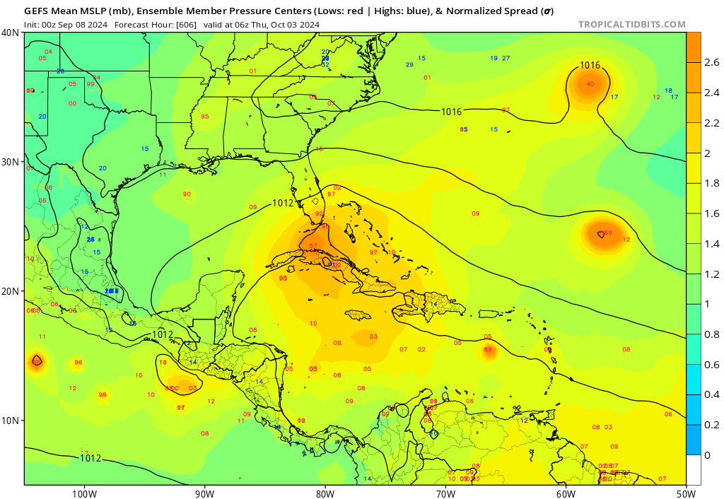
SFLcane wrote:Really feel we could be in for one heck of an Oct in the caribbean as it continues to be illustrated by the very long gefs. We shall see!
https://i.postimg.cc/KjG2qyxn/gs.png
Look at the NW caribbean.
4 likes
Re: 2024 Indicators: SST's, MSLP, Shear, SAL, Steering, Instability (Day 16+ Climate Models)
SFLcane wrote:SFLcane wrote:Really feel we could be in for one heck of an Oct in the caribbean as it continues to be illustrated by the very long gefs. We shall see!
https://i.postimg.cc/KjG2qyxn/gs.png
Look at the NW caribbean.Lets hope nothing gets going down there.
https://i.postimg.cc/kgknvZZ5/nnn.jpg
YUP! And in spite of the abbreviated season, "something" is gonna come out of that boiler plate south of Cuba before it's all said and done.
1 likes
Andy D
(For official information, please refer to the NHC and NWS products.)
(For official information, please refer to the NHC and NWS products.)
Re: 2024 Indicators: SST's, MSLP, Shear, SAL, Steering, Instability (Day 16+ Climate Models)
tolakram wrote:We talked about epic bust, but what if this season ends up being close to the predicted numbers? I don't think it will, but the models have had such a tough time predicting just 5 days out I'm not sure if we'll even be able to predict an uptick in activity until it happens.
Case in point; just take a look at the Atlantic basin this morning. None may ultimately develop but 3 tropical cyclones could just as well. In fact, one not even mentioned by NHC at around 52W could before those being tracked further east. I guess a sudden flurry would truly verify the switch has flipped.
1 likes
Andy D
(For official information, please refer to the NHC and NWS products.)
(For official information, please refer to the NHC and NWS products.)

Re: 2024 Indicators: SST's, MSLP, Shear, SAL, Steering, Instability (Day 16+ Climate Models)
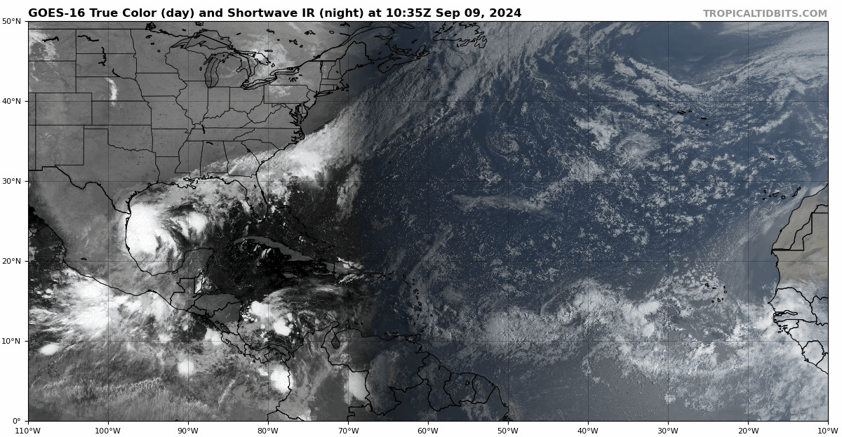
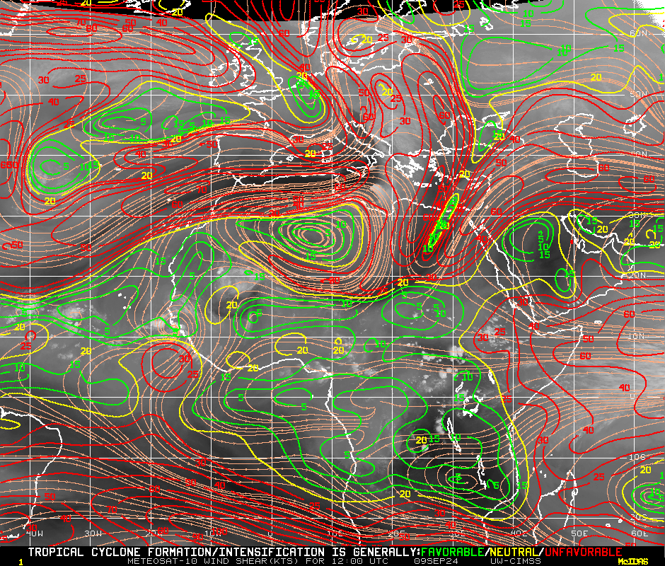
Suddenly, the tropical Atlantic doesn't feel bone dry and stable anymore. In addition to Francine, there is a chain of convectively active disturbances and vigorous vorts in the MDR, from Africa all the way to Lesser Antilles.
If anything, even if none of them develop -- which is a big if -- it might be more aptly blamed on too many disturbances, rather than too few thunderstorms. It's possible that because everyone wants to develop (with the exception of the wave near Lesser Antilles), nothing can consolidate. This is what models runs have sometimes shown for a few (occasionally all) of the MDR disturbances.
Reminder: We're still in a suppressed MJO phase.
1 likes
TC naming lists: retirements and intensity
Most aggressive Advisory #1's in North Atlantic (cr. kevin for starting the list)
Most aggressive Advisory #1's in North Atlantic (cr. kevin for starting the list)

Re: 2024 Indicators: SST's, MSLP, Shear, SAL, Steering, Instability (Day 16+ Climate Models)
Teban54 wrote:Suddenly, the tropical Atlantic doesn't feel bone dry and stable anymore. In addition to Francine, there is a chain of convectively active disturbances and vigorous vorts in the MDR, from Africa all the way to Lesser Antilles.
If anything, even if none of them develop -- which is a big if -- it might be more aptly blamed on too many disturbances, rather than too few thunderstorms. It's possible that because everyone wants to develop (with the exception of the wave near Lesser Antilles), nothing can consolidate. This is what models runs have sometimes shown for a few (occasionally all) of the MDR disturbances.
Reminder: We're still in a suppressed MJO phase.
https://i.postimg.cc/0QhTMKzn/goes16-truecolor-atl.gif
Yeah it’s still a tangled mess out east, probably because the monsoon/AEJ is still very strong. Not sure if we’ll get anything significant out of those disturbances because either they fade out and die or go pretty north very quickly on the models.
0 likes
Irene '11 Sandy '12 Hermine '16 5/15/2018 Derecho Fay '20 Isaias '20 Elsa '21 Henri '21 Ida '21
I am only a meteorology enthusiast who knows a decent amount about tropical cyclones. Look to the professional mets, the NHC, or your local weather office for the best information.
I am only a meteorology enthusiast who knows a decent amount about tropical cyclones. Look to the professional mets, the NHC, or your local weather office for the best information.
Re: 2024 Indicators: SST's, MSLP, Shear, SAL, Steering, Instability (Day 16+ Climate Models)
aspen wrote:Teban54 wrote:Suddenly, the tropical Atlantic doesn't feel bone dry and stable anymore. In addition to Francine, there is a chain of convectively active disturbances and vigorous vorts in the MDR, from Africa all the way to Lesser Antilles.
If anything, even if none of them develop -- which is a big if -- it might be more aptly blamed on too many disturbances, rather than too few thunderstorms. It's possible that because everyone wants to develop (with the exception of the wave near Lesser Antilles), nothing can consolidate. This is what models runs have sometimes shown for a few (occasionally all) of the MDR disturbances.
Reminder: We're still in a suppressed MJO phase.
https://i.postimg.cc/0QhTMKzn/goes16-truecolor-atl.gif
Yeah it’s still a tangled mess out east, probably because the monsoon/AEJ is still very strong. Not sure if we’ll get anything significant out of those disturbances because either they fade out and die or go pretty north very quickly on the models.
AEJ-induced shear in the eastern Atlantic has decreased from 40 kts earlier to 0-20 kt today, however (with the exception of a small blob that may be wave-induced). Whether that's solely due to the emergence of the wave today remains to be seen; however, models generally show 0-20 kts of shear moving forward, and the "zero-shear zone" also moves south to be directly within the MDR.
3 likes
TC naming lists: retirements and intensity
Most aggressive Advisory #1's in North Atlantic (cr. kevin for starting the list)
Most aggressive Advisory #1's in North Atlantic (cr. kevin for starting the list)

Re: 2024 Indicators: SST's, MSLP, Shear, SAL, Steering, Instability (Day 16+ Climate Models)
In addition to being climo peak, it appears that today this season's ACE total will be overtaken by the 1991-2020 average.
0 likes
Kendall -> SLO -> PBC
Memorable Storms: Katrina (for its Florida landfall...) Wilma Matthew Irma
Memorable Storms: Katrina (for its Florida landfall...) Wilma Matthew Irma
-
MarioProtVI
- Category 5
- Posts: 1034
- Age: 24
- Joined: Sun Sep 29, 2019 7:33 pm
- Location: New Jersey
Re: 2024 Indicators: SST's, MSLP, Shear, SAL, Steering, Instability (Day 16+ Climate Models)
Ubuntwo wrote:In addition to being climo peak, it appears that today this season's ACE total will be overtaken by the 1991-2020 average.
For a few days and then it looks like it will jump back above if the 30/70 pans out as a long tracker.
0 likes

Re: 2024 Indicators: SST's, MSLP, Shear, SAL, Steering, Instability (Day 16+ Climate Models)
MarioProtVI wrote:Ubuntwo wrote:In addition to being climo peak, it appears that today this season's ACE total will be overtaken by the 1991-2020 average.
For a few days and then it looks like it will jump back above if the 30/70 pans out as a long tracker.
Models have been backing away hard from development
0 likes
The above post is not official and should not be used as such. It is the opinion of the poster and may or may not be backed by sound meteorological data. It is not endorsed by any professional institution or storm2k.org. For official information, please refer to the NHC and NWS products.
Re: 2024 Indicators: SST's, MSLP, Shear, SAL, Steering, Instability (Day 16+ Climate Models)
SFLcane wrote:https://i.postimg.cc/ry02bpLw/ggg.gif
Long way off but that says Florida Panhandle all over it. One thing for certain is that the GOM seems to be the hot spot this season.
0 likes
Andy D
(For official information, please refer to the NHC and NWS products.)
(For official information, please refer to the NHC and NWS products.)
-
MarioProtVI
- Category 5
- Posts: 1034
- Age: 24
- Joined: Sun Sep 29, 2019 7:33 pm
- Location: New Jersey
Re: 2024 Indicators: SST's, MSLP, Shear, SAL, Steering, Instability (Day 16+ Climate Models)
Hammy wrote:MarioProtVI wrote:Ubuntwo wrote:In addition to being climo peak, it appears that today this season's ACE total will be overtaken by the 1991-2020 average.
For a few days and then it looks like it will jump back above if the 30/70 pans out as a long tracker.
Models have been backing away hard from development
It’s far more likely they are struggling to resolve the MT breakdown and those that are backing off on development are in fact just stringing the system out way too fast. In fact, the latest 12z EURO still shows a strong system, and the ICON (which correctly nailed Francine FWIW) also still shows a strengthening tropical storm heading west. GFS has a notorious string out bias in cases like these so I’m inclined to ignore the oper and pay more attention to the ensembles which are far more active.
1 likes
Who is online
Users browsing this forum: kevin, mixedDanilo.E and 66 guests