Possible NW Gulf Development Late This Week?

This is the general tropical discussion area. Anyone can take their shot at predicting a storms path.

Moderator: S2k Moderators

Forum rules

The posts in this forum are NOT official forecasts and should not be used as such. They are just the opinion of the poster and may or may not be backed by sound meteorological data. They are NOT endorsed by any professional institution or STORM2K. For official information, please refer to products from the National Hurricane Center and National Weather Service.

Help Support Storm2K
Message
Author
User avatar
vbhoutex
Storm2k Executive
Storm2k Executive
Posts: 29113
Age: 73
Joined: Wed Oct 09, 2002 11:31 pm
Location: Cypress, TX
Contact:

Re: Possible NW Gulf Development Late This Week?

#261 Postby vbhoutex » Fri Sep 11, 2009 3:34 pm

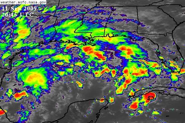
djones65 wrote:Surface pressures will always fluctuate up and down diurnally.
I look at 24 hour trends to determine whether pressures are rising or falling. Just because a synoptic report may show a rising pressure at the observation time is not that important to me unless it is during the time it should be falling diurnally. What I look at is to compare the pressures at 12 or 24 hour increments. Typically a pressure drop of greater than 3 mb in 24 hours is a good indicator of something possibly forming. Buoy 42020 50 miles southeast of Corpus Christi, TX shows a 24 hour pressure fall of 2.3 mb. At 1950UTC the pressure was 29.85" and same time yesterday it was 29.92"

With that being said I personally do not believe we will see a tropical cyclone develop out of this system. I do believe we will see a broad low pressure area with multiple vortices that will track north northeast into western and central Louisiana on Sunday. However, the upper level shear will be too strong to allow the system to become vertically aligned.

Very good analysis. I am throwing out the possibilities for discussion when I post like what I did above. IF a sfc low does form, as you stated there is almost no possibility of it becoming vertically stacked. I have not tried to look back over the last few days of pressures, but the pressures I am seeing appear a little lower than normal to me. The fact that they are falling now is imo normal. Time will tell if this is going to turn into a trend.
0 likes   

Sanibel
Category 5
Category 5
Posts: 10375
Joined: Mon Aug 30, 2004 11:06 pm
Location: Offshore SW Florida

Re: Possible NW Gulf Development Late This Week?

#262 Postby Sanibel » Fri Sep 11, 2009 3:43 pm

Nothing to rave about:


Image
0 likes   

User avatar
southerngale
Retired Staff
Retired Staff
Posts: 27418
Joined: Thu Oct 10, 2002 1:27 am
Location: Southeast Texas (Beaumont area)

#263 Postby southerngale » Fri Sep 11, 2009 3:47 pm

Unless I'm reading this wrong, the Euro continues to show the low (in whatever form that may be) go inland and then back out into the GOM. It's still on the map in 168 hours.

http://www.meteo.psu.edu/~gadomski/ECMWF_12z/ecmwfloop.html#picture
0 likes   

StormClouds63
Category 2
Category 2
Posts: 583
Age: 62
Joined: Tue May 13, 2008 11:56 am
Location: Southwest Louisiana

Re: Possible NW Gulf Development Late This Week?

#264 Postby StormClouds63 » Fri Sep 11, 2009 3:54 pm

Don't see much chance for significant development either. The still unknown is what specific area is going to receive the highest rainfall totals. Could be anywhere from SE/Central TX all the way east to MS/AL. Looks like SE LA really getting the brunt this afternoon.
0 likes   

Nederlander
S2K Supporter
S2K Supporter
Posts: 1250
Joined: Sat Jul 19, 2008 4:28 pm
Location: Conroe, TX

Re: Possible NW Gulf Development Late This Week?

#265 Postby Nederlander » Fri Sep 11, 2009 3:56 pm

StormClouds63 wrote:Don't see much chance for significant development either. The still unknown is what specific area is going to receive the highest rainfall totals. Could be anywhere from SE/Central TX all the way east to MS/AL. Looks like SE LA really getting the brunt this afternoon.


Yea its been pretty rain free here in Beaumont all day. Not quite the 80% coverage I was expecting. Pretty cloudy but thats about it.
0 likes   

bohaiboy
Tropical Depression
Tropical Depression
Posts: 86
Joined: Sat Aug 09, 2008 11:20 am

Re: Possible NW Gulf Development Late This Week?

#266 Postby bohaiboy » Fri Sep 11, 2009 4:00 pm

Remember the definition of rain coverage. Frank Billingsley here in Houston stated that that means that 80% of the viewing area will get measureable precipitation, not necessarily that the viewing area will get 80% coverage of measureable precip.
0 likes   

User avatar
lrak
S2K Supporter
S2K Supporter
Posts: 1770
Age: 58
Joined: Thu Jun 21, 2007 2:48 pm
Location: Corpus Christi, TX

Re: Possible NW Gulf Development Late This Week?

#267 Postby lrak » Fri Sep 11, 2009 4:11 pm

It appears that some sort of LLCenter is just west of CC Tx and is moving ESE and will be over water tonight. The satellite shows a UUGE rotation on the visible. Is this "rotation illusion" due to shear or an ULL? IMO if all this mess exits tonight, tomorrow might be interesting for SE TX and on east to LA?
0 likes   

User avatar
HURAKAN
Professional-Met
Professional-Met
Posts: 46086
Age: 38
Joined: Thu May 20, 2004 4:34 pm
Location: Key West, FL
Contact:

#268 Postby HURAKAN » Fri Sep 11, 2009 4:23 pm

Image

The gulf is hot
0 likes   

Frank P
S2K Supporter
S2K Supporter
Posts: 2776
Joined: Fri Aug 29, 2003 10:52 am
Location: Biloxi Beach, Ms
Contact:

Re:

#269 Postby Frank P » Fri Sep 11, 2009 4:29 pm

HURAKAN wrote:Image

The gulf is hot


We just got a nice little squall line come through here in the past hour.. wind blowing hard enough I had to go flip all my porch chairs upside down so they would fly all over the place.. first of any type tropical activity I've seen all year.. not much, but interesting while it lasted...
0 likes   

User avatar
wxman57
Moderator-Pro Met
Moderator-Pro Met
Posts: 22979
Age: 67
Joined: Sat Jun 21, 2003 8:06 pm
Location: Houston, TX (southwest)

Re: Possible NW Gulf Development Late This Week?

#270 Postby wxman57 » Fri Sep 11, 2009 4:48 pm

I think a weak low will form offshore Texas tomorrow. NHC may be more quick to call it a depression if it's impacting the offshore lease areas. However, conditions aloft are only marginally favorable for strengthening. It should move inland on Sunday, so not a lot of time to organize in a marginal environment. Still looks like a very heavy rainmaker for east TX/LA.

Here's a semi-current surface analysis/satellite. Surface trof not very evident, but pressures have fallen 2-3 millibars in 24 hours:

Image
0 likes   

weatherguy425
Tropical Storm
Tropical Storm
Posts: 180
Joined: Sun Aug 16, 2009 1:06 pm
Location: Houston, TX > Lubbock, TX > Savannah, GA
Contact:

Re: Possible NW Gulf Development Late This Week?

#271 Postby weatherguy425 » Fri Sep 11, 2009 4:51 pm

wxman57- when you say "east texas" do you think the houston metro could get in on some of the hefty rain totals?
0 likes   

User avatar
lrak
S2K Supporter
S2K Supporter
Posts: 1770
Age: 58
Joined: Thu Jun 21, 2007 2:48 pm
Location: Corpus Christi, TX

Re: Possible NW Gulf Development Late This Week?

#272 Postby lrak » Fri Sep 11, 2009 4:53 pm

Man if there were no shear :eek:
0 likes   

Stormcenter
S2K Supporter
S2K Supporter
Posts: 6684
Joined: Wed Sep 03, 2003 11:27 am
Location: Houston, TX

Re: Possible NW Gulf Development Late This Week?

#273 Postby Stormcenter » Fri Sep 11, 2009 4:55 pm

Thank goodness there is. :)

lrak wrote:Man if there were no shear :eek:
0 likes   

User avatar
wxman57
Moderator-Pro Met
Moderator-Pro Met
Posts: 22979
Age: 67
Joined: Sat Jun 21, 2003 8:06 pm
Location: Houston, TX (southwest)

Re: Possible NW Gulf Development Late This Week?

#274 Postby wxman57 » Fri Sep 11, 2009 4:55 pm

weatherguy425 wrote:wxman57- when you say "east texas" do you think the houston metro could get in on some of the hefty rain totals?


Certainly possible. We have the core of heaviest rain from Port Arthur to the mid LA coast now. I'd say Houston could see widespread 2-4 inches. In the core, 5-10 inches. Some areas could get 15-20" out of this system through Tuesday.
0 likes   

User avatar
Dionne
S2K Supporter
S2K Supporter
Posts: 1616
Age: 74
Joined: Mon Jan 02, 2006 8:51 am
Location: SW Mississippi....Alaska transplant via a Southern Belle.

Re: Possible NW Gulf Development Late This Week?

#275 Postby Dionne » Fri Sep 11, 2009 4:58 pm

We're just a few minutes away from the squall line moving northwest through SW Mississippi. It's heavy rain. We're gonna get wet tonight.

Watching the SW now. This could be interesting. Lots of moisture.
0 likes   

User avatar
cycloneye
Admin
Admin
Posts: 145366
Age: 68
Joined: Thu Oct 10, 2002 10:54 am
Location: San Juan, Puerto Rico

Re: Possible NW Gulf Development Late This Week?

#276 Postby cycloneye » Fri Sep 11, 2009 5:09 pm

The 18z surface analysis chart has a 1011 mb surface low in the WGOM.

Image

http://www.opc.ncep.noaa.gov/UA.shtml
0 likes   

JonathanBelles
Professional-Met
Professional-Met
Posts: 11430
Age: 35
Joined: Sat Dec 24, 2005 9:00 pm
Location: School: Florida State University (Tallahassee, FL) Home: St. Petersburg, Florida
Contact:

#277 Postby JonathanBelles » Fri Sep 11, 2009 5:22 pm

Getting rain coming in in bands now from the GOM.
0 likes   

attallaman

Re: Possible NW Gulf Development Late This Week?

#278 Postby attallaman » Fri Sep 11, 2009 6:12 pm

My local forecast on TWC this afternoon said an 80% chance of rain today, an 80% chance of rain tonight and a 90% chance of rain tomorrow. The rain has arrived.
0 likes   

Sanibel
Category 5
Category 5
Posts: 10375
Joined: Mon Aug 30, 2004 11:06 pm
Location: Offshore SW Florida

Re: Possible NW Gulf Development Late This Week?

#279 Postby Sanibel » Fri Sep 11, 2009 6:14 pm

Also have weak 'band' rains off Gulf here too.
0 likes   

CYCLONE MIKE
Category 5
Category 5
Posts: 2183
Joined: Tue Aug 31, 2004 6:04 pm
Location: Gonzales, LA

Re: Possible NW Gulf Development Late This Week?

#280 Postby CYCLONE MIKE » Fri Sep 11, 2009 6:16 pm

wxman57 wrote:I think a weak low will form offshore Texas tomorrow. NHC may be more quick to call it a depression if it's impacting the offshore lease areas. However, conditions aloft are only marginally favorable for strengthening. It should move inland on Sunday, so not a lot of time to organize in a marginal environment. Still looks like a very heavy rainmaker for east TX/LA.

Here's a semi-current surface analysis/satellite. Surface trof not very evident, but pressures have fallen 2-3 millibars in 24 hours:

Image


wxman, where are you thinking a low could form?
0 likes   


Return to “Talkin' Tropics”

Who is online

Users browsing this forum: ElectricStorm, Stratton23, USTropics and 46 guests