
Seasonal Indicators (Beyond Day 16): Instability / SST's / MSLP / Steering / Sal
Moderator: S2k Moderators
Forum rules

The posts in this forum are NOT official forecasts and should not be used as such. They are just the opinion of the poster and may or may not be backed by sound meteorological data. They are NOT endorsed by any professional institution or STORM2K. For official information, please refer to products from the National Hurricane Center and National Weather Service.
Re: 2016 indicators: Instability / SST's / MSLP / Steering / Sal
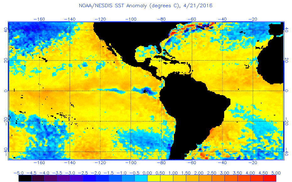
Today's update from NOAA site shows much warmer tropical MDR than CDAS's numbers.
0 likes
-
SFLcane

- S2K Supporter

- Posts: 10281
- Age: 48
- Joined: Sat Jun 05, 2010 1:44 pm
- Location: Lake Worth Florida
Re: 2016 indicators: Instability / SST's / MSLP / Steering / Sal
NDG if that keeps up Phil K might have to increase his numbers. Banking on some of those cold sst's in north atl to spread into mdr.
0 likes
-
WPBWeather

- S2K Supporter
- Posts: 535
- Age: 67
- Joined: Thu Jul 18, 2013 12:33 pm
Re: 2016 indicators: Instability / SST's / MSLP / Steering / Sal
SFLcane wrote:NDG if that keeps up Phil K might have to increase his numbers. Banking on some of those cold sst's in north atl to spread into mdr.
Careful where you bank! And I believe a number of folks will up their numbers when all is said and done.
0 likes
-
SFLcane
- S2K Supporter
- Posts: 10281
- Age: 48
- Joined: Sat Jun 05, 2010 1:44 pm
- Location: Lake Worth Florida
Re: 2016 indicators: Instability / SST's / MSLP / Steering / Sal
CSU is banking on the north atl sst's to move into the mdr. Per phil its not a good look for a busy season ahead.
0 likes
-
SFLcane
- S2K Supporter
- Posts: 10281
- Age: 48
- Joined: Sat Jun 05, 2010 1:44 pm
- Location: Lake Worth Florida
Re: 2016 indicators: Instability / SST's / MSLP / Steering / Sal
If levi's map are correct subsurface is quite cold so cooling maybe around the corner.
0 likes
-
WeatherEmperor
- S2K Supporter
- Posts: 4806
- Age: 42
- Joined: Thu Sep 04, 2003 2:54 pm
- Location: South Florida
Re: 2016 indicators: Instability / SST's / MSLP / Steering / Sal
Even more important than these warm atlantic sst temps is the warm sst temps in the Epac above the equator. So many are over looking this and its impact on atlantic activity. The little cold spot near the Epac equator is the emerging la nina but the warm waters above the equator from the west coast of central america up to the california coast are critical. This can cause tremendous wind shear over the Caribbean and portions of the Mdr. Remember folks sonething like this happened in 1983 and look how that turned out
0 likes
Re: 2016 indicators: Instability / SST's / MSLP / Steering / Sal
WeatherEmperor wrote:Even more important than these warm atlantic sst temps is the warm sst temps in the Epac above the equator. So many are over looking this and its impact on atlantic activity. The little cold spot near the Epac equator is the emerging la nina but the warm waters above the equator from the west coast of central america up to the california coast are critical. This can cause tremendous wind shear over the Caribbean and portions of the Mdr. Remember folks sonething like this happened in 1983 and look how that turned out
Believe it or not the SSTs north of the eastern Pacific equatorial waters, as you mention, were average at best during '83's hurricane season.
IMO, as I have been mentioning, the corp was Nino's 1+2 & sections of eastern Nino 3's boiling waters.


0 likes
-
WeatherEmperor
- S2K Supporter
- Posts: 4806
- Age: 42
- Joined: Thu Sep 04, 2003 2:54 pm
- Location: South Florida
Re: 2016 indicators: Instability / SST's / MSLP / Steering / Sal
@Ndg
You make a good point. When I mean similar to 1983 I mean in atmospheric profile not exact temperature profile. In fact, Csu is using 1983 and 1992 as analogs. Yes 1998 is also an analog but its the overall atmosphere that I believe will make this season not as active as some believe. Yes the Atlantic sst is warm but so is the Epac above the equator. Ok so naybe it wont shut down the Atlantic but it will hurt the Atlantic we cannot ignore that. Couple that with the higher than normal sea level pressures forecast across pretty much the entire Mdr by the Euro and you have a season that looks average at best despite the above normal Atkantic sst temps. The Euro wasnt wrong about high pressures last year and I dont see it being wrong this year either. Maybe if the Atlantic gets even warmer than it is now then we have to think about a more active Atlantic
You make a good point. When I mean similar to 1983 I mean in atmospheric profile not exact temperature profile. In fact, Csu is using 1983 and 1992 as analogs. Yes 1998 is also an analog but its the overall atmosphere that I believe will make this season not as active as some believe. Yes the Atlantic sst is warm but so is the Epac above the equator. Ok so naybe it wont shut down the Atlantic but it will hurt the Atlantic we cannot ignore that. Couple that with the higher than normal sea level pressures forecast across pretty much the entire Mdr by the Euro and you have a season that looks average at best despite the above normal Atkantic sst temps. The Euro wasnt wrong about high pressures last year and I dont see it being wrong this year either. Maybe if the Atlantic gets even warmer than it is now then we have to think about a more active Atlantic
0 likes
-
WPBWeather
- S2K Supporter
- Posts: 535
- Age: 67
- Joined: Thu Jul 18, 2013 12:33 pm
Re: 2016 indicators: Instability / SST's / MSLP / Steering / Sal
WeatherEmperor wrote:@Ndg
You make a good point. When I mean similar to 1983 I mean in atmospheric profile not exact temperature profile. In fact, Csu is using 1983 and 1992 as analogs. Yes 1998 is also an analog but its the overall atmosphere that I believe will make this season not as active as some believe. Yes the Atlantic sst is warm but so is the Epac above the equator. Ok so naybe it wont shut down the Atlantic but it will hurt the Atlantic we cannot ignore that. Couple that with the higher than normal sea level pressures forecast across pretty much the entire Mdr by the Euro and you have a season that looks average at best despite the above normal Atkantic sst temps. The Euro wasnt wrong about high pressures last year and I dont see it being wrong this year either. Maybe if the Atlantic gets even warmer than it is now then we have to think about a more active Atlantic
A wise tweet from two Pro Mets:
Michael Lowry @MichaelRLowry 10h10 hours ago
Odds of getting the flu: 13%. Odds of a hurricane landfall this year in FL: 49% (via @philklotzbach). Get your hurricane flu shot @Readygov
13 retweets 19 likes
Reply Retweet 13
Like 19
More
0 likes
-
cycloneye

- Admin

- Posts: 149405
- Age: 69
- Joined: Thu Oct 10, 2002 10:54 am
- Location: San Juan, Puerto Rico
Re: 2016 indicators: Instability / SST's / MSLP / Steering / Sal
The question is which updates more rapidly,NOAA graphics or the Levi CDAS.
0 likes
Visit the Caribbean-Central America Weather Thread where you can find at first post web cams,radars
and observations from Caribbean basin members Click Here
and observations from Caribbean basin members Click Here
-
SFLcane
- S2K Supporter
- Posts: 10281
- Age: 48
- Joined: Sat Jun 05, 2010 1:44 pm
- Location: Lake Worth Florida
Re: 2016 indicators: Instability / SST's / MSLP / Steering / Sal
Anyone got anything on these sst maps? Both paint a very different picture.
0 likes
-
wxman57

- Moderator-Pro Met

- Posts: 23173
- Age: 68
- Joined: Sat Jun 21, 2003 8:06 pm
- Location: Houston, TX (southwest)
Re: 2016 indicators: Instability / SST's / MSLP / Steering / Sal
That NOAA/NESDIS SST anomaly map looks quite odd. The NOAA/ESRL map below matches NCEP's, with a cool anomaly in the MDR.

0 likes
-
SFLcane
- S2K Supporter
- Posts: 10281
- Age: 48
- Joined: Sat Jun 05, 2010 1:44 pm
- Location: Lake Worth Florida
Re: 2016 indicators: Instability / SST's / MSLP / Steering / Sal
Ouch 57..well things continue to go downhill then. when its all said and done the active period of tc in Atl has ended. "Very ugly" look thus far across the basin for 2016. All points to a below average yr.
0 likes
-
cycloneye
- Admin
- Posts: 149405
- Age: 69
- Joined: Thu Oct 10, 2002 10:54 am
- Location: San Juan, Puerto Rico
Re: 2016 indicators: Instability / SST's / MSLP / Steering / Sal
SFLcane wrote:Ouch 57..well things continue to go downhill then. when its all said and done the active period of tc in Atl has ended. "Very ugly" look thus far across the basin for 2016. All points to a below average yr.
I guess you are going down from the 15/8/4 at S2K poll.
0 likes
Visit the Caribbean-Central America Weather Thread where you can find at first post web cams,radars
and observations from Caribbean basin members Click Here
and observations from Caribbean basin members Click Here
-
TropicalAnalystwx13

- Category 5

- Posts: 2109
- Age: 28
- Joined: Tue Jul 19, 2011 8:20 pm
- Location: Wilmington, NC
- Contact:
Re: 2016 indicators: Instability / SST's / MSLP / Steering / Sal
Ocean temperatures should be a neutral factor across the Main Development Region this year. The negative anomalies that have appeared are not surprising given the persistent +NAO we've seen. Moving forward, the NAO should transition to more Neutral or negative, allowing ocean temperatures to warm again.
With an active African Easterly Jet and strengthening La Nina, an average to slightly above average season is looking likely. An unexpected re-invigoration of El Nino is about the only thing that I see could yield a below-average season, whereas a dramatic shift in the SST configuration would be necessary for a hyperactive year.
With an active African Easterly Jet and strengthening La Nina, an average to slightly above average season is looking likely. An unexpected re-invigoration of El Nino is about the only thing that I see could yield a below-average season, whereas a dramatic shift in the SST configuration would be necessary for a hyperactive year.
0 likes
-
wxman57
- Moderator-Pro Met
- Posts: 23173
- Age: 68
- Joined: Sat Jun 21, 2003 8:06 pm
- Location: Houston, TX (southwest)
Re: 2016 indicators: Instability / SST's / MSLP / Steering / Sal
SFLcane wrote:Ouch 57..well things continue to go downhill then. when its all said and done the active period of tc in Atl has ended. "Very ugly" look thus far across the basin for 2016. All points to a below average yr.
Long-range signals indicate unfavorable conditions in the MDR (east of the Caribbean). ECMWF is predicting high pressure dominating the MDR. That, combined with the cooler water may force development farther west - central and western Caribbean.
0 likes
-
WPBWeather
- S2K Supporter
- Posts: 535
- Age: 67
- Joined: Thu Jul 18, 2013 12:33 pm
Re: 2016 indicators: Instability / SST's / MSLP / Steering / Sal
wxman57 wrote:SFLcane wrote:Ouch 57..well things continue to go downhill then. when its all said and done the active period of tc in Atl has ended. "Very ugly" look thus far across the basin for 2016. All points to a below average yr.
I don't think he is saying that at all as no Pro Met would say what you are interpreting. He can speak for himself, but nothing points to anything definitive about the season.
Long-range signals indicate unfavorable conditions in the MDR (east of the Caribbean). ECMWF is predicting high pressure dominating the MDR. That, combined with the cooler water may force development farther west - central and western Caribbean.
You may be right on this point, but this does not say much about whether there is an active season or not. I will say that Wx 57's view is very conservative. Not right or wrong, but conservative.
0 likes


-
WeatherEmperor
- S2K Supporter
- Posts: 4806
- Age: 42
- Joined: Thu Sep 04, 2003 2:54 pm
- Location: South Florida
Re: 2016 indicators: Instability / SST's / MSLP / Steering / Sal
The Noaa sst maps show much warmer anomalies compared to this one. Which one is right? Who knows anymore lol
0 likes


Re: 2016 indicators: Instability / SST's / MSLP / Steering / Sal

Would need to look at what climate dataset each uses then we'll figure out. This happens in ENSO quite often, different sources using different climo data. Also we must remember CDAS on tidbits is hourly/daily which can fluctuate quite a bit, while NESDIS is 7 day average
0 likes
The above post and any post by Ntxw is NOT an official forecast and should not be used as such. It is just the opinion of the poster and may or may not be backed by sound meteorological data. It is NOT endorsed by any professional institution including Storm2k. For official information, please refer to NWS products.
Help support Storm2K!
Who is online
Users browsing this forum: No registered users and 253 guests