Tropical Weather Outlook
NWS National Hurricane Center Miami FL
200 PM EDT Wed Oct 16 2019
For the North Atlantic...Caribbean Sea and the Gulf of Mexico:
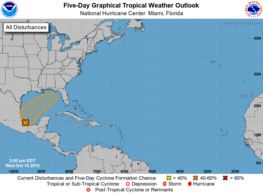
A broad area of low pressure located just offshore of the coast of
southern Mexico, in the Bay of Campeche, is producing disorganized
showers and thunderstorms. Gradual development is possible, and a
tropical or subtropical cyclone could form late this week over the
western or central Gulf of Mexico while the system is moving
generally northeastward. Regardless of development, this system
could produce gusty winds, rainfall, and rough surf along portions
of the northern Gulf Coast Friday and Saturday. An Air Force
Reserve reconnaissance aircraft is scheduled to investigate the
system Thursday afternoon, if necessary.
* Formation chance through 48 hours...medium...50 percent.
* Formation chance through 5 days...medium...50 percent.
$$
Forecaster Roberts
NWS National Hurricane Center Miami FL
200 PM EDT Wed Oct 16 2019
For the North Atlantic...Caribbean Sea and the Gulf of Mexico:
A broad area of low pressure located just offshore of the coast of
southern Mexico, in the Bay of Campeche, is producing disorganized
showers and thunderstorms. Gradual development is possible, and a
tropical or subtropical cyclone could form late this week over the
western or central Gulf of Mexico while the system is moving
generally northeastward. Regardless of development, this system
could produce gusty winds, rainfall, and rough surf along portions
of the northern Gulf Coast Friday and Saturday. An Air Force
Reserve reconnaissance aircraft is scheduled to investigate the
system Thursday afternoon, if necessary.
* Formation chance through 48 hours...medium...50 percent.
* Formation chance through 5 days...medium...50 percent.
$$
Forecaster Roberts