2022 Indicators (SSTs/SAL/MSLP/Shear/Steering/Instability) and >Day 16 Models
Moderator: S2k Moderators
Forum rules

The posts in this forum are NOT official forecasts and should not be used as such. They are just the opinion of the poster and may or may not be backed by sound meteorological data. They are NOT endorsed by any professional institution or STORM2K. For official information, please refer to products from the National Hurricane Center and National Weather Service.
-
Yellow Evan

- Professional-Met

- Posts: 16257
- Age: 27
- Joined: Fri Jul 15, 2011 12:48 pm
- Location: Henderson, Nevada/Honolulu, HI
- Contact:
Re: 2022 indicators: SSTs / SAL / MSLP / shear / steering / instability / images
Door for El Nino or probably even warm neutral is completely shut. You can thank MJO sticking in the IO for 6 weeks for this. Also contrary to whatever Klotzbach’s (modified) AMO index suggests, the actual SST configuration does not resemble a -AMO and rather an EOF2 +AMO.
6 likes
-
crownweather

- S2K Supporter

- Posts: 602
- Age: 51
- Joined: Sat Aug 12, 2006 9:21 am
- Location: Sturbridge, Massachusetts
- Contact:
Re: 2022 indicators: SSTs / SAL / MSLP / shear / steering / instability / images
wxman57 wrote:I was going back and forth with Phil Klotzbach last evening. With all March data in, the AMO has turned strongly negative (-1.8C). Phil was saying something about Kelvin wave warming the Nino 3.4 area this month, and strong signs that the Pacific SSTs may be a lot warmer than the models are predicting. That may lead to warm-neutral or even El Nino by peak season. We discussed what this would do for the storm numbers and he said he is going to be significantly lowering his prediction. I won't go into details, but named storms will be below the 30-yr average of 14/7/3. Possibly less than 10 named storms. I'll be at the National Tropical Weather Conference in South Padre with him next week.
That would be great. We could all use a quiet season.
http://wxman57.com/images/MarchAMO.png
Since today is "You can't believe anything you read on the Internet day" or otherwise known as April Fools' Day, I think we may be being pranked.
13 likes
Rob Lightbown
Crown Weather Services
https://crownweather.com
Crown Weather Services
https://crownweather.com
-
Shell Mound
- Category 5

- Posts: 2432
- Age: 33
- Joined: Thu Sep 07, 2017 3:39 pm
- Location: St. Petersburg, FL → Scandinavia
Re: 2022 indicators: SSTs / SAL / MSLP / shear / steering / instability / images
Category5Kaiju wrote:wxman57 wrote:I was going back and forth with Phil Klotzbach last evening. With all March data in, the AMO has turned strongly negative (-1.8C). Phil was saying something about Kelvin wave warming the Nino 3.4 area this month, and strong signs that the Pacific SSTs may be a lot warmer than the models are predicting. That may lead to warm-neutral or even El Nino by peak season. We discussed what this would do for the storm numbers and he said he is going to be significantly lowering his prediction. I won't go into details, but named storms will be below the 30-yr average of 14/7/3. Possibly less than 10 named storms. I'll be at the National Tropical Weather Conference in South Padre with him next week.
That would be great. We could all use a quiet season.
http://wxman57.com/images/MarchAMO.png
Have to admit, that's pretty interesting. ...
His post is likely in April Fool’s jest, given that his March forecast calls for an active season. Also, several of the past Marches featured similar AMO values.
5 likes
CVW / MiamiensisWx / Shell Mound
The posts in this forum are NOT official forecasts and should not be used as such. They are just the opinion of the poster and may or may not be backed by sound meteorological data. They are NOT endorsed by any professional institution or STORM2K. For official information, please refer to products from the NHC and NWS.
-
NotSparta

- Professional-Met
- Posts: 1677
- Age: 24
- Joined: Fri Aug 18, 2017 8:24 am
- Location: Naples, FL
- Contact:
Re: 2022 indicators: SSTs / SAL / MSLP / shear / steering / instability / images
wxman57 wrote:I was going back and forth with Phil Klotzbach last evening. With all March data in, the AMO has turned strongly negative (-1.8C). Phil was saying something about Kelvin wave warming the Nino 3.4 area this month, and strong signs that the Pacific SSTs may be a lot warmer than the models are predicting. That may lead to warm-neutral or even El Nino by peak season. We discussed what this would do for the storm numbers and he said he is going to be significantly lowering his prediction. I won't go into details, but named storms will be below the 30-yr average of 14/7/3. Possibly less than 10 named storms. I'll be at the National Tropical Weather Conference in South Padre with him next week.
That would be great. We could all use a quiet season.
http://wxman57.com/images/MarchAMO.png
Had to double check the calendar for this one
1 likes
This post was probably an opinion of mine, and in no way is official. Please refer to http://www.hurricanes.gov for official tropical analysis and advisories.
My website, with lots of tropical wx graphics, including satellite and recon: http://cyclonicwx.com
My website, with lots of tropical wx graphics, including satellite and recon: http://cyclonicwx.com
-
SFLcane

- S2K Supporter
- Posts: 10281
- Age: 48
- Joined: Sat Jun 05, 2010 1:44 pm
- Location: Lake Worth Florida
Re: 2022 indicators: SSTs / SAL / MSLP / shear / steering / instability / images
Nice one wxman57... 
0 likes
-
DorkyMcDorkface

- Category 5
- Posts: 1039
- Age: 28
- Joined: Mon Sep 30, 2019 1:32 pm
- Location: Mid-Atlantic
Re: 2022 indicators: SSTs / SAL / MSLP / shear / steering / instability / images
wxman57 wrote:I was going back and forth with Phil Klotzbach last evening. With all March data in, the AMO has turned strongly negative (-1.8C). Phil was saying something about Kelvin wave warming the Nino 3.4 area this month, and strong signs that the Pacific SSTs may be a lot warmer than the models are predicting. That may lead to warm-neutral or even El Nino by peak season. We discussed what this would do for the storm numbers and he said he is going to be significantly lowering his prediction. I won't go into details, but named storms will be below the 30-yr average of 14/7/3. Possibly less than 10 named storms. I'll be at the National Tropical Weather Conference in South Padre with him next week.
That would be great. We could all use a quiet season.
http://wxman57.com/images/MarchAMO.png

Last edited by DorkyMcDorkface on Fri Apr 01, 2022 10:59 am, edited 1 time in total.
9 likes
Please note the thoughts expressed by this account are solely those of the user and are from a hobbyist perspective. For more comprehensive analysis, consult an actual professional meteorologist or meteorological agency.
Floyd 1999 | Isabel 2003 | Hanna 2008 | Irene 2011 | Sandy 2012 | Isaias 2020
-
Category5Kaiju

- Category 5
- Posts: 4345
- Joined: Thu Dec 24, 2020 12:45 pm
- Location: Seattle during the summer, Phoenix during the winter
Re: 2022 indicators: SSTs / SAL / MSLP / shear / steering / instability / images
Oohhhh…I fell for it 
1 likes
Unless explicitly stated, all information in my posts is based on my own opinions and observations. Tropical storms and hurricanes can be extremely dangerous. Refer to an accredited weather research agency or meteorologist if you need to make serious decisions regarding an approaching storm.
-
hurricane2025
- Category 1

- Posts: 254
- Joined: Thu Apr 08, 2021 10:36 am
Re: 2022 indicators: SSTs / SAL / MSLP / shear / steering / instability / images
Last edited by tolakram on Fri Apr 01, 2022 11:06 am, edited 1 time in total.
Reason: added [tweet] tags
Reason: added [tweet] tags
1 likes

-
cycloneye

- Admin

- Posts: 149690
- Age: 69
- Joined: Thu Oct 10, 2002 10:54 am
- Location: San Juan, Puerto Rico
Re: 2022 indicators: SSTs / SAL / MSLP / shear / steering / instability / images
Is not a joke. This for JAS.

1 likes
Visit the Caribbean-Central America Weather Thread where you can find at first post web cams,radars
and observations from Caribbean basin members Click Here
and observations from Caribbean basin members Click Here
-
Shell Mound
- Category 5
- Posts: 2432
- Age: 33
- Joined: Thu Sep 07, 2017 3:39 pm
- Location: St. Petersburg, FL → Scandinavia
Re: 2022 indicators: SSTs / SAL / MSLP / shear / steering / instability / images
https://twitter.com/AndyHazelton/status/1509920178414436358
https://twitter.com/WxPatel/status/1509746829382103064
https://twitter.com/WxPatel/status/1509746835388346371
2 likes
CVW / MiamiensisWx / Shell Mound
The posts in this forum are NOT official forecasts and should not be used as such. They are just the opinion of the poster and may or may not be backed by sound meteorological data. They are NOT endorsed by any professional institution or STORM2K. For official information, please refer to products from the NHC and NWS.
-
SFLcane
- S2K Supporter
- Posts: 10281
- Age: 48
- Joined: Sat Jun 05, 2010 1:44 pm
- Location: Lake Worth Florida
Re: 2022 indicators: SSTs / SAL / MSLP / shear / steering / instability / images
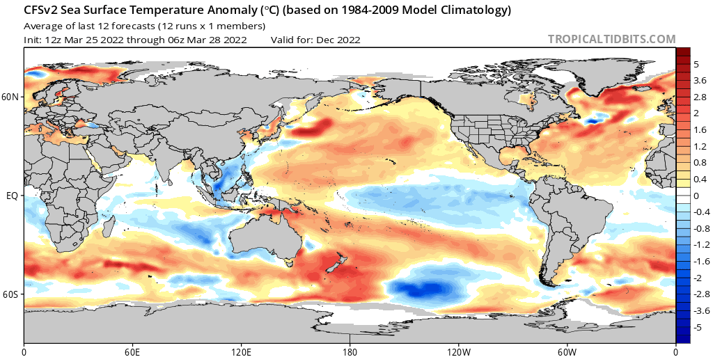
Hmmm.. That can't be correct. I see globally positve anoms all over.
0 likes
-
galaxy401

- Category 5
- Posts: 2446
- Age: 30
- Joined: Sat Aug 25, 2012 9:04 pm
- Location: Casa Grande, Arizona
Re: 2022 indicators: SSTs / SAL / MSLP / shear / steering / instability / images
wxman57 wrote:I was going back and forth with Phil Klotzbach last evening. With all March data in, the AMO has turned strongly negative (-1.8C). Phil was saying something about Kelvin wave warming the Nino 3.4 area this month, and strong signs that the Pacific SSTs may be a lot warmer than the models are predicting. That may lead to warm-neutral or even El Nino by peak season. We discussed what this would do for the storm numbers and he said he is going to be significantly lowering his prediction. I won't go into details, but named storms will be below the 30-yr average of 14/7/3. Possibly less than 10 named storms. I'll be at the National Tropical Weather Conference in South Padre with him next week.
That would be great. We could all use a quiet season.
http://wxman57.com/images/MarchAMO.png
That post looked very legit honestly until the last couple sentences.
1 likes
Got my eyes on moving right into Hurricane Alley: Florida.
Re: 2022 indicators: SSTs / SAL / MSLP / shear / steering / instability / images


Favors warming in the East MDR.
0 likes
-
Shell Mound
- Category 5
- Posts: 2432
- Age: 33
- Joined: Thu Sep 07, 2017 3:39 pm
- Location: St. Petersburg, FL → Scandinavia
Re: 2022 indicators: SSTs / SAL / MSLP / shear / steering / instability / images
crownweather wrote:wxman57 wrote:I was going back and forth with Phil Klotzbach last evening. With all March data in, the AMO has turned strongly negative (-1.8C). Phil was saying something about Kelvin wave warming the Nino 3.4 area this month, and strong signs that the Pacific SSTs may be a lot warmer than the models are predicting. That may lead to warm-neutral or even El Nino by peak season. We discussed what this would do for the storm numbers and he said he is going to be significantly lowering his prediction. I won't go into details, but named storms will be below the 30-yr average of 14/7/3. Possibly less than 10 named storms. I'll be at the National Tropical Weather Conference in South Padre with him next week.
That would be great. We could all use a quiet season.
http://wxman57.com/images/MarchAMO.png
Since today is "You can't believe anything you read on the Internet day" or otherwise known as April Fools' Day, I think we may be being pranked.
https://twitter.com/philklotzbach/status/1504895691327344641
https://twitter.com/Petagna/status/1504175462163140610
https://twitter.com/jnmet/status/1508908216138219528
Note that a -IOD would tend to align with cool neutral ENSO or La Niña during meteorological fall and/or winter of 2022.
0 likes
CVW / MiamiensisWx / Shell Mound
The posts in this forum are NOT official forecasts and should not be used as such. They are just the opinion of the poster and may or may not be backed by sound meteorological data. They are NOT endorsed by any professional institution or STORM2K. For official information, please refer to products from the NHC and NWS.
-
AlphaToOmega
- Category 5
- Posts: 1448
- Joined: Sat Jun 26, 2021 10:51 am
- Location: Somewhere in Massachusetts
Re: 2022 indicators: SSTs / SAL / MSLP / shear / steering / instability / images
I am still waiting for the next monthly ECMWF. The ECMWF has the ENSO as mostly a tossup for this hurricane season, which is not in line with other models. The CFSv2 says there is a 100% chance of -ENSO for ASO, and the JMA says there is >80% chance of -ENSO for ASO. I still have 2006 and 2012 as potential analogs because I still think there is a chance—not a very likely chance—but a chance—that 2022 could feature a +ENSO for ASO. I think we will know in the next couple of days if the door to a +ENSO (thus the door to a below-average season) is shut.
0 likes
-
Category5Kaiju
- Category 5
- Posts: 4345
- Joined: Thu Dec 24, 2020 12:45 pm
- Location: Seattle during the summer, Phoenix during the winter
Re: 2022 indicators: SSTs / SAL / MSLP / shear / steering / instability / images
While I am not personally sure if it means anything, the Australian and South Pacific basins have seemingly been extremely quiet this season (if I am not mistaken, Vernon was the only major strength storm to occur in either basin so far, albeit a Cat 3). Maybe this La Nina or something about the ENSO state is causing this to occur? Like I said, I have no idea if this means anything for the Atlantic, but it is indeed an interesting observation.
0 likes
Unless explicitly stated, all information in my posts is based on my own opinions and observations. Tropical storms and hurricanes can be extremely dangerous. Refer to an accredited weather research agency or meteorologist if you need to make serious decisions regarding an approaching storm.
-
AlphaToOmega
- Category 5
- Posts: 1448
- Joined: Sat Jun 26, 2021 10:51 am
- Location: Somewhere in Massachusetts
Re: 2022 indicators: SSTs / SAL / MSLP / shear / steering / instability / images
There is a chance 2022-2023 might be a +ENSO winter. A triple dip La Nina is not a sure thing.
0 likes
-
Category5Kaiju
- Category 5
- Posts: 4345
- Joined: Thu Dec 24, 2020 12:45 pm
- Location: Seattle during the summer, Phoenix during the winter
Re: 2022 indicators: SSTs / SAL / MSLP / shear / steering / instability / images
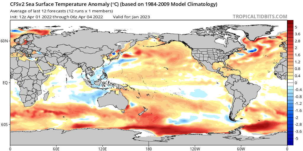
AlphaToOmega wrote:There is a chance 2022-2023 might be a +ENSO winter. A triple dip La Nina is not a sure thing.
https://i.postimg.cc/XYCbh1Rs/cfs-mon-01-ssta-global-9.png
Except if I recall correctly, that used to be glaringly +ENSO earlier this year (meaning the trend has been cooler over the past months or so)
0 likes
Unless explicitly stated, all information in my posts is based on my own opinions and observations. Tropical storms and hurricanes can be extremely dangerous. Refer to an accredited weather research agency or meteorologist if you need to make serious decisions regarding an approaching storm.
-
AlphaToOmega
- Category 5
- Posts: 1448
- Joined: Sat Jun 26, 2021 10:51 am
- Location: Somewhere in Massachusetts
Re: 2022 indicators: SSTs / SAL / MSLP / shear / steering / instability / images
Category5Kaiju wrote:AlphaToOmega wrote:There is a chance 2022-2023 might be a +ENSO winter. A triple dip La Nina is not a sure thing.
https://i.postimg.cc/XYCbh1Rs/cfs-mon-01-ssta-global-9.png
Except if I recall correctly, that used to be glaringly +ENSO earlier this year (meaning the trend has been cooler over the past months or so)
There seems to be a trend towards a warmer ENSO for this winter:
I wonder what could be causing this.
0 likes
Who is online
Users browsing this forum: No registered users and 162 guests