2023 Indicators (SST, SAL, MSLP, Wind shear, Steering, Instability) and Day 16+ Models
Moderator: S2k Moderators
Forum rules

The posts in this forum are NOT official forecasts and should not be used as such. They are just the opinion of the poster and may or may not be backed by sound meteorological data. They are NOT endorsed by any professional institution or STORM2K. For official information, please refer to products from the National Hurricane Center and National Weather Service.
-
SFLcane

- S2K Supporter

- Posts: 10281
- Age: 48
- Joined: Sat Jun 05, 2010 1:44 pm
- Location: Lake Worth Florida
Re: 2023 Indicators (SST, SAL, MSLP, Wind shear, Steering, Instability) and Day 16+ Models
Anyone tells you they know what’s happening this season is straight up lying in my opinion. We shall see
3 likes
-
Category5Kaiju

- Category 5

- Posts: 4322
- Joined: Thu Dec 24, 2020 12:45 pm
- Location: Seattle and Phoenix
Re: 2023 Indicators (SST, SAL, MSLP, Wind shear, Steering, Instability) and Day 16+ Models
SFLcane wrote:Anyone tells you they know what’s happening this season is straight up lying in my opinion. We shall see
This is the first Atlantic season I've tracked since 2017 where I genuinely have very little clue as to how it will pan out due to how many conflicting signals there are. 2018 and 2019 I felt pretty bearish (was kind of wrong about both), 2020 was very bullish, 2021 was pretty bullish, and 2022 was pretty bullish (although I kind of got that one wrong too
But one thing I do have some decent confidence in: I wouldn't be surprised if this season manages to do very strange things and defy expectations in certain parameters.
9 likes
Unless explicitly stated, all info in my posts is based on my own opinions and observations. Tropical storms and hurricanes can be extremely dangerous. Refer to an accredited weather research agency or meteorologist if you need to make serious decisions regarding an approaching storm.
-
cycloneye

- Admin

- Posts: 149123
- Age: 69
- Joined: Thu Oct 10, 2002 10:54 am
- Location: San Juan, Puerto Rico
Re: 2023 Indicators (SST, SAL, MSLP, Wind shear, Steering, Instability) and Day 16+ Models
Interesting the number of storms for years that had both El NIño ansd warm MDR ssts.
https://twitter.com/catinsight/status/1645406904158388224
https://twitter.com/catinsight/status/1645406904158388224
2 likes
Visit the Caribbean-Central America Weather Thread where you can find at first post web cams,radars
and observations from Caribbean basin members Click Here
and observations from Caribbean basin members Click Here
-
Iceresistance

- Category 5
- Posts: 9565
- Age: 22
- Joined: Sat Oct 10, 2020 9:45 am
- Location: Tecumseh, OK/Norman, OK
Re: 2023 Indicators (SST, SAL, MSLP, Wind shear, Steering, Instability) and Day 16+ Models
0 likes
Bill 2015 & Beta 2020
Winter 2020-2021
All observations are in Tecumseh, OK unless otherwise noted.
Winter posts are focused mainly for Oklahoma & Texas.
Take any of my forecasts with a grain of salt, refer to the NWS, SPC, and NHC for official information
Never say Never with weather! Because ANYTHING is possible!
Winter 2020-2021
All observations are in Tecumseh, OK unless otherwise noted.
Winter posts are focused mainly for Oklahoma & Texas.
Take any of my forecasts with a grain of salt, refer to the NWS, SPC, and NHC for official information
Never say Never with weather! Because ANYTHING is possible!
-
cycloneye
- Admin
- Posts: 149123
- Age: 69
- Joined: Thu Oct 10, 2002 10:54 am
- Location: San Juan, Puerto Rico
Re: 2023 Indicators (SST, SAL, MSLP, Wind shear, Steering, Instability) and Day 16+ Models
1 likes
Visit the Caribbean-Central America Weather Thread where you can find at first post web cams,radars
and observations from Caribbean basin members Click Here
and observations from Caribbean basin members Click Here
-
SFLcane
- S2K Supporter
- Posts: 10281
- Age: 48
- Joined: Sat Jun 05, 2010 1:44 pm
- Location: Lake Worth Florida
Re: 2023 Indicators (SST, SAL, MSLP, Wind shear, Steering, Instability) and Day 16+ Models
However..................

0 likes
-
Kingarabian

- S2K Supporter
- Posts: 16338
- Joined: Sat Aug 08, 2009 3:06 am
- Location: Honolulu, Hawaii
Re: 2023 Indicators (SST, SAL, MSLP, Wind shear, Steering, Instability) and Day 16+ Models
The opposite is also true. Hard to guess what's going to happen.
4 likes
RIP Kobe Bryant
-
AlanSnyder35
- Tropical Low

- Posts: 21
- Joined: Sat Apr 22, 2023 2:41 pm
Re: 2023 Indicators (SST, SAL, MSLP, Wind shear, Steering, Instability) and Day 16+ Models
When you still use the word however this deep you know things are still up in the air
0 likes
-
DorkyMcDorkface

- Category 4

- Posts: 976
- Age: 28
- Joined: Mon Sep 30, 2019 1:32 pm
- Location: Mid-Atlantic
Re: 2023 Indicators (SST, SAL, MSLP, Wind shear, Steering, Instability) and Day 16+ Models
Still think the Niño will ultimately win out in the end but there is a decent chance that the basin could still put up respectable numbers (or at least more respectable than what we typically see during these events). I've said this before but the eastern and central MDR have the potential to be relatively hospitable if TWs can get going early on (especially if aided by well-timed CCKW/MJO passage). 55W and beyond should be where storms will start encountering problems with shear the further W they track, and the Caribbean should be off-limits as is typical with El Niños, but I guess that goes without saying.
4 likes
Please note the thougths expressed by this account are solely those of the user and are from a hobbyist perspective. For more comprehensive analysis, consult an actual professional meteorologist or meteorology agency.
Floyd 1999 | Isabel 2003 | Hanna 2008 | Irene 2011 | Sandy 2012 | Isaias 2020


Re: 2023 Indicators (SST, SAL, MSLP, Wind shear, Steering, Instability) and Day 16+ Models
DorkyMcDorkface wrote:
Still think the Niño will ultimately win out in the end but there is a decent chance that the basin could still put up respectable numbers (or at least more respectable than what we typically see during these events). I've said this before but the eastern and central MDR have the potential to be relatively hospitable if TWs can get going early on (especially if aided by well-timed CCKW/MJO passage). 55W and beyond should be where storms will start encountering problems with shear the further W they track, and the Caribbean should be off-limits as is typical with El Niños, but I guess that goes without saying.
I agree. Prior recent active seasons we saw most waves struggle across the open Atlantic, with some rapidly intensifying under extremely favorable conditions near land. This season I suspect we will be tracking developed, consolidated systems crossing the MDR and putting up respectable ACE. Most will likely get sheared to death in the Carrib and WATL, but some may travel North enough or find favorable enough pockets of atmospheric conditions to become threats to land. I'd say the EC will be more at risk this season compared to the Gulf-focused landfalls we've had recently.
4 likes
-
weeniepatrol

- Category 5
- Posts: 1339
- Joined: Sat Aug 22, 2020 5:30 pm
- Location: WA State
Re: 2023 Indicators (SST, SAL, MSLP, Wind shear, Steering, Instability) and Day 16+ Models
DorkyMcDorkface wrote:
Still think the Niño will ultimately win out in the end but there is a decent chance that the basin could still put up respectable numbers (or at least more respectable than what we typically see during these events). I've said this before but the eastern and central MDR have the potential to be relatively hospitable if TWs can get going early on (especially if aided by well-timed CCKW/MJO passage). 55W and beyond should be where storms will start encountering problems with shear the further W they track, and the Caribbean should be off-limits as is typical with El Niños, but I guess that goes without saying.
Agree completely, if this nino were going super we could probably expect a standing wave over the Epac that just nukes the Atlantic but with a lesser amplitude and this prolific Atlantic warmth, intraseasonal forcing should be able to make its way through providing windows of development. 3-4 majors is definitely possible. NOAA forecast should be soon.
2 likes
-
cycloneye
- Admin
- Posts: 149123
- Age: 69
- Joined: Thu Oct 10, 2002 10:54 am
- Location: San Juan, Puerto Rico
Re: 2023 Indicators (SST, SAL, MSLP, Wind shear, Steering, Instability) and Day 16+ Models
Webbs analogs.1877, 1896, 1899, 1965, 1969.
https://twitter.com/webberweather/status/1653151706082074624
https://twitter.com/webberweather/status/1653151706082074624
2 likes
Visit the Caribbean-Central America Weather Thread where you can find at first post web cams,radars
and observations from Caribbean basin members Click Here
and observations from Caribbean basin members Click Here
-
Category5Kaiju
- Category 5
- Posts: 4322
- Joined: Thu Dec 24, 2020 12:45 pm
- Location: Seattle and Phoenix
Re: 2023 Indicators (SST, SAL, MSLP, Wind shear, Steering, Instability) and Day 16+ Models
cycloneye wrote:Webbs analogs.1877, 1896, 1899, 1965, 1969.
https://twitter.com/webberweather/status/1653151706082074624
San Ciriaco Hurricane, Betsy, and Camille ring any bells???
Yeah, those analog years confirm my suspicion that the Bahamas, Eastern Florida, and the SE US Seaboard may really need to keep an eye out
3 likes
Unless explicitly stated, all info in my posts is based on my own opinions and observations. Tropical storms and hurricanes can be extremely dangerous. Refer to an accredited weather research agency or meteorologist if you need to make serious decisions regarding an approaching storm.
-
cycloneye
- Admin
- Posts: 149123
- Age: 69
- Joined: Thu Oct 10, 2002 10:54 am
- Location: San Juan, Puerto Rico
Re: 2023 Indicators (SST, SAL, MSLP, Wind shear, Steering, Instability) and Day 16+ Models
Category5Kaiju wrote:cycloneye wrote:Webbs analogs.1877, 1896, 1899, 1965, 1969.
https://twitter.com/webberweather/status/1653151706082074624
San Ciriaco Hurricane, Betsy, and Camille ring any bells???
Yeah, those analog years confirm my suspicion that the Bahamas, Eastern Florida, and the SE US Seaboard may really need to keep an eye out
Exactly.
https://twitter.com/webberweather/status/1653157467604541441
0 likes
Visit the Caribbean-Central America Weather Thread where you can find at first post web cams,radars
and observations from Caribbean basin members Click Here
and observations from Caribbean basin members Click Here
-
AnnularCane

- S2K Supporter
- Posts: 2951
- Joined: Thu Jun 08, 2006 9:18 am
- Location: Wytheville, VA
Re: 2023 Indicators (SST, SAL, MSLP, Wind shear, Steering, Instability) and Day 16+ Models
All of a sudden I have this funny feeling that at the end of the season everybody will be saying "if the season was like this with an El Nino, just imagine how bad it would have been WITHOUT it!"
10 likes
"But it never rained rain. It never snowed snow. And it never blew just wind. It rained things like soup and juice. It snowed mashed potatoes and green peas. And sometimes the wind blew in storms of hamburgers." -- Judi Barrett, Cloudy with a Chance of Meatballs
-
Category5Kaiju
- Category 5
- Posts: 4322
- Joined: Thu Dec 24, 2020 12:45 pm
- Location: Seattle and Phoenix
Re: 2023 Indicators (SST, SAL, MSLP, Wind shear, Steering, Instability) and Day 16+ Models
AnnularCane wrote:All of a sudden I have this funny feeling that at the end of the season everybody will be saying "if the season was like this with an El Nino, just imagine how bad it would have been WITHOUT it!"
It's inevitable. You know very well. It cannot be stopped
2 likes
Unless explicitly stated, all info in my posts is based on my own opinions and observations. Tropical storms and hurricanes can be extremely dangerous. Refer to an accredited weather research agency or meteorologist if you need to make serious decisions regarding an approaching storm.
-
SFLcane
- S2K Supporter
- Posts: 10281
- Age: 48
- Joined: Sat Jun 05, 2010 1:44 pm
- Location: Lake Worth Florida
Re: 2023 Indicators (SST, SAL, MSLP, Wind shear, Steering, Instability) and Day 16+ Models
Those analogs spell trouble for Florida potentially with the SW Atlantic being a hotspot.
1 likes
Re: 2023 Indicators (SST, SAL, MSLP, Wind shear, Steering, Instability) and Day 16+ Models

EPS trending weaker on the El Nino standing wave, stronger on the Africa standing wave. With MJO moving into phase 8/1 later this month, we might see the first storm of the season soon.
1 likes
-
Blown Away

- S2K Supporter
- Posts: 10253
- Joined: Wed May 26, 2004 6:17 am
Re: 2023 Indicators (SST, SAL, MSLP, Wind shear, Steering, Instability) and Day 16+ Models
cycloneye wrote:Webbs analogs.1877, 1896, 1899, 1965, 1969.
https://twitter.com/webberweather/status/1653151706082074624
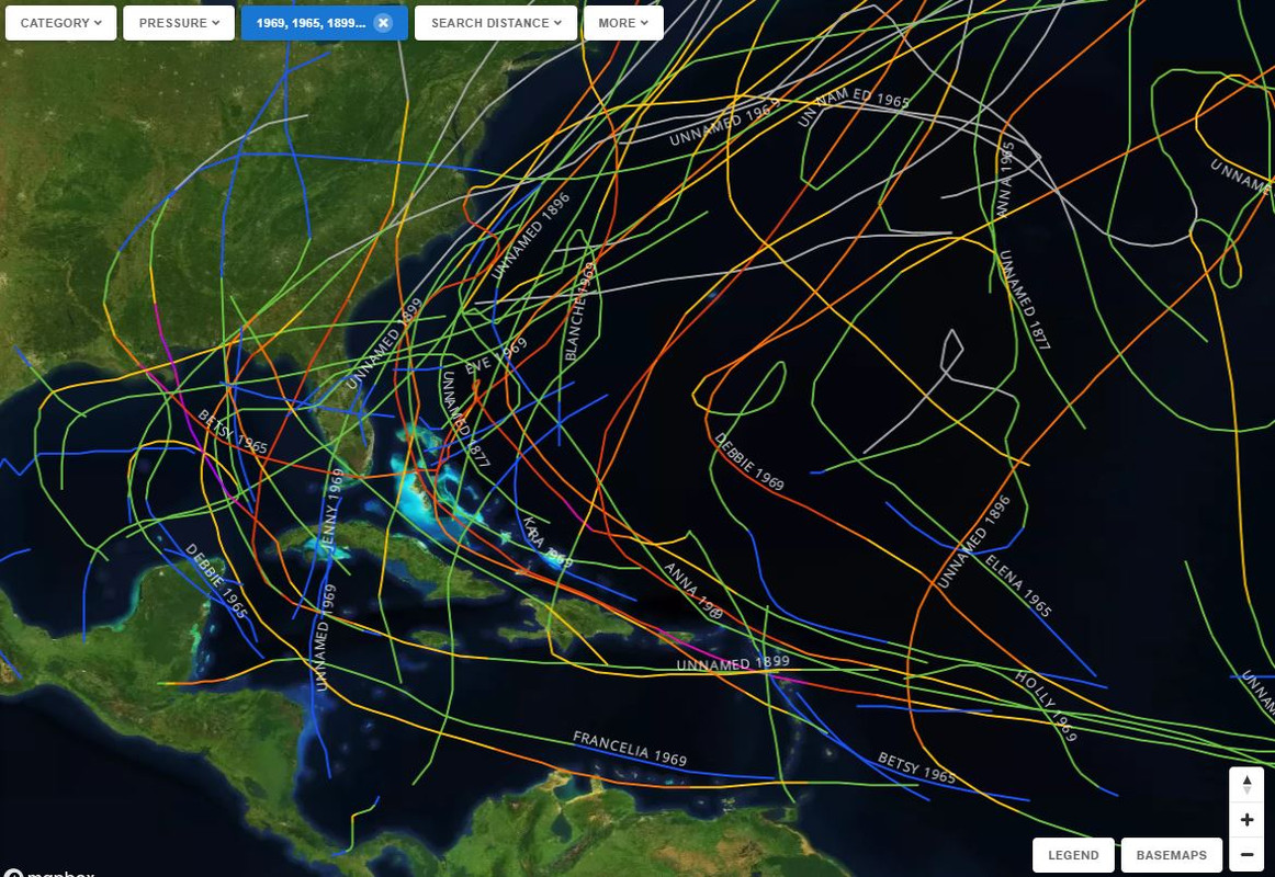
5 analog years. Busy W Atlantic basin...
1 likes
Hurricane Eye Experience: David 79, Irene 99, Frances 04, Jeanne 04, Wilma 05… Hurricane Brush Experience: Andrew 92, Erin 95, Floyd 99, Matthew 16, Irma 17, Ian 22, Nicole 22…
Who is online
Users browsing this forum: No registered users and 105 guests