2023 Global Model Runs Discussion (Out thru day 16)
Moderator: S2k Moderators
Forum rules

The posts in this forum are NOT official forecasts and should not be used as such. They are just the opinion of the poster and may or may not be backed by sound meteorological data. They are NOT endorsed by any professional institution or STORM2K. For official information, please refer to products from the National Hurricane Center and National Weather Service.
Re: 2023 Global Model Runs Discussion (Out thru day 16)
WeatherBoy2000 wrote:SFLcane wrote:
Fun is just starting. If these conditions come to pass with a TUTT placement similar to 2004 with the right steering look out.
https://i.postimg.cc/htk95jkh/cfs33.png
If development were to occur in the mdr this month, it could be a sign pointing towards a more active season down the line. Early mdr development in June through early July is unusual and correlates quite well with active seasons. Development of this wave could help further back up the case that we're looking at a more active season than usually expected with a robust El Nino.
With the 12Z Euro showing a TD in the MDR as early as on 6/21, that chance is increasing. That could very well be as you suggest an early indicator of an active season, especially compared to other robust Niño events.
However, to consider another possibility based on just last year, late June had two very impressive AEWs that had significant impact in the Caribbean. The 2nd one moved off Africa on June 23rd and lead to PTC advisories starting on 6/27 as it got to 51W. This later became Bonnie. Similar discussions were suggesting a very active MDR.
But after Bonnie, there wasn't even one impressive AEW for nearly two months until the one that formed into Earl moved off Africa on August 25th and became Earl near the LAs on 9/2-3. Everything that came off Africa was dry as a bone for two months and many folks were very surprised.
5 likes
Personal Forecast Disclaimer:
The posts in this forum are NOT official forecasts and should not be used as such. They are just the opinion of the poster and may or may not be backed by sound meteorological data. They are NOT endorsed by any professional institution or storm2k.org. For official information, please refer to the NHC and NWS products.
The posts in this forum are NOT official forecasts and should not be used as such. They are just the opinion of the poster and may or may not be backed by sound meteorological data. They are NOT endorsed by any professional institution or storm2k.org. For official information, please refer to the NHC and NWS products.
-
SFLcane

- S2K Supporter

- Posts: 10281
- Age: 48
- Joined: Sat Jun 05, 2010 1:44 pm
- Location: Lake Worth Florida
Re: 2023 Global Model Runs Discussion (Out thru day 16)
LarryWx wrote:WeatherBoy2000 wrote:SFLcane wrote:
Fun is just starting. If these conditions come to pass with a TUTT placement similar to 2004 with the right steering look out.
https://i.postimg.cc/htk95jkh/cfs33.png
If development were to occur in the mdr this month, it could be a sign pointing towards a more active season down the line. Early mdr development in June through early July is unusual and correlates quite well with active seasons. Development of this wave could help further back up the case that we're looking at a more active season than usually expected with a robust El Nino.
With the 12Z Euro showing a TD in the MDR as early as on 6/21, that chance is increasing. That could very well be as you suggest an early indicator of an active season, especially compared to other robust Niño events.
However, to consider another possibility based on just last year, June had two very impressive AEWs that had significant impact in the Caribbean. The 2nd one moved off Africa on June 23rd and lead to PTC advisories starting on 6/27 as it got to 51W. This later became Bonnie. Similar discussions were suggesting a very active MDR.
But after Bonnie, there wasn't even one impressive AEW for nearly two months until the one that formed into Earl moved off Africa on August 25th and became Earl near the LAs on 9/2-3. Everything that came off Africa was dry as a bone for two months and many folks were very surprised.
I would venture at 216 that is a weak TS near the islands on the euro. Impressive for june
1 likes
Re: 2023 Global Model Runs Discussion (Out thru day 16)
SFLcane wrote:LarryWx wrote:WeatherBoy2000 wrote:
If development were to occur in the mdr this month, it could be a sign pointing towards a more active season down the line. Early mdr development in June through early July is unusual and correlates quite well with active seasons. Development of this wave could help further back up the case that we're looking at a more active season than usually expected with a robust El Nino.
With the 12Z Euro showing a TD in the MDR as early as on 6/21, that chance is increasing. That could very well be as you suggest an early indicator of an active season, especially compared to other robust Niño events.
However, to consider another possibility based on just last year, June had two very impressive AEWs that had significant impact in the Caribbean. The 2nd one moved off Africa on June 23rd and lead to PTC advisories starting on 6/27 as it got to 51W. This later became Bonnie. Similar discussions were suggesting a very active MDR.
But after Bonnie, there wasn't even one impressive AEW for nearly two months until the one that formed into Earl moved off Africa on August 25th and became Earl near the LAs on 9/2-3. Everything that came off Africa was dry as a bone for two months and many folks were very surprised.
I would venture at 216 that is a weak TS near the islands on the euro. Impressive for june
Absolutely would be impressive for June to have an MDR TC.
I'm surprised Luis hasn't posted in several days. I hope he's ok.
0 likes
Personal Forecast Disclaimer:
The posts in this forum are NOT official forecasts and should not be used as such. They are just the opinion of the poster and may or may not be backed by sound meteorological data. They are NOT endorsed by any professional institution or storm2k.org. For official information, please refer to the NHC and NWS products.
The posts in this forum are NOT official forecasts and should not be used as such. They are just the opinion of the poster and may or may not be backed by sound meteorological data. They are NOT endorsed by any professional institution or storm2k.org. For official information, please refer to the NHC and NWS products.
-
Hurricane2022

- Category 5

- Posts: 2092
- Joined: Tue Aug 23, 2022 11:38 pm
- Location: Araçatuba, Brazil
Re: 2023 Global Model Runs Discussion (Out thru day 16)
LarryWx wrote:SFLcane wrote:LarryWx wrote:
With the 12Z Euro showing a TD in the MDR as early as on 6/21, that chance is increasing. That could very well be as you suggest an early indicator of an active season, especially compared to other robust Niño events.
However, to consider another possibility based on just last year, June had two very impressive AEWs that had significant impact in the Caribbean. The 2nd one moved off Africa on June 23rd and lead to PTC advisories starting on 6/27 as it got to 51W. This later became Bonnie. Similar discussions were suggesting a very active MDR.
But after Bonnie, there wasn't even one impressive AEW for nearly two months until the one that formed into Earl moved off Africa on August 25th and became Earl near the LAs on 9/2-3. Everything that came off Africa was dry as a bone for two months and many folks were very surprised.
I would venture at 216 that is a weak TS near the islands on the euro. Impressive for june
Absolutely would be impressive for June to have an MDR TC.
I'm surprised Luis hasn't posted in several days. I hope he's ok.
https://www.storm2k.org/phpbb2/viewtopi ... 7&t=123409
He is ok but is struggling to get his account back
3 likes
Sorry for the bad English sometimes...!
For reliable and detailed information for any meteorological phenomenon, please consult the National Hurricane Center, Joint Typhoon Warning Center , or your local Meteo Center.
--------
ECCE OMNIA NOVA FACIAM (Ap 21,5).
For reliable and detailed information for any meteorological phenomenon, please consult the National Hurricane Center, Joint Typhoon Warning Center , or your local Meteo Center.
--------
ECCE OMNIA NOVA FACIAM (Ap 21,5).
-
WeatherBoy2000
- Category 1

- Posts: 463
- Joined: Mon Apr 10, 2023 9:29 am
Re: 2023 Global Model Runs Discussion (Out thru day 16)
LarryWx wrote:WeatherBoy2000 wrote:SFLcane wrote:
Fun is just starting. If these conditions come to pass with a TUTT placement similar to 2004 with the right steering look out.
https://i.postimg.cc/htk95jkh/cfs33.png
If development were to occur in the mdr this month, it could be a sign pointing towards a more active season down the line. Early mdr development in June through early July is unusual and correlates quite well with active seasons. Development of this wave could help further back up the case that we're looking at a more active season than usually expected with a robust El Nino.
With the 12Z Euro showing a TD in the MDR as early as on 6/21, that chance is increasing. That could very well be as you suggest an early indicator of an active season, especially compared to other robust Niño events.
However, to consider another possibility based on just last year, late June had two very impressive AEWs that had significant impact in the Caribbean. The 2nd one moved off Africa on June 23rd and lead to PTC advisories starting on 6/27 as it got to 51W. This later became Bonnie. Similar discussions were suggesting a very active MDR.
But after Bonnie, there wasn't even one impressive AEW for nearly two months until the one that formed into Earl moved off Africa on August 25th and became Earl near the LAs on 9/2-3. Everything that came off Africa was dry as a bone for two months and many folks were very surprised.
Yeah it's not a perfect correlation by any means and the notorious 2013 hurricane season also had this happen. In general, early season mdr development like this typically leads to a more active season and is even rarer with +enso years. 2018 is the most recent +enso year with early July mdr development and that year largely outperformed expectations from what I can recall. I just see this as another indication that the Atlantic may perform better than usual in the face of a likely robust el nino event (assuming that TC formation happens at all).
5 likes
-
USTropics
- Professional-Met

- Posts: 2740
- Joined: Sun Aug 12, 2007 3:45 am
- Location: Florida State University
Re: 2023 Global Model Runs Discussion (Out thru day 16)
WeatherBoy2000 wrote:LarryWx wrote:WeatherBoy2000 wrote:
If development were to occur in the mdr this month, it could be a sign pointing towards a more active season down the line. Early mdr development in June through early July is unusual and correlates quite well with active seasons. Development of this wave could help further back up the case that we're looking at a more active season than usually expected with a robust El Nino.
With the 12Z Euro showing a TD in the MDR as early as on 6/21, that chance is increasing. That could very well be as you suggest an early indicator of an active season, especially compared to other robust Niño events.
However, to consider another possibility based on just last year, late June had two very impressive AEWs that had significant impact in the Caribbean. The 2nd one moved off Africa on June 23rd and lead to PTC advisories starting on 6/27 as it got to 51W. This later became Bonnie. Similar discussions were suggesting a very active MDR.
But after Bonnie, there wasn't even one impressive AEW for nearly two months until the one that formed into Earl moved off Africa on August 25th and became Earl near the LAs on 9/2-3. Everything that came off Africa was dry as a bone for two months and many folks were very surprised.
Yeah it's not a perfect correlation by any means and the notorious 2013 hurricane season also had this happen. In general, early season mdr development like this typically leads to a more active season and is even rarer with +enso years. 2018 is the most recent +enso year with early July mdr development and that year largely outperformed expectations from what I can recall. I just see this as another indication that the Atlantic may perform better than usual in the face of a likely robust el nino event (assuming that TC formation happens at all).
Here is the research for all systems that formed east of the Caribbean and below 20N in the months of June/July:
Code: Select all
Bonnie 2022 (06/27)
Elsa 2021 (06/30)
Isaias 2020 (07/28)
Gonzalo 2020 (07/20)
Beryl 2018 (07/04)
Don 2017 (07/17)
Bret 2017 (06/18)
Bertha 2014 (07/29)
Dorian 2013 (07/22)
Chantal 2013 (07/07)
Bertha 2008 (07/03)
Emily 2005 (07/11)
Claudette 2003 (07/07)
Alex 1998 (07/27)
Bertha 1996 (07/05)
Chantal 1995 (07/12)
Arthur 1990 (07/22)
Barry 1989 (07/09)
Allen 1980 (07/31)
Claudette 1979 (07/15)
Ana 1979 (06/19)
Anna 1969 (07/25)
Ella 1966 (07/22)
Arlene 1963 (07/31)
Ace for those years:
Code: Select all
YEAR   ACE
2022   95.1
2021   145.7
2020   179.8
2018   132.6
2017   224.9
2013   36.1
2008   145.7
2005   245.3
1998   181.8
1996   166.2
1995   227.1
1990   96.8
1979   92.9
1969   165.7
1966   145.2
1963   112.1
Average ACE is 149.56. If you removed the unicorn year of 2013, average ACE would be 157.13.
5 likes

Re: 2023 Global Model Runs Discussion (Out thru day 16)
USTropics wrote:WeatherBoy2000 wrote:LarryWx wrote:
With the 12Z Euro showing a TD in the MDR as early as on 6/21, that chance is increasing. That could very well be as you suggest an early indicator of an active season, especially compared to other robust Niño events.
However, to consider another possibility based on just last year, late June had two very impressive AEWs that had significant impact in the Caribbean. The 2nd one moved off Africa on June 23rd and lead to PTC advisories starting on 6/27 as it got to 51W. This later became Bonnie. Similar discussions were suggesting a very active MDR.
But after Bonnie, there wasn't even one impressive AEW for nearly two months until the one that formed into Earl moved off Africa on August 25th and became Earl near the LAs on 9/2-3. Everything that came off Africa was dry as a bone for two months and many folks were very surprised.
Yeah it's not a perfect correlation by any means and the notorious 2013 hurricane season also had this happen. In general, early season mdr development like this typically leads to a more active season and is even rarer with +enso years. 2018 is the most recent +enso year with early July mdr development and that year largely outperformed expectations from what I can recall. I just see this as another indication that the Atlantic may perform better than usual in the face of a likely robust el nino event (assuming that TC formation happens at all).
Here is the research for all systems that formed east of the Caribbean and below 20N in the months of June/July:Code: Select all
Bonnie 2022 (06/27)
Elsa 2021 (06/30)
Isaias 2020 (07/28)
Gonzalo 2020 (07/20)
Beryl 2018 (07/04)
Don 2017 (07/17)
Bret 2017 (06/18)
Bertha 2014 (07/29)
Dorian 2013 (07/22)
Chantal 2013 (07/07)
Bertha 2008 (07/03)
Emily 2005 (07/11)
Claudette 2003 (07/07)
Alex 1998 (07/27)
Bertha 1996 (07/05)
Chantal 1995 (07/12)
Arthur 1990 (07/22)
Barry 1989 (07/09)
Allen 1980 (07/31)
Claudette 1979 (07/15)
Ana 1979 (06/19)
Anna 1969 (07/25)
Ella 1966 (07/22)
Arlene 1963 (07/31)
Ace for those years:Code: Select all
YEAR   ACE
2022   95.1
2021   145.7
2020   179.8
2018   132.6
2017   224.9
2013   36.1
2008   145.7
2005   245.3
1998   181.8
1996   166.2
1995   227.1
1990   96.8
1979   92.9
1969   165.7
1966   145.2
1963   112.1
Average ACE is 149.56. If you removed the unicorn year of 2013, average ACE would be 157.13.
I believe this is bugged, as Bonnie and Isaias didn't form until they entered the Caribbean, and Bertha 2014 only became a TC on Aug 1. Did you count their time as a waves and PTC?
2 likes
TC naming lists: retirements and intensity
Most aggressive Advisory #1's in North Atlantic (cr. kevin for starting the list)
Most aggressive Advisory #1's in North Atlantic (cr. kevin for starting the list)

Re: 2023 Global Model Runs Discussion (Out thru day 16)
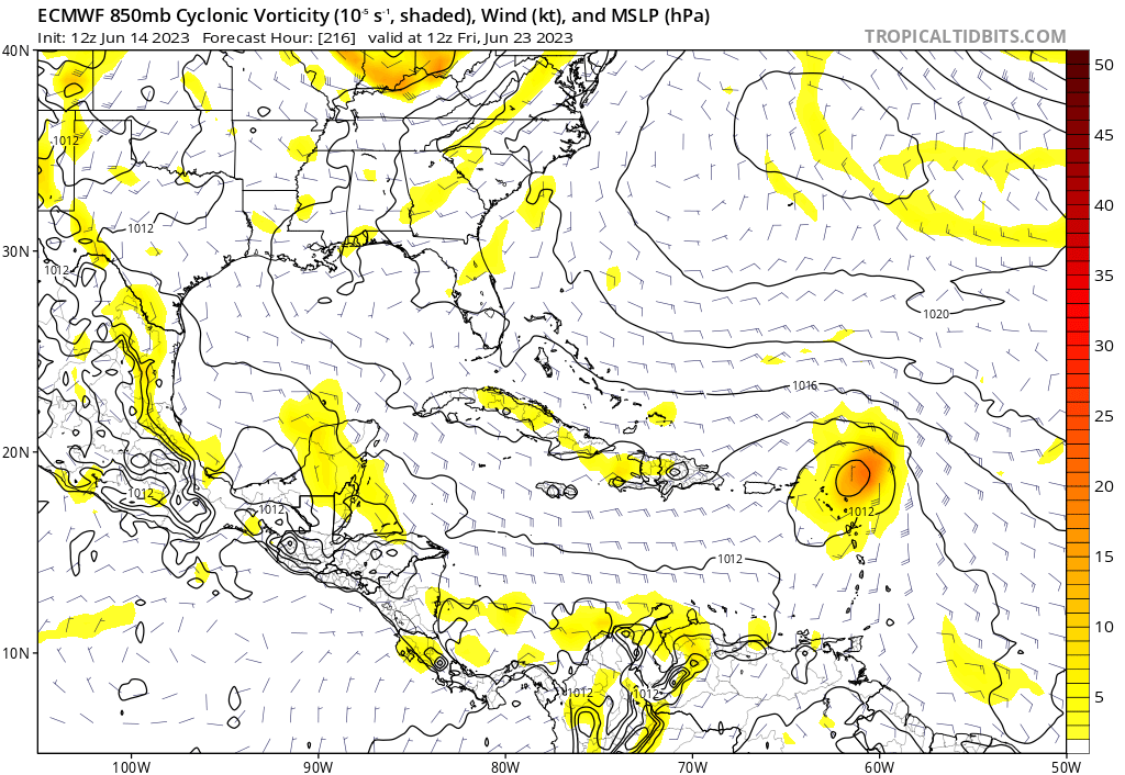
GFS is now showing MDR development within 90 hours. While I doubt a system will form that far east, it looks increasingly likely that we will get an MDR cyclone. Thankfully, shear seems to shred it before it approaches land.
1 likes
-
USTropics
- Professional-Met
- Posts: 2740
- Joined: Sun Aug 12, 2007 3:45 am
- Location: Florida State University
Re: 2023 Global Model Runs Discussion (Out thru day 16)
Teban54 wrote:USTropics wrote:WeatherBoy2000 wrote:
Yeah it's not a perfect correlation by any means and the notorious 2013 hurricane season also had this happen. In general, early season mdr development like this typically leads to a more active season and is even rarer with +enso years. 2018 is the most recent +enso year with early July mdr development and that year largely outperformed expectations from what I can recall. I just see this as another indication that the Atlantic may perform better than usual in the face of a likely robust el nino event (assuming that TC formation happens at all).
Here is the research for all systems that formed east of the Caribbean and below 20N in the months of June/July:Code: Select all
Bonnie 2022 (06/27)
Elsa 2021 (06/30)
Isaias 2020 (07/28)
Gonzalo 2020 (07/20)
Beryl 2018 (07/04)
Don 2017 (07/17)
Bret 2017 (06/18)
Bertha 2014 (07/29)
Dorian 2013 (07/22)
Chantal 2013 (07/07)
Bertha 2008 (07/03)
Emily 2005 (07/11)
Claudette 2003 (07/07)
Alex 1998 (07/27)
Bertha 1996 (07/05)
Chantal 1995 (07/12)
Arthur 1990 (07/22)
Barry 1989 (07/09)
Allen 1980 (07/31)
Claudette 1979 (07/15)
Ana 1979 (06/19)
Anna 1969 (07/25)
Ella 1966 (07/22)
Arlene 1963 (07/31)
Ace for those years:Code: Select all
YEAR   ACE
2022   95.1
2021   145.7
2020   179.8
2018   132.6
2017   224.9
2013   36.1
2008   145.7
2005   245.3
1998   181.8
1996   166.2
1995   227.1
1990   96.8
1979   92.9
1969   165.7
1966   145.2
1963   112.1
Average ACE is 149.56. If you removed the unicorn year of 2013, average ACE would be 157.13.
I believe this is bugged, as Bonnie and Isaias didn't form until they entered the Caribbean, and Bertha 2014 only became a TC on Aug 1. Did you count their time as a waves and PTC?
Bonnie and Isaias were initialized east of the Caribbean as tropical storms:
Bonnie 2022

Isaias 2020

reanalysis of Bertha 2014 has the system becoming a tropical storm on 7/31 at 00z (so on the last day of July, but will still count it)

0 likes
-
NotSparta

- Professional-Met
- Posts: 1677
- Age: 24
- Joined: Fri Aug 18, 2017 8:24 am
- Location: Naples, FL
- Contact:
Re: 2023 Global Model Runs Discussion (Out thru day 16)
USTropics wrote:Teban54 wrote:USTropics wrote:
Here is the research for all systems that formed east of the Caribbean and below 20N in the months of June/July:Code: Select all
Bonnie 2022 (06/27)
Elsa 2021 (06/30)
Isaias 2020 (07/28)
Gonzalo 2020 (07/20)
Beryl 2018 (07/04)
Don 2017 (07/17)
Bret 2017 (06/18)
Bertha 2014 (07/29)
Dorian 2013 (07/22)
Chantal 2013 (07/07)
Bertha 2008 (07/03)
Emily 2005 (07/11)
Claudette 2003 (07/07)
Alex 1998 (07/27)
Bertha 1996 (07/05)
Chantal 1995 (07/12)
Arthur 1990 (07/22)
Barry 1989 (07/09)
Allen 1980 (07/31)
Claudette 1979 (07/15)
Ana 1979 (06/19)
Anna 1969 (07/25)
Ella 1966 (07/22)
Arlene 1963 (07/31)
Ace for those years:Code: Select all
YEAR   ACE
2022   95.1
2021   145.7
2020   179.8
2018   132.6
2017   224.9
2013   36.1
2008   145.7
2005   245.3
1998   181.8
1996   166.2
1995   227.1
1990   96.8
1979   92.9
1969   165.7
1966   145.2
1963   112.1
Average ACE is 149.56. If you removed the unicorn year of 2013, average ACE would be 157.13.
I believe this is bugged, as Bonnie and Isaias didn't form until they entered the Caribbean, and Bertha 2014 only became a TC on Aug 1. Did you count their time as a waves and PTC?
Bonnie and Isaias were initialized east of the Caribbean as tropical storms:
Bonnie 2022
https://i.imgur.com/nmZ5Mlr.png
Isaias 2020
https://i.imgur.com/Fj4xytp.png
reanalysis of Bertha 2014 has the system becoming a tropical storm on 7/31 at 00z (so on the last day of July, but will still count it)
https://i.imgur.com/QNTtKoU.png
Seems to be treating the time Isaias and Bonnie were PTCs with TS force winds as them being full TCs. It is bugged indeed
5 likes
This post was probably an opinion of mine, and in no way is official. Please refer to http://www.hurricanes.gov for official tropical analysis and advisories.
My website, with lots of tropical wx graphics, including satellite and recon: http://cyclonicwx.com
My website, with lots of tropical wx graphics, including satellite and recon: http://cyclonicwx.com
-
USTropics
- Professional-Met
- Posts: 2740
- Joined: Sun Aug 12, 2007 3:45 am
- Location: Florida State University
Re: 2023 Global Model Runs Discussion (Out thru day 16)
USTropics wrote:NotSparta wrote:USTropics wrote:
Bonnie and Isaias were initialized east of the Caribbean as tropical storms:
Bonnie 2022
https://i.imgur.com/nmZ5Mlr.png
Isaias 2020
https://i.imgur.com/Fj4xytp.png
reanalysis of Bertha 2014 has the system becoming a tropical storm on 7/31 at 00z (so on the last day of July, but will still count it)
https://i.imgur.com/QNTtKoU.png
Seems to be treating the time Isaias and Bonnie were PTCs with TS force winds as them being full TCs. It is bugged indeed
Good catch, that is indeed the issue on NOAA's website after looking at the bestTrac data now. Removing 2022, 2020 will remain as Gonzalo formed east of the Caribbean. Will remove Bertha 2014 as well since it's a fringe case. The updated data set:
Code: Select all
Elsa 2021 (06/30)
Gonzalo 2020 (07/20)
Beryl 2018 (07/04)
Don 2017 (07/17)
Bret 2017 (06/18)
Dorian 2013 (07/22)
Chantal 2013 (07/07)
Bertha 2008 (07/03)
Emily 2005 (07/11)
Claudette 2003 (07/07)
Alex 1998 (07/27)
Bertha 1996 (07/05)
Chantal 1995 (07/12)
Arthur 1990 (07/22)
Barry 1989 (07/09)
Allen 1980 (07/31)
Claudette 1979 (07/15)
Ana 1979 (06/19)
Anna 1969 (07/25)
Ella 1966 (07/22)
Arlene 1963 (07/31)
Code: Select all
YEAR   ACE
2021   145.7
2020   179.8
2018   132.6
2017   224.9
2013   36.1
2008   145.7
2005   245.3
1998   181.8
1996   166.2
1995   227.1
1990   96.8
1979   92.9
1969   165.7
1966   145.2
1963   112.1
This actually moves the ACE even further up, with 153.19 for all years and 161.56 when discounting 2013.
Last edited by USTropics on Wed Jun 14, 2023 6:53 pm, edited 1 time in total.
3 likes
-
SFLcane
- S2K Supporter
- Posts: 10281
- Age: 48
- Joined: Sat Jun 05, 2010 1:44 pm
- Location: Lake Worth Florida
Re: 2023 Global Model Runs Discussion (Out thru day 16)
Hi guys, trying to get Luis reinstated. He will be back soon.
tolakram If you see this check your messages.
tolakram If you see this check your messages.
1 likes

-
AnnularCane

- S2K Supporter
- Posts: 2964
- Joined: Thu Jun 08, 2006 9:18 am
- Location: Wytheville, VA
Re: 2023 Global Model Runs Discussion (Out thru day 16)
1993? There was just Arlene in the Gulf in June.
0 likes
"But it never rained rain. It never snowed snow. And it never blew just wind. It rained things like soup and juice. It snowed mashed potatoes and green peas. And sometimes the wind blew in storms of hamburgers." -- Judi Barrett, Cloudy with a Chance of Meatballs
-
Category5Kaiju

- Category 5
- Posts: 4346
- Joined: Thu Dec 24, 2020 12:45 pm
- Location: Seattle during the summer, Phoenix during the winter
Re: 2023 Global Model Runs Discussion (Out thru day 16)
SFLcane wrote::double:
https://twitter.com/meteo_cyclones/status/1669148463659905024?s=46&t=sStb56JhzYdUjITqDzKFmQ
What was so remarkable about 1993?
0 likes
Unless explicitly stated, all information in my posts is based on my own opinions and observations. Tropical storms and hurricanes can be extremely dangerous. Refer to an accredited weather research agency or meteorologist if you need to make serious decisions regarding an approaching storm.
-
SFLcane
- S2K Supporter
- Posts: 10281
- Age: 48
- Joined: Sat Jun 05, 2010 1:44 pm
- Location: Lake Worth Florida
Re: 2023 Global Model Runs Discussion (Out thru day 16)
AnnularCane wrote:1993? There was just Arlene in the Gulf in June.
Lol yea I think they all had storms hit Dominica/Guadeloupe.
0 likes
Re: 2023 Global Model Runs Discussion (Out thru day 16)
5 likes
-
crownweather

- S2K Supporter
- Posts: 602
- Age: 51
- Joined: Sat Aug 12, 2006 9:21 am
- Location: Sturbridge, Massachusetts
- Contact:
Re: 2023 Global Model Runs Discussion (Out thru day 16)
zzzh wrote::uarrow: I think it was meant to be 1933. Trinidad Hurricane formed in MDR in late June.
Got it confirmed - yes, it was supposed to be 1933.
https://twitter.com/meteo_cyclones/status/1669176253113327617
2 likes
Rob Lightbown
Crown Weather Services
https://crownweather.com
Crown Weather Services
https://crownweather.com
Who is online
Users browsing this forum: No registered users and 265 guests