Tropical Wave WSW of the Cabo Verde Islands (Is Invest 91L)

This is the general tropical discussion area. Anyone can take their shot at predicting a storms path.

Moderator: S2k Moderators

Forum rules

The posts in this forum are NOT official forecasts and should not be used as such. They are just the opinion of the poster and may or may not be backed by sound meteorological data. They are NOT endorsed by any professional institution or STORM2K. For official information, please refer to products from the National Hurricane Center and National Weather Service.

Help Support Storm2K
Message
Author
BobHarlem
Category 5
Category 5
Posts: 2392
Joined: Thu Oct 20, 2005 6:11 pm

Re: Tropical Wave WSW of the Cabo Verde Islands (40/80)

#261 Postby BobHarlem » Thu Sep 04, 2025 6:26 am

0z GFS Ensembles are still very different from operational, and so are most of the 0z euro ensembles. Based on this alone the recurve is probably still the most likely. But there needs to be something tangible to track first, either way.

0z GFS Ensembles
Image

EPS/Euro Ensembles
Image

Google:
Image
Last edited by BobHarlem on Thu Sep 04, 2025 6:30 am, edited 1 time in total.
1 likes   

User avatar
cycloneye
Admin
Admin
Posts: 146491
Age: 69
Joined: Thu Oct 10, 2002 10:54 am
Location: San Juan, Puerto Rico

Re: Tropical Wave WSW of the Cabo Verde Islands (50/80)

#262 Postby cycloneye » Thu Sep 04, 2025 6:28 am

Tropical Weather Outlook
NWS National Hurricane Center Miami FL
800 AM EDT Thu Sep 4 2025

For the North Atlantic...Caribbean Sea and the Gulf of America:

Tropical Atlantic:
Showers and thunderstorms associated with a tropical wave located
over the eastern tropical Atlantic several hundred miles
west-southwest of the Cabo Verde Islands have started to consolidate
and become slightly better organized. Environmental conditions are
conducive for development of this system during the next several
days, and a tropical depression is likely to form late this week or
this weekend over central tropical Atlantic while moving slowly
toward the west-northwest at 5 to 10 mph. The system is likely to
move faster toward the west or west-northwest thereafter and reach
the waters east of the Lesser Antilles by the middle of next week.
* Formation chance through 48 hours...medium...50 percent.
* Formation chance through 7 days...high...80 percent.

$$
Forecaster Kelly


Image
0 likes   
Visit the Caribbean-Central America Weather Thread where you can find at first post web cams,radars
and observations from Caribbean basin members Click Here

TallyTracker
Category 2
Category 2
Posts: 757
Joined: Thu Oct 11, 2018 2:46 pm

Re: Tropical Wave WSW of the Cabo Verde Islands (50/80)

#263 Postby TallyTracker » Thu Sep 04, 2025 6:32 am

Those Florida near-miss scenarios that cause 5 million people to evacuate looks like a Floyd reborn scenario. Far from certain, but certainly possible and not unprecedented to have a hurricane take that particular path.
0 likes   
Fran '96, Georges '98, Gordon '00, Gabrielle '01, Charley '04, Frances '04, Jeanne '04, Barry '07, Fay '08, Debby '12, Matthew '16, Emily '17, Irma '17, Michael ‘18, Elsa ‘21, Fred ‘21, Mindy ‘21, Nicole ‘22, Idalia ‘23, Debby ‘24, Helene ‘24

MEANINGLESS_NUMBERS
Category 1
Category 1
Posts: 365
Joined: Mon Nov 02, 2020 1:43 pm

Re: Tropical Wave WSW of the Cabo Verde Islands (40/80)

#264 Postby MEANINGLESS_NUMBERS » Thu Sep 04, 2025 7:07 am

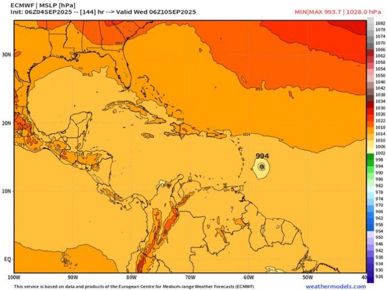
BobHarlem wrote:0z GFS Ensembles are still very different from operational, and so are most of the 0z euro ensembles. Based on this alone the recurve is probably still the most likely. But there needs to be something tangible to track first, either way.

0z GFS Ensembles
https://i.imgur.com/WGXDzMj.png

EPS/Euro Ensembles
https://i.imgur.com/1A7YWFd.png

Google:
https://i.imgur.com/fzPMdtp.png


Agree, this looks like a Bermuda storm but it is so early still.
0 likes   
Emily '87, Felix '95, Gert '99, Fabian '03, Humberto '19, Paulette '20, Teddy '20, Fiona '22, Lee '23, Ernesto '24

jlauderdal
S2K Supporter
S2K Supporter
Posts: 7216
Joined: Wed May 19, 2004 5:46 am
Location: NE Fort Lauderdale
Contact:

Re: Tropical Wave WSW of the Cabo Verde Islands (50/80)

#265 Postby jlauderdal » Thu Sep 04, 2025 7:18 am


Adrian,
We finally received rain on the SE Coast, let's keep the hurricanes away.
J
2 likes   

caneseddy
Category 5
Category 5
Posts: 1182
Joined: Fri Sep 03, 2004 9:31 pm
Location: Plantation, FL

Re: Tropical Wave WSW of the Cabo Verde Islands (50/80)

#266 Postby caneseddy » Thu Sep 04, 2025 7:26 am

6z GFS ends up hitting South Carolina after getting very close to hitting South Florida

Also has another MDR storm right behind it heading to Leewards (bit of course it’s fantasyland)
0 likes   

User avatar
cycloneye
Admin
Admin
Posts: 146491
Age: 69
Joined: Thu Oct 10, 2002 10:54 am
Location: San Juan, Puerto Rico

Re: Tropical Wave WSW of the Cabo Verde Islands (Is Invest 91L)

#267 Postby cycloneye » Thu Sep 04, 2025 8:15 am

3 likes   
Visit the Caribbean-Central America Weather Thread where you can find at first post web cams,radars
and observations from Caribbean basin members Click Here


Return to “Talkin' Tropics”

Who is online

Users browsing this forum: Google [Bot], MarioProtVI, Stratton23 and 111 guests